Lighthouses of Germany: Bremerhaven

The Federal Republic of Germany (Bundesrepublik Deutschland in German) occupies a central location in northern Europe with two coastlines, one facing northwest on the North Sea and the other facing northeast on the Baltic Sea. The country's history is long and complex. The large number of historically independent German regions came together in 1871 to form the German Empire. The Empire became a republic after World War I (1914-18). After World War II (1939-45) Germany was divided into two countries, the German Federal Republic in the west, usually called West Germany, and the Communist-led German Democratic Republic in the east, usually called East Germany. After the Communist government collapsed the Federal Republic reunified the nation in October 1990.

The Federal Republic is a federation of sixteen states (Länder) and the states are divided into districts (Kreise).

The Free Hanseatic City of Bremen (Freie Hansestadt Bremen), one of the 16 states, includes the cities of Bremerhaven and Bremen but not the territory between them; the Cuxhaven District of the state of Niedersachsen (Lower Saxony) surrounds Bremerhaven to the north, east, and south. The state's name refers to the Hanseatic League, which dominated trade in northern Europe from roughly the 13th through the 17th centuries.

This page describes lighthouses of the Bremerhaven area and the Außenweser, the long approach to the Weser through the dangerous shoals of the North Sea. Navigation on the Weser continues upstream from Bremerhaven to Bremen. The Bremen and the Weser page describes the lights of the Weser above Bremerhaven.

Interest in lighthouses is strong in Germany and most of the towers are in good condition. A federal law provides blanket protection to historic lighthouses. There is concern, however, that many of the lights may be deactivated in the coming years as navigators depend less and less on them.

In German, a lighthouse is a Leuchtturm ("light tower"), plural Leuchttürme. The front light of a range is the Unterfeuer and the rear light is the Oberfeuer. There are many modern range lighthouses and most of these towers are crowned by a topmark: a large, distinctive structure that serves to mark the range clearly in the daytime. Some topmarks are conical, others are funnel-shaped, and some consist of one or more gallery-like rings around the tower.

In German Insel is an island, Riff is a reef, Kap is a cape, Bucht is a bay, Fluss is a river, Mündung is a river mouth or estuary, and Hafen is a harbor. The word Straße ("street") is also used for a waterway or strait.

Lighthouses in Germany are operated by the regional harbor authority, called the WSA (Wasserstraßen- und Schiffahrtsamt). This page includes lights maintained by WSA Weser-Jade-Nordsee. The WSA's are linked to and regulated by a federal agency, the Wasserstraßen- und Schifffahrtsverwaltung des Bundes (WSV).

ARLHS numbers are from the ARLHS World List of Lights. DE numbers are the German light list (Leuchtfeuerverzeichnis) numbers as noted on Erich Hartmann's website. Admiralty numbers are from volume B of the Admiralty List of Lights & Fog Signals. U.S. NGA List numbers are from NGA Publication 114.
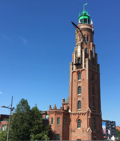

Bremerhaven Oberfeuer, Bremerhaven, June 2022
Instagram photo by ulliusu

General Sources
Online List of Lights - Germany North Sea
Photos by various photographers posted by Alexander Trabas. Many of the photos from this area are by Capt. Peter Mosselberger ("Capt. Peter").
Leuchttürme und Leuchtfeuer an der Nordsee
Photos and information posted by Erich Hartmann, a contributor to the Online List of Lights.
Leuchtturm-Atlas
A large site with excellent photos and information on nearly all German lighthouses, maintained by Frank and Birgit Toussaint.
Leuchttürme.net - Deutschland
Outstanding photos by Malte Werning.
Leuchtturmseiten von Anke und Jens
Photos and and brief accounts in English for many of the lighthouses.
Deutsche Leuchttürme/Feuerschiffe
Photos posted by Klause Huelse.
Lighthouses in Germany
Photos available from Wikimedia.
Deutsche Leuchttürme auf historischen Postkarten
Historic postcard images, also posted by Klaus Huelse.
Feste Schifffahrtszeichen - Leuchttürme
Lighthouse information from WSA Weser-Jade-Nordsee.
Interessengemeinschaft Seezeichen e.V.
Germany's national lighthouse preservation organization.
GPSNavigationCharts
Navigational chart information for Bremerhaven.
Navionics Charts
Navigation chart for Bremerhaven.
Roter Sand Light
Roter Sand Light, Außenweser, September 2010
Wikimedia Creative Commons photo by Kirstin

Hansestadt Bremen: Bremerhaven City Lighthouses

Fischereihafen and Geestemünde (South Bremerhaven) Lighthouses
* Brinkamahof (Weddewarden Unterfeuer, Kleiner Roter Sand) (relocated)
1912. Inactive since 1980. 26 m (85 ft) round cylindrical cast iron tower with lantern and gallery, incorporating keeper's quarters, painted with red and white horizontal bands; lantern dome is black. Florian Pförtsch has a photo, Werning's page has a good photo, Leuchtturm-Atlas also has a good photo, and Google has a satellite view. This lighthouse was originally located near the Imsum container port; on the north side of Bremerhaven; it was deactivated when that port was expanded. In 1980 a large floating crane was used to lift the tower and transport it to the Bootshafen Marina (now called Nordsee-Yachting) on the south side of Bremerhaven, where it has served as a clubhouse and caretaker's residence. Site open, tower closed. Located on the west side of the Wesermarsch harbor, at the south end of the Fischereihafen, on the south side of Bremerhaven. Owner/site manager: Nordsee-Yachting. . ARLHS FED-286.; ex-Admiralty B1234.
* Fischereihafen Oberfeuer (Doppelkorn)
1973. Active; focal plane 45 m (148 ft); white light occulting once every 6 s. 44 m (144 ft) slender round cylindrical tower with a double funnel-shaped topmark. Lighthouse painted with red and white horizontal bands; the topmark is red. Trabas has a good photo by Ulrich Bode, Werning has a photo, H.-D. Bretzke has a 2023 photo, Sven Jachens has a street view, and Google has a satellite view. The light is nicknamed Doppelkorn, "double liqueur-glass." The Fischereihafen range is a upstream (southbound) range for ships passing Bremerhaven and continuing upriver. Located in a parking lot on the Hoebelstraße, in an industrial area on the east side of the Fischereihafen, 1280 m (0.8 mi) southeast of the front light. ARLHS has duplicate listings for these range lights. Site open, tower closed. Operator: WSA Weser-Jade-Nordsee. ARLHS FED-329 (=044); DE 315801; Admiralty B1256.9; NGA 10388.1.
* Geestemünde-Fischereihafen Unterfeuer
1973. Active; focal plane 17 m (56 ft); white light occulting once every 6 s. 11 m (33 ft) slender round cylindrical tower with a funnel-shaped lantern room. This lighthouse serves as the front range tower for both the Geestemünde and Fischereihafen ranges; the lights are displayed through windows in the lantern. Trabas has a closeup photo by Capt. Peter, Werning has a good photo, a 2021 closeup is available, Sven Jachens has a closeup street view, and Google has a satellite view. Located on the dike south of downtown Bremerhaven and near the north end of the Fischereihafen. Site open, tower closed. Operator: WSA Weser-Jade-Nordsee. ARLHS FED-332 (=043); DE 315800 (Fischereihafen) and 316400 (Geestemünde); Admiralty B1257; NGA 10388.
 

Fischereihafen Oberfeuer (Doppelkorn), Bremerhaven
photo copyright Malte Werning; used by permission
 
* Geestemünde Oberfeuer (Doppelschleuse)
1973. Active; focal plane 27 m (89 ft); white light occulting once every 6 s. 25 m (82 ft) slender round cylindrical tower with a large funnel-shaped topmark. Lighthouse painted with red and white horizontal bands; the "funnel" is red. Trabas also has a good photo by Capt. Peter, Werning's page has a photo, Hans-Dieter Bammann has a closeup photo, Sven Jachens has a street view, and Google has a 2023 street view and a satellite view. This is a downstream (northbound) range guiding ships toward the Geestemünde (old harbor). The lighthouse is nicknamed Doppelschleuse ("Double Lock") because it stands between two locks amditting ships to inner harbor basins. Located about 340 m (370 yd) northeast of the front range light on a dike on the north side of the Fischereihafen in Bremerhaven. Site open, tower closed. Operator: WSA Weser-Jade-Nordsee. ARLHS FED-331; DE 315802; Admiralty B1257.1; NGA 10389.1.
* Geeste (Geestemünde) South Mole
1925. Active; focal plane 15 m (49 ft); continuous green light. 14 m (46 ft) square skeletal tower with octagonal lantern and square gallery. Entire lighthouse painted green. Trabas has a good photo by Ulrich Bode, Werning also has a fine photo, Sven Jachens has a street view, and Google has a satellite view. The lower Geeste River is the old harbor of Bremerhaven. Its mouth, the Geestemünde, is also the entrance to the Elbe-Weser Waterway leading to Otterndorf on the lower Elbe. Located at the end of the south mole, which extends only a short distance into the river; accessible by walking the mole. Site open, tower closed. Operator: WSA Weser-Jade-Nordsee. ARLHS FED-047; DE 316030; Admiralty B1275; NGA 10420.
#Geeste (Geestemünde) North Mole (2)
1914 (station established 1857). Removed in 2022; formerly listed with focal plane 15 m (49 ft); continuous red light. 14 m (46 ft) round brick tower with lantern and gallery. Lighthouse unpainted, lantern and gallery painted red. Hannes Grobe's photo is at right, Werning has a good photo, Trabas has an excellent closeup photo by Helmut Seger, Wikimedia has many photos, and Sven Jachens has a 2014 street view from the south mole. In August 2022 the North Mole suddenly began to collapse, causing the lighthouse to lean alarmingly. Cranes removed the lantern for safekeeping and the tower was then demolished along with the mole. The plan is to rebuild the mole and the lighthouse, returning the historic lantern; this work is to be completed in 2026. Meanwhile, in November 2022 a temporary lighthouse, a round steel tower, was installed; it carries a quick-flashing yellow light. Google has a satellite view. To be located at the end of the north mole, which will extend only a short distance into the river. The lighthouse was formerly accessible by walking the mole. Site closed during reconstruction of the mole. Operator: WSA Weser-Jade-Nordsee. ARLHS FED-046; DE 316020; ex-Admiralty B1274; NGA 10416. Temporary light: Admiralty B1274.5.
Geestemünde Nordmole Light
Geestemünde North Mole Light, Bremerhaven, 2008
Wikimedia Creative Commons photo by Hannes Grobe

Downtown Bremerhaven Lighthouses
* Lightship Elbe 3 (Eiderlotsgaliot IV)
1909. Decommissioned 1966. 44 m (144 ft) 3-masted steel lightship. Hull painted red, masts and superstructure white. Built by Eiderwerft AG, Tönning. Leuchturm-Atlas has a good photo, Huelse has a historic photo, and Willy Kaemena has a street view. The ship served as a minesweeper during World War I. From 1927 until World War II, the ship was named Bürgermeister Abendroth II after a Hamburg politician who worked for better conditions for lightship crews. After the war it served the Elbe 3 station off Cuxhaven until 1966. Since 1967 the ship has been moored at Bremerhaven in the collection of the Deutches Schiffahrtsmuseum. The ship has been restored to its original configuration, with three tall masts. The ship was moved to a maintenance yard in May 2023 and Google's current satellite view does not show the ship at its usual mooring. It should return for the 2024 season. Located on the Hans-Scharoun-Platz in downtown Bremerhaven. Site open, ship open daily April through October. Owner/site manager: Deutsches Schiffahrtsmuseum. . ARLHS FED-275.
* Sandstedt Unterfeuer (1) (relocated)
1898. Inactive since 1981. 11 m (34 ft) triangular cast iron skeletal tower with lantern and gallery, painted white; lantern dome is greenish metallic. Werning has a good photo, Wikimedia has Hannes Grobe's closeup, Leuchtturm-Atlas has a photo, Ra Le has a 2017 street view, and Google has a satellite view. The lighthouse was originally located near the village of Sandstedt south of Bremerhaven; after being replaced in 1981 it was relocated in 1983 to the maritime museum. Site open, tower closed. Owner/site manager: Deutsches Schiffahrtsmuseum. ARLHS FED-204.
* Lightship Fehmarnbelt I (lantern)
1905. Inactive since 1968. The lightship was scrapped in 1968 but its lantern is on display outside the maritime museum on the Hans-Scharoun-Platz in downtown Bremerhaven. Lantern painted white. Wikimedia has a closeup by Hannes Grobe, Anke and Jens have a a photo, Willy Kaemena has a street view, and Google has a satellite view. Note: Not to be confused with the intact lightship Fehmarnbelt in Travemünde (see the Flensburg to Lübeck page). Site open. Owner/site manager: Deutsches Schiffahrtsmuseum.
* Bremerhaven Unterfeuer (Zwiebelturm, Minarett)
1893. Active; focal plane 21 m (62 ft); white light, 2 s on, 2 s off, synchronized with the rear light. 26 m (85 ft) tapered-conical round cast iron tower with gallery, crowned by a large ball and a spire. Lighthouse painted with red and white horizontal bands. A photo is at right, Trabas also has a good photo by Ulrich Bode, Werning has a photo, Wikimedia has several photos, Huelse has a historic postcard view, Mat Thias has a street view, and Google has a satellite view. This remarkable Gay Nineties tower has been a Bremerhaven landmark for more than a century. Its nickname Zwiebelturm ("onion tower") refers to its round topmark. The light is part of an upstream (northbound) range, helping ships leaving the Weser negotiate a major turn in the estuary. The lighthouse was relocated by 56 m (184 ft) in 1992 to improve its visibility. In recent years the Bremerhaven zoo has expanded along the waterfront and the lighthouse now stands just outside the zoo grounds. Located on the south side of the entrance to the Neuer Hafen (new harbor) in Bremerhaven. Site open, tower closed. Operator: WSA Weser-Jade-Nordsee. Site manager: Zoo am Meer Bremerhaven. . ARLHS FED-049; DE 316000; Admiralty B1268; NGA 10408.
* Bremerhaven Oberfeuer (Loschenturm)
1855 (Simon Loschen). Active; focal plane 34 m (111 ft); white light, 2 s on, 2 s off, synchronized with the front light. 37 m (121 ft) square brick New Gothic tower with octagonal lantern. Tower is unpainted brick, lantern painted green. On the side of the tower is a large iron bracket structure formerly used to display storm signals. A 2022 photo appears at the top of the page, Werning has a nice photo, Trabas also has a good photo by Ulrich Bode, Wikimedia has many photos, Huelse has a historic postcard view, Peter Skrodolies has a street view, and Google has a satellite view. This elegant lighthouse, designed by the Bremen architect Simon Loschen, could not be more different from the front range tower. The oldest operating lighthouse of Germany's North Sea mainland, it narrowly escaped destruction during World War II. It is called the Loschenturm (Loschen's tower") to honor its architect. Located about 200 m (220 yd) north of the front light, near a former lock that provided entry to the Neuer Haven (originally the light keepers also operated the lock). Site open, tower closed. Operator: WSA Weser-Jade-Nordsee. . ARLHS FED-050; DE 316001; Admiralty B1268.1; NGA 10412.

Zwiebelturm, Bremerhaven, February 2019
Instagram photo by viaggiodichiara
* Kaiserschleuse (Kaiserhafen East Mole, Klingelturm, Pingelturm)
1900. Inactive since 2011. 15 m (49 ft) tapered round brick tower with lantern and gallery, the lantern crowned with a spike like that of an Imperial Army helmet. Lighthouse unpainted red brick with white false window casings; lantern is green. The original fog bell is mounted on the side of the tower. A photo is at right, Peter Lindenau has a 2021 photo, Werning has a good photo, Larry Myhre has a photo, Wikimedia has several good photos, a 2022 photo is available, Huelse has a historic postcard view, Peter Skrodolies has a closeup street view, and Google has a satellite view. The elegant turn-of-the-century architecture of this lighthouse makes it a unique historic treasure. The light guided ships into the Kaiserhafen, a protected harbor in downtown Bremerhaven entered through a lock, the Kaiserschleuse. The familiar sound of the fog bell gave the lighthouse the local nicknames of Klingelturm or Pingelturm. Located on the east side of the harbor entrance, on the north side of downtown Bremerhaven. Site open, tower closed. Owner: WSA Weser-Jade-Nordsee. . ARLHS FED-338; ex-Admiralty B1264.
* [Kaiserscheuse Ost]
2011. Active; focal plane 16 m (52 ft); continuous green light. 11 m (36 ft) skeletal mast painted green. Fog horn (11 s blast every 60 s). Trabas has Capt. Peter's photo and Google has a satellite view. Located at the end of a breakwater about 80 m (270 ft) south of the Pingelturm. Accessible by walking the pier. Site open, tower closed. Operator: WSA Weser-Jade-Nordsee. DE 315880; Admiralty B1264.5; NGA 10404.
[Kaiserscheuse West]
2011. Active; focal plane 15 m (49 ft); continuous red light. 11 m (36 ft) skeletal mast painted red. Fog horn (11 s blast every 60 s). Trabas has Capt. Peter's photo and Google has a satellite view. Located on the west side of the entrance to the Kaiserscheuse locks leading an inner harbor basin. Site and tower closed but there's a good view from the Pingelturm. Operator: WSA Weser-Jade-Nordsee. DE 315870; Admiralty B1262; NGA 10400.

Der Pingelturm, Bremerhaven, July 2011
Wikimedia Creative Commons photo by Neuwieser
* Großer Vogelsand (upper section relocated to Bremerhaven)
1975 (relocated to Bremerhaven in 2010). Approx. 15 m (49 ft) 16-sided steel tower topped by a helipad. Building painted red with a white horizontal band. This structure is the top of the former Großer Vogelsand lighthouse, which stood in the North Sea off the entrance to the Elbe (see the Cuxhaven and Stade page). The top of the lighthouse was removed in December 2008 and brought to Bremerhaven to be scrapped. Instead, the huge unit was moved in June 2010 to the Havenhostel Nordwest, where it was renovated as part of the hostel. Wikimedia has a photo of the move. Florian Pförtsch has a closeup photo, another photo and a drone view are available, and Google has a street view and a satellite view. Located on the Bürgermeister-Smidt-Straße at the Rickmersstraße on the north side of downtown Bremerhaven. Site presumably open, tower status unknown. Owner/site manager: Havenhostel Nordwest. ex-Admiralty B1340.

Imsum (North Bremerhaven) Lighthouses
#Imsum
1952. Inactive since 1998 and removed in 2006. 21 m (62 ft) slender round cylindrical tower with lantern, watch room, and gallery. Lighthouse painted red with two narrow white bands around the watch room; lantern roof was green. According to Werning the lantern was from an earlier, unidentified lighthouse. Werning has a fine photo, and the Anke/Jens site also has a good closeup photo. The lighthouse was removed to make way for expansion of the Imsum containership terminal. The lighthouse was stored for a time at the Deutsches Schiffahrtsmuseum but Werning reports it was scrapped in 2016. Formerly located just offshore a short distance southeast of the Imsum Oberfeuer. Site appears to be open, tower closed. ARLHS FED-119; ex-Admiralty B1238.
* Imsum Oberfeuer (1)
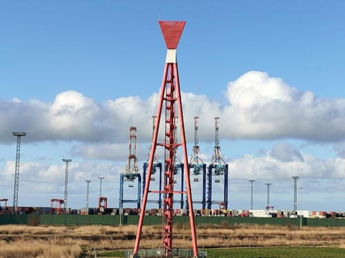
1959. Inactive since 2007. 43 m (141 ft) steel tripod tower with a central spiral stairway, topped by a triangular funnel-shaped topmark. Lighthouse painted red. A 2023 photo is at right, Jakub Sobczyński has a 2021 photo, Werning has a good photo, Peter Lindenau has a distant street view, and Google has a fine satellite view. This is the only Außenweser light station built on land. Located just north of the Imsum container ship terminal on the west bank of the Weser at Weddewarden north of Bremerhaven. Site appears to be open, tower closed. Owner: WSA Weser-Jade-Nordsee. ARLHS FED-336.
* Imsum Oberfeuer (2)
2009 (station establishment date unknown). Active; focal plane 39 m (128 ft); white light occulting once every 6 s, synchronized with the front light. 43 m (141 ft) round cylindrical tower with gallery, painted red with a white horizontal band. Lighthouse painted red with a single white horizontal band. Trabas has a closeup photo by Capt. Peter, Kevin Bremer has a very distant street view, and Google has a satellite view. Located on the dike north of the Imsum container ship terminal. Site appears to be open, tower closed. Operator: WSA Weser-Jade-Nordsee. DE 315541; Admiralty B1230.1; NGA 10382.
Imsum Unterfeuer (2)
2009 (station establishment date unknown). Active; focal plane 21 m (69 ft); white light occulting once every 6 s, synchronized with the rear light. 21 m (69 ft) round cylindrical tower with gallery, painted red with a white horizontal band. The tower also carries a slatted triangular daymark, painted red. Trabas has a good photo by Capt. Peter, Florian Pförtsch has a view from shore (the Hofe range lights are also seen in the distance), Sven Jachens has a very distant drone view, and Google has a satellite view. Located in the water 900 m (0.56 mi) west northwest of the rear light. Accessible only by boat. Site open, tower closed. Operator: WSA Weser-Jade-Nordsee. ARLHS FED-337; DE 315540; Admiralty B1230; NGA 10381.

Original Imsum Oberfeuer, Weddewarden, February 2023
Google Maps photo by Georg

Niedersachsen: Wurster Nordseeküste Lighthouses

On 1 January 2015 the seacoast communities of Lower Saxony between Bremerhaven and Cuxhaven were combined to form the municipality of Wurster Nordseeküste.

Wremen Lighthouses
Hofe Unterfeuer
1974. Active; focal plane 15 m (49 ft); white light occulting once every 6 s, synchronized with the rear light. 22 m (72 ft) slender round cylindrical tower with a distinctive clamshell-like topmark. Lighthouse painted with red and white horizontal bands. Werning has a good photo, Trabas has a closeup photo by Capt. Peter, a 2020 photo is available, and Google has a satellite view. This is an outbound range, guiding ships leaving the Weser. Located about 2.5 km (1.5 mi) west of the coast southwest of Wremen. Accessible only by boat. Site open, tower closed. Operator: WSA Weser-Jade-Nordsee. ARLHS FED-297; DE 315620; Admiralty B1240; NGA 10376.
Hofe Oberfeuer
1974. Active; focal plane 35 m (115 ft); white light occulting once every 6 s, synchronized with the front light. 43 m (141 ft) slender round cylindrical tower with a distinctive clamshell-like topmark. Lighthouse painted with red and white horizontal bands. Werning has a good photo, Trabas has a closeup photo by Capt. Peter, a 2020 photo is available, and Google has a satellite view. Located 1300 m (0.8 mi) north northwest of the front light. Accessible only by boat. Site open, tower closed. Operator: WSA Weser-Jade-Nordsee. ARLHS FED-298; DE 315621; Admiralty B1240.1; NGA 10380.
** Wremen (Kleine-Preuße, Wremertief) (replica)
2005 replica of 1906 lighthouse. Inactive (a decorative continuous white light is displayed toward the land). Approx. 12 m (39 ft) round cylindrical tower with lantern and gallery, painted with black and white horizontal bands. Hartmann has a page for the lighthouse, Gabriele Heß has a 2020 photo, Martina aus Beers has a good 2008 photo, Huelse has a historic postcard view of the original lighthouse, and Google has a street view and a satellite view. The original lighthouse was demolished in 1930. The prefabricated replica was erected in a single day in April 2005. Located on the north side of the harbor entrance in Wremen, a town between Dorum and Bremerhaven, now part of the municipality of Wurster Nordseeküste. Site open, tower open for climbing but no schedule is available. Owner/site manager: Wurster Nordseeküste. .

Dorum Lighthouse
** Obereversand (Eversand Oberfeuer) (relocated to Dorum)
1887. Reactivated (inactive 1923-2004; now privately maintained); focal plane 29 m (95 ft); continuous white light. 34 m (112 ft) square cast iron tower with lantern and gallery, incorporating 3-story keeper's quarters, mounted on a square skeletal foundation. Lighthouse painted dark brown. Gerd Grabo's photo is at right, Hartmann has a page for the lighthouse, Werning has a page for the lighthouse with a good photo, Trabas has Capt. Peter's photo, Sonja Singh has a 2021 photo, Olaf Strunck has another photo, Karsten Planz has a street view, and Google has a satellite view. By the 1990s the foundation of this Außenweser lighthouse was undermined and the tower was in danger of collapse. In 1999 a preservation society was formed to work with the national park service for relocation and restoration of the lighthouse. In early 2003 the lighthouse was ingeniously lifted off its foundations and barged to the harbor of Dorum, where it was installed on a new foundation just offshore and fully restored. Leuchturm-Atlas has a portfolio of photos of the relocation. A pier and and external stairway provides access to the gallery and lantern room. The light was relit in a ceremony on 14 August 2004. The skeletal section was restored in 2019. Located on the waterfront at Dorum. Site open, tower open on weekends (inquire locally for the schedule of tours). Owner: Nationalpark Niedersächsisches Wattenmeer. Site manager: Förderverein Leuchtturmdenkmal Obereversand e.V. . ARLHS FED-084; DE 315450; Admiralty B1309.

Obereversand Light, Dorum, September 2019
Google Maps photo by Gerd Grabo

Außenweser Offshore Lighthouses

This remarkable collection of offshore lighthouses guides ships through extensive shoals at the entrance to the Weser estuary and the port of Bremerhaven. The area is called the Außenweser, the "Outer Weser."

Solthörn Unterfeuer
1981. Active; focal plane 15 m (49 ft); white light 2 s on, 2 s off, synchronized with the rear light. 20 m (65 ft) slender round cylindrical tower with an octagonal 2-ringed topmark. Lighthouse painted red with two horizontal white bands. Trabas has Helmut Seger's closeup photo, Werning has a good photo, and Google has a satellite view. Like the Hofe Range, this is an outbound range, guiding ships leaving the Weser. Located about 4 km (2.5 mi) west of the coast northwest of Wremer. Accessible only by boat. Site open, tower closed. Operator: WSA Weser-Jade-Nordsee. ARLHS FED-341; DE 315600; Admiralty B1239; NGA 10368.
Solthörn Oberfeuer
1981. Active; focal plane 31 m (102 ft); white light 2 s on, 2 s off, synchronized with the front light. 33 m (108 ft) slender round cylindrical tower with an octagonal 2-ringed topmark. Lighthouse painted red with two horizontal white bands. Trabas has Helmut Seger's closeup photo, Werning has a good photo, and Google has a satellite view. Located 700 m (0.44 mi) north northwest of the front light. Accessible only by boat. Site open, tower closed. Operator: WSA Weser-Jade-Nordsee. ARLHS FED-340; DE 315601; Admiralty B1239.1; NGA 10372.
Wremer Loch Oberfeuer
1967. Active; focal plane 31 m (102 ft); white light 3 s on, 3 s off, synchronized with the rear light. 34 m (112 ft) slender round cylindrical tower with lantern and a small octagonal gallery. Lighthouse painted black with two white bands; lantern painted green. Trabas has Capt. Peter's closeup photo, Werning also has a photo, and Google has a satellite view. This is an inbound range guiding arriving vessels. Located 1060 m (0.7 mi) northwest of the front light. Accessible only by boat. Site open, tower closed. Operator: WSA Weser-Jade-Nordsee. ARLHS FED-343; DE 315481; Admiralty B1224.1; NGA 10364.
Wremer Loch Unterfeuer
1967. Active; focal plane 15 m (49 ft); white light 3 s on, 3 s off, synchronized with the rear light. 18 m (59 ft) slender round cylindrical tower with lantern and a small octagonal gallery. Lighthouse painted black with one white band; lantern painted green. Trabas has Capt. Peter's closeup photo, Werning's photo is at right, and Google has a satellite view. Located about 3 km (2 mi) southeast of Langlütjen Range Front. Accessible only by boat. Site open, tower closed. Operator: WSA Weser-Jade-Nordsee. ARLHS FED-342; DE 315480; Admiralty B1224; NGA 10360.
Wremer Loch Unterfeuer
photo copyright Malte Werning; used by permission
Langlütjen Unterfeuer
1970. Active; focal plane 15 m (49 ft); white light occulting once every 6 s, synchronized with the rear light. 19 m (62 ft) slender round cylindrical tower with a large octagonal gallery. Lighthouse painted black with two white bands around the gallery. Werning has a good photo, Trabas has Capt. Peter's closeup photo, Andreas Köhler has a photo, and Google has a satellite view. This is an outbound range, guiding ships leaving the Weser. Located about 5 km (3 mi) southeast of Langlütjennordsteert. Accessible only by boat. Site open, tower closed. Operator: WSA Weser-Jade-Nordsee. ARLHS FED-302; DE 315500; Admiralty B1228; NGA 10352.
Langlütjen Oberfeuer
1970. Active; focal plane 31 m (102 ft); white light occulting once every 6 s, synchronized with the front light. 34 m (112 ft) slender round cylindrical tower with a small octagonal gallery. Lighthouse painted black, gallery white. Trabas has Capt. Peter's closeup photo, Werning also has a good photo, and Google has a satellite view. Located 930 m (0.6 mi) northwest of the front light. Accessible only by boat. Site open, tower closed. Operator: WSA Weser-Jade-Nordsee. ARLHS FED-303; DE 315501; Admiralty B1228.1; NGA 10356.
Langlütjennordsteert
1930. Inactive since 2001 although still listed by NGA as a tidal guage; maintained as a daybeacon. 16 m (52 ft) structure: lantern, gallery, and watch room on tripod pilings. Lantern, including roof, painted yellow; tripod legs painted black. Werning also has a good photo and Google has a satellite view. Sibling of Robbennordsteert. The lighthouse remains in service as a daybeacon. Located about 2 km (1.2 mi) east of the Robbenplate Oberfeuer. Accessible only by boat. Site open, tower closed. Operator: WSA Weser-Jade-Nordsee. ARLHS FED-304; ex-Admiralty B1226; NGA 10350.
Robbenplate Oberfeuer
1925. Active; focal plane 37 m (121 ft); white light, 4.5 s on, 1.5 s off, synchronized with the front light. 39 m (127 ft) square aluminum-clad brick tower incorporating keeper's quarters, with lantern and four galleries. Lighthouse painted red with white trim. The lantern (1906) was transferred from the Meyers Legde Neu Light. Werning's photo is at right, Hartmann has a page for the lighthouse, Uwe Milte has a closeup, Wikimedia has a 2011 photo, Trabas has a good photo by Helmut Seger, and Google has a satellite view. The lantern room was transferred from the original Meyers Legde lighthouse (see below), but the active light is now shown from the mast atop the tower (added in 1988). Located about 3.5 km (2 mi) southeast of the Robbennordsteert Light, at the west end of the Robbenplate shoal. Accessible only by boat. Site open, tower closed. Operator: WSA Weser-Jade-Nordsee. ARLHS FED-198; DE 315351; Admiralty B1214.1; NGA 10344.
Robbenplate Unterfeuer
1925. Active; focal plane 16 m (52 ft); white light, 4.5 s on, 1.5 s off, synchronized with the rear light. !6 m (52 ft) round post atop robust tripod piles. Trabas has a good photo by Helmut Seger, Werning's page has a photo, and Google has a satellite view. Located about 1 km (0.6 mi) northwest of the rear light. Accessible only by boat. Site open, tower closed. Operator: WSA Weser-Jade-Nordsee. ARLHS FED-361; DE 315350; Admiralty B1214; NGA 10340.
Robbennordsteert
Date unknown. Active; focal plane 11 m (36 ft); continuous white or red light, depending on direction. 16 m (52 ft) structure: lantern, gallery, and watch room on tripod pilings. Lantern painted red; lantern roof and tripod legs painted black. Werning has a fine photo, Trabas has Capt. Peter's closeup photo, and Google has a satellite view. Located about 2 km (1.25 mi) southeast of Dwarsgat Range Rear Light. Accessible only by boat. Site open, tower closed. Operator: WSA Weser-Jade-Nordsee. ARLHS FED-199; DE 315400; Admiralty B1210; NGA 10336.
Robbenplate Oberfeuer
photo copyright Malte Werning; used by permission
Meyers Legde Neu
1906. Inactive since 1923. 24 m (79 ft) round cylindrical cast iron tower; the lantern was removed and transferred to the Robbenplate Oberfeuer (see above). The tower is the background of Capt. Peter's photo of the Robbennordsteert Light and Google has a satellite view. Note that Google Maps has incorrect labels on the two Meyers Legde lighthouses. Located about 750 m (1/2 mi) south of the older lighthouse. Accessible only by boat. Site open, tower closed. Site manager:Nationalpark Niedersächsisches Wattenmeer. ARLHS FED-156.
Meyers Legde Alt
1887. Inactive since 1945. 26 m (85 ft) square cast iron tower incorporating 3-story keeper's quarters, mounted on a square skeletal foundation. Lantern removed. Google has a satellite view. Like the Eversand Range Lights, the Meyers Legde lighthouses guided ships on a secondary entrance to the Weser from the north. Also like the Eversand Unterfeuer (next entry), the interior of the lighthouse was gutted by fire at some time after deactivation. In 1986 ledges were added to the tower as nesting sites for cormorants, and this lighthouse is also now white with bird droppings. Located about 3 km (2 mi) east of Eversand Range Front Light. Accessible only by boat. Site open, tower closed. Site manager:Nationalpark Niedersächsisches Wattenmeer. ARLHS FED-339.
Eversand Unterfeuer
1887. Inactive since 1923. 21 m (69 ft) square cast iron tower incorporating 3-story keeper's quarters, mounted on a square skeletal foundation. Mindy Simmons has a 2023 closeup and the photo at right and Google has a satellite view. The range guided ships on a secondary entrance to the Weser from the north. The interior of the lighthouse was gutted by fire at some time after deactivation. In 1982 ledges were added to the tower as nesting sites for cormorants. This succeeded, if anything, only too well; the lighthouse, originally painted black, is now white with bird droppings. The rear range light was successfully relocated to Dorum-Neufeld in 2003 (see above). Located about 2 km (1.2 mi) east of the Dwarsgat Unterfeuer Light. Accessible only by boat. Site open, tower closed. Site manager: NNationalpark Niedersächsisches Wattenmeer. ARLHS FED-083.

Eversand Unterfeuer, Außenweser, June 2023
Google Maps photo by Mindy Simmons
Dwarsgat Oberfeuer
1976. Active; focal plane 35 m (115 ft); white light, 3 s on, 3 s off, synchronized with the front range. 36 m (118 ft) slender round cylindrical tower with a drum-shaped lantern and topmark and a gallery low on the tower. Lighthouse painted red with two white horizontal bands. Trabas has Helmut Seger's closeup photo, Werning also has a good photo, and Google has a satellite view. This is an inbound range. Located about 4 km (2.5 mi) east northeast of the Hohe Weg Light, marking the main channel into the Weser and Bremerhaven. Accessible only by boat. Site open, tower closed. Operator: WSA Weser-Jade-Nordsee. ARLHS FED-292; DE 315441; Admiralty B1225.1; NGA 10332.
Dwarsgat Unterfeuer
1976. Active; focal plane 16 m (52 ft); white light, 3 s on, 3 s off, synchronized with the rear range. 19 m (62 ft) round cylindrical tower with a drum-shaped lantern and topmark, painted red with one white horizontal band. Werning has a good photo, Trabas has Capt. Peter's closeup photo, and Google has a satellite view. Located about 4 km (2.5 mi) east northeast of the Hohe Weg Light, marking the main channel into the Weser and Bremerhaven. Accessible only by boat. Site open, tower closed. Operator: WSA Weser-Jade-Nordsee. ARLHS FED-291; DE 315440; Admiralty B1225; NGA 10328.
Hohe Weg
1856 (Johann J. van Ronzelen). Active; focal plane 29 m (95 ft); continuous light, white, red, or green depending on direction. 36 m (118 ft) octagonal aluminum-clad brick tower with lantern and double gallery. Keeper's quarters incorporated in the tower. Lighthouse painted red with white trim; lantern painted green. The original 2nd order Sautter, Lemonier & Cie. Fresnel lens is on display at the Deutsches Schiffahrtsmuseum in Bremerhaven. A photo is at right, Trabas has an excellent photo by Capt. Peter, German Wikipedia has an article with several photos, Hartmann has a page for the lighthouse, Werning has a photo, Dirk Michel has a photo, and Google has a satellite view. This historic lighthouse guides ships around a dangerous shallow area called the Hohe Weg (high way) off the entrance to the Weser. The modern lantern and radar antenna were installed in 1962; Huelse has a historic postcard view showing the tower in its original appearance. Located off the south side of the Außenweser channel about 25 km (15 mi) northwest of Bremerhaven. Accessible only by boat. Site open, tower closed. Operator: WSA Weser-Jade-Nordsee. ARLHS FED-108; DE 315300; Admiralty B1198; NGA 10324.
Tegeler Plate
1965. Active; focal plane 21 m (68 ft); white, red, or green light depending on direction, occulting three times every 12 s. 24 m (79 ft) round cylindrical steel tower with lantern and gallery atop an octagonal equipment room. Lighthouse painted red, lantern white. Hartmann has a page for the lighthouse, Werning also has a page for the lighthouse, Trabas has Capt. Peter's closeup photo, and Google has a satellite view. This lighthouse replaced the Bremen lightship station. Located in a shoal area north of the Außenweser channel about 15 km (9 mi) southeast of Alte Weser. Accessible only by boat. Site open, tower closed. Operator: WSA Weser-Jade-Nordsee. ARLHS FED-020; DE 315200; Admiralty B1196; NGA 10320.
Hohe Weg Light
Hohe Weg Light, Außenweser, September 2011
Wikimedia Creative Commons photo by Kirstin
Alte Weser
1964 (Andreas Carstens). Active; focal plane 33 m (108 ft); continuous light, white, red, or green depending on direction; there are 12 sectors in all. 38 m (125 ft) round inverted-conical concrete and steel tower with lantern and gallery and a 2-story overhanging observation and control center about 2/3 of the way up the tower. Lighthouse painted red with two white horizontal bands; lantern painted green. Fog horn (Morse code "AL," short-long-short-long-short-short, every 60 s). Jens Mehlinger's 2023 photo is at right, Werning has a good photo, Trabas has a good photo by Capt. Peter, Hartmann has a page for the lighthouse, and German Wikipedia has an article with photos, but the lighthouse is not shown in Google's satellite view. Three years' work was needed to build this striking modern lighthouse. "Alte Weser" (Old Weser) is the name of the original approach to the Weser; it has been replaced for the most part by the Neue Weser (New Weser) channel to the south. Located about 3 km (2 mi) northeast of Roter Sand. Accessible only by boat. Site open, tower closed. Operator: WSA Weser-Jade-Nordsee. ARLHS FED-001; DE 315000; Admiralty B1188; NGA 10308.
Roter Sand
1885. Inactive since 1986. 28 m (92 ft) round cast iron, brick lined tower with primary and secondary lanterns and a triangular gallery, built on a steel caisson. Keeper's quarters incorporated in the tower. Lighthouse painted with red and white horizontal bands; the base of the tower and roofs of the lanterns are black. A photo is near the top of this page, Werning has a page with a great photo, Hartmann also has a page for the lighthouse, Wikimedia has an excellent photo by Markus Jastroch, Tim Boettger also has a good photo, and Huelse has a historic postcard view but the lighthouse is not shown in Google's satellite view. The former fog bell of the lighthouse is on display at the Deutsches Schiffahrtsmuseum in Bremerhaven. This is one of the world's great waveswept lighthouses. Construction of the tower posed enormous difficulties; the first attempt failed when a storm overturned the incomplete caisson on 13 October 1881. The light was downgraded in 1964 when Alte Weser took over its function as the landfall light for Bremerhaven. When the light was deactivated in 1986 there was immediate concern that the lighthouse would be lost. However, WSA Bremerhaven restored and strengthened the foundation of the tower in 1987, and in that same year a foundation was established to raise funds for preservation and restoration. Since 1999 the tower has been open for day tours and overnight stays. Located in the North Sea off the entrance to the Weser, about 10 km (6 mi) northeast of the island of Wangerooge. Accessible only by boat. Site open, tower open to tours. Owner: Nationalpark Niedersächsisches Wattenmeer. Site manager: Förderverein Leuchtturm Roter Sand . ARLHS FED-019.

Alte Weser Light, Außenweser, June 2023
Google Maps photo by Jens Mehlinger

Information available on lost lighthouses:

Notable faux lighthouses:

Adjoining pages: North: Cuxhaven and Stade | South: Bremen and the Weser | West: Borkum to Wilhelmshaven

Return to the Lighthouse Directory index | Ratings key

Posted February 26, 2005. Checked and revised January 7, 2024. Lighthouses: 38; lightships: 2. Site copyright 2024 Russ Rowlett and the University of North Carolina at Chapel Hill.