Lighthouses of Germany: Bremen and the Weser

The Federal Republic of Germany (Bundesrepublik Deutschland in German) occupies a central location in northern Europe with two coastlines, one facing northwest on the North Sea and the other facing northeast on the Baltic Sea. The country's history is long and complex. The large number of historically independent German regions came together in 1871 to form the German Empire. The Empire became a republic after World War I (1914-18). After World War II (1939-45) Germany was divided into two countries, the German Federal Republic in the west, usually called West Germany, and the Communist-led German Democratic Republic in the east, usually called East Germany. After the Communist government collapsed the Federal Republic reunified the nation in October 1990.

The Federal Republic is a federation of sixteen states (Länder) and the states are divided into districts (Kreise).

Bremen, on the estuary of the Weser River, is one of Germany's historic North Sea ports. Bremen was one of the members of the Hanseatic League, which dominated trade in northern Europe from roughly the 13th through the 17th centuries. Today the Free Hanseatic City of Bremen (Freie Hansestadt Bremen), one of the states of the Federal Republic, includes the two cities of Bremen and Bremerhaven but not the territory between them: that area is part of the state of Lower Saxony (Niedersachsen).

This page describes lighthouses of Bremen and the Weser estuary between Bremen and the deeper water port of Bremerhaven. Lights of Bremerhaven and the Außenweser (the approach to the Weser) are on a separate page. Of the active lighthouses listed on this page only the Mäuseturm (seen at right), the Gitterbake light, and the two Seehausen mole lights are in city of Bremen; all the rest are in the Wesermarsch or Osterholz districts of Lower Saxony.

Interest in lighthouses is strong in Germany and most of the towers are in good condition. A federal law provides blanket protection to historic lighthouses. There is concern, however, that many of the lights may be deactivated in the coming years as navigators depend less and less on them.

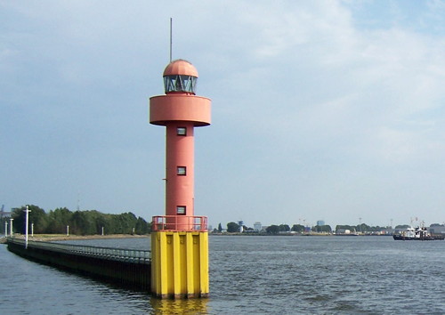
In German a lighthouse is a Leuchtturm ("light tower"), plural Leuchttürme. The front light of a range is the Unterfeuer and the rear light is the Oberfeuer. There are many modern range lighthouses and most of these towers are crowned by a topmark: a large, distinctive structure that serves to mark the range clearly in the daytime. Some topmarks are conical, others are funnel-shaped, and some consist of one or more gallery-like rings around the tower. The Nordenham Unterfeuer, shown at right, is a good example.

In German Insel is an island, Riff is a reef, Kap is a cape, Bucht is a bay, Fluss is a river, Mündung is a river mouth or estuary, and Hafen is a harbor. The word Straße ("street") is also used for a waterway or strait.

Lighthouses in Germany are operated by the regional harbor authority, called the WSA (Wasserstraßen- und Schiffahrtsamt). The lights on this page are maintained by WSA Weser-Jade-Nordsee. The WSA's are linked to and regulated by a federal agency, the Wasserstraßen- und Schifffahrtsverwaltung des Bundes (WSV).

ARLHS numbers are from the ARLHS World List of Lights. DE numbers are the German light list (Leuchtfeuerverzeichnis) numbers as noted on Erich Hartmann's website. Admiralty numbers are from volume B of the Admiralty List of Lights & Fog Signals.

General Sources
Online List of Lights - Germany North Sea
Photos by various photographers posted by Alexander Trabas. Many of the photos from this area are by Capt. Peter Mosselberger ("Capt. Peter").
Leuchttürme und Leuchtfeuer an der Nordsee
Photos and information posted by Erich Hartmann, a contributor to the Online List of Lights.
Leuchtturm-Atlas
A large site with excellent photos and information on nearly all German lighthouses, maintained by Frank and Birgit Toussaint.
Leuchttürme.net - Deutschland
Outstanding photos by Malte Werning.
Leuchtturmseiten von Anke und Jens
Good photos and and brief accounts for many of the lighthouses, in English.
Deutsche Leuchttürme/Feuerschiffe
Photos posted by Klause Huelse.
Deutsche Leuchttürme auf historischen Postkarten
Historic postcard images, also posted by Klaus Huelse.
Leuchttürme und Seezeichen
Photos on Flickr.com by Udo Borchers.
Lighthouses in Germany
Photos by various photographers available from Wikimedia.
Feste Schifffahrtszeichen - Leuchttürme
Lighthouse information from WSA Weser-Jade-Nordsee.
Interessengemeinschaft Seezeichen e.V.
Germany's national lighthouse preservation organization.
GPSNavigationCharts
Navigation chart information for the Weser.
Navionics Charts
Navigation chart information for the Weser.


Der Mäuseturm, Bremen, August 2014
Wikimedia Creative Commons photo by Oberlausitzerin64


Nordenham Unterfeuer, Großensiel
photo copyright Capt. Peter Mosselberger; used by permission

Eastern Wesermarsch District (Weser West Bank) Lighthouses

Nordenham Area Lighthouses
Nordenham is a town on the west bank of the Weser and on the east side of the Butjadingen peninsula, a short distance upstream from Bremerhaven. The peninsula separates the Jade Bight from the Weser estuary. For Butjadingen lighthouses of the Jade, see the Borkum to Wilhelmshaven page.

*
Reitsand Unterfeuer
1981. Active; focal plane 18 m (59 ft); white light occulting once every 6 s. Approx. 14 m (45 ft) slender round cylindrical tower with a large single-ring topmark, painted with red and white horizontal bands. Trabas has a good photo by Capt. Peter, Sascha Meyer has a 2020 photo, and Google has a satellite view. This is an upstream (southbound) range guiding ships from Bremerhaven southwestward toward Nordenham. Located onshore on the west side of the Weser between Blexen and Nordenham. Site open, tower closed. Operator: WSA Weser-Jade-Nordsee. ARLHS FED-196; DE 316440; Admiralty B1279.9.
Reitsand-Flagbalgersiel Oberfeuer
1981. Active; focal plane 36 m (118 ft); white light occulting once every 6 s. Approx. 23 m (75 ft) slender round cylindrical tower with a double-ring topmark, painted with red and white horizontal bands. Werning has a good photo, Trabas also has a good closeup photo by Capt. Peter, Sascha Meyer has a photo, and Google has a street view and a satellite view. This tower is the rear light for both the upstream Reitsand and downstream Flagbalgerseil ranges. Located about 480 m (0.3 mi) southwest of the Reitsand Unterfeuer and 580 m (0.35 mi) north of the Flagbalgerseil Unterfeuer. Site and tower closed. Operator: WSA Weser-Jade-Nordsee. ARLHS FED-197; DE 316461; Admiralty B1280.
Flagbalgersiel Unterfeuer
1981. Active; focal plane 18 m (59 ft); white light occulting once every 6 s. Approx. 16 m (52 ft) slender round cylindrical tower with a large single-ring topmark, painted with red and white horizontal bands. Sascha Meyer's 2020 photo is at right, Trabas has a good closeup photo by Ingo Becker, and Google has a satellite view. This is the front light of a downstream (northbound) range. Located behind a dike and adjacent to an industrial property on the west bank of the river somewhere to the north of Nordenham. Site and tower closed. Operator: WSA Weser-Jade-Nordsee. ARLHS FED-330; DE 316460; Admiralty B1280.1.
* Einswarden Oberfeuer (lantern)
1896. Inactive since 1978. Lantern with gallery, painted white with a green dome. This is the lantern and Fresnel lens of the original Einswarden Oberfeuer lighthouse, now displayed in front of the town museum in Nordenham. Werning has a page with a good photo and Google has a street view and a satellite view. The original lighthouse was of the same design as the surviving Großensiel Unterfeuer, which served originally as the Einswarden Unterfeuer (see below). Located at 18 Hansingstraße, Nordenham. Site open; visitors can climb several steps to the gallery of the lantern. Owner/site manager: Museum Nordenham.
* Nordenham Oberfeuer
1980. Active; focal plane 41 m (135 ft); white light occulting once every 4 s. 39 m (128 ft) slender round cylindrical tower with a large funnel-shaped 3-ring topmark, painted with red and white horizontal bands. Lighthouse painted with red and white horizontal bands. Trabas has a good closeup photo by Capt. Peter, Werning has a good photo, Frank Czerwinski has a 2021 photo, Kersten Bokemüller has a 2023 photo, Borchers has a 2008 closeup, and Google has a satellite view. This is the rear light of a downstream (northbound) range. Located on the west bank of the river close to the railway station in Nordenham. Site open, tower closed. Operator: WSA Weser-Jade-Nordsee. ARLHS FED-170; DE 316741; Admiralty B1286.1.

Flagbalgersiel Unterfeuer, Nordenham, May 2020
Google Maps photo by Sascha Meyer
* Großensiel Unterfeuer
1898 (relocated 1914). Active; focal plane 16 m (52 ft); white light occulting once every 4 s. 17 m (56 ft) triangular skeletal tower with lantern, enclosed watch room, gallery, and partially enclosed central stairway. Lighthouse painted white; the lantern dome is greenish metallic. Werning's photo is at right, Trabas has an excellent closeup photo by Capt. Peter, Detlef Glückselig has a 2021 photo, and Google has a satellite view and a street view across the river. This is an upstream (southbound) range. The lighthouse is one of a series of lighthouses of this design installed in or around 1898. It served originally as the front light for the Einswarden range, near Nordenham. It was relocated in 1914. Located on the west bank of the river about 2 km (1.2 mi) south of Nordenham. Site open, tower closed. Operator: WSA Weser-Jade-Nordsee. ARLHS FED-333; DE 316500; Admiralty B1284.
* Großensiel Oberfeuer (2)
1962 (station established 1914). Active; focal plane 25 m (82 ft); white light occulting once every 4 s. 23 m (75 ft) square steel skeletal tower with gallery, painted black. Werning also has a good photo, Trabas has Capt. Peter's photo, Peter Michel has a 2020 photo, and Google has a street view and a satellite view. Located just off the Treuenfelder Weg 427 m (1400 ft) south of the front light. Site open, tower closed. Operator: WSA Weser-Jade-Nordsee. ARLHS FED-296; DE 316501; Admiralty B1284.1.
Nordenham Unterfeuer
1980. Active; focal plane 13 m (43 ft); white light occulting once every 4 s. 17 m (56 ft) slender round cylindrical tower with a large conical 2-ring topmark, painted red with one white horizontal band. Trabas has a photo by Capt. Peter (also seen at the top of this page), Sascha Meyer has a photo, Matthias Blum has a distant street view, and Google has a satellite view. Located in the water on the west side of the river at Großensiel, 1850 m (1.15 mi) south of Nordenham. Accessible only by boat. Site and tower closed. Operator: WSA Weser-Jade-Nordsee. ARLHS FED-169; DE 316740; Admiralty B1286.

Elsfleth Area Lighthouses
Elsfleth is on the west bank of the Weser about 30 km (19 mi) northwest of Bremen.

*
Liener Hörn
1931. Inactive since 1983. 9 m (30 ft) square pyramidal skeletal tower, painted white. Leuchtturm-Atlas also has a page for the lighthouse, Werning's page has a good photo, and Google has a satellite view. The light was originally the rear light of a range. The range was discontinued in 1962 but the light remained in service until 1983. The lighthouse is now maintained by a local historical association, Hammelwarden-Lienen. Located beside the road along the dike at Lienen, north of Elsfleth, just north of the Weserstrand sailing club. Site open, tower closed. Owner/site manager: Bürgerverein Hammelwarden-Lienen . ex-Admiralty B1301.2.
Großensiel Unterfeuer
Großensiel Unterfeuer, Nordenham
photo copyright Malte Werning; used by permission
* Osterpater (1) (relocated)
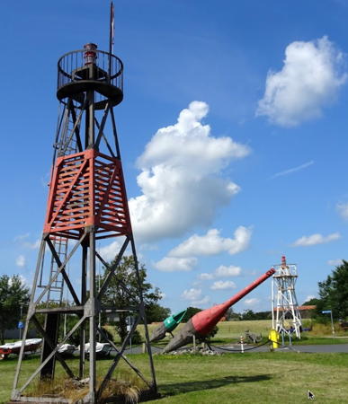
Date unknown. Inactive since 1980. 9 m (30 ft) square pyramidal skeletal tower, painted white. Andreas Köhler has a closeup photo, Werning's page has a photo, and Google has a satellite view. This light formerly stood on the island of Harriersand near the present Osterpater Range lights (see below). It has been relocated to the Weserstrand Sailing Club of Elsfleth. Located on the grounds of the club, across the parking lot from the Huntebake light (next entry). Site open, tower closed. Owner/site manager: Segelclub "Weserstrand" Elsfleth. ex-Admiralty B1298.2.
* Huntebake (relocated)
1915. Inactive since 1978. 11 m (36 ft) square pyramidal skeletal tower, painted black with a red horizontal band. Werning's page has a photo, Andreas Köhler has a closeup, and Google has a satellite view. This light formerly stood in the Weser near Elsfleth. It was first relocated to the WSA office in Oldenburg and in October 2003 it was donated to the Weserstrand Sailing Club of Elsfleth. Located on the grounds of the club. Site open, tower closed. Owner/site manager: Segelclub "Weserstrand" Elsfleth.
Warteplate Unterfeuer
Date unknown (1959?). Active; focal plane 14 m (46 ft); white light occulting once every 6 s, synchronized with the rear light. 14 m (46 ft) triangular pyramidal steel skeletal tower, mounted on a triangular concrete pier. The upper third of the tower is enclosed by a horizontally slatted daymark. Lighthouse painted white. Trabas has a photo by Capt. Peter, Werning's page has a photo, Andreas Köhler has a closeup photo, and Google has a satellite view. This range guides vessels bound upstream as they approach a sweeping left turn in the river. In 1999, the light was relocated 115 m (375 ft) downstream due to a change in the channel alignment. Located in the river just off the west bank near Elsfleth. Site and tower closed. Operator: WSA Weser-Jade-Nordsee. DE 317350; Admiralty B1299.79.
Soltplate Oberfeuer
1959. Active; focal plane 31 m (102 ft); white light occulting once every 6 s, synchronized with the front light. 31 m (102 ft) triangular pyramidal steel skeletal tower. Three of the tower's six sections are wrapped with a screened daymark. Lighthouse and daymark painted black. Trabas has Hartmann's closeup photo, Werning's page has a photo, Andreas Köhler has a view from the river, and Google has a satellite view. This tower carries the rear lights for both the upstream Warteplate and downstream Soltplate ranges. Located in trees just west of the Weser, about 1 km (0.6 mi) south of the Warteplate front light. Site status unknown. Operator: WSA Weser-Jade-Nordsee. DE 317351; Admiralty B1299.8.
 

HuNtebake (left) and Osterpater Lights, Elsfleth, July 2019
Google Maps photo by Andreas Köhler
 
Hohenzollern (Stempelsand-Soltplate) Unterfeuer
1898. Active; focal plane 14 m (46 ft); white light occulting once every 4 s, synchronized with the rear light. 15 m (49 ft) triangular skeletal tower with lantern, enclosed watch room, gallery, and partially enclosed central stairway. Lighthouse painted white. Trabas has a photo by Capt. Peter (also seen at right), Werning has a photo, Borchers has a photo, Andreas Köhler has a 2021 photo, and Google has a good satellite view. This lighthouse serves as the front light for both the upstream Stempelsand range and the downstream Soltplate range. Located on the west bank of the Weser south of Elsfleth. Site and tower closed. Operator: WSA Weser-Jade-Nordsee. ARLHS FED-325; DE 317352; Admiralty B1299.81.
Stempelsand Oberfeuer
1959. Active; focal plane 21 m (69 ft); white light occulting once every 4 s, synchronized with the front light. 21 m (69 ft) triangular pyramidal steel skeletal tower, painted black. Trabas has a photo by Capt. Peter, Werning's page has a photo, Andreas Köhler has a 2021 photo, and Google has a satellite view. The upper half of the tower is wrapped with a screened daymark. Lighthouse and daymark painted black. Located on the beach on the west bank of the Weser, 150 m (490 ft) south of the Hohenzollern front light. Site status unknown. Operator: WSA Weser-Jade-Nordsee. DE 317353; Admiralty B1301.81.

Lemwerder Area Lighthouses
Lemwerder is on the west bank of the Weser roughly halfway between Elsfleth and downtown Bremen.

*
Juliusplate Oberfeuer
1983. Active; focal plane 29 m (95 ft); white light occulting once every 4 s, synchronized with the front light. 32 m (105 ft) slender round cylindrical tower with a single gallery as topmark. Lighthouse painted red with one white horizontal band. Trabas has a good photo by Capt. Peter, Werning's page has a photo, and Google has a fine satellite view. This is the rear light of a downstream (northbound) range. The range replaced the Juliusplate leading light, which was relocated to a park in Bremen (see below). Located on the southwest side of the Weser opposite Farge, northwest of the ferry terminal. Site open, tower closed. Operator: WSA Weser-Jade-Nordsee. ARLHS FED-301; DE 317500; Admiralty B1302.41.
* Berne-Juliusplate Unterfeuer
1983. Active; focal plane 15 m (49 ft); white light occulting once every 4s (downstream) or every 6 s (upstream), synchronized with the rear lights. 14 m (46 ft) slender round cylindrical tower with a single gallery as topmark, mounted on a square concrete pier. Lighthouse painted red with one white horizontal band. Trabas has a closeup photo by Capt. Peter, Frank Stuke has a photo, Christine Strehl has a 2023 view from the river, and Google has a good satellite view. Located 490 m (0.3 mi) southeast of the Juliusplate Oberfeuer, in shallow water (often exposed) on the southwest side of the Weser a short walk on the beach from the Farge-Berne ferry terminal (highway 74). Site open, tower closed. Operator: WSA Weser-Jade-Nordsee. ARLHS FED-300; DE 317501; Admiralty B1302.4.

Hohenzollern Unterfeuer, Elsfleth
photo copyright Capt. Peter; used by permission
* Berne Oberfeuer
1983. Active; focal plane 22 m (72 ft); white light occulting once every 6 s, synchronized with the front light. 21 m (69 ft) slender round cylindrical tower with a single gallery as topmark, mounted on a square concrete pier. Lighthouse painted red with one white horizontal band. Trabas has a good photo by Capt. Peter, Werning's page has a photo, Ute Schapitz-Hagemann has a photo, and Google has a satellite view. Located 220 m (240 yd) southeast of the front light, in shallow water (often exposed) on the southwest side of the Weser. Site open, tower closed. Operator: WSA Weser-Jade-Nordsee. ARLHS FED-323; DE 317502; Admiralty B1302.39.
* Warfleth Oberfeuer (Warflether Sand, "Schwarzer Leuchtturm") (1)
1898. Inactive since 1985. 18 m (60 ft) square skeletal tower with lantern and gallery, painted black. Werning's photo is at right, Hartmann has a page for the lighthouse, Martin Ciomber has a closeup photo, Nicole Ba has a 2022 photo, and Google has a satellite view. This light was built originally at Farge; in 1954 it was relocated as the rear light of the Warfleth Range. The range was discontinued in 1985 and the front light was demolished. A local resident, Hans Röver, organized a preservation group that stepped in to stop demolition of this lighthouse. Located on a sandy peninsula, the Warflether Sand, on the southwest side of the Weser about 3 km (2 mi) southeast of the Berne lights; the peninsula is a protected natural area. Site open, tower closed. Owner/site manager: Schwarzer Leuchtturm Warfleth. ARLHS FED-328; ex-Admiralty B1302.81.
* Lemwerder Unterfeuer (2)
1983 (station established 1898). Active; focal plane 15 m (49 ft); white light occulting once every 4 s, synchronized with the rear light. 16 m (52 ft) slender round cylindrical tower with a single ring as topmark. Lighthouse painted red with one white horizontal band. Trabas has a closeup photo by Capt. Peter, Borchers has a photo, Werning's page has a photo, Emanuel Arnold has a 2022 photo, Willy Kaemena has a street view, and Google has a satellite view. This is the front light of an upstream range guiding ships into the harbor of Bremen. Located on the south bank of the Weser off Industriestraße in Lemwerder, just west of Bremen. Site open, tower closed. Operator: WSA Weser-Jade-Nordsee. ARLHS FED-135; DE 317560; Admiralty B1303.
Oberfeuer Warflether Sand
Oberfeuer Warflether Sand , Lemwerder
photo copyright Malte Werning; used by permission
* Lemwerder Oberfeuer (1)
1898. Inactive since 1983. 22.5 m (74 ft) triangular pyramidal skeletal tower with square central cylinder, lantern, gallery, and enclosed watch room. Entire lighthouse painted black. Werning has an excellent photo, Lothar Hemmelskamp has a 2021 closeup photo, and Google has a street view and a satellite view. This historic lighthouse was restored in 1992. Located on Niedersachsenstraße in Lemwerder, just west of Bremen. Site open, tower closed. Owner/site manager: Municipality of Lemwerder. ARLHS FED-136.
* Lemwerder Oberfeuer (2)
1983. Active; focal plane 26 m (85 ft); white light occulting once every 4 s, synchronized with the front light. 27 m (89 ft) slender round cylindrical tower with a single gallery as topmark. Lighthouse painted red with one white horizontal band. Trabas has a closeup photo by Ulrich Bode and Google has a street view and a satellite view. Located on Industriestraße at Vulkanstraße in Lemwerder, 430 m (0.25 mi) southeast of the front light. Site open, tower closed. Operator: WSA Weser-Jade-Nordsee. ARLHS FED-137; DE 317561; Admiralty B1303.1.

Bremen City Lighthouses

Bremen Harbor Lighthouses
The historic seaport of Bremen has a population of about 570,000 within the city limits and 2.4 million in the metropolitan area. Harbor and river tours provide the best views of Bremen area lighthouses.
* Seehausen West
Date unknown. Active; focal plane 14 m (46 ft); continuous green light. 14 m (46 ft) round cylindrical tower with lantern and gallery, painted green. Trabas has a closeup photo by Capt. Peter, Werning also has a good photo, Frank Stuke has a photo, Thorsten Aurin has a 2021 street view, and Google has a satellite view. Located on the south side of the Weser at the entrance to the Neustädter Hafen (New City Harbor) in Bremen. Accessible by a walk along the dike. Site open, tower closed. Operator: WSA Weser-Jade-Nordsee. ARLHS FED-326; DE 318060: Admiralty B1307.2.
Seehausen Ost
Date unknown. Active; focal plane 14 m (46 ft); red light occulting once every 3 s. 11 m (36 ft) round cylindrical tower with lantern and gallery, painted red, mounted on a square steel base. Jürgen Howaldt's photo is at right, Trabas has a good closeup photo by Capt. Peter, Dirk Heuer has a 2006 photo of the tower freshly painted, Werning has a photo, another photo is available, and Google has a satellite view. Located at the tip of the long east mole at the entrance to the Neustädter Hafen (New City Harbor) in Bremen. Site and tower closed, but there's a good view from the west light (previous entry). Operator: WSA Weser-Jade-Nordsee. ARLHS FED-327; DE 318050; Admiralty B1307.
* Juliusplate (relocated)
1913. Inactive since 1983. 12 m (39 ft) square pyramidal skeletal tower. Manuel García García has a photo and Google has a satellite view. This light was replaced by the Juliusplate Range Lights (see above0. Located in the Weseruferpark (Weser Bank Park) on the left (west) bank of the river in Bremen. Site open, tower closed. ex-Admiralty B1302.4.
Bremen Seehausen Ost
Bremen Seehausen Ost Light, Bremen, August 2009
Wikimedia Creative Commons photo by Jürgen Howaldt
* Tallship Alexander von Humboldt I (ex Lightship Reserve Sonderburg (Kiel III))
1906. Decommissioned 1986. 53.3 m (175 ft) steel lightship, converted to a fully-rigged 3-masted bark. The lightship served as a reserve ship in the North Sea until World War II; after the war it served the Kiel station until its deactivation. A serious collision with the Finnish MV Satu in 1957 knocked it off-duty for two years, and a second collision with the Liberian MV Ocean Wind in 1986 led to the ship being withdrawn from service. It was sold to Deutsche Stiftung Sail Training, a sail training institute in Bremerhaven, and converted to the 3-masted sailing ship Alexander von Humboldt. During the conversion, the ship's light tower was saved; it is on display at the Kieler Schifffahrtsmuseum in Kiel (see the Flensburg to Lübeck page). Beginning in 1988 the Alexander von Humboldt was one of the world's best-known tall ships, appearing in ports around the world. At the end of the 2011 season the ship was retired and sold. In 2012 it was based at Freeport, Bahamas, offering sailing tours. This business failed. After being overhauled during 2013 in Sevilla, Spain, the ship was sold again and renovated as a boutique hotel and event space. Thomas Breitkopf has a 2021 photo, Hartmann has a page for the lightship and Google has a street view and a satellite view of the ship moored on the east bank of the Weser in downtown Bremen. Owner/site manager: Alexander von Humboldt, das Schiff.
* Bremen Überseehafen Südmole (Mäuseturm, "Mouse Tower")
1906 (rebuilt 1928). Active; focal plane 14 m (46 ft); continuous green light. 12 m (40 ft) round cylindrical stone tower with lantern and two semicircular galleries. Lighthouse unpainted; lantern and gallery railings painted green. A photo is at the top of this page, Philipp Zurawski has a 2021 photo, Werning has a nice photo, Trabas has a photo by Capt. Peter, Matthias Melzer has a street view, and Google has a satellite view and a distant street view across the river. The lighthouse was heavily damaged by collision with a ship in April 1925; it was rebuilt using most of the original stones. Werning reports that in 2007 public access to the lighthouse was improved. Located at the end of the south mole at the entrance to the old harbor of Bremen; accessible by walking the mole. Site open, tower closed. Operator: WSA Weser-Jade-Nordsee. . ARLHS FED-041; DE 318150; Admiralty B1308.
Bremen Überseehafen Nordmole (Gitterbake, "Lattice Beacon")
1906. Active; focal plane about 14 m (46 ft); light characteristic unknown. Approx. 13 m (43 ft) square skeletal tower, painted red. The upper portion of the tower is enclosed by a metal daymark, also painted red. Trabas has a closeup photo by Capt. Peter, Werning has a photo, Wikimedia has several photos, a closeup street view is available, and Google has a satellite view and a closeup street view. Located at the south end of the detached mole. Accessible only by boat. Site open, tower closed. Operator: WSA Weser-Jade-Nordsee. . ARLHS FED-324; DE 318140; Admiralty B1307.8.
* Rekumerhull (relocated)
1931. Inactive since 1981. 8.7 m (29 ft) square pyramidal white skeletal tower. Manfred Gerlich has a 2020 photo and Google has a satellite view. The light was originally located on the west bank of the Weser at Elsfleth. In 1993 it was donated to the Rönnebecker Bürgerverein (Rönnebeck Citizens Association) and relocated to a waterfront park on the east side of the Weser in the Rönnebeck neighborhood of northwest Bremen. Site open, tower closed. ex-Admiralty B1302.2.

Gitterbake Light, Bremen, May 2017
Wikimedia Creative Commons photo by Ein Dahmer

Osterholz District (Weser East Bank) Lighthouses

Harriersand Lighthouses
Harriersand is a long island that stretches along the east side of the Weser for a distance of about 11 km (7 mi). The island is accessible by a bridge on the Inselstraße, a road leading west from Rade.

*
Osterpater Oberfeuer
1958. Active; focal plane 21 m (69 ft); white light, 2 s on, 2 s off. 19 m (62 ft) triangular skeletal tower, upper portion slatted, painted white. The tower also carries a red daymark at the top. Werning has a photo, Trabas has Ulrich Bode's photo, a closeup is available, and Google has a street view and a satellite view. This is an upstream (southbound) range. Located on the east bank of the Weser about 200 m (220 yd) south of the front light. Site open, tower closed. Operator: WSA Weser-Jade-Nordsee. DE 317201; Admiralty B1299.21.
* Osterpater Unterfeuer
1958. Active; focal plane 14 m (46 ft); white light, 2 s on, 2 s off. 12 m (39 ft) triangular skeletal tower, upper portion slatted, painted white. The tower also carries a red daymark at the top. Werning has a photo, Trabas has Capt. Peter's photo, and Google has a street view and a satellite view. Located on the east bank of the Weser in the southern part of Harriersand, opposite Käseberg. Site open, tower closed. Operator: WSA Weser-Jade-Nordsee. DE 317200; Admiralty B1299.2.
* Harriersand Unterfeuer
1898. Active; focal plane 11 m (36 ft); white light occulting once every 6 s, synchronized with the rear light. 11 m (36 ft) triangular skeletal tower with lantern, enclosed watch room, gallery, and partially enclosed central stairway. Lighthouse painted white, lantern dome green. Werning has a fine photo, Trabas also has a good closeup photo by Manfred Schüler, Rainer Berbalk has a 2021 photo, and Google has a street view and a satellite view. Located near the riverbank on the west side of Harriersand Island, 960 m (0.6 mi) south southwest of the rear light. Site open, tower closed. Operator: WSA Weser-Jade-Nordsee. ARLHS FED-098; DE 317240; Admiralty B1299.4.
* Großerpater Oberfeuer
1897. Active; focal plane 34 m (112 ft); white light occulting once every 4 s, synchronized with the front light. 36 m (118 ft) triangular pyramidal skeletal tower with central cylinder, lantern, gallery, and enclosed watch room. Lighthouse painted red with one white horizontal band; lantern dome is green. Werning has a photo, Trabas has Capt. Peter's closeup, Borchers has a photo, and Google has a satellite view and a distant street view. Located in a pasture near the center of Harriersand Island, 1320 m (0.82 mi) south of the front light. Site appears open, tower closed. Operator: WSA Weser-Jade-Nordsee. ARLHS FED-335; DE 316901; Admiralty B1288.1.
* Harriersand Oberfeuer
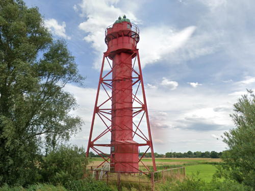
1898. Active; focal plane 22 m (72 ft); white light occulting once every 6 s, synchronized with the front light. 24 m (79 ft) triangular pyramidal skeletal tower with central cylinder, lantern, gallery, and enclosed watch room. Lighthouse painted red; lantern dome is green. A photo is at right, Werning has a nice winter photo, Trabas has a good closeup photo by Manfred Schüler, Borchers has a 2009 view, and Google has a street view and a satellite view. This is a downstream (northbound) range. Located im a pasture near the west side of Harriersand Island, about halfway between the two Großerpater lights. Site open, tower closed. Operator: WSA Weser-Jade-Nordsee. ARLHS FED-099; DE 317241; Admiralty B1299.41.
* Großerpater Unterfeuer
1897. Active; focal plane 14 m (46 ft); white light occulting once every 4 s, synchronized with the rear light. 15 m (49 ft) triangular skeletal tower with lantern, enclosed watch room, gallery, and partially enclosed central stairway. Lighthouse painted white, lantern dome green. Werning's page for this lighthouse has a good photo and a useful list of the lighthouses built of this design. Trabas also has a good photo by Capt. Peter, and Google has a satellite view. This is an upstream (southbound) range guiding ships past Sandstedt. Located near the center of the north end of Harriersand. Site open, tower closed; the island is accessible by passenger ferry from Brake on the west bank or by a bridge from Rade to the southeast. Operator: WSA Weser-Jade-Nordsee. ARLHS FED-334; DE 316900; Admiralty B1288.

Harriersand Oberfeuer, Harriersand, August 2013
Google maps photo by Salinos D.

Southern Cuxhaven District Lighthouses

Sandstedt Lighthouses
* Sandstedt Unterfeuer (2)
1981 (station established 1898). Active; focal plane 15 m (49 ft); white light occulting once every 6 s, synchronized with the rear light. 17 m (56 ft) slender round cylindrical tower with a large octagonal pyramidal topmark. Tower painted white, topmark red. The light is displayed from a tiny window in the middle of the topmark. Werning has a closeup, Trabas has a good photo by Ulrich Bode, Thorsten Aurin has a 2021 photo, M. Gieschler has a 2008 photo, and Google has a satellite view and a street view from the riverbank. This is a downstream (northbound) range. The original lighthouse was relocated to the Deutsches Schiffahrtsmuseum in Bremerhaven (see the Bremerhaven page). Located on the riverbank on the east side of the Weser south of the village of Sandstedt. Site open, tower closed. Operator: WSA Weser-Jade-Nordsee. ARLHS FED-205; DE 317020; Admiralty B1297.
* Sandstedt Oberfeuer (2)
1981 (station established 1898). Active; focal plane 23 m (75 ft); white light occulting once every 6 s, synchronized with the front light. 35 m (115 ft) slender round cylindrical tower with a large octagonal funnel-shaped topmark. Tower painted white, topmark red. The light is displayed from a tiny window below the topmark. Trabas has a good photo by Ulrich Bode (note the original lighthouse in the background), Werning has a good photo, Udo Borchers has a 2009 photo, and Google has a street view and a satellite view. Located in a field 420 m (0.25 mi) north northeast of the front range light and about 300 m (0.2 mi) southeast of the old rear range light, west of the village of Sandstedt. Site open, tower closed. Operator: WSA Weser-Jade-Nordsee. ARLHS FED-206; DE 317021; Admiralty B1297.1.
* Sandstedt Oberfeuer (1)
1898. Inactive since 1981. Approx. 25 m (82 ft) triangular pyramidal cast iron skeletal tower with central cylinder, enclosed watch room, lantern and gallery. Lighthouse painted red; lantern dome is green. Werning has a good photo, Andreas Köhler has a 2022 closeup, Udo Borchers has a 2009 closeup, Robert Borm has a photo, Huelse also has a photo of the light, and Google has the street view seen at right and a satellite view. Located beside the K53 highway about 700 m (0.4 mi) east of the Brake-Sandstedt ferry terminal. Site open, tower closed. Owner/site manager: unknown. ARLHS FED-314.

1898 Sandstedt Oberfeuer, Sandstedt, July 2023
Google Maps street view

Information available on lost lighthouses:

Notable faux lighthouses:

Adjoining page: North: Bremerhaven | West: Borkum to Wilhelmshaven

Return to the Lighthouse Directory index | Ratings key

Posted February 26, 2005. Checked and revised December 31, 2023. Lighthouses: 37, lightships: 1. Site copyright 2023 Russ Rowlett and the University of North Carolina at Chapel Hill.