Lighthouses of the Philippines: Samar

The Republic of the Philippines (Pilipinas in Filipino) includes more than 7600 islands stretching over 1750 km (1100 mi) of the western Pacific and separating the Philippine Sea on the east from the South China Sea on the west. The largest islands are Luzon at the northern end of the country and Mindanao at the southern end. As of 2020 the population of the country was about 109 million.

The archipelago was a Spanish colony until the Spanish-American War of 1898, which brought the islands under U.S. administration. Japan occupied the islands during World War II (1942-45) and the country became independent shortly thereafter (1946).

The country is divided into 17 regions and subdivided into 81 provinces. This page lists lighthouses in the island of Samar, part of the Eastern Visayas Region in the eastern part of the Phillipines. The third largest island of the Philippines, Samar has a population of about 1.9 million. The north and east coasts of the island face the open Philippine Sea. The south coast faces Leyte Gulf and the west coast faces the Samar Sea. At its northwestern corner Samar is separated from Luzon by the crucial San Bernardino Strait, the only passage from the Pacific Ocean into the central Philippines; in the southwest it is separated from Leyte by the narrow San Juanico Strait, crossed by a bridge since 1973.

Formerly a single province, Samar was divided in 1963 into the three provinces of Northern Samar, Eastern Samar and (Western) Samar.

Filipino and English are official languages in the Philippines. In Filipino a lighthouses is called a parola; an island is an isla or pulo. Many English maritime terms have been adopted into Filipino, including cape, bay, and port, and the names of historic lighthouses are often retained in their Spanish forms.

Lighthouses in the Philippines are maintained by the Marine Safety Services Command of the Philippine Coast Guard. Notices to Mariners are posted by the National Mapping and Resource Information Agency (NAMRIA).

Many Philippine lighthouses are not well known so better information and photos are always needed.

ARLHS numbers are from the ARLHS World List of Lights. PCG numbers are the Philippines Light List numbers, where known. Admiralty numbers are from volume F of the Admiralty List of Lights & Fog Signals. U.S. NGA List numbers are from Publication 112.

General Sources
Lighthouses in the Philippines
Photos and observations in blog entries by Loyd Martinez.
Online List of Lights - Philippines
Photos by various photographers posted by Alexander Trabas.
Lighthouses in the Philippines
Wikipedia article with links to articles on several of the individual lighthouses.
Spanish Lighthouses of the Philippines
This is the Directory's own list of the Spanish light stations with notes on their current status.
Lighthouses in the Philippines
Photos by various photographers available from Wikimedia.
World of Lighthouses - Philippines
Photos by various photographers available from Lightphotos.net.
Navionics Charts
Navigational chart for Samar.


Capul Island Light, Samar, November 2021
Capul Tourism Office photo
Northern Samar Province Lighthouses

Northwest Coast (San Bernardino Strait) Lighthouses
* Capul Island
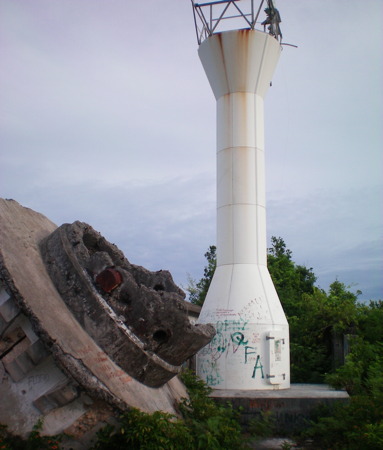
1896 (Spanish: Guillermo Brockman). Active; focal plane 43 m (142 ft); white flash every 7 s. 12 m (39 ft) round granite block tower with gallery, painted white with red trim. Lantern removed. The keeper's houses are in ruins. Japanese gun emplacements nearby. A photo is at the top of this page, Darwin Dalisay's photo shows the keeper's house, a 2021 closeup photo is available, Jonathan Amaranto has a 2022 photo, the lighthouse appears on a postage stamp, and Google has a satellite view of the station. Manuel Noche found the light station to be in "deplorable" condition around 2000 but the tower had been restored by 2006. The other station buildings were still collapsing as of 2015 but a new station building has been built since then. A 2018 photo by Mel Grace Cula shows some work in progress on the lighthouse with the new station building in the background and a 2019 photo by Mark David Lagrimas shows the completed station. This is now a staffed Coast Guard station. Capul is a small but inhabited island off the northwestern tip of Samar; it has a population of about 12,500. Located at the northern tip of the island facing the narrowest passage of the San Bernardino Strait, only 7 km (4 mi) wide at this point. The island, site of a 16th century Spanish mission, is accessible by passenger ferry from Allen in northwestern Samar. Site open, tower closed. . ARLHS PHI-045; PCG-0199; Admiralty F2492; NGA 14152.
* Allen (2)
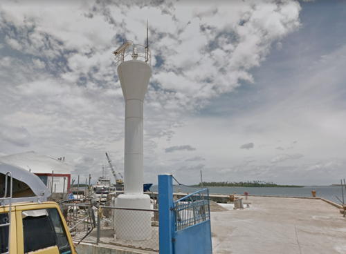
Date unknown. Active; focal plane 12.5 m (41 ft) (?); white flash every 5 s. 10 m (33 ft) round barbell-shaped white fiberglass tower. Lightphotos.net has a view from the sea, Google has a street view, and Bing has a distant satellite view. Wikipedia has a November 2012 photo showing a square skeletal tower about 15 m (49 ft) tall; this tower is on the ferry wharf and it's not clear if it carries a light. Allen, near the northwestern corner of Samar, is the terminal for ferries linking Samar to Matnog, Luzon, providing a key link in the Pan-Philippine Highway. Located at the Coast Guard station in the fishing port of Allen, about 300 m (330 yd) south of the ferry wharf. Site open, tower closed. Admiralty F2474; NGA 14988.

North Coast (Philippine Sea) Lighthouses
Tinau (Tingiao) Island
Date unknown. Active; focal plane 10 m (33 ft); red flash every 5 s. 9 m (30 ft) square white concrete tower with four buttresses and an external stairway spiraling around the tower. No photo available but Bing has a fuzzy satellite view. Located in the village of Apis at the southeast corner of Tingiao, an island off the northwestern coast of Samar. Site open, tower closed. Admiralty F2480; NGA 15000.
* San José (Carangian)
Date unknown. Active; focal plane 13 m (43 ft); green flash every 10 s. 10 m (33 ft) round barbell-shaped white fiberglass tower. Lightphotos.net has a photo and Google has the closeup street view at right and an indistinct satellite view. Located on the waterfront of San José, a fishing town on Samar's north coast. Site open, tower closed. PCG-0287; Admiralty F2482; NGA 14992.
* Catarman
Date unknown. Active; focal plane 11 m (36 ft); continuous red light. 10 m (33 ft) square concrete pillar with a buttressed base. David Hyde has a photo and a view from the sea and the small light is barely visible on the beach in Google's satellite view. Located at the mouth of the Catarman River in Catarman on the central north coast of Samar. Site open, tower closed. Admiralty F2484; NGA 14984.
Port Laoang
Date unknown. Active; focal plane unknown; red flash every 5 s. No description available. No photo available and the light has not been found in Google's satellite view of the harbor. Located in Laoang, a city of about 60,000 residents at the head of Laoang Bay. Site status unknown. Admiralty F2447; NGA 14997.
Laoang (Ipil Point)
Date unknown. Active; focal plane about 10 m (33 ft); red flash every 5 s. Approx. 10 m (33 ft) tower, probably barbell-shaped. No photo available but Google has an indistinct satellite view. The light color was changed from white to red in 2015. Located on a forested promontory on the west side of Laoang (Lango) Island at the entrance to Laoang Bay. Site status unknown. Admiralty F2446; NGA 14996.

San José Light, Northern Samar, August 2016
Google Maps street view
* Batag Island (1)
1907 (U.S.). Apparently inactive but listed with focal plane 95 m (312 ft); white flash every 5 s. 31 m (101 ft) round cylindrical concrete tower with double gallery, unpainted. The accompanying keeper's houses are in ruins. Loyd's blog has a page with photos taken on a visit in March 2015 (one of these photos is at right), another blog has closeup photos (about 3/4 the way down the page) taken in 2006, a 2023 photo is available, and Google has a satellite view. Built early in the U.S. occupation, this historic tower marks the northeastern corner of Samar and the southern entrance to San Bernardino Strait. The lighthouse is a sibling of the much better known Cape Bolinao Light in northern Luzon. Intended as a landfall light, it is at least 2 km (1.25 mi) from the sea. The Philippines Coast Guard announced reactivation of the Batag Island Light in November 2016 and the description given is of the historic lighthouse. There is no evidence confirming this reactivation. Bunny Mendoza's May 2016 photo shows the tower cleaned but it still seems abandoned in Chenny Ge's 2019 photo. Located on Batag Island about 20 km (12.5 mi) northeast of Laoang. Accessible only by boat, but ferry service to the island from Laoang is available. Site open, tower reported open but dangerous. . ARLHS PHI-010; PCG-0290; Admiralty F2448; NGA 15004.
#Batag Island (2)
2000 (station established 1907). Destroyed by Typhoon Milenyo (also called Typhoon Xangsane) in September 2006. Approx. 20 m (66 ft) round cylindrical tower. Joni Bonifacio has a photo taken in April 2006. The light was not replaced following the typhoon. Formerly located near the historic lighthouse. Site open.
Sila Point
Date unknown. Active; focal plane unknown; white flash every 10 s. Approx. 10 m (33 ft) round barbell-shaped white fiberglass tower. No photo available but Bing has a distant satellite view. Located on a prominent cape about 40 km (25 mi) southeast of Batag Island. Accessible only by boat. Site status unknown; this is a very remote location. Admiralty F2448.5; NGA 15005.

Batag Island Light, Laoang, March 2015
photo copyright Loyd Martinez; used by permission

Eastern Samar Province Lighthouses

East Coast (Philippine Sea) Lighthouses
Hiunatungan Island (Arteche)
Date unknown. Active; focal plane unknown; red flash every 5 s. Approx. 10 m (33 ft) round barbell-shaped white fiberglass tower. No photo available but Google has a distant satellite view. Located on an island in the entrance to Arteche, a village at the northern edge of Eastern Samar Province. Accessible only by boat. Site open, tower closed. Admiralty F2448.3; NGA 15005.5.
Linao Island
Date unknown. Active; focal plane unknown; white flash every 10 s. No description available. No photo available and the light has not been found in Google's satellite view of the island. Linao is one of a chain of small islands off Bankari Point, a prominent cape on northwest Samar. Accessible only by boat. Site status unknown. Admiralty F2449; NGA 15006.
* Borongan
Date unknown. Active; focal plane 11 m (36 ft); white flash every 5 s. 7 m (23 ft) hexagonal metal tower with gallery. Entire lighthouse is white. A 2016 Google street view is seen at right and Google also has a 2019 street view, but the light is hard to see in Google's satellite view. Located at the Coast Guard station across the street from the beach just south of the Circumferential Road in Borongan, the provincial capital and a city of about 72,000 residents. Site open, tower closed. Admiralty F2452; NGA 15008.
Divinubo Island
1906 (U.S.). Reactivated; focal plane 41 m (136 ft); white flash every 5 s. 14 m (46 ft) square white concrete tower with four buttresses and an external stairway spiraling around the tower. Abandoned keeper's cottage. Lloyd Bermas has a 2022 photo, Nickle Canete has a 2017 photo, Davejames Moratal has a 2018 photo, a 2014 closeup is available, and Google has a distant satellite view of the station. This light was abandoned for many years. Apparently it was restored and relighted in 2013; Nature Watch of Eastern Samar has a posting dated October 2013 that describes the light as "electrically lighted and enclosed in thick glass. It beams a bright light every 15 seconds." Located on a small island southeast of Borongan, the capital of Eastern Samar, marking the entrance to the harbor of that city. Accessible by a hiking trail. Site open, and the tower can be climbed. ARLHS PHI-082; PCG-0294; Admiralty F2450; NGA 15012.
Tugnug Point
Date unknown. Active; focal plane unknown; white flash every 5 s. Approx. 10 m (33 ft) round barbell-shaped white fiberglass tower. No photo available but Bing has a distant satellite view. A natural arch at the nearby Ginduyanan Cove is well known. NGA calls the location Tugnung Point. Located atop steep bluffs about 25 km (15 mi) northeast of the village of General MacArthur. Site status unknown. Admiralty F2452.5; NGA 15014.

Borongan Light, Eastern Samar, December 2016
Google Maps street view
** Suluan Island (2)
Date unknown (station established 1909). Active; focal plane 138 m (452 ft); three white flashes every 15 s. 16 m (52 ft) round hourglass-shaped metal tower, painted white. The 1-story keeper's house is abandoned. Arriane Lacoste's photo is at right and Google has an indistinct satellite view. There are also ruins of the original lighthouse, which was destroyed by the U.S. Army's 6th Ranger Battalion in a raid on the Japanese garrison here on 17 October 1944, a skirmish several days prior to General Douglas MacArthur's famous landing on Leyte. This lighthouse marks the northern entrance to Leyte Gulf off the southeastern corner of Samar. Suluan is also the first landing place of Ferdinand Magellan's round-the-world expedition in March 1521. Located at the highest point of the island about 40 km (25 mi) southeast of Guiuan. Accessible only by boat; and a hiking trail; transportation from Guiuan is available. Site open, tower apparently open for climbing. ARLHS PHI-060; PCG-0297; Admiralty F2454; NGA 15020.

South Coast (Leyte Gulf) Lighthouses
Leyte Gulf is a wedge-shaped extension of the Philiipine Sea bounded by Samar to the north and Leyte to the west. On the south the Surigao Strait connects the Gulf to the Bohol Sea, and on the north the narrow San Juanico Strait leads to the Samar Sea.

* Guiuan (1)
Date unknown. Inactive since 2013. Light mounted on the "spire" (actually the bell tower) of a church in Guiuan. The historic Guiuan Church of the Immaculate Conception was largely destroyed by Typhoon Yolanda (also called Typhoon Haiyan) in November 2013. Google's January 2017 street view shows that the tower was still standing and was under repair. No light is visible in Edgar Alan Yap's 2019 photo of the tower. Bing has an indistinct satellite view. Meanwhile PCG reported the light reactivated (focal plane unknown; white flash every 5 s) in September 2016; almost certainly this was on a new tower not yet located. Located in Guiuan, an important fishing port of about 55,000 residents on Samar's southeastern peninsula. Site open, tower status unknown. Active light: PCG-0296; Admiralty F2453; NGA 15016.
Manicani Island
Date unknown. Active; focal plane unknown; white flash every 15 s. Approx. 10 m (33 ft) white fiberglass tower. No photo available and the light has not been found in Google's satellite view. This light marks the beginning of the approach through reefs to Guiuan. Located on an inhabited island off Samar's southeastern peninsula. Site status unknown. PCG-0461; Admiralty F2453.5.
Balangiga (Lucson Point)
Date unknown. Active; focal plane unknown; white flash every 10 s. Approx. 10 m (33 ft) tower. No photo available but Bing has a satellite view. Located on a promontory on the west side of Balangiga, a town on the central north shore of Leyte Gulf. Site status unknown. PCG-0852; Admiralty F2456.5.

Suluan Island Light, Eastern Samar, August 2008
ex-Panoramio photo copyright Arriane Lacoste; permission requested

Samar Province Lighthouses

Southwest Coast (Leyte Gulf) Lighthouses
Mariquitdaquit Island
Date unknown. Active; focal plane 18 m (59 ft); white flash every 4 s. 10 m (33 ft) concrete post with a buttressed base. A view from the sea is available and Bing has an indistinct satellite view of the dark tower. Located on a small island placed dangerously in the entrance to San Pedro and San Paulo Bay, which separates southern Samar from Leyte. Accessible only by boat. Site open, tower closed. Admiralty F2456; NGA 14924.
Jinamoc Island
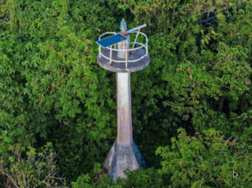
Date unknown. Active; focal plane 24 m (79 ft); two white flashes every 10 s. 9 m (30 ft) white concrete post with a buttressed base and gallery. Keeper's house and other station buildings. Mark Joseph Delmo has the 2023 drone view seen at right, and Google has only a fuzzy satellite view of the station. This light acts as a leading light guiding northbound vessels approaching the narrow San Juanico Strait separating Leyte from Samar. as well as southbound vessels leaving the strait. Located on the southwest side of Jinamoc Island, about 2 km (1.25 mi) south of Basey, Samar, and 7 km (4.5 mi) east of Tacloban, the capital of Leyte. Accessible only by boat. Site status unknown. Admiralty F2458; NGA 14920.

Northwest Coast (Samar Sea) Lighthouses
The Samar Sea is a relatively small sea bordering Samar to the east, Masbate to the west, and Leyte to the south. It is connected to the Philippine Sea to the northeast by the San Bernardino Strait, to Leyte Gulf to the southeast by the San Juanico Strait, to the Visayan Sea to the southwest and to the Sibuyan Sea to the northwest.

Santa Rita
Date unknown. Active; focal plane at least 16 m (52 ft); white flash every 5 s. No description and no photo available and the light is not seen in Bing's satellite view. This light guides ships to the northern entrance of the San Juanico Strait. It has a listed range of 15 nautical miles (28 km, 17 mi). Located on the densely forested Santa Rita Island on the north side of the channel entering the strait from the north. Accessible only by boat. Site status unknown. Admiralty F2423.5; NGA 14912.

Jinamoc Island Light, Basey, February 2023
Google Maps photo by Mark Joseph Delmo
Daram (Danao-Danaoan Island)
Date unknown. Active; focal plane unknown; white flash every 5 s. Approx. 10 m (33 ft) barbell-shaped white fiberglass tower. No photo available but Bing has a distant satellite view. Located on heights at the northwest end of Danao-Danaoan Island, a small island off the northwestern tip of the much larger Daram Island. Accessible only by boat. Site status unknown. Admiralty F2465; NGA 15022.
Uacuac Island (Calbiga River)
Date unknown. Active; focal plane 11.5 m (37 ft); white flash every 5 s. 10 m (33 ft) white concrete post, probably with a stairway spiraling around the tower. No photo available but Bing has a distant satellite view. This light is on a low point of land separating two inlets of the Samar Sea, Villareal Bay to the south and Maqueda Bay to the north. Located in forest on the north side of the mouth of the Calbiga River. Site status unknown. Admiralty F2462; NGA 15024.
* Catbalogan
Date unknown. Active; focal plane 30.5 m (100 ft); red flash every 5 s. 7.5 m (25 ft) white concrete post. Lui Acuna's photo is at right, Jim Carl Maasin has a closeup photo, Google has a street view, and Bing has a fuzzy satellite view. Located on a steep hill on the north side of Catbalogan, the provincial capital and a city of more than 100,000 residents on the west coast of Samar. Site status unknown. Admiralty F2464; NGA 15028.
Gandara River
Date unknown. Active; focal plane 10 m (33 ft); red flash every 5 s. 9 m (30 ft) barbell-shaped white fiberglass tower. Josephos Gadaingan has a 2023 photo and Bing has a satellite view. Located on the south side of the entrance to the Gandara River, which leads to the small port of Pagsanjan. Accessible only by boat. Site status unknown. Admiralty F2470; NGA 15032.
Calbayog
Date unknown. Active; focal plane about 16 m (52 ft); red flash every 5 s. Mast atop a 10 m (33 ft) round white concrete tower. Google has a street view across the river but the tower is not seen in Google's fuzzy satellite view. The mast has been added to maintain visibility of the light in a crowded urban setting. Calbayog is a city with nearly 190,000 residents; it has nearly a fourth of the population of Samar Province. Located somewhere on the waterfront of Calbayog, at the mouth of the Calbayog River. Site status unknown. Admiralty F2472; NGA 15044.

Catbalogan Light, Catbalogan, March 2017
Google Maps photo by Lui Acuna
* Malaga
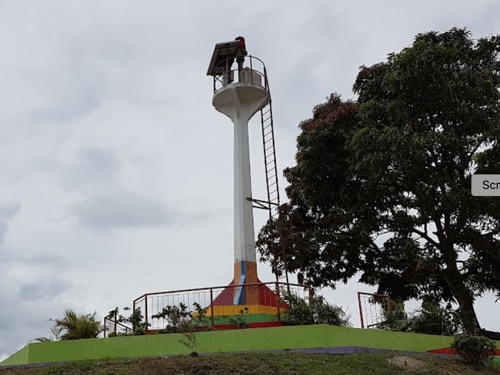
Date unknown. Active; focal plane unknown; white flash every 5 s. 9.5 m (31 ft) round barbell-shaped white fiberglass tower. A photo is at right, Google has a street view, and Bing has a satellite view. Located on the waterfront of Malaga, a village near the northern end of the Calbayog municipality. Site open, tower closed. Admiralty F2473; NGA 15037.

Samar Sea Islands Lighthouses
These are islands of volcanic origin in the middle of the Samar Sea, halfway between Samar and Masbate.

Santo Niño
Date unknown. Active; focal plane unknown; white flash every 5 s. Approx. 9 m (30 ft) white fiberglass tower. No photo available but Google has a distant satellite view. Located on heights at the eastern tip of Santo Niño (Limbangcavayan) Island, about 25 km (15 mi) southwest of Calbayog. Accessible only by boat. Site status unknown. Admiralty F2468; NGA 15034.
Cabilison Island (Almagro)
Date unknown (1930s?) (U.S.). Active; focal plane 70 m (230 ft); white flash every 5 s. 10 m (33 ft) white metal tower. Keeper's house and other station buildings. No photo available but Google has a satellite view of the station. Almagro is an inhabited island in the southern part of the Samar Sea, between Samar and southern Masbate. Located at the highest point of Cabilison Island, a small uninhabited island off the southwestern tip of Almagro. Accessible only by boat. Site status unknown. ARLHS PHI-011; PCG-0198; Admiralty F2466; NGA 15036.
Tagapul-an (Tagapula Island)
Date unknown. Active; focal plane unknown; white flash every 5 s (?). Approx. 10 m (33 ft) round barbell-shaped white fiberglass tower. No photo available but Google has a satellite view. Tagapul-an is the northernmost of the islands in the Samar Sea. Located atop a steep bluff on the northwestern point of the island. Site status unknown. Admiralty F2467.

Malaga Light, Calbayog, undated
Facebook photo by Calbayog City

Information available on lost lighthouses:

Notable faux lighthouses:

Adjoining pages: Southwest: Leyte and Biliran | West: Masbate| Northwest: Southeast Luzon

Return to the Lighthouse Directory index | Ratings key

Posted July 24, 2005. Checked and revised November 11, 2023. Lighthouses: 30. Site copyright 2023 Russ Rowlett and the University of North Carolina at Chapel Hill.