Lighthouses of Russia: Northern Kola Peninsula

Russia (Россия, Rossiya in Russian) is by far the world's largest country, spanning a little over 150° in longitude. It is organized as the Russian Federation (Rossiyskaya Federatsiya) with members known as federal subjects (sub'yekty federatsii). Russia is primarily a continental nation but it has important coastlines on the Baltic, Black, and Caspian Seas and very long coastlines on the Arctic Ocean and North Pacific Ocean. To guard these coasts it operates hundreds of lighthouses, many of them historic.

The northwestern corner of Russia lies on the Barents Sea, an arm of the Arctic Ocean. The broad, southeastward-pointing Kola Peninsula (Kolskiy Poluostrov) separates the Barents Sea from the nearly-enclosed White Sea, which extends southward more than 500 km (300 mi). The entire Kola Peninsula is governed as part of Murmansk Oblast (province), one of the 85 federal subjects. This page lists the lighthouses of the Kolsky and Lovozersky Districts of the oblast, including the northern (Barents Sea) and eastern (White Sea Throat) coasts of the peninsula.

The Russian word for a lighthouse is mayak (маяк); ostrov is an island, mys is a cape, bukhta or guba is a bay, zaliv is a larger bay or gulf, proliv is a strait, reka is a river, and gavan' is a harbor.

Russian lighthouses are owned by the Russian Navy and maintained by the Navy's Office of Navigation and Oceanography (Управление навигации и океанографии).

ARLHS numbers are from the ARLHS World List of Lights. Admiralty numbers are from volume L of the Admiralty List of Lights & Fog Signals. Russian light list (RU) numbers are from Russian Navy Publication 2103 for the Barents Sea and 2105 for the White Sea, as reported by the Admiralty. U.S. NGA numbers are from Publication 115. The Russian light list, Огни и знаки (Lights and Signs), is not available online.

General Sources
Online List of Lights - Russia - Arctic Sea Coast
Coming soon: photos by various photographers posted by Alexander Trabas.
Lighthouses in Murmansk Oblast
Photos by various photographers available from Wikimedia.
World of Lighthouses - Arctic Coast of Russia
Photos by various photographers available from Lightphotos.net.
Russische Leuchttürme auf historischen Postkarten
Historic postcard images posted by Klaus Huelse.
Kildin island North Light
Kil'din Island North Light, July 2008
photo copyright EDM, courtesy of Yarman Yan

Kolsky District Lighthouses

Kil'din Island Area Lighthouses
Kil'din Island (Ostrov Kil'din) is just off the Barents Sea coast about 25 km (15 mi) east of Mys Letinsky. The roughly elliptical island is about 16 km (10 mi) long and 6 km (3.5 mi) wide. There is no permanent population, and due to military installations travel to the island is restricted.

Kil'dinskiy Zapadnyy (Kil'din Island West) (2)
2006 (station establishment date unknown) . Active; focal plane 25 m (82 ft); yellow light, 2 s on, 2 s off. 5 m (17 ft) square pyramidal tower, painted white with a red vertical stripe on each face. The lighthouse has been restored by the EDM Company. A photo is available and Bing has a satellite view. This lighthouse is built near the southwest corner of Ostrov Kil'din (Kil'din Island) marking the western entrance to the strait between the island and the mainland. Site status unknown. ARLHS ERU-098; Admiralty L6403.8 (ex-L6414); RU 2103-0810; NGA 15288.
Kil'dinskiy Severnyy (Kil'din Island North)
Date unknown. Active; focal plane 84 m (276 ft); white flash every 6 s. 19 m (62 ft) round concrete tower with lantern and gallery, painted with red and white horizontal bands. The lighthouse has been restored by the EDM Company, as seen in the 2008 photo at the top of this page. Lightphotos.net has a second photo and Oleg Perov's view from the sea, and Bing has a satellite view. The lighthouse is built on the north side of Ostrov Kil'din (Kil'din Island) about 25 km (15 mi) east of the entrance to Kola Bay. Site status unknown. ARLHS ERU-041; Admiralty L6404; RU 2103-0795; NGA 15292.
Sunduki
Date unknown. Inactive. 28 m (92 ft) square skeletal tower, painted black. No photo available but Bing has a satellite view. This tower is listed by ARLHS and the Russian Lighthouse Award pages, but it does not appear on international light lists. Located at the northeastern point of Kil'din Island. Site open, tower closed. ARLHS ERU-123.
Kil'dinskiy Vostochnyy (Kil'din Island East)
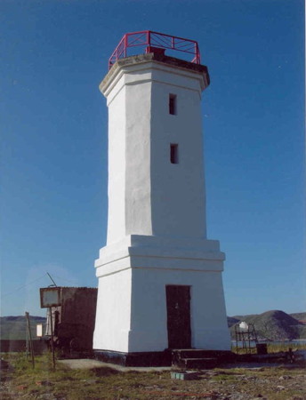
Date unknown. Active; focal plane 19 m (62 ft); red or green light, depending on direction, 1.5 s on, 4.5 s off. 10 m (33 ft) octagonal cylindrical concrete tower with gallery but no lantern, mounted on a square concrete base. The lighthouse is unpainted white concrete; gallery rail is red. The lighthouse was restored and repainted by the EDM Company in 2004. Yarman Yan posted the photo at right, Lightphotos.net has Valeriy Lyushkov's photo and view from the sea, Sergey Sotnikov has a distant view, Anna Denisenko has a 2021 distant view, and Bing has a satellite view. Located on the southeastern side of Ostrov Kil'din (Kil'din Island) a short distance east of the settlement of Vostochny (East) Kil'din. Site status unknown. ARLHS ERU-042; Admiralty L6408; RU 2103-0850; NGA 15308.
Mys Mogil'nyy
Date unknown. Active; focal plane about 10 m (33 ft); light characteristic unknown. Approx. 8 m (26 ft) square cylindrical tower. No photo available but Bing has a satellite view. Located on a low cape about 800 m (1/2 mi) west of the Kil'dinskiy Vostochnyy lighthouse. Site status unknown. Admiralty L6415.5.
Mys Prigonnyy
Date unknown. Active; focal plane 8 m (26 ft); red flash every 4 s. 4 m (13 ft) square pyramidal white concrete tower. Lightphotos.net has Valeriy Lyushkov's photo and Bing has a satellite view. Located on a sharp point of land on the south side of Kil'din Island, marking the narrowest point of the passage between the island and the mainland. Site status unknown. Admiralty L6416; RU 2103-0835.
Malyy Kil'dinskiy
Date unknown. Active; focal plane 13 m (43 ft); white flash every 6 s. 4 m (13 ft) round cylindrical concrete tower painted red. Lightphotos.net has Valeriy Lyushkov's photo and Bing has an indistinct satellite view. Located on a small island off the mainland coast about 1 km (0.6 mi) southwest of Mys Prigonnyy. Accessible only by boat. Site status unknown. Admiralty L6416.6.
Kildin East Light
Kil'din Island East Light, 2005
photo copyright EDM, courtesy of Yarman Yan
Zarubikha
Date unknown. Active; focal plane 28 m (92 ft); flash every 3 s, red or green depending on direction. 4 m (13 ft) yellow square pyramidal tower. Lightphotos.net has Valeriy Lyushkov's photo and a Bing satellite view probably shows the shadow of the light. Located on a headland of the mainland opposite Kil'din Island, helping to mark the narrowest point of the passage between the island and the mainland. Site status unknown. Admiralty L6417.5; RU 2103-0840; NGA 15309.
Zarubikha Vostochnyy (Zarubikha East)
Date unknown. Active; focal plane 28 m (92 ft); yellow flash every 3 s. 4 m (13 ft) yellow square pyramidal tower. Lightphotos.net has Valeriy Lyushkov's photo and Bing has an indistinct satellite view. Located on a headland of the mainland opposite Kil'din Island, marking a narrow point of the passage between the island and the mainland. Site status unknown. Admiralty L6417.8; RU 2103-0843; NGA 15310.
Mys Chevray
Date unknown. Active; focal plane 18 m (59 ft); white flash every 2.5 s. 9 m (30 ft) square wood pyramidal skeletal tower, covered by a slatted wood daymark painted red with a white diagonal stripe on each face. The EDM Company also restored this lighthouse. Lightphotos.net has Valeriy Lyushkov's photo and Bing has a distant satellite view. Located on a cape of the mainland opposite the eastern end of Kil'din Island. Site status unknown. ARLHS ERU-087; Admiralty L6418; RU 2103-0855; NGA 15312.
Ostrov Malyy Oleniy
Date unknown. Active; focal plane 28 m (92 ft); white flash every 5 s. 7 m (23 ft) square pyramidal tower painted white with a black top. Lightphotos.net has Valeriy Lyushkov's view from the sea and Bing has a satellite view. Malyy Oleniy is a narrow island about 8 km (5 mi) long and about 13 km (8 mi) southeast of Ostrov Kil'din. Located on the eastern tip of the island. Accessible only by boat. Site status unknown. ARLHS ERU-105; Admiralty L6426; RU 2103-0860; NGA 15324.

Teriberka Area Lighthouses
Founded in the 1860s, the historic fishing port of Teriberka is one of the oldest Russian settlements on the Barents Sea coast.

Mys Zhiloy
Date unknown. Active; focal plane and light characteristic unknown. Approx. 6 m (20 ft) square pyramidal tower. Andrey Skorodumov has a distant view and Google has a satellite view. Located on a headland at the west side of the entrance to a bay leading to the settlement of Teriberka. Site status unknown. Admiralty L6442.
Lodeynyy
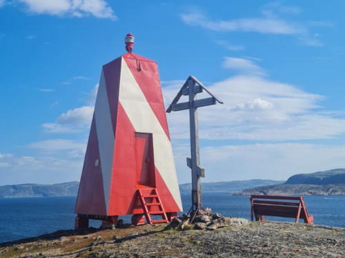
Date unknown. Active; focal plane unknown; white light, pattern unknown. 6 m (20 ft) square pyramidal tower painted with red and white diagonal bands. A closeup photo is at right and Google has a satellite view of the location. Located on a steep headland on the south side of the entrance to Teriberka harbor. Site open, tower closed. Admiralty L6442.5.

Lodeynyy Light, Teriberka, June 2021
Google Maps photo by Oleg SH
Mys Teriberskiy
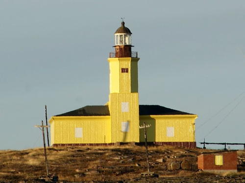
1896. Active; focal plane 47 m (154 ft); two flashes, green and then red, every 9.6 s. 13 m (43 ft) lantern and gallery mounted at one end of a 2-story metal-clad building. The metal siding is bright yellow; lantern painted red. Fog horn (two blasts every 30 s). A photo is at right, Lightphotos.net has a photo by Sergey Shevkoplyas, Dmitry Tarakanov has a 2021 view from the sea, Wikimedia has a foggy distant view, and Bing has a satellite view. The metal siding covers badly weathered masonry seen in an earlier photo. This was not a perfect solution; the Shevkoplyas photo taken in September 2009 shows most of the siding on one side of the building ripped off by severe weather. This light stands at the end of a westward-pointing promontory about 90 km (56 mi) east of Murmansk, marking the entrance to a bay leading to the settlement of Teriberka. Site status unknown. ARLHS ERU-024; Admiralty L6440; RU 2103-0905; NGA 15336.
Ostrov Gavrilovskiy (Ostrov Voron'i Ludki) (2?)
Date unknown. Active; focal plane 29 m (95 ft); white flash every 3 s. 13 m (43 ft) square pyramidal skeletal tower. The front of the lighthouse is covered by a slatted daymark painted white with a black vertical stripe. No photo available but Bing has a satellite view. Lightphotos.net has a historic photo of an earlier lighthouse on this island. Located on an island off the coast about 40 km (25 mi) east of Teriberka. Accessible only by boat. Site status unknown. ARLHS ERU-094; Admiralty L6446; RU 2103-0930; NGA 15344.
[Porchnikha]
Date unknown. Active; focal plane 23 m (75 ft); flash every 3 s, white or red depending on direction. 3 m (10 ft) square red tower. No photo and the small tower is not seen in Google's satellite view. Located on a cape of the mainland sheltering the harbor of the village of Porchnikha. Site status unknown. Admiralty L6471.
Teriberskiy Light
Mys Teriberskiy Light, Teriberka, April 2004
Lightphotos.net photo posted by Dmitry Rsotopshin
Ostrov Bol'shoy Oleniy
Date unknown (station established 1910). Active; focal plane 49 m (161 ft); three white flashes, short-long-short, every 14 s. 24 m (79 ft) round concrete tower with gallery; lantern removed. Tower painted yellow with white trim. The EDM Company restored the lighthouse in 2005, removing the lantern and adding solar power. Evgeny Grigor'jan's photo of the station shows the lighthouse and the original keeper's house, Lightphotos.net has a closeup and a view of the station from the sea, Vyacheslav Vertyanov has a distant view, and Google has a satellite view. Lightphotos.net also has a historic photo of the lighthouse before the restoration. Located near the northwestern end of the island, just off the coast opposite Porcnicha. Site status unknown. ARLHS ERU-084; Admiralty L6472; RU 2103-0980; NGA 15376.
Ostrov Bol'shoy Oleniy Vostochnyy
Date unknown. Active; focal plane 48 m (158 ft); two quick flashes every 6 s, white or red depending on direction. 7 m (23 ft) square pyramidal tower covered with a daymark painted with black and white horizontal bands. No photo available but Google has a satellite view. Located on a smaller island just off the southeastern tip of Bol'shoy Oleniy. Site status unknown. Admiralty L6476; NGA 15380.

Lovozersky District and Ostrovnoy Lighthouses

Kharlovka Area Lighthouses
Guba Zolotaya (Zolotay Bay)
Date unknown. Active; focal plane 65 m (213 ft); white flash every 5 s. 9 m (30 ft) square pyramidal tower covered with a daymark painted black with a white vertical stripe on each face. No photo available but Bing has a satellite view. Located on a steep promontory about 16 km (10 mi) northwest of the Kharlovskiy lighthouse (next entry). Site status unknown. ARLHS ERU-130; Admiralty L6490; NGA 15404.
Kharlovskiy (Ostrov Kharlov, Semiostrovskiy) (2)
Date unknown. Active; focal plane 121 m (397 ft); three white flashes every 13.8 s. 11 m (36 ft) square pyramidal wood tower, painted pale yellow. Keeper's house and other station buildings. The EDM Company restored this lighthouse, removing its lantern, in 2006. Lightphotos.net has a 2005 (pre-restoration) photo and Bing has a satellite view. This light is somewhat undistinguished in appearance but its great height gives it a range of 42 km (26 mi), making it one of the most powerful lights of the Arctic. Lightphotos.net also has a historic photo of the original lighthouse. Located on the highest point of Ostrov Kharlov, which shelters of the harbor of the Kharlovka settlement. Site status unknown. ARLHS ERU-096; Admiralty L6494; RU 2103-1050; NGA 15408.
Vostochnaya Litsa
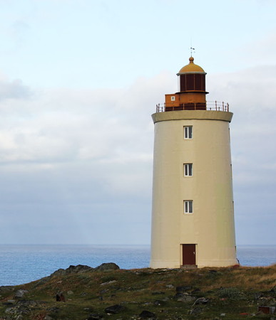
Date unknown (station established 1910). Active; focal plane 50 m (164 ft); two flashes, white, red or green depending on direction, every 12 s. 17 m (56 ft) round cylindrical concrete tower with gallery and a small modern lantern, painted with red and white horizontal bands. Keeper's house and other station buildings. Lightphotos.net has the photo at right and Google has a satellite view of the station. Located on the north side of the entrance to a fjord leading to the settlement of Vostochnaya Litsa. Site status unknown. ARLHS ERU-033; Admiralty L6506; RU 2103-1055; NGA 15416.
Mys Cherniy
Date unknown. Active; focal plane 78 m (256 ft); white flash every 5 s. 17 m (56 ft) round tower with lantern and gallery, painted red with a white horizontal band. No photo available but Google has a good satellite view. Located on a promontory about 10 km (6 mi) east of Drozdovka. Site status unknown. ARLHS ERU-018; Admiralty L6516; RU 2103-1090; NGA 15432.

Vostochnaya Litsa Light, Vostochnaya Litsa
Lightphotos.net photo posted by Dmitry Rsotopshin

Ostrovnoy (Svyatoy Nos Area) Lighthouses
Ostrovnoy is a town (a former Soviet naval base) on the central Barents Sea coast of the Kola Peninsula. The town's population of about 2000 is less than half its size during the late Soviet period. The town is under federal administration, separated from the Lovozersky District. Svyatoy Nos (Svyatoy Point) is a narrow peninsula, about 16 km (10 mi) long, that projects northward into the Barents Sea east of Ostrovnoy and about 65 km (40 mi) west of the entrance to the White Sea. The cape protects Ostrovnoy from easterly gales.

Ostrov Chaichiy
Date unknown. Active; focal plane 50 m (164 ft); flash every 1.5 s, white or green depending on direction. 10 m (33 ft) square pyramidal tower, red with a white diagonal stripe on each side. No photo available but Google has an indistinct satellite view. This light marks the northern entrance to Ostrovnoy harbor. Located at the west end of the island in Svyatoy Bay, about 15 km (9 mi) northwest of Ostrovnoy. Accessible only by boat. Admiralty L6520; RU 2103-1175; NGA 15452.
Ostrov Medvezhiy
Date unknown. Active; focal plane 40 m (131 ft); white flash every 5 s. 10 m (33 ft) octagonal concrete tower on a square base, painted yellow. Abandoned 1-story keeper's house. A photo of the station is available and Google has a satellite view. Located at the west end of an island in Svyatoy Bay, the bay sheltered by Svyatoy Nos. Accessible only by boat. Admiralty L6521; RU 2103-1195; NGA 15444.
Iokan'gskiy Range Front
Date unknown. Active; focal plane 16 m (52 ft); continuous red light visible only on the range line. 18 m (59 ft) square skeletal tower. No photo available but Google has a satellite view. This is an entrance range guiding vessels between isalnds in Svyatoy Bay. Located about 5 km (3 mi) southeast of the town. Site status unknown. Admiralty L6522; NGA 15448.
Iokan'gskiy Range Middle
Date unknown. Active; focal plane 41 m (135 ft); continuous red light visible only on the range line. 18 m (59 ft) square skeletal tower. No photo available but Google has a satellite view. Located 500 m (0.3 mi) south southwest of the front light. Site status unknown. Admiralty L6522.05; NGA 15448.1.
Iokan'gskiy Range Rear
Date unknown. Active; focal plane 41 m (135 ft); continuous red light visible only on the range line. 18 m (59 ft) square skeletal tower. No photo available but Google has a satellite view. Located 500 m (0.3 mi) south southwest of the front light. Site status unknown. Admiralty L6522.1; NGA 15448.2.
Ostrov Zelenyy (Iokan'gskiy Reydovyy) Range Front
Date unknown. Active; focal plane 39 m (128 ft); red flash every 1.5 s visible only on the range line. 19 m (62 ft) square pyramidal skeletal tower carrying a daymark painted white with a red vertical stripe. No photo available but Google has a satellite view. Located on Ostrov Zelenyy, an island on the east side of Svyatoy Bay. Accessible only by boat. Site status unknown. Admiralty L6523; NGA 15457.
Ostrov Zelenyy (Iokan'gskiy Reydovyy) Range Rear (?)
Date unknown. Active; focal plane 58 m (190 ft); red flash every 1.5 s visible only on the range line. 6 m (20 ft) tower carrying a daymark painted white with a red vertical stripe. No photo available and the tower is not seen in Google's satellite view. Located on Ostrov Zelenyy, an island on the east side of Svyatoy Bay. Accessible only by boat. Site status unknown. Admiralty L6523.1; NGA 15457.1.
Svyatoy Nos
1863. Active; focal plane 94 m (308 ft); two white flashes every 15 s. 22 m (72 ft) tapered octagonal wood tower with lantern and gallery. The lighthouse is painted a yellow-orange (peach) color; the lower half of the lantern is painted red and the upper half white. Lightphotos.net has Sergey Gruzdev's photo (also seen at right), and Google has a satellite view. This remarkable lighthouse is the oldest surviving lighthouse in the Russian Arctic. Russia's first steam-powered foghorn was installed here in 1872 and the Fresnel lens installed in 1890 remains in use. Recently restored, the lighthouse was declared a national historic monument in 2002. Located on the west side of Svyatoy Nos, about 3 km (1.8 mi) south southeast of the tip of the peninsula. Site status unknown. ARLHS ERU-124; Admiralty L6534; RU 2103-1205; NGA 15464.
Svyatoy Nos Light
Svyatoy Nos Light, Ostrovnoy, March 2007
ex-Panoramio Creative Commons photo by Sergey Gruzdev
Mys Koroviy Nos
Date unknown. Active; focal plane 87 m (285 ft); white flash every 2.5 s. 19 m (62 ft) square cylindrical skeletal tower. The tower carries a slatted daymark painted white with a red vertical stripe. No photo available and clouds block Bing's satellite view; Google has only a fuzzy satellite view of the area. Located on a promontory near the east side of the base of Svyatoy Nos. Site status unknown. ARLHS ERU-248; Admiralty L6537; RU 2105-3005; NGA 15468.

Kola Peninsula East Coast Lighthouses
These lighthouses guide vessels entering the White Sea from the Barents Sea (the waters south of Svyatoy Nos are considered part of the White Sea). This coast has no permanent settlements. It faces a strait, narrowing in the south to 50 km (30 mi) wide, leading to the main basin of the White Sea. In Russia this strait is called the White Sea Throat (Gorlo Belogo Morja). Because the White Sea is entirely surrounded by Russian territory it is considered an inland waterway.

Mys Bol'shoy Gorodetskiy
1899. Active; focal plane 55 m (180 ft); three white flashes every 13.8 s. 19 m (62 ft) 2-stage cylindrical brick tower, lower half square and upper half octagonal, with lantern and gallery, rising from the front of a 1-story masonry keeper's house. The building has been restored and is covered with yellow siding; lantern painted black. Originally the upper stage of the tower was unpainted red brick and the rest of the building was painted yellow. Fog horn (Morse code "U": two shorts and one long, every 30 s). Lightphotos.net has a closeup photo and a second photo (also seen at right) and Google has a satellite view of the station. Before restoration the former stucco covering of the brick had peeled off almost entirely. This lighthouse marks the point where ships bound for the White Sea begin turning southward into the entrance. Located on a headland on the northeast corner of the Kola Peninsula. Site status unknown. ARLHS ERU-240; Admiralty L6553; RU 2105-3030; NGA 15488.

Mys Bol'shoy Gorodetskiy Light, White Sea Throat, October 2013
Lightphotos.net photo from Polar Post
Mys Ostryye Ludki
Date unknown. Active; focal plane 133 m (436 ft); two white flashes every 15 s. 22 m (72 ft) square pyramidal skeletal tower, covered by a slatted daymark painted white with a red vertical stripe on each face. No photo available but the shadow of the tower is prominent in Google's satellite view. Located high on a bluff about 30 km (19 mi) northwest of the Tersko-Orlovskiy lighthouse. Site status unknown. ARLHS ERU-263; Admiralty L6556; RU 2105-3035; NGA 15492.
Tersko-Orlovskiy
1842. Active; focal plane 88 m (289 ft); two white flashes every 6 s. 20 m (66 ft) round old-style, stucco-clad brick tower with lantern and gallery; the tower probably includes keeper's quarters. Lantern painted red. Fog horn (five blasts every 60 s). Formerly the unpainted gray stucco was chipping off, revealing patches of the red brick. Jim Monchegorsk's August 2010 photo at right shows that the lighthouse was restored that summer. Wikimapia has several older photos, Lightphotos.net has a photo and a 2013 view by D. Lobusov, Huelse has a historic postcard view, and Google has a wintry satellite view of the station. This historic light station is located on a headland north of the easternmost tip of the Kola Peninsula. Site open; tower status unknown. ARLHS ERU-069; Admiralty L6560; RU 2105-3045; NGA 15496.
Ostrov Veshnyak
Date unknown. Active; focal plane 44 m (144 ft); white flash every 5 s. 25 m (82 ft) octagonal wood tower with lantern and gallery, painted with red and white horizontal bands. Wikimapia has a closeup photo, Lightphotos.net has Yuri Matseevskii's closeup photo and another photo, there is a view from the sea (1/3 the way down the page), and Google has a good satellite view. This light marks the extreme eastern end of the Kola Peninsula. Located on an island off Tri Ostrova ("Three Islands"). Accessible only by boat. Site status unknown. ARLHS ERU-072; Admiralty L6564; RU 2105-3050; NGA 15500.
Tersko-Orlovskiy Light
Tersko-Orlovskiy Light, White Sea Throat, August 2010
LiveJournal photo copyright Jim Monchegorsk; permission requested
Ostrova Ponoyskiye Ludki
Date unknown. Active; focal plane 20 m (66 ft); three white flashes every 12 s. 18 m (59 ft) square pyramidal skeletal tower, partially covered by a slatted daymark painted red with a white horizontal band. Lightphotos.net has Alexey Vukolov's photo and Google has a satellite view. Located on a skerry off the mouth of the Ponoy fjord near Korabel'noye. Accessible only by boat. Site status unknown. ARLHS ERU-165; Admiralty L6572; RU 2105-3380; NGA 15512.
Ostrov Danilov
Date unknown. Active; focal plane 17 m (56 ft); white flash every 5 s. 14 m (46 ft) square skeletal tower covered on three sides by a slatted daymark painted with red and white horizonal bands. A photo (halfway down the page) shows the lighthouse restored and the original lantern discarded on the ground. Lightphotos.net has a view from the sea by Peter and Nataliya Bogorodskie but Google has only a very distant satellite view of the island. Located on a small island on the west side of the passage into the White Sea, a short distance offshore and about 35 km (22 mi) northeast of Sosnovka. Site status unknown. ARLHS ERU-161; Admiralty L6576; RU 2105-3390; NGA 15516.
Ostrov Sosnovets North
Date unknown. Active; focal plane 14 m (46 ft); one quick white flash every 1.5 s. 6 m square white pyramidal tower. No photo available and Google has only a distant satellite view of the island. Accessible only by boat. Site status unknown. Admiralty L6582; NGA 15524.
Sosnovetskiy (Ostrov Sosnovets) (5)
Date unknown (station established 1823). Active; focal plane 44 m (144 ft); two white flashes every 7.2 s. 31 m (102 ft) cylindrical iron tower with lantern and gallery. Lighthouse painted with black and white horizontal bands; lantern painted red. Fog horn (eight blasts every 48 s). The EDM Company restored the lighthouse in 2006. The company's "after" photo is at right, a view from the sea is available, and Lightphotos.net has A.P. Oboimov's aerial photo, but Google has only a distant satellite view of the island. Huelse has a historic postcard view of the 1909 lighthouse, a cast iron tower with central cylinder. Located on an island (Ostrov Sonovets) about 4 km (2.5 mi) east of Sosnovka. Accessible only by boat. Site status unknown. ARLHS ERU-066; Admiralty L6580; RU 2105-3395; NGA 15520.
Ostrov Sosnovets South
Date unknown. Active; focal plane 11 m (36 ft); quick-flashing white light. 6 m square white pyramidal tower. No photo available and Google has only a distant satellite view of the island. Accessible only by boat. Site status unknown. Admiralty L6584; NGA 15528.
Ostrov Sosnovets Light
Ostrov Sosnovets Light, Sosnovka, 2006
photo copyright EDM Manufacturing Company, Severomorsk

Information available on lost lighthouses:

Notable faux lighthouses:

Adjoining pages: East: Eastern White Sea | South: Northern White Sea | West: Murmansk Area

Return to the Lighthouse Directory index | Ratings key

Posted December 7, 2005. Checked and revised March 5, 2024. Lighthouses: 39. Site copyright 2024 Russ Rowlett and the University of North Carolina at Chapel Hill.