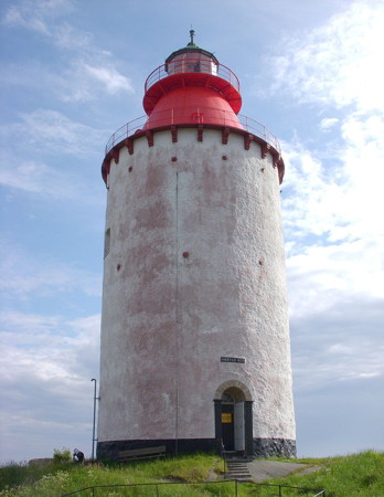
Lighthouses of Sweden: Värmdö to Nynäshamn

The nation of Sweden (Sverige in Swedish) is the largest country of northern Europe, occupying the entire west coast of the Baltic Sea. Along with its lengthy coast Sweden has a distinguished lighthouse history and a good record of preserving its historic lights. The Swedish Lighthouse Society (Svenska Fyrsällskapet) works actively for the preservation of the lighthouses.

Sweden is divided into 21 counties (län) and the counties are subdivided into townships and municipalities (kommuner). This page covers lighthouses of the southeastern part of Stockholms Län (Stockholm County), from Sandhamn due east of Stockholm to Landsort in the south including the municipalities of Värmdö, Haninge, and Nynäshamn. This area is part of the maze of islands and waterways known as the Stockholm Archipelago. The many channels and passages require a large number of lighthouses but nearly all of them are located offshore or on isolated islands; only a few are easily accessible to the public.

Lighthouses of the northern portions of the Stockholm Archipelago are described on the Stockholm Area page.

The Swedish word for a lighthouse is fyr. The front light of a range is the nedrefyr (lower light) and the rear light is the övrefyr (upper light). Ö is an island, holme is an islet, skär is a skerry (a tiny island or rocky reef), grund is a shoal or shallow, sund is a strait (often between an island and the mainland), vik is a bay, hav is a sea, udde is a headland, flod is a river, and hamn is a port or harbor.

Aids to navigation in Sweden are maintained by the Swedish Maritime Administration (Sjöfartsverket).

ARLHS numbers are from the ARLHS World List of Lights. SV numbers are from the Sjöfarsverket light list (Fyrlista) as reported by the Swedish Lighthouse Society. Admiralty numbers are from volume C of the Admiralty List of Lights & Fog Signals. U.S. NGA List numbers are from Publication 116.

General Sources
Swedish Lighthouse Society (Svenska Fyrsällskapet, SFA)
The Society is active in promoting the preservation of Swedish lighthouses.
Svenskt Fyrväsende
From the SFA web site, data and photos for many of the lighthouses.
Online Lists of Lights - Sweden
Photos by various photographers posted by Alexander Trabas.
Leuchttürme und Leuchtfeuer in Schweden - Svenska Fyrar
A large collection of photos and data posted by Erich Hartmann; text in German.
Lighthouses in Sweden
Photos by various photographers available from Wikimedia.
Lista över fyrar i Stockholms skärgård
Swedish Wikipedia's list of lighthouses of the Stockholm Archipelago; photos are available for many of them.
Lighthouses in Sweden
Aerial photos posted by Marinas.com.
Fyr Vi Har Passeret (Lighthouses We've Passed)
Photos of Baltic lighthouses taken by two Danish sailors, Jette and Ole.
Leuchttürme in Schweden
Photos posted by Bernd Claußen.
Schwedische Leuchttürme auf historischen Postkarten
Historic postcard views posted by Klaus Huelse.
Navionics Charts
Navigation chart for Sweden.


Svenska Högarna Light, Värmdö, June 2014
Wikimedia Creative Commons photo by Arild Vågen

Värmdö Lighthouses

The Värmdö municipality includes the easternmost islands of the Stockholm Archipelago, facing the open Baltic Sea due east of the capital city. The municipal population is about 45,000.

Stockholm Southern Approach Lighthouses
Lindalen Nedre (2)
1942 (station established 1883). Active; focal plane 4 m (13 ft); white, red or green light, depending on direction, 2 s on, 2 s off. 4 m (13 ft) round cylindrical concrete tower with lantern and gallery, painted white. Wikimedia has Johan Fredriksson's closeup, Trabas has a photo, and Google has a satellite view. This is a westbound range guiding vessels approaching Stockholm. The rear light is on a mast. Located in the channel near Vårholma. Accessible only by boat. Site open, tower closed. SV-2980; Admiralty C6518; NGA 9448.
Valöarna (2)
1958 (station established 1912). Active; focal plane 4 m (13 ft); four flashes every 12 s, white, red or green depending on direction. 4 m (13 ft) octagonal lantern and gallery mounted on a round concrete pier. Lantern painted white, pier black. Trabas has a photo, Wikimedia has Johan Fredriksson's photo, Oskar Henriksson has a photo, and Google has a satellite view. Located on a skerry about 800 m (1/2 mi) northeast of Vårholma. Accessible only by boat. Site open, tower closed. SV-2965; Admiralty C6454; NGA 9716.
Kalvö
1942 (station established 1912). Active; focal plane 16 m (52 ft); two flashes every 6 s, white, red or green depending on direction. 10 m (33 ft) round cylindrical concrete tower with lantern and gallery. The tower is unpainted white concrete; lantern painted white with a green horizontal band. Jim Grant's photo is at right, Trabas has a good photo, Wikimedia has Johan Fredriksson's photo, another photo is available, and Google has a satellite view. Located on the north side of the channel on the southern tip of Kalvö, about 800 m (1/2 mi) east of Boda. Site status unknown. ARLHS SWE-209; SV-2940; Admiralty C6508; NGA 9420.
Magarna
1939. Active; focal plane 4 m (13 ft); three flashes every 9 s, white, red or green depending on direction. 4 m (13 ft) octagonal lantern mounted on a round concrete base. Lantern painted white with a black horizontal band. Trabas has a photo, Wikimedia has Johan Fredriksson's photo, and Google has a satellite view. Located on a skerry marking a bend in the channel near Sollenkroka. Accessible only by boat. Site open, tower closed. SV-2928; Admiralty C6504; NGA 9408.
Klövholmen (2?)
Date unknown (station established 1885). Active; focal plane 7 m (23 ft); two flashes every 6 s, white, red or green depending on direction. The light is mounted on the front wall of a 1-1/2 story wood keeper's cottage, painted white. Wikimedia has Johan Fredriksson's 2011 photo, Trabas has a photo, and Google has a satellite view. The station also includes two day range towers carrying slatted daymarks colored orange with a white vertical stripe. Located on the south side of the island of Klövholmen. Accessible only by boat. Site open, tower closed. SV-2920; Admiralty C6498; NGA 9396.
Kalvö Fyr
Kalvö Light, Värmdö, August 2008
Flickr Creative Commons photo by Jim Grant
* Gustavsberg (?)
Date unknown. Inactive. 4 m (13 ft) octagonal lantern, painted white and mounted on a round pedestal. Google has a street view and a satellite view. This is obviously a relocated lantern and we do not know its origin. Located on the Skargårdsvägen at the intersection of the Bergmossevägen in Gustavsberg. Site open, tower closed.

Möja Area Lighthouses
Stenkobbsgrund
1939. Active; focal plane 12.5 m (41 ft); two flashes every 6 s, white, red or green depending on direction. 13 m (43 ft) round cylindrical concrete tower with lantern and gallery, painted white with a green horizontal band. A 2008 photo is available, Fredrik Wikfeldt has a 2012 photo, and Google has a satellite view. Located on a skerry about 500 m (0.4 mi) north of Lökaön island and 1.5 km (1 mi) east of the eastern tip of Möja island. Accessible only by boat. Site open, tower closed. ARLHS SWE-368; SV-2765; Admiralty C6404; NGA 9344.
Pålkobb
1939. Active; focal plane 10 m (33 ft); four flashes every 10 s, white, red or green depending on direction. 10 m (33 ft) round cylindrical concrete tower with lantern and gallery, painted white with a green horizontal band. Wikimedia has Dick Rochester's photo (also seen at right), Kristofer Lindberg also has a photo, and Google has a satellite view. Located on a small island about 2.5 km (1.5 mi) east of Möja. Accessible only by boat. Site open, tower closed. ARLHS SWE-311; SV-2769; Admiralty C6406; NGA 9336.

Svenska Högarna Area Lighthouses
Svenska Björn
1968 (lightship station established 1868). Active; focal plane 32 m (105 ft); one long (2 s) white flash every 8 s. 32 m (105 ft) round cylindrical concrete tower with two galleries and a helipad on top. Lighthouse painted with orange and black horizontal bands. An aerial photo is available but the lighthouse is not shown in Google's satellite view. The lighthouse replaced a lightship station that was served for many years by Fyrskepp 5, a ship now moored at Västerås on Lake Mälären. Located on a shoal in the middle of the Baltic Sea about 27 km (17 mi) east of Svenska Högarna and 52 km (33 mi) east of Möja. Accessible only by boat. Site open, tower closed. ARLHS SWE-065; SV-2796; Admiralty C6459; NGA 9972.
Svenska Högarna
1874 (Nils Gustaf von Heidenstam). Active; focal plane 31 m (102 ft); one long (2 s) white flash every 15 s. 18 m (59 ft) round cast iron skeletal tower with lantern, gallery, and central cylinder. Lighthouse painted red; lantern dome is grayish metallic. A 4th order Fresnel lens has replaced the original 2nd order lens. Arild Vågen's photo is at the top of this page, SFA has a page for the lighthouse, Wikimedia has a 2007 photo, Charlie Börjeson has a 2021 photo, Nelson Harris has a view of the light station, August Rabenius has a 2016 street view, and Google has a satellite view. This historic lighthouse, one of ten surviving lighthouses by von Heidenstam, is owned by the Skärgårdsstiftelsen (Archipelago Foundation). The foundation provides resident caretakers for the station. Located on an island far out in the Baltic, about 25 km (15 mi) east of Möja. Accessible only by boat. Site open, tower closed. Owner/site manager: Skärgårdsstiftelsen. . ARLHS SWE-066; SV-2800; Admiralty C6460; NGA 9968.
Pålkobbs Fyr
Pålkobb Light, Möja, May 2010
Wikimedia Creative Commons photo by Dick Rochester

Sandhamn Area Lighthouses
Located about 45 km (28 mi) east of Stockholm, the village of Sandhamn ("Sand Harbor") is at the eastern end of the Stockholm Archipelago and the beginning of an approach to the city for vessels arriving from the south.

Yxhammarskobben (Yxhammarsklubben) (2)
1980 (station established 1882). Active; focal plane 8 m (26 ft); three flashes every 9 s, white, red or green depending on direction. 8 m (26 ft) round cylindrical concrete tower with lantern and gallery, painted white with a red horizontal band. Trabas has a closeup, Claußen has a photo (third photo on the page), and Google has a satellite view. Located on a skerry off the northwestern end of Skarprunmarö, about 7 km (4.5 mi) west of Sandhamn. Accessible only by boat. Site open, tower closed. ARLHS SWE-061; SV-2915; Admiralty C6495; NGA 9376.
Skötkobben (Nedre) (2)
1967 (station established 1892). Active; focal plane 8 m (26 ft); quick-flashing light, white, red or green depending on direction. 8 m (26 ft) round cylindrical tower with lantern and gallery, painted white with one red horizontal band. Trabas has a photo, Claußen has a photo (last photo on the page), and Google has a satellite view. NGA misspells the name as Skotkubben. Located on a small island about 300 m (0.2 mi) off the northwest coast of Sandö. Accessible only by boat. Site open, tower closed. ARLHS SWE-349; SV-2891; Admiralty C6484; NGA 9120.
* Sandhamn (Övre)
1870. Active; focal plane 10 m (33 ft); white, red or green light, depending on direction, 27.5 s on, 2.5 s off. 11 m (36 ft) square cylindrical wood tower rising from the center of a 1-1/2 story wood pilot house. Henrik Larsson has a photo, Trabas has a great photo, Claußen has two photos (halfway down the page), Huelse has a historic postcard view, and Google has a satellite view. This light was for many years the rear light of a range, but it has been converted to a general purpose directional light. Located on the waterfront of Sandhamn, a popular boating town on the north side of the island of Sandö. Site open, tower closed. Site manager: unknown. ARLHS SWE-056; SV-2874; Admiralty C6472.1; NGA 9084.
* Korsö (2)
1757. Inactive since 1882. 23 m (75 ft) round old-style stone tower with an octagonal stone "lantern" room and gallery. The tower is unpainted. Arild Vågen's photo is at right, SFA has a page for the lighthouse, Lightphotos.net has Johan Fredriksson's photo, Nicolas Martinez has a 2020 photo, Huelse has a historic postcard view, and Google has a satellite view. Lighted beacons are said to have been displayed at this site as early as 1746. When the lighthouse was deactivated its lantern and lens were transferred to Huvudskär. The lantern room was replaced by a watchroom when the military took control of the tower in 1937. This historic lighthouse celebrated its 250th anniversary in 2007. Note: there is also a well-known Korsö ("Cross Island") lighthouse not far away in the Åland Islands of Finland. Located on the south side of the island of Korsö, about 2.5 km (1.5 mi) east of Sandhamn. Site open, tower closed. Site manager: unknown. ARLHS SWE-216; ex-SV-2874.01.
Sandhamns Stångskär (2)
1960 (station established 1933). Active; focal plane 10 m (33 ft); white, red or green light, depending on direction, 2 s on, 2 s off. 7 m (23 ft) octagonal cylindrical concrete tower with lantern and gallery. Entire lighthouse is white. Wikimedia has Bengt Nyman's photo, Trabas has a photo, Claußen has a photo (2/3 the way down the page), and Google has a satellite view. Located on a skerry 1.6 km (1 mi) east of the eastern tip of Korsö. Accessible only by boat. Site open, tower closed. ARLHS SWE-335; SV-2864; Admiralty C6468; NGA 9068.

Korsö Light, Sandhamn, February 2013
Wikimedia Creative Commons photo by Arild Vågen
Grönskär
1770. Reactivated (inactive 1961-2000); focal plane 38 m (125 ft); green light, 2 s on, 8 s off. 26 m (85 ft) octagonal rubblestone tower with lantern and gallery. The tower is pyramidal granite at the base and cylindrical sandstone above; the lantern is placed off center at the top. The tower is unpainted stone, gray granite at the base and buff-colored sandstone above; lantern painted white. A keeper's house, barn, and other light station buildings are preserved. The Skärgårdsstiftelsen posted the photo at right, Wikimedia has Bengt Nyman's photo as well as a historic photo, SFA has a page for the lighthouse, Trabas has a photo, Claußen has photos, Huelse has a historic snapshot photo, and Google has a good satellite view. This historic lighthouse was deactivated in 1961 when the Revengegrundet light was built farther out in the Baltic. In recent years a weak (mostly decorative) green light has been displayed. Located on a small island about 7 km (4.5 mi) east of Sandhamn. Accessible only by boat. Site open, tower closed. Site manager: unknown. . ARLHS SWE-157; SV-2866; Admiralty C6468.5 NGA 9070.
Svängen (Sandhamnssundet)
1973. Active; focal plane 14 m (46 ft); quick-flashing light, white, red or green depending on direction. 15 m (49 ft) round cylindrical concrete tower with lantern and gallery. Lighthouse painted with red and black horizontal bands. Trabas has a photo, Lennart Staflin has a photo, Claußen has two photos (3/4 the way down the page), and Bing has a satellite view. Note: not to be confused with the (better known) Svangen Fyr in the Skagerrak in northern Bohuslän. Located on a shoal about 5 km (3 mi) east southeast of Sandhamn. Accessible only by boat. Site open, tower closed. ARLHS SWE-385; SV-2868; Admiralty C6471.6; NGA 9064.
Horssten
1952. Active; focal plane 14 m (46 ft); four flashes every 12 s, white, red or green depending on direction. 4 m (13 ft) 1-story building; the light is shown through a slit-like window. Lighthouse painted with vertical red and white stripes. A photo (halfway down the page) is available and Google has a satellite view. Located on an island about 12 km (7.5 mi) east of Sandhamn. Accessible only by boat. Site open, tower closed. SV-2825; Admiralty C6463.5; NGA 9076.
Revengegrundet
1961. Active; focal plane 20 m (66 ft); two very long (3 s) flashes every 18 s, white, red or green depending on direction. 30 m (98 ft) round cylindrical concrete tower with lantern and two galleries. Lighthouse painted red with a black band below the lower gallery. Trabas has a closeup photo, Marinas.com has good aerial photos, and Bing has an indistinct satellite view. Located on a shoal about 5 km (3 mi) south southeast of Sandhamn. Accessible only by boat. Site open, tower closed. ARLHS SWE-321; SV-2863; Admiralty C6470; NGA 9060.

Grönskär Light, Sandhamn, August 2019
Skärgårdsstiftelsen Instagram photo

Namdö Area (Namdöfjärden) Lighthouses
Franska Stenarna
Date unknown (station established 1916). Active; focal plane 5 m (17 ft); two flashes every 6 s, white, red or green depending on direction. 5 m (17 ft) octagonal lantern, mounted on a round concrete pier. Lantern painted green with a white roof; base painted white. Wikimedia has Johan Fredriksson's photo, Trabas has a photo and Google has a satellite view. Located on a skerry about 1.5 km (1 mi) southwest of Hölö. Accessible only by boat. Site open, tower closed. SV-3492; Admiralty C6666; NGA 9300.
Kofotsgrund
1953. Active; focal plane 7 m (23 ft); very quick-flashing light, white, red or green depending on direction, interrupted once every 9 s. 8 m (26 ft) round cylindrical concrete tower with lantern and gallery. Tower painted green, lantern white. Wikimedia has Johan Fredriksson's photo and Google has a satellite view. Located on a shoal about 6 km (4.5 mi) east of Klacknäset and km (2.5 mi) northwest of Namdö. SV-3484; Admiralty C6662; NGA 9292.
Grönö (2)
1934 (station established 1895). Active; focal plane 7 m (23 ft); white, red or green light, depending on direction, 2 s on, 2 s off. 8 m (26 ft) round cylindrical concrete tower with lantern and gallery. Lighthouse painted white, lantern red with a white roof. Johan Fredriksson's photo is at right, Kent Lindberg has a photo (misidentified as Kofotsgrund), another photo (halfway down the page) is available, and Google has a satellite view. Located on a small island about 2 km (1.2 mi) southeast of Klacknäset and 4 km (2.5 mi) west of Namdö. SV-3480; Admiralty C6660; NGA 9288.
Fjärdhällan (2)
Date unknown (station established 1911). Active; focal plane 8 m (26 ft); flash every 3 s, white, red or green depending on direction. 7 m (23 ft) round cylindrical concrete tower with lantern and gallery. Tower painted black, lantern white. Wikimedia has Johan Fredriksson's photo and Google has a satellite view. The original light was an octagonal lantern. Located on a skerry about 5 km (3 mi) northeast of Ornö and 3 km (2 mi) southwest of Namdö. Accessible only by boat. Site open, tower closed. SV-3455; Admiralty C6658; NGA 9284.
Grönös Fyr
Grönö Light, August 2010
Wikimedia Creative Commons photo by Johan Fredriksson

Haninge Lighthouses

The Haninge municpality includes islands of the Stockholm Archipelago southeast of the capital city. The municipal population is about 96,000.

Huvudskär and Central Baltic Sea Lighthouses
These lighthouses warn ships in the Baltic away from the Stockholm Archipelago.

Almagrundet
1964 (lightship station established 1897). Active; focal plane 28 m (92 ft); four flashes every 12 s, white or red depending on direction. 30 m (98 ft) round cylindrical concrete tower with two galleries and a helipad on top. Lighthouse painted black with a broad red band near the top. SFA has a page for the lighthouse, Trabas has a very distant view, and Marinas.com has aerial photos but the lighthouse is not shown in Google's satellite view. This lighthouse replaced a lightship station discussed in Wikipedia's article. From 1897 to 1912 the station was served by Fyrskepp 2B, a lightship now moored at Gävle in Southern Bothnia. Located on a shoal far out in the Baltic, about 25 km (15 mi) east of Huvudskär and 16 km (10 mi) southeast of Sandhamn. Accessible only by boat. Site open, tower closed. . ARLHS SWE-002; SV-2855; Admiralty C6465; NGA 9056.
** Huvudskär (2)
1931 (station established 1882). Active; focal plane 26 m (85 ft); white light, 4 s on, 4 s off, 1 s on, 16 s off. 16 m (52 ft) round cylindrical concrete tower with lantern and gallery. Lighthouse painted white with one black horizontal band. Arild Vågen's photo appears at right, SFA has a page for the lighthouse, Emmi West has a good photo, CarlVictor Hagersten has a street view, and Google has a satellite view. This lighthouse replaced a wood keeper's house with a lantern on the roof. Huvudskär is the largest of a group of islands that together form the southeasternmost extension of the Stockholm Archipelago. The island has cabins and campgrounds and is popular as a day trip destination, accessible by passenger ferry from Stockholm. Located at the highest point of the island. Site open, and apparently the tower can be climbed. . ARLHS SWE-202; SV-3250; Admiralty C6576; NGA 9040.

Dalarö Area Lighthouses
Hummelkläpp
1930. Active; focal plane 6 m (20 ft); white, red or green light depending on direction, 2 s on, 2 s off. 7 m (23 ft) round cylindrical concrete tower with lantern and gallery. Lighthouse painted white with one red horizontal band. Wikimedia has Johan Fredriksson's closeup photo, Trabas has a photo, and Google has a distant satellite view. NGA describes the lighthouse as being all red. Located on the south side of a small island about 800 m (1/2 mi) northeast of Dalarö. Accessible only by boat. Site status unknown. SV-3450; Admiralty C6648; NGA 9260.

Huvudskär Light, Haninge, August 2015
Wikimedia Creative Commons photo by Arild Vågen
Genböte
Date unknown (station established 1930). Active; focal plane 24 m (78 ft); white, red or green light, depending on direction, 1.5 s on, 1.5 s off. 4 m (13 ft) lantern, white with a red roof, mounted on a concrete pad. Trabas has a photo, Wikimedia has Johan Fredriksson's photo, and Google has a satellite view. Located on a bluff opposite the Dalarö light. Access to the light seems to be by a staircase cut into the rock. Site open, tower closed. SV-3422; Admiralty C6644; NGA 9256.
Dalarö
Date unknown (station established 1899). Active; focal plane 4 m (13 ft); three flashes every 9 s, white, red or green depending on direction. 5 m (17 ft) round stone tower with lantern and gallery, mounted on a concrete pier. The tower is unpainted; lantern painted white with a red horizontal band. A drone view is available, Trabas has a photo, Wikimedia has Johan Fredriksson's photo, and Google has a street view and a satellite view. Located on a shoal at the entrance to the harbor of Dalarö, a resort town on the mainland about 20 km (13 mi) southeast of Stockholm. Accessible only by boat, but there should be good views from shore. Site open, tower closed. SV-3445; Admiralty C6646; NGA 9268.
* Dalarö Skans (Övre)
Date unknown. Inactive. 5 m (17 ft) round cylindrical concrete tower with lantern and gallery, painted white. Henrik Larsson's photo is at right, Bengt Nyman has a photo, and Google has a satellite view. Wikimedia has a 1950 photo. The lighthouse stands next to a 17th century stone fortification known as Dalarö Skans; the buildings have been renovated as a restaurant. The light was formerly the rear light of a range, probably with the Dalarö light (see above) as the front light. Located on a small island off the Dalarö waterfront. Site open; obviously visitors can climb on the gallery. Site manager: Dalarö Skans. ex-SV-3410.

Dalarö Skans Light, Dalarö, June 2005
Flickr Creative Commons photo by Henrik Ismarker

Nynäshamn Lighthouses

The Nynäshamn municipality includes the southern portion of the Södertörn peninsula, which projects southward from Stockholm into the Baltic Sea. The municipal population is about 30,000.

Nynäshamn Area Lighthouses
Långgarn
1954. Active; focal plane 6 m (20 ft); three flashes every 9 s, white, red or green depending on direction. 7 m (23 ft) round cylindrical concrete tower with lantern and gallery. Lighthouse painted white with an orange band under the gallery. Trabas has a photo and Google has a satellite view. Located on a reef off the eastern tip of a rocky island about 6 km (3.5 mi) west of Ornö. Accessible only by boat. Site open, tower closed. SV-3400; Admiralty C6623; NGA 9204.
Mysingeholm
1954. Active; focal plane 8 m (26 ft); white, red or green light, depending on direction, 2 s on, 2 s off. 6.5 m (21 ft) round cylindrical concrete tower with lantern and gallery. NGA and the SFA page say the lighthouse is painted white with a red roof but Franz Airiman's photo and a photo on Lightphotos.net show it to be white with a narrow green horizontal band. Google has a satellite view. Located on the western point of an island about 3 km (2 mi) southeast of Hyttan. Accessible only by boat. Site open, tower closed. SV-3375; Admiralty C6619; NGA 9196.
Älvsnabben (Svartudden)
1966. Active; focal plane 7 m (23 ft); quick-flashing light, white, red or green depending on direction. 5 m (17 ft) round cylindrical concrete tower with lantern and gallery. Lighthouse painted white with a broad red horizontal band around the lantern. Wikimedia has Björn Persson's closeup photo and Google has a satellite view. Located on the southern tip of Kapellön, an island off the southeast side of the larger island of Älvsnabben and about 2 km (1.2 mi) southeast of Muskö. Accessible only by boat. Site open, tower closed. SV-3373; Admiralty C6618.4; NGA 9192.
Örngrund
1978. Active; focal plane 10 m (33 ft); quick-flashing light, white, red or green depending on direction. 11 m (36 ft) round cylindrical concrete tower with lantern and two galleries. Lighthouse painted with red and black horizontal bands. Johan Fredriksson's photo is at right, Hartmann has a page for the lighthouse, Trabas has Andreas Köhler's closeup photo, and Bing has an indistinct satellite view. Located on a shoal about 5 km (3 mi) east of Nynäshamn. Accessible only by boat. Site open, tower closed. ARLHS SWE-303; SV-3358; Admiralty C6598; NGA 9184.
* Brunnviksholmen (Brunviksholmen)
1920. Active; focal plane 8 m (26 ft); two flashes every 6 s, white, red or green depending on direction. 6 m (20 ft) round cylindrical concrete tower with lantern and gallery. Lighthouse painted white, formerly with an orange band under the gallery. Seth Chisamore has a photo, Trabas has Helmut Seger's photo, Wikimedia has Johan Fredriksson's photo, and Google has a satellite view. Located on the north side of the entrance to Nynäshamn harbor. Site open, tower closed. ARLHS SWE-109; SV-3360; Admiralty C6614; NGA 9180.
Skrapan (2)
1954 (station established 1932). Active; focal plane 12.5 m (41 ft); three flashes every 9 s, white, red or green depending on direction. 11 m (36 ft) round cylindrical concrete tower with lantern and gallery. Lighthouse painted with black and white horizontal bands. Hartmann has a page for the lighthouse, Wikimedia has Johan Fredriksson's photo and Google has a satellite view. Located on a small island about 6 km (3.5 mi) east of Öja and 8 km (5 mi) south of Nynäshamn. Accessible only by boat. Site open, tower closed. ARLHS SWE-350; SV-3305; Admiralty C6588; NGA 9140.

Örngrund Light, Nynäshamn, August 2014
SFA Creative Commons photo by Johan Fredriksson
* Måsknuv (2)
1937 (station established 1868). Active; focal plane 13 m (43 ft); white, red or green light, depending on direction, 1 s on, 1 s off, 3 s on, 3 s off. 10 m (33 ft) round cylindrical concrete tower with lantern and gallery. Lighthouse painted white. Nearby is a square wood fog bell tower built in 1900. A 2009 view that also shows the bell tower is available, Trabas has Helmut Seger's photo, Marinas.com has aerial photos, and Google has a satellite view. Måstnuv is a small island just west of the larger island of Mälsten. Located at the western tip of the island, about 5 km (3 mi) southeast of Nynäshamn. Accessible only by boat. Site open, tower closed. ARLHS SWE-278; SV-3340; Admiralty C6596; NGA 9152.

Landsort Area Lighthouses
**** Landsort (2)
1687 (upper section added in 1870; station established 1651). Active; focal plane 44 m (144 ft); five flashes every 60 s (a single flash followed 22 s later by four flashes); also a continuous passing light, white, red or green depending on direction, is shown at a focal plane of 27 m (89 ft). 25 m (82 ft) round two-stage tower, lower stage stone cylindrical, upper stage cast iron conical, with lantern and gallery. Stone tower painted white, cast iron painted red; lantern dome is greenish metallic. A 3rd order Fresnel lens is in use; presumably it replaced a 2nd order lens that was transferred to the Storjungfrun lighthouse in Southern Bothnia in 1938. Holger Ellgaard's photo is at right, SFA has a page for the lighthouse, Hartmann also has a page, Dick Rochester has a photo, a 2023 photo and an April 2007 photo are available, Trabas has Erich Hartmann's distant view, a web camera provides a current view, Huelse has a historic postcard view, and Google has a satellite view. This is Sweden's oldest light station; lights are said to have displayed here as early as the 13th century. Landsort is the southern tip of Öja, a narrow island about 2.2 km (1.4 mi) long aligned north to south so that it commands the approaches to Nynäshamn and Stockholm. Open fires were displayed until the first lantern was installed in 1840. In 1870 the conical extension and a modern lantern and Fresnel lens were added. Overnight accommmodations are available in the former pilot station for Stockholm located nearby. The island is accessible by passenger ferry from Nynäshamn. Located at the southern tip of Öja. Site open, tower open daily during the summer season. Site manager: Landsort Maritime and Environmental Center. . ARLHS SWE-039; SV-3275; Admiralty C6584; NGA 9012.
Landsorts Bredgrund
1973. Active; focal plane 19 m (62 ft); white, red or green light, depending on direction, 2 s on, 2 s off. 20 m (66 ft) round cylindrical concrete tower with lantern and two galleries, mounted on a round concrete pier. Lighthouse painted red. Wikimedia has Johan Fredriksson's photo, another photo is available, and Google has a satellite view. Located on a shoal about 1.2 km (3/4 mi) southeast of the Landsort lighthouse. Accessible only by boat, but there is a good view from the Landsort lighthouse. Site open, tower closed. ARLHS SWE-231; SV-3285; Admiralty C6583.6; NGA 9008.
* [Rökogrundet lantern]
Date unknown. 3 m (10 ft) octagonal lantern from the Rökogrundet lighthouse (see below). Lantern painted white. Claußen has photos (last two photos on the page) and Google has a satellite view. Located on the Öja waterfront. Site open.
Landsorts Fyr
Landsort Light, Nynäshamn, 2011
Wikimedia Creative Commons photo by Holger Ellgaard

Torö Area Lighthouses
Tilljandersknallt (Tiljanders Knalt)
1979. Active; focal plane 14 m (46 ft); two long (2 s) flashes every 12 s, white, red or green depending on direction. 14 m (46 ft) round cylindrical concrete tower with lantern and gallery. Lighthouse painted black with one white horizontal band; lantern roof painted green. Claußen has a photo (third photo on the page) and Google has a satellite view. Located on a shoal about 3 km (2 mi) south of Torö and 2 km (1.25 mi) west of Öja. Accessible only by boat. Site open, tower closed. ARLHS SWE-391; SV-3510; Admiralty C6585; NGA 9016.
Västra Röko
1940. Active; focal plane 13 m (43 ft); quick-flashing light, white, red or green depending on direction. 8.5 m (28 ft) round cylindrical concrete tower with lantern and gallery. Lighthouse painted white with a black band around the base. Wikimedia has a photo and Google has a satellite view. Located on a skerry about 400 m (1/4 mi) northeast of the Rökogrundet lighthouse. Accessible only by boat. Site open, tower closed. SV-3520; Admiralty C6675.6; NGA 8888.
Rökogrundet
1940. Active; focal plane 10 m (33 ft); white, red or green light, depending on direction, occulting twice every 12 s. 11 m (36 ft) round cylindrical concrete tower with lantern and gallery. Tower painted black with a white horizontal band; lantern painted black. Wikimedia has a photo and Google has a satellite view. Located about 1200 m (3/4 mi) southwest of the southwestern tip of Torö and 4 km (2.5 mi) east of the southeastern tip of Askö. Accessible only by boat. Site open, tower closed. SV-3522; Admiralty C6675.4; NGA 8892.
Grankubben (2)
1929 (station established 1900). Active; focal plane 13 m (43 ft); four flashes every 12 s, white, red or green depending on direction. 4 m (13 ft) round white lantern. Wikimedia has a photo and Google has a satellite view. Located on a small island about 2.5 km (1.5 mi) east of the easternmost point of Askö. Accessible only by boat. Site open, tower closed. SV-3515; Admiralty C6675; NGA 8896.
Vattklubben
1928. Active; focal plane 10 m (33 ft); white, red or green light, depending on direction, 3 s on, 3 s off. 6 m (20 ft) 11 m (36 ft) round cylindrical concrete tower with lantern and gallery, painted white with a narrow green horizontal band around the lantern. A photo is at right and Google has a satellite view. Located on Stora Vattklubben, a small island about 2 km (1.2 mi) northeast of the eastern tip of Askö. Accessible only by boat. Site open, tower closed. SV-3534; Admiralty C6676.3; NGA 8904.

Vattklubben Light, Nynäshamn, undated
Wikimedia Creative Commons photo by Uabjanh
Fifång (Fifong)
1928. Active; focal plane 7 m (23 ft); three flashes every 9 s, white, red or green depending on direction. 5 m (17 ft) octagonal lantern, mounted on an octagonal concrete base. Lantern painted white with a narrow red horizontal band. Wikimedia has a photo and Google has a satellite view. Lars Johnson has a 1977 photo; at that time the lantern was all white. (It is possible the lantern has been replaced in recent years.) Located on a skerry about 4 km (2.5 mi) northeast of the eastern tip of Askö. Accessible only by boat. Site open, tower closed. SV-3580; Admiralty C6676.8; NGA 8952.
Sankhällan
1958. Active; focal plane 6.5 m (21 ft); quick-flashing light, white, red or green depending on direction. 6.5 m (21 ft) round cylindrical concrete tower with lantern and gallery, painted white; lantern painted red. Wikimedia has the photo seen at right and Google has a satellite view. Located about 1.25 km (3/4 mi) north of Fifång. Accessible only by boat. Site open, tower closed. SV-3586; Admiralty C6677; NGA 8960.
Skvallran
1945. Active; focal plane 10.5 m (35 ft); three flashes every 9 s, white, red or green depending on direction. 12 m (39 ft) round cylindrical concrete tower with lantern and gallery. Tower painted white, lantern red. Google has a satellite view. Located about 600 m (3/8 mi) northeast of the Asenskallen lighthouse, off the southeastern tip of Askö. Accessible only by boat. Site open, tower closed. ARLHS SWE-351; SV-4325; Admiralty C6730; NGA 8864.
Asenskallen
1940. Active; focal plane 12 m (39 ft); flash every 3 s, white, red or green depending on direction. 9 m (30 ft) round cylindrical concrete tower with lantern and gallery. Tower painted white, lantern green with a white roof. Trabas has a very distant view and Google has a satellite view. Located on the northwestern end of a small island off the southeastern tip of Askö. Probably accessible only by boat. Site open, tower closed. ARLHS SWE-086; SV-4328; Admiralty C6732; NGA 8860.

Sankhällan Light, Nynäshamn, April 2008
Wikimedia Creative Commons photo by Uabjanh

Information available on lost lighthouses:

Notable faux lighthouses:

Adjoining pages: North: Stockholm Area | South: Norrköping Area

Return to the Lighthouse Directory index | Ratings key

Posted July 16, 2007. Checked and revised December 13, 2023. Lighthouses: 47. Site copyright 2023 Russ Rowlett and the University of North Carolina at Chapel Hill.