Lighthouses of Japan: Kyōto and Fukui

The nation of Japan, known in Japanese as Nihon or Nippon (日本), occupies an archipelago off the east coast of Asia. The four main islands are Hokkaidō in the north, Honshū (the largest) in the center, Shikoku in the south, and Kyūshū in the southwest. The country includes thousands of other islands of all sizes; among them the Ryūkyū (Nansei) Islands are a long chain extending to the southwest and including the large island of Okinawa, and the Nanpō Islands are another long chain extending south into the Pacific Ocean. Much of Japan is mountainous but the coastal regions are densely populated and urbanized; the country's population is about 126 million.

Japan is divided into 47 prefectures. This page lists lighthouses of two of the prefectures, Kyōto and Fukui. These prefectures have coasts that surround Wasaka Bay, a bight of the Sea of Japan on the southwestern coast of Honshū. This is a rugged and beautiful coast, with many small ports but only a few big ones. Maizuru in Kyōto Prefecture and Tsuruga in Fukui Prefecture are the most important.

In Japanese the word for a lighthouse is tōdai or toudai (灯台). The words saki and misaki are for capes and headlands, hana ("nose") is a promontory, hantō is a peninsula, shima (also spelled sima or jima) is an island, bae is a reef, iwa or shi is a rocky reef, amase or se is a shoal, wan is a bay, nada is a sound or basin, kaikyō is a strait, kawa is a river, and or minato is a harbor.

Lighthouses in Japan are operated and maintained by the Japanese Coast Guard's Maritime Safety Agency. In general there is at least one Coast Guard Section Office in each prefecture, often two or more. Kyōto prefecture has one office at Maizuru and Fukui has one office at Tsuruga.

A note on the Sea of Japan/East Sea controversy: The Directory takes no side in any international dispute; it makes use of the terminology, names, and spellings as they currently exist in each area covered. The sea between Japan and Korea is called the Sea of Japan on the pages for Japan and the East Sea on the pages for Korea.

ARLHS numbers are from the ARLHS World List of Lights. JCG numbers are the Japanese Coast Guard's light list numbers. Admiralty numbers are from volume M of the Admiralty List of Lights & Fog Signals. U.S. NGA List numbers are from Publication

General Sources
Lighthouses in Japan - Kyōto and Fukui
A Japanese-language site covering the major lighthouses throughout the country.
Lighthouse-Japan.com - Kyōto and Fukui
Excellent photos with notes (in Japanese) for many of the lighthouses.
Form of a Lighthouse - Kyōto and Fukui
Another site with many photos of Japanese lighthouses. cited below as FOAL.
Lighthouse Visit
Another fine source of lighthouse photos.
Online List of Lights - Japan
Photos by various photographers posted by Alexander Trabas.
Misty's Japanese Lighthouse Tour
Photos and a few notes for lighthouses in all parts of the country.
Lighthouses in Kyōto Prefecture and Fukui Prefecture
Photos available from Wikimedia, including a fine collection of photos from Fukui Prefecture by Yoshihide Fujitane.
Tsuruga Coast Guard Office - Major Lighthouses
Interactive map leads to pages for each lighthouse in Fukui prefecture.
Navionics Charts
Navigation chart for southwestern Honshū.

Nokogiri Saki Light
Nokogiri Saki Light, Ōi, Fukui
Japanese Coast Guard Tsuruga Office photo

Lighthouses of Kyōto Prefecture

Kyōtango City Lighthouses
Kumihama Kō West Breakwater
Date unknown. Active; focal plane 11 m (36 ft); red flash every 3 s. 8.5 m (28 ft) round cylindrical concrete tower with a flared top, painted red.  Trabas has a closeup photo, Hiromitsu Yoshioka has a 2022 photo, Lighthouse Visit has a small photo, a distant view is available, FOAL has a page with photos, and Google has a street view and a satellite view. Located at the end of the detached west breakwater of Kumihama. Accessible only by boat. Site status unknown. JCG-0986; Admiralty M7274.7; NGA 2443.
* Hamazume Kō (2?)
Date unknown. Active; focal plane 13 m (43 ft); two green flashes every 6 s. 9.5 m (31 ft) concrete post attached to a 1-story concrete equipment shelter. Entire structure is white. Trabas has a photo, Hiromitsu Yoshioka has a 2022 photo, Lighthouse Visit has a page for the light, FOAL also has a page, and Google has a street view and a satellite view. Google also has a street view an a satellite view of an older beacon on the east side of the harbor, and a photo showing that beacon is available. NGA misspells the place name as Hamazuma. Located at the end of the west breakwater of Hamazume harbor. Accessible by walking the pier. Site open, tower closed. JCG-0988; Admiralty M7274.4; NGA 2448.
Nakahama Kō
Date unknown. Active; focal plane 15 m (49 ft); two red flashes every 6 s. 9.5 m (31 ft) concrete post attached to a 1-story concrete equipment shelter. Entire lighthouse is red. Trabas has a closeup photo, Hiromitsu Yoshioka has a 2022 photo, Lighthouse Visit has a page for the light, FOAL also has a page, and Google has a street view and a satellite view. Located at the east end of the detached main breakwater at Nakahama, a fishing port about 15 km (9 mi) west southwest of Kyōga Misaki. Accessible only by boat, but easily seen from shore. Site open, tower closed. ARLHS JPN-1247; JCG-0996; Admiralty M7271.4; NGA 2476.
* Kyōga Misaki
1898. Active; focal plane 148 m (486 ft); three white flashes every 20 s. 12.5 m (41 ft) round stone tower with lantern and gallery centered on a 1-story stone keeper's house. The 1st order Fresnel lens in use is said to be one of only six still functioning in Japan. Entire lighthouse painted white. Saigen Jiro's photo is at right, Trabas has a fine closeup, FOAL has a page with good photos, Lighthouse Visit has a page for the light, Ekishita Koubou has a 2022 photo, Nathan Duckworth has a closeup, Confluence.org has a closeup, Misty's Tour has photos, a closeup of the lantern is available, Wikimedia has several photos, there's a street view of the giant lens, and Google has a satellite view. This beautiful and historic lighthouse stands on one of the most prominent capes of Japan's west coast, commanding a spectacular view and marking the west side of the entrance to Wakasa Bay. The lens has a range of 53 km (33 mi). Located at the tip of the Tango Peninsula about 40 km (25 mi) north of the city of Miyazu. Accessible by a popular hike of about 3 km (2 mi) roundtrip; parking is provided. Site open, tower closed. . ARLHS JPN-321; JCG-0998; Admiralty M7270; NGA 2480.

Kyōga Misaki Light, Kyōtango, May 2017
Wikimedia Creative Commons photo by Saigen Jiro

Ine Town Lighthouses
* Honjo Kō
Date unknown. Active; focal plane 13 m (43 ft); continuous red light with two more intense flashes every 8 s. 9.5 m (31 ft) concrete post attached to a 1-story concrete equipment shelter. Entire lighthouse is red. Trabas has a photo, FOAL has a page with photos, and Google has a street view and a satellite view. Located on the north breakwater of Honjo harbor, about 3 km (2 mi) southeast of Kyōga Misaki. Accessible by walking the pier. Site open, tower closed. ARLHS JPN-1243; JCG-0999; Admiralty M7269.7; NGA 2484.
Washi Saki
Date unknown. Active; focal plane 78 m (256 ft); white flash every 3 s. 11 m (36 ft) round white concrete tower. A 2022 drone view is at right, a 2023 closeup is available, FOAL has a photo, Trabas has a distant view, Lighthouse Visit has a small photo (top of the page), and Google has a satellite view. Located on a cape about 2.5 km (1.5 mi) southeast of Ine. Site status unknown; the lack of closeup photos indicates this light is difficult to reach. ARLHS JPN-1257; JCG-1000; Admiralty M7269.4; NGA 2488.
Ine Kō
Date unknown. Active; focal plane 52 m (170 ft); white flash every 4 s. 11 m (36 ft) concrete post attached to a 1-story concrete equipment shelter. Entire lighthouse is white. Lighthouse-Japan.com has a page with closeup photos, Trabas also has a closeup, a 2022 drone view is available, FOAL has distant views (middle of the page), and Google has a satellite view. Located on an island in the entrance to Ine harbor, which is in the lee of Kyōga Misaki about 25 km (15 mi) north of Miyazu. Accessible only by boat. Site status unknown. ARLHS JPN-167; JCG-1001; Admiralty M7269.5; NGA 2492.

Miyazu City Lighthouse
Miyazu Wan (Miyazu Kuro Saki)
Date unknown. Active; focal plane 124 m (407 ft); two white flashes every 6 s. 13 m (43 ft) round cylindrical concrete tower with lantern and gallery. Entire lighthouse is white. A 2022 drone view is at right, FOAL has a page for the lighthouse, Trabas has a distant view, and Google has a satellite view. Located at the tip of the forested Kuro Saki peninsula on the east side of the entrance to Miyazu Bay, about 8 km (5 mi) northeast of Miyazu city. Site status unknown; the absence of closeup photos suggests that it is not easy to access this lighthouse. ARLHS JPN-368; JCG-1003; Admiralty M7267; NGA 2500.

Miyazu Kuro Saki Light, Miyazu, June 2022
Google Maps photo by Fox Black

Maizuru City Lighthouse
Maizuru has a magnificent natural harbor, the finest on the west coast of Honshū. Since 1901 it has been a major base for the Japanese Navy and Coast Guard.
Maizuru (Coast Guard School)
Date unknown. Inactive; charted by Navionics as a landmark with the note "lighthouse structure." Approx. 15 m (49 ft) square cylindrical concrete tower with lantern and gallery, attached to a 1-story brick building. Entire lighthouse is white. A Coast Guard photo is at right and Google has a satellite view. This lighthouse is used for training as part of the Maizuru Coast Guard School. The attached building may be a classroom. The Coast Guard training ship Miura is often moored next to the lighthouse. Located at the Coast Guard School on the northwest side of Maizuru. Site and tower closed except during occasional open house events. Site manager: Japan Coast Guard School.
* Miyo Saki (Maizuru Kō)
1977. Active; focal plane 10 m (33 ft); three white flashes every 13 s. 9.5 m (31 ft) round concrete post centered on a square 1-story concrete equipment shed. Entire lighthouse is white. Lighthouse-Japan.com has a page with photos, FOAL has two photos (halfway down the page), Keishiki Shibata has a closeup photo, Trabas has a closeup, a 2023 closeup is available, and Google has a street view and a satellite view. Located on the north side of the eastern branch of Maizuru harbor. Accessible by road. Site open, tower closed. JCG-1025; Admiralty M7259; NGA 2516.
Sanbonmatsu Hana
Date unknown. Active; focal plane 13 m (43 ft); green flash every 3 s. 6.5 m (21 ft) concrete post rising from a square 1-story concrete equipment shelter. Entire lighthouse is white. Lighthouse-Japan.com has a page for the lighthouse, Lighthouse Visit has a distant view, Trabas has a photo, Nanda Koreha has a 2021 closeup, a 2022 drone view is available, and Google has a satellite view. Located on a promontory at the entrance to the eastern branch of Maizuru harbor. Site and tower closed; the Lighthouse-Japan webmaster reached the site only with great difficulty. JCG-1011; Admiralty M7260; NGA 2512.
Maizuru Light
Maizuru Light, Coast Guard School Annual Open House, July 2013
Japanese Coast Guard School photo
Bakutsi (Bakuti, Bakuchi) Misaki
1925. Active; focal plane 129 m (423 ft); white flash every 10 s. 12 m (39 ft) square cylindrical concrete tower with lantern and gallery, rising from a 1- and 2-story keeper's house. Entire lighthouse is white. Lighthouse-Japan.com has a page with good photos, a 2022 photo is available, Misty's Tour has a photo, and Google has a satellite view. Located on a bluff above the east side of the entrance to Maizuru harbor. Site and tower closed; although closeup photos are available the lighthouse is on a military base and usually is not open to public access. ARLHS JPN-040; JCG-1007; Admiralty M7258; NGA 2504.
Naryu Saki (Nariu Misaki)
Date unknown. Active; focal plane 94 m (308 ft); white flash every 5 s. 8.5 m (29 ft) square concrete post attached to a square 1-story concrete equipment shelter. Entire lighthouse is white. A 2022 closeup photo and another photo (second photo on the page) are available and Google has a distant satellite view. Located high on the tip of a sharp promontory about 25 km (15 mi) northeast of downtown Maizuru. Site apparently open, but it's not clear if there is land access to the lighthouse. Tower closed. ARLHS JPN-1248; JCG-1027; Admiralty M7257; NGA 2536.
* Tai Kō (#2 Breakwater)
Date unknown. Active; focal plane 13 m (43 ft); continuous green light with a more intense flash every 5 s. 9.5 m (31 ft) concrete post attached to a square 1-story concrete equipment shelter. Entire lighthouse is white. Trabas has a closeup photo, Lighthouse Visit has a photo, and Google has a satellite view. Located on the main breakwater at Tai, a secluded and sheltered harbor at the base of the Naryu Saki peninsula. Accessible by walking the pier. Site open, tower closed. ARLHS JPN-1254; JCG-1029; Admiralty M7256.6; NGA 2528.

Bakutsi Misaki Light, Maizuru, August 2019
Google Maps photo by 鉄仮面DR30
 

Lighthouses of Fukui Prefecture

Takahama Town Lighthouses
* Uchiura (Utiura) Wan (Uchiura Kō, Otomi, Hetagasaki)
Date unknown. Active; focal plane 11 m (36 ft) green flash every 3 s. 8.5 m (28 ft) concrete post attached to a square 1-story equipment shelter. Entire lighthouse is white. Trabas has a closeup photo, a 2022 photo is available, and Google has a street view and a satellite view. Located at the end of a breakwater at Otomi, on the east side of Uchiura Bay. Accessible by walking the pier. Site open, tower closed. ARLHS JPN-1209; JCG-1029.5; Admiralty M7255.4; NGA 2538.
* Oshimawashi (Osimawasi) Saki
1961. Active; focal plane 160 m (525 ft); two white flashes every 10 s. 10 m (33 ft) round concrete tower adjoining a 1-story square concrete equipment building. Entire lighthouse is white. Shoichi Tsutsui's drone view is at right, Wikimedia has Fujitani Yoshihide's photo, Trabas has a nice drone view, Lighthouses of Japan has a page for the station, Lighthouse-Japan.com has a page with several photos, FOAL has photos, Naotaka Kishida has a 2021 photo, Shoichi Tsutsui has a drone view, and Google has a satellite view. The lighthouse is at the end of a narrow peninsula projecting into the Sea of Japan; the scenery is outstanding. The surrounding area is a park managed by the town of Takahama. Located at the tip of the cape about 8 km (5 mi) north of Takahama; accessible by a paved walkway about 2.5 km (1.5 mi) long from the west end of the Otomi waterfront. The trail entrance is marked. Site open, tower closed. . ARLHS JPN-495; JCG-1031; Admiralty M7255; NGA 2540.
* Shiroyama (Siroyama)
Date unknown (station established 1926). Active; focal plane 27 m (89 ft); white flash every 3 s. 8.5 m (28 ft) concrete post attached to a square 1-story equipment shelter. Entire lighthouse is white. Lighthouses of Japan has a page for the station, Lighthouse-Japan.com has a page with photos, Wikimedia has Fujitani Yoshihide's closeup photo, Trabas also has a closeup photo, a 2021 photo is available, Misty's Tour has photos, and Google has a satellite view. Located at the tip of a promontory on the northeast side of Takayama. Accessible by a short hiking trail. Site open, tower closed. . ARLHS JPN-615; JCG-1033; Admiralty M7254; NGA 2548.
* Wada Kō (North Breakwater)
Date unknown. Active; focal plane 12 m (39 ft) continuous green light with a more intense flash every 3 s. 9.5 m (31 ft) concrete post attached to a square 1-story equipment shelter. Entire lighthouse is white. Trabas has a closeup photo, Lighthouse Visit has a photo and Google has a satellite view. Located at the end of the north breakwater of Wada harbor. Accessible by walking the pier. Site open, tower closed. ARLHS JPN-1210; JCG-1034; Admiralty M7254.6; NGA 2552.

Oshimawashi Saki Light, Takahama, June 2018
Google Maps photo by Shoichi Tsutsui

Ōi Town Lighthouses
Nokogiri Saki
1951. Active; focal plane 26 m (85 ft); white light occulting twice every 6 s. 12 m (39 ft) round cylindrical concrete tower with lantern and gallery, attached at one corner of a rectangular 1-story concrete equipment building. Entire lighthouse is white. A Coast Guard photo is at the top of this page, a 2022 photo is available, Lighthouse Visit has a distant view, Trabas has a distant view, and Google has a satellite view. This lighthouse marks the end of a long, rugged peninsula that separates Takayama and Kohama Bays. Access to the lighthouse is blocked by the Ōi Nuclear Power Plant. Located about 20 km (13 mi) northeast of Takayama. Site and tower closed. ARLHS JPN-426; JCG-1035; Admiralty M7252; NGA 2556.
* Akaguri Saki
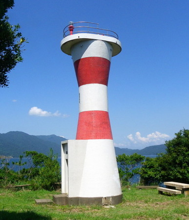
1967. Active; focal plane 23 m (75 ft); red flash every 4 s. 11 m (36 ft) round hourglass-shaped concrete tower, painted with red and white horizontal bands. Wikimedia has Fujitani Yoshihide's photo (seen at right), Lighthouses of Japan has a page for the station, Lighthouse-Japan.com has a page with good photos, Trabas has a closeup, Misty's Tour has a photo, FOAL has additional photos, Shoichi Tsutsui has a 2018 closeup, and Google has a satellite view. The peninsula of Nokogiri Saki has a hook pointing southeastward at the end; this lighthouse is located on a small island just off the tip of this hook, guiding ships into Kohama Bay. Accessible by road and a short walk that crosses to the island on a bridge. Parking is available, Site open, tower closed. . ARLHS JPN-010; JCG-1036; Admiralty M7252.4; NGA 2560.

Obama City Lighthouses
Obama Kō (West Breakwater)
Date unknown. Active; focal plane 10 m (33 ft); three green flashes every 12 s. 8.5 m (28 ft) round hourglass-shaped concrete tower. Entire lighthouse is white. Trabas has a closeup photo, FOAL also has a closeup (bottom left on the page), and Google has a sea view, a satellite view and a distant street view. Located at the south end of the detached breakwater sheltering Obama harbor. Accessible only by boat. Site open, tower closed. ARLHS JPN-1201; JCG-1037; Admiralty M7252.8; NGA 2564.
Obama Kō North Breakwater
Date unknown. Active; focal plane 11 m (36 ft); green flash every 3 s. 10 m (33 ft) round cylindrical concrete tower with gallery. Entire lighthouse is white. Trabas has a closeup photo, FOAL also has a closeup (bottom right on the page), and Google has a street view and a satellite view. Located at the west end of a detached breakwater at the north end of Obama harbor. Accessible only by boat. Site open, tower closed. ARLHS JPN-1200; JCG-1038; Admiralty M7252.7; NGA 2568.
* Tagarasu (Takarasu) Kō (Myozin Hana, Myojin Hana)
1965. Active; focal plane 24 m (79 ft); two white flashes every 6 s. 8.5 m (28 ft) round hourglass-shaped concrete tower. Entire lighthouse is white. Lighthouse-Japan.com has a page with photos, FOAL is a page with photos, Wikimedia has Fujitani Yoshihide's closeup photo, Trabas has a photo, Tanaka Masayoshi also has a closeup, Misty's Tour has photos, and Google has a satellite view. Located on a promontory on the north side of the harbor of the fishing village of Tagarasu, about 10 km (6 mi) northeast of Obama. Accessible by a paved walkway from the village; a steep flight of stairs climbs to the lighthouse. Site open, tower closed. . ARLHS JPN-608; JCG-1039; Admiralty M7251.6; NGA 2572.
Akaguri Saki Light
Akaguri Saki Light, Ōi, July 2011
Wikimedia Creative Commons photo by 藤谷良秀 (Fujitani Yoshihide)

Mihama Town Lighthouses
Kuro Guri (Kurogiri)
Date unknown. Active; focal plane 13 m (43 ft) white light, 3 s on, 3 s off. 9 m (30 ft) concrete post attached to a square 1-story equipment shelter. Entire lighthouse is white. Trabas has a photo, Lighthouse Visit has a page for the light, and Google has a satellite view and a very distant street view. Located on a detached rubblestone breakwater off the west side of the Tsunekami peninsula near Ogawa. Accessible only by boat. Site open, tower closed. ARLHS JPN-1194; JCG-1040; Admiralty M7251.4; NGA 2576.
* Tsunekami (Tunekami, Tsunegami) Misaki
1957. Active; focal plane 244 m (800 ft); white flash every 3 s. 10 m (33 ft) square cylindrical concrete tower with gallery, attached to a small 1-story concrete keeper's house. Lantern removed. Entire lighthouse is white. A Coast Guard photo is at right, Lighthouses of Japan has a page for the station, FOAL's page has photos, Lighthouse-Japan.com has a page with several good photos, Trabas has a drone view, Wikimedia has Fujitani Yoshihide's closeup photo, Misty's Tour has a 2004 photo showing the lighthouse with its lantern, Watanabe Yukito has a 2017 closeup, and Google has a satellite view. The lantern, seen in several of the photos, was removed in 2008 when the lighthouse was converted to solar power. Located at the end of a long, northwest-pointing peninsula about 16 km (10 mi) west of Mihama. Accessible by a short but steep hiking trail; the entrance to the trail is behind waterfront buildings, so local guidance may be needed. Site open, tower closed. . ARLHS JPN-692; JCG-1041; Admiralty M7251; NGA 2580.
Hunatōsi (Funatosi) Saki
1971. Active; focal plane 60 m (198 ft); white light, 3 s on, 3 s off. 10 m (33 ft) concrete post centered on a square 1-story concrete equipment shelter. Entire lighthouse is white. Lighthouses of Japan has a page for the station, the FOAL page has two distant photos, Wikimedia has Fujitani Yoshihide's distant photo, Trabas also has a distant view, and Google has a satellite view. Located on a promontory on the west side of the Tateisi Peninsula about 16 km (10 mi) northwest of Tsuruga. The Mihama Nuclear Power Plant blocks public access to this site. Site and tower closed. JCG-1045; Admiralty M7249; NGA 2596.

Tsunekami Misaki Light, Mihama
Japanese Coast Guard Tsuruga Office photo


Tsuruga City Lighthouses
* Tateisi (Tateishi) Saki
1891. Active; focal plane 122 m (400 ft); white flash every 10 s. 8 m (26 ft) round cylindrical stone tower with lantern, painted white. A Coast Guard photo is at right, Trabas has a good photo, Lighthouses of Japan has a page for the station, Lighthouse-Japan.com has a page with good photos, the FOAL page has good photos, a 2021 photo is available, Misty's Tour has photos, Lighthouse Visit has photos, and Google has a street view and a satellite view. This diminutive but historic lighthouse stands on the tip of the Tateisi Peninsula, which separates Mihama and Tsuruga Bays. Accessible by a hiking trail from the north end of the Tateisi waterfront. Limited parking is available. . ARLHS JPN-630; JCG-1047; Admiralty M7246; NGA 2600.
Tsuruga Kō Breakwater
Date unknown. Active; focal plane 14 m (46 ft); green light, 3 s on, 3 s off. 12 m (39 ft) round cylindrical concrete tower with lantern and gallery. Entire lighthouse is white. Trabas has a closeup photo, Lighthouse Visit has a photo, A. Kukuchi's 2021 view shows the mountains of the Tsuruga Peninsula in the background, and the lighthouse appears in a Google satellite view. Located at the end of the main breakwater of Tsuruga harbor. Site and tower closed. ARLHS JPN-1206; JCG-1051; Admiralty M7247; NGA 2604.

Minamiechizen Town Lighthouse
* Kaburaki (Kaburagi) Kō (No. 1 Breakwater)
Date unknown. Active; focal plane 13 m (43 ft); continuous green light with two more intense flashes every 10 s. 11 m (36 ft) round concrete tower with a flared top, attached to a small equipment shelter. Entire lighthouse is white. Trabas has a closeup photo, a 2022 photo is available, and Google has a street view and a satellite view. Located at the end of the main breakwater at Kaburaki, a fishing port at the northern entrance to Tsuruga Bay, 20 km (13 mi) southwest of Echizen. Accessible by walking the pier (not a short walk, however). Site open, tower closed. ARLHS JPN-1191; JCG-1055; Admiralty M7245; NGA 2624.

Echizen Town Lighthouses
* Karei (Krei) Saki
1961. Active; focal plane 47 m (154 ft); two white flashes every 10 s. 10 m (33 ft) square concrete post with gallery attached to a square 1-story concrete equipment shelter. Entire lighthouse is white. Lighthouse-Japan.com has a page with good photos, FOAL has another page for the lighthouse, Trabas has a drone view, Wikimedia has Fujitani Yoshihide's good photo, a 2019 closeup is available, and Google has a satellite view. Located on a sharp promontory about 35 km (22 mi) north of Tsuruga. A stairway is the start of a steep climb to the lighthouse from Komenoura. Site open, tower closed. ARLHS JPN-232; JCG-1057; Admiralty M7243.8; NGA 2632.

Tateisi Saki Light, Tsuruga
Japanese Coast Guard Tsuruga Office photo
Takasa (Echizen Shirahama Kō, #2 Breakwater) (2)
1993 (station established 1964). Active; focal plane 20 m (66 ft); continuous white light. 6.5 m (21 ft) square concrete tower; the light is shown through a square window. Entire lighthouse is white. The Coast Guard has a page for the lighthouse, Trabas has a photo, the FOAL page has several photos, Chie Ikeda has a closeup, and Google has a street view and a satellite view. The original light may have been on the breakwater, but the present light is on a ridge above the base of the pier. Located at Noji Misaki, about 1 km (0.6 mi) north of Karei Saki. It looks like a tough scramble over rocks to reach the light. Site open, tower closed. JCG-1058; Admiralty M7243.75 NGA 2636.
* Echizen (Etizen) Gyoko
Date unknown. Active; focal plane 16 m (52 ft); green light, 2 s on, 2 s off. 10 m (33 ft) round concrete tower with a flared top, attached to a small equipment shelter. Entire lighthouse is white. Trabas has a closeup photo and Google has a satellite view and a distant street view. Located at the end of the main breakwater of Echizen harbor. Accessible by walking the pier (not a short walk, however). Site open, tower closed. ARLHS JPN-1186; JCG-1063; Admiralty M7243.5; NGA 2666.
#Kokonogi (Kuro Jogatani) (1)
1957. Inactive since 2010 and removed soon thereafter. This was an approx. 8.5 m (28 ft) concrete post attached to a square 1-story concrete equipment shelter. Entire lighthouse was white. Google's satellite view confirms that the light has been removed. The active light (green light occulting once every 8 s) was moved to a post at the end of the Kokonogi breakwater. Formerly located on a rocky headland at the base of the Kokonogi breakwater, just south of Jogatani. Site open, tower closed. ARLHS JPN-1195. Active light: JCG-1067; Admiralty M7243; NGA 2668.
* Echizen (Etizen) Misaki
1940. Active; focal plane 133 m (436 ft); white flash every 15 s. 17 m (56 ft) round cylindrical concrete tower with lantern and gallery, attached to a small 2-story concrete keeper's cottage. Entire lighthouse is white. Yoshihide Fujitane's photo is at right, Trabas has a good photo, Lighthouses of Japan has a page for the station, Lighthouse-Japan.com has a page with photos, FOAL has a page with good photos, Misty's Tour has a photo, and Google has a street view and a satellite view. The lighthouse is surrounded by a popular botanical garden called Suisen Rando (Narcissus Land). The entrance from the coastal highway is well marked. Located on a prominent cape 11 km (7 mi) north of Karei Saki. Site open, tower closed. . ARLHS JPN-063; JCG-1069; Admiralty M7242; NGA 2676.
Echizen Misaki Light
Echizen Misaki Light, Echizen, April 2010
Wikimedia Creative Commons photo by Yoshihide Fujitane

Fukui City Lighthouses
* Shirahama Kō (Outer Breakwater)
Date unknown. Active; focal plane 11 m (36 ft); green light, 6 s on, 2 s off. 9 m (29 ft) round concrete tower with a flared top, attached to a small equipment shelter. Entire lighthouse is white. Trabas has a closeup photo and Google has a satellite view and a street view. Located at the end of the north breakwater of Shirahama harbor. Accessible by walking the pier. Site open, tower closed. ARLHS JPN-1202; JCG-1071; Admiralty M7241; NGA 2684.
* Takasu (Takanosu) Kō
Date unknown. Active (?); main light reported inactive since 2022; a continuous white spotlight (JCG-1075) illuminates a reef 120 m (400 ft) offshore. 8 m (26 ft) round concrete tower with a flared top, attached to a small equipment shelter. Entire lighthouse is white. Japanese Wikipedia has a page for the lighthouse, the Coast Guard also has a page, Trabas has a closeup photo, Wikimedia has Yoshihide Fujitane's 2010 photo, and Google has a street view and a satellite view. The Admiralty delisted this light in April 2022 but it's quite possible the spotlight remains in service. Located on a promontory at the narrow entrance to Takanosu harbor. Site open, tower closed. ARLHS JPN-1205; JCG-1074; ex-Admiralty M7240.5; NGA 2692.
* Fukui (Hukui) Kō South Breakwater
Date unknown. Active; focal plane 17 m (56 ft); red flash every 3 s. 10.5 m (34 ft) round concrete tower with a flared top, attached to a small equipment shelter. Entire lighthouse is red. Wikimedia has Yoshihide Fujitane's photo, Trabas has a photo, and Google has a satellite view. Located on the south (main) breakwater of Fukui harbor. Probably accessible by walking the pier. Site open, tower closed. JCG-1076; Admiralty M7240.4; NGA 2700.
Fukui (Hukui) Kō North Breakwater
Date unknown. Active; focal plane 16 m (52 ft); green light occulting once every 8 s. 13 m (43 ft) round cylindrical concrete tower with lantern and gallery. Entire lighthouse is white. Yoshihide Fujitane's photo is at right, Trabas has a photo, and Google has a satellite view. Located on the short north breakwater of Fukui harbor. Access is blocked by an industrial area. Site and tower closed but the lighthouse can be seen from a distance. ARLHS JPN-1190; JCG-1077; Admiralty M7240.3; NGA 2696.

Sakai City Lighthouses
Mikuni Kō North Breakwater
Date unknown. Active; focal plane 12 m (39 ft); continuous green light with a more intense flash every 4 s. 10 m (33 ft) concrete post attached to a square 1-story equipment shelter. Entire lighthouse is white. Wikimedia has Yoshihide Fujitane's closeup photo, Trabas also has a closeup photo, and Google has a satellite view. Located at the end of the detached north outer breakwater of Mikuni harbor, at the north end of the Sakai waterfront. Accessible only by boat. Site status unknown. ARLHS JPN-1196; JCG-1078; Admiralty M7240; NGA 2704.
Fukui North Breakwater Light
Fukui North Breakwater Light, Fukui, July 2011
Wikimedia Creative Commons photo by Yoshihide Fujitane
* Oshima
1954. Active; focal plane 39 m (128 ft); two white flashes every 9 s. 11 m (36 ft) concrete post attached to one corner of a rectangular concrete equipment shelter. Entire lighthouse is white. Lighthouses of Japan has a page for the station, Lighthouse-Japan.com has a page with photos, Lighthouse Visit has photos, Wikimedia has Yoshihide Fujitane's photo, Trabas has a drone view, Misty's Tour has a photo, and Google has a a street view and satellite view. Located on an island just off a cape about 5 km (3 mi) north of Hukui. The island is connected to the mainland by a footbridge and the light is accessible by a trail. Parking is available. Site open, tower closed. . ARLHS JPN-442; JCG-1080; Admiralty M7239.7; NGA 2712.

Information available on lost lighthouses:

Notable faux lighthouses:

Adjoining pages: North: Southern Ishikawa | West: Tottori and Tajima

Return to the Lighthouse Directory index | Ratings key

Posted February 28, 2007. Checked and revised December 9, 2023. Lighthouses: 40. Site copyright 2023 Russ Rowlett and the University of North Carolina at Chapel Hill.