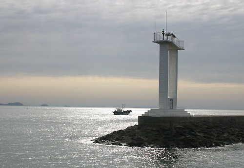
Lighthouses of South Korea: Okdo Islands, Gunsan

For most of its history Korea was an independent kingdom, or at least an autonomous kingdom under Chinese influence. This came to an end in 1910 when Japan annexed all of Korea. At the end of World War II in 1945 the 38° parallel was established as the dividing line between U.S. and Soviet zones of occupation, and in 1948 separate civil administrations were established in the two halves of the country. The Korean War (1950-53) ended in a draw with the armistice line falling close to the prewar 38° line. The Republic of Korea (ROK), commonly called South Korea (Daehan Minguk in Korean), occupies the Korean peninsula south of the armistice line.

South Korea is divided into nine provinces and eight province-level cities; the provinces are subdivided into counties and cities. This page covers lighthouses of Okdo Township in Gunsan City in Jeollabuk Province, located on South Korea's southwest coast in the region formerly known as Jeolla or Cholla. The Okdo Township includes several groups of islands in the Yellow Sea (usually called the West Sea in Korea) to the west and southwest of Gunsan. In particular, the Gogunsan Islands are summits along a ridge extending east to west and ending at Maldo. Bridges connect Sinsido, Munyeodo, Jangjado, and Seonyudo to Gunsan.

In 2000 South Korea adopted a Revised Romanization System to replace systems formerly used in the West. In the Revised System, the word for a lighthouse is deungdae (등대); dan (formerly tan) is a cape, seom (som) or do (to) is an island, am or amseog is a rock, man is a bay, and hang is a harbor. Some place names, including Gunsan (formerly Kunsan), may be more familiar to Westerners in the spellings of older systems.

Navigational aids in the ROK are regulated by the Ministry of Oceans and Fisheries (MOF). The lights in Gunsan are maintained by the Gunsan Regional Office of Oceans and Fisheries.

ARLHS numbers are from the ARLHS World List of Lights. KR numbers, where available, are from the Korean light list. Admiralty numbers are from volume M of the Admiralty List of Lights & Fog Signals. U.S. NGA List numbers are from Publication 112.

General Sources
Online List of Lights - Korea
Photos by various photographers posted by Alexander Trabas.
Navigational Beacon Management Office
Information from the Gunsan Oceans and Fisheries Office.
Navionics Charts
Navigation chart for western South Korea.


Eucheongdo (Ochongdo) Light
Gunsan Oceans and Fisheries Administration photo

Biando Lighthouses
Biando is an inhabited island about 12 km (7.5 mi) northwest of the Byeonsan coastline.
Biando Northeast
Date unknown. Active; focal plane about 10 m (33 ft); red light, pattern unknown. Approx. 9 m (30 ft) round cylindrical red concrete tower. No photo available but Google has a satellite view. Located at the end of a pier on the northeast coast of Biando. Probably accessible by walking the pier. Site status unknown. Admiralty M4206.79.
Biando Hang North Breakwater
Date unknown. Active; focal plane 10 m (33 ft); red flash every 4 s. 9 m (30 ft) round cylindrical red concrete tower. A photo is available and Google has a satellite view. Located at the original end of the north (main) breakwater of Biando. Probably accessible by walking the pier. Site status unknown. KR-3152.5; Admiralty M4206.81.
Biando East
Date unknown. Active; focal plane 17 m (56 ft); three quick white flashes every 10 s. 21 m (62 ft) round concrete tower painted black with one yellow horizontal band. No photo avalable but Bing has a satellite view. Located on a shoal about 1.8 km (1.1 mi) east of Biando harbor. Accessible only by boat. Site open, tower closed. KR-3152.6; Admiralty M4206.815.
Chidudo (Biando, Pian-do)
Date unknown. Active; focal plane 17 m (56 ft); white flash every 6 s. 10 m (33 ft) round cylindrical white concrete tower. Kihwan Kim's photo is at right and Google has a satellite view. Located on Chidudo, a skerry off the southeastern tip of Biando. Accessible only by boat. Site status unknown. KR-3152.3; Admiralty M4206.85; NGA 17746.5.
Saemangeum Breakwater South Head
Date unknown. Active; focal plane about 16 m (52 ft); yellow flash every 5 s. Approx. 14 m (46 ft) square concrete tower with lantern and gallery, painted yellow. No photo available but Google has a satellite view. Located at the south end of a long breakwater extending from north of Biando to south of Munyeodo. Accessible only by boat. Site open, tower closed. KR-3152.1; Admiralty M4206.376.

Chidudo Light, Biando, April 2023
Google Maps photo by Kihwan Kim
Saemangeum Breakwater North Head
Date unknown. Active; focal plane about 16 m (52 ft); red flash every 4 s. Approx. 14 m (46 ft) red tower. No photo available and the light is not seen in Bing's satellite view. Located at the north end of the Saemangeum Breakwater. Accessible only by boat. Site open, tower closed. KR-3152.19; Admiralty M4206.375.

Sinsido and Munyeodo Lighthouses
Sinsido is an island connected to Gunsan City to the north and to the Byeonsan coast of Buan County to the south by the Saemangeum Seawall, a 33 km (21 mi) long dike enclosing the tidal flats of of the Saemangeum estuary. Munyeodo is just west of Sinsido, connected by a bridge.

Dotomeorido (Sinsido Northwest
)
Date unknown. Active; focal plane 12 m (39 ft); green flash every 4 s. 15 m (49 ft) round green concrete tower. A drone view is available and Google has a satellite view. Located on a reef off the northwestern tip of Sinsido. Accessible only by boat. Site open, tower closed. KR-3162.5; Admiralty M4206.36.
Sinsido South
Date unknown. Active; focal plane 10 m (33 ft); three green flashes every 7 s. 17 m (56 ft) round concrete tower painted green. A drone view is available and Google has a satellite view. Located on a reef off the southwestern tip of Sinsido. Accessible only by boat. Site open, tower closed. KR-3162.6; Admiralty M4206.364.
Jageunyeo
Date unknown. Active; focal plane 13 m (43 ft); two green flashes every 6 s. 14 m (46 ft) round green concrete tower. A drone view and a distant drone view are available and Google has a satellite view. Located on a small island off the west side of Sinsido about 400 m (1/4 mi) north of the Gogunsan Bridge guiding ships in the channel between Sinsido and Munyeodo. Site status unknown. KR-3162.3; Admiralty M4206.361.
Songgeusyeo
2007. Active; focal plane 13 m (43 ft); two white flashes every 5 s. 10 m (33 ft) round cylindrical concrete tower painted black with one red horizontal band. A photo is at right, Lee Young Jae has a view of the lighthouse, a drone view is available, and Google has a satellite view. Located on a reef off the harbor of Munyeodo. Accessible only by boat. Site open, tower closed. KR-3161.6; Admiralty M4206.366.
Seogeunnyeo
2003. Active; focal plane 15 m (49 ft); six quick white flashes followed by one long white flash every 15 s. 19 m (62 ft) round cylindrical concrete tower; upper half of the tower painted yellow, lower half black. A drone view is available and Google has an indistinct satellite view. Located just off the southern tip of Munyeodo. Accessible only by boat. Site open, tower closed. KR-3161.1; Admiralty M4206.363.

Songgeusyeo Light, Munyeodo, November 2007
Gunsan Oceans and Fisheries Administration photo
Munyeodo Southwest
Date unknown. Active; focal plane 10 m (33 ft); nine quick white flashes every 15 s. 9 m (30 ft) round metal tower painted yellow with one black horizontal band. A drone view is available and Google has an indistinct satellite view. Located an a small island off the southwest coast of Munyeodo. Accessible only by boat. Site open, tower closed. KR-3161.8; Admiralty M4206.367.
Munyeodo West
Date unknown. Active; focal plane 16 m (52 ft); nine quick white flashes every 15 s. 18 m (59 ft) round cylindrical concrete tower painted green. A drone view is available, Hyeon Deok Han has a street view, and Google has a satellite view. Located on the west coast of Munyeodo beside the narrow chnnel separating that island from Seonyudo. Accessible only by boat. Site open, tower closed. KR-3161.7; Admiralty M4206.365.
Seonyudo (Munyeodo North)
Date unknown. Active; focal plane 10 m (33 ft); green flash every 5 s. 8 m (26 ft) octagonal green concrete tower with double gallery. A drone view is available and Bing has a satellite view. Despite being called Seonyudo by the Admiralty, this light is actually north of Munyeodo. Located on a reef the northern entrance to the passage between Munyeodo and Seonyudo. Accessible only by boat. Site open, tower closed. KR-3162; Admiralty M4206.3625.

Seonyudo and Jangjado Lighthouses
Seonyudo is west of Munyeodo, connected by a bridge. It is really two islands, Bukdo (North Island) and Namdo (South Island) connected by a long sandbar. Jangjado is west of Seonyudo, also connected by a bridge.

Seonyudo Northwest
Date unknown. Active; focal plane about 12 m (39 ft); green light, pattern unknown. Approx. 12 m (39 ft) round concrete tower painted green. Seungkwang Lee has a distant street view and Google has a satellite view. Located on a reef in a semicircular cove off the northwestern coast of Bukdo. Accessible only by boat. Site open, tower closed. Admiralty M4206.335.
 
* Seonyudo Hang Breakwater
Date unknown. Active; focal plane 12 m (39 ft); red flash every 5 s. 12 m (39 ft) rectangular red concrete tower fashioned to resemble a hand. A photo is at right, another excellent photo, a drone view, and a view along the pier are available and Google has a satellite view. Located on the breakwater at the harbor of Bukdo. Accessible by walking the pier. Site open, tower closed. KR-3162.1; Admiralty M4206.358.

Seonyudo Hang Breakwater Light, Okdo, March 2018
Google Maps photo by Jeong현덕
Dakseom
Date unknown. Active; focal plane about 12 m (39 ft); two green flashes every 6 s. Approx. 12 m (39 ft) round concrete tower painted green. A distant drone view is available and Google has a satellite view. Located on a reef off the east coast of Bukdo. Accessible only by boat. Site open, tower closed. KR-3161; Admiralty M4206.362.
Seonyudo Namdam
Date unknown. Active; focal plane 25 m (82 ft); white flash every 5 s. 10 m (33 ft); white round concrete tower. A distant drone view is available and Bing has a satellite view. Located on a cape at the southwestern tip of Seonyudo. Site status unknown. KR-3161.5; Admiralty M4206.37.
Seonyudo Southwest
Date unknown. Active; focal plane about 12 m (39 ft); nine quick white flashes every 15 s. Approx. 12 m (39 ft) round concrete tower yellow with a black horizontal band. A drone view is available and Google has a satellite view. Located on a reef off the southwestern coast of Namdo. Accessible only by boat. Site open, tower closed. KR-3162.9; Admiralty M4206.369.
Jangjado Northwest
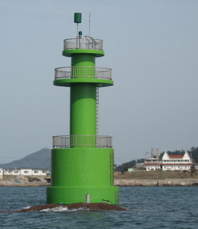
Date unknown. Active; focal plane 11 m (36 ft); green flash every 4 s. 15 m (49 ft) round cylindrical green concrete tower with double gallery. A photo is at right, the light is at the left in Jaiho Jung's 2016 photo, and Bing has a satellite view. Located on a reef off the harbor of Jangjado, a smaller island west of Namdo. Accessible only by boat. Site open, tower closed. Admiralty M4206.368.

Gwallido Lighthouses
Gwallido is separated from Jangjado by a channel about 1.6 km (1 mi) wide; it is accessible by ferry.

Heukdo (Heukseo)
Date unknown. Active; focal plane 19 m (62 ft); two white flashes every 10 s. 15 m (49 ft) round concrete tower, painted black with one red horizontal band. This light is on the left in a distant drone view and Google has a satellite view. Located on a reef about 450 m north of Gwallido. Accessible only by boat. Site open, tower closed. KR-3163.2; M4206.33; NGA 17753.1.
Golseo
2002. Active; focal plane 19 m (62 ft); two white flashes every 5 s. 22 m (72 ft) round concrete tower, painted black with one red horizontal band. This light is on the right in a distant drone view and Google has a fuzzy satellite view. Located on a reef about halfway between the northern tips of Gwallido and Daejangdo (about 1 km from each). Accessible only by boat. Site open, tower closed. Admiralty M4206.32; NGA 17753.
Jangjado Northwest Light
Jangjado Northwest Light, Okdo
Gunsan Oceans and Fisheries Administration photo
Hwanghae Lightfloat
2007. Active; focal plane 12 m (39 ft); five yellow flashes every 20 s. 12 m (39 ft) yellow tower atop a 10 m (33 ft) diameter lightfloat. The light is not shown in Google's satellite view. This facility is called the Central Ocean Observation Buoy. It takes observations for oceanographic research pursued by Korea jointly with the Chinese Joint Ocean Research Center. Located in the Yellow Sea about 60 km (37 mi) due west of Gwallido. Accessible only by boat. Site open, tower closed. Owner/site manager: Korea Ocean Research and Development Institute (KORDI). KR-3163.3; Admiralty M4206.5.

Maldo Islands Lighthouses
The Maldo village includes a chain of narrow islands, summits of a partly submerged ridge running east to west north of the Sinsido-Gwallido chain.
Maldo East Breakwater
Date unknown. Active; focal plane 18 m (59 ft); red flash every 5 s. 10 m (33 ft) round cylindrical concrete tower. Entire lighthouse is red. Park Byung-geun has a 2020 photo showing both breakwater lights, a more distant view is available, and Bing has a satellite view. Located on the short east breakwater of Maldo. Site status unknown. KR-3165; Admiralty M4206.15; NGA 17749.5.
Maldo West Breakwater
Date unknown. Active; focal plane 18 m (59 ft); green flash every 5 s. 10 m (33 ft) round cylindrical concrete tower. Entire lighthouse is white. Park Byung-geun has a 2020 photo showing both breakwater lights, a more distant view is available, and Bing has a satellite view. Located on the west breakwater of Maldo. Site status unknown. KR-3164; Admiralty M4206.1; NGA 17749.
* Maldo (3)
2007 (station established 1909). Active; focal plane 57 m (187 ft); white flash every 10 s. 26 m (85 ft) octagonal concrete tower with lantern and gallery. Lighthouse painted white. 1-story keeper's house and other light station buildings. A photo is at right, Doojin Choi has a 2021 photo, Kim Hyeoncheol has a 2019 photo, and Bing has a satellite view. This lighthouse functions as the landfall light for Gunsan (Kunsan), the principal port of Jeollabuk Province. The original lighthouse, installed under Japanese rule, was an octagonal cast iron tower; it was removed. The original lighthouse was replaced in 1989 by a round white concrete tower. Located on a small island about 35 km (19 mi) south southwest of the city. The island is accessible by ferry from Gunsan. Site open, tower closed. . ARLHS SKR-015; KR-3163; Admiralty M4206; NGA 17748.
Solpunseo (Solpunso)
Date unknown. Active; focal plane 15 m (49 ft); two white flashes every 10 s. 15 m (49 ft) tower, painted black with one red horizontal band. No photo available but Google has an indistinct satellite view. Located on a reef about 1.7 km (1 mi) east northeast of Maldo. Accessible only by boat. Site status unknown. Admiralty M4205.5; NGA 17751.
Sohoenggyeongdo (Sohoenggyongdo, Sohoenggyong Do)
Date unknown. Active; focal plane 30 m (98 ft); white flash every 4 s. 10 m (33 ft) hexagonal white concrete tower. No photo available but Bing has a satellite view. Located on the east side of a gap in the Okdo island chain. Accessible only by boat. Site status unknown. Admiralty M4206.3; NGA 17752.
Maldo Light
Maldo Light, Gunsan
Gunsan Oceans and Fisheries Administration photo
Hoenggyeongdo (Hoenggan Do)
Date unknown. Active; focal plane 54 m (177 ft); white flash every 6 s. 8 m (26 ft) round white concrete tower. No photo available but Bing has a satellite view. There are several Korean lighthouses called Hoenggando. Located at the east end of the same island that has the Sohoenggyongdo lighthouse at its west end. Accessible only by boat. Site status unknown. KR-3167; Admiralty M4206.35; NGA 17754.

Sibidongpado Lighthouse
Sibidongpado (Shibidonga Do)
Date unknown. Active; focal plane 91 m (299 ft); white flash every 7 s. 8 m (26 ft) round white concrete tower. No photo available but Google has a distant satellite view. The height of the lighthouse was increased by 3 m (10 ft) in 2012, perhaps by addition of a skeletal tower. Sibidongpado is the largest of a small group of islands about 30 km (19 mi) due west of the entrance to Gunsan harbor. Located on the highest point of the island. Site status unknown. KR-3168; Admiralty M4206.4; NGA 17812.

Gaeyado and Jukdo Lighthouses
Gaeyado is a small inhabited island, about 1.5 km (1 mi) in diameter, off the north side of the entrance to Gunsan harbor. Jukdo is a still smaller island about 1.5 km (1 mi) west of Gaeyado.

* [Gaeyado Hang]
Date unknown. Active; focal plane 12 m (39 ft); green flash every 6 s. 9 m (30 ft) steel post with gallery, painted white. Seongcheol Lim has a photo, the light is at the left in Seongcheol Lim's view across the harbor and Bing has a satellite view. Located on the south (main) breakwater of Gaeyado harbor. Probably accessible by walking the poer. Site open, tower closed. Admiralty M4190.715; NGA 17756.5.
Gunsan Janseo
Date unknown. Active; focal plane 12 m (39 ft); two white flashes every 5 s. 15 m (49 ft) round cylindrical concrete tower painted black with one red horizontal band. The light is right of center in a very distant view from Gaeyado and Google has a satellite view. Located on a reef about 1 km (0.6 mi) southeast of Gaeyado. Accessible only by boat. Site open, tower closed. Admiralty M4190.7.
Yeokgyeong (Yok'yong)
Date unknown. Active; focal plane 17 m (56 ft); white flash every 6 s. 12 m (39 ft) round cylindrical white concrete tower. No photo available but Google has a satellite view. Located on a small island about 800 m (1/2 mi) west of Jukdo. Accessible only by boat. Site open, tower closed. KR-3221; Admiralty M4191; NGA 17760.
Jukdo
Date unknown. Active; focal plane 15 m (49 ft); quick-flashing white light. 15 m (49 ft) round cylindrical concrete tower, upper half painted black and lower half yellow. No photo available but Bing has a satellite view. Located at the northern tip of Jukdo. Accessible only by boat. Site open, tower closed. KR-3221.5; Admiralty M4190.78; NGA 17760.4.
Cheonggangyeo
Date unknown. Active; focal plane 17 m (56 ft); nine quick white flashes every 15 s. 21 m (69 ft) round concrete tower painted yellow with one black horizontal band. No photo available but Google has a satellite view. Located on a shoal about 1 km (0.6 mi) north of Gaeyado. Accessible only by boat. Site open, tower closed. KR-3221.3; Admiralty M4190.75; NGA 17760.6.
Bakgeunyeo
Date unknown. Active; focal plane 16 m (52 ft); quick-flashing white light. 16 m (52 ft) round cylindrical concrete tower, upper half painted black and lower half yellow. No photo available but Bing has a satellite view. Located on a shoal off the northeast side of Gaeyado. Accessible only by boat. Site open, tower closed. KR-3221.4; Admiralty M4190.73; NGA 17760.8.

Yeondo Lighthouses
Yeondo (Yen-do) is a mountainous island about 25 km (15 mi) northwest of Gunsan.
Yeondo North Breakwater
Date unknown. Active; focal plane 16 m (52 ft); red flash every 7 s. 10 m (33 ft) round cylindrical concrete tower, painted red. A photo of both breakwater kightshouses is available, Incheol Shin has a distant street view, and Google has a satellite view. Located at the end of the north breakwater of Yeondo harbor, at the northeastern corner of the island. Site status unknown. KR-3223; Admiralty M4190.6; NGA 17806.
* Yeondo South Breakwater
Date unknown. Active; focal plane about 16 m (52 ft); light characteristic unknown. Approx. 15 m (49 ft) concrete tower; the light is on a mast atop a slanted platform supported by two rectangular pillars. Hyun-Tae Kim's photo is at right, another photo is available (a little over 1/3 the way down the page), and Google has an indistinct satellite view. Located at the end of the south breakwater at Yeondo. Probably accessible by walking the pier. Site open, tower closed. KR-3224; Admiralty M4190.5; NGA 17808.
Yeondo
Date unknown. Active; focal plane 194 m (636 ft); white flash every 5 s. 10 m (33 ft) round white concrete tower. No photo available but Bing has a distant satellite view. The height of the lighthouse was increased by 4 m (13 ft) in 2006, but it's not clear if this required a new tower or extension of the old one. Located on the highest point of the island. Site status unknown. KR-3222; Admiralty M4190; NGA 17804.
Yeondo Northwest
2021. Active; focal plane 11 m (36 ft); nine quick white flashes every 15 s. 13 m (43 ft) tower painted yellow with one black horizontal band. No photo available but Google has a satellite view. Located at the end of a rocky reef extending seaward from the northwestern corner of Yeondo. Accessible only by boat. Site open, tower closed. KR-3223.1; Admiralty M4189.99.
Yeondo South Breakwater Light
Yeondo South Breakwater Light, October 2004
ex-Panoramio photo copyright Hyun-tae Kim; used by permission

Eocheongdo (Ochongdo) Islands Lighthouses
Eocheongdo is the largest of a group of small islands located west northwest of Gunsan. These islands lie off the southwestern coast of South Chungcheong Province but they are attached administratively to North Jeolla Province. Eocheongdo is accessible by ferry from Gunsan.
Gajinseo (Kajinso, Kajin So)
Date unknown. Active; focal plane 29 m (95 ft); white flash every 6 s. 6 m (20 ft) round cylindrical white concrete tower with gallery. A photo is available, the light is seen in the background of a photo (second photo on the page) of the east breakwater lighthouse and Google has a distant satellite view. Located atop a skerry about 1.2 km (3/4 mi) southeast of the entrance to Eocheongdo harbor. Accessible only by boat. Site status unknown. KR-3233; Admiralty M4188.5; NGA 17818.
Eocheongdo (Ochongdo, U Chongdo) East Breakwater
Date unknown. Active; focal plane 29 m (95 ft); red flash every 4 s. 21 m (69 ft) round cylindrical concrete tower with lantern and gallery; the base of the lighthouse is surrounded by an octagonal platform. Entire lighthouse is red. Jong Kyu Kim's drone view is at right, another photo is available (second photo on the page), and Google has a satellite view. Located at the end of the short east breakwater protecting the narrow entrance to Eocheongdo harbor. Site status unknown. Admiralty M4188.7; NGA 17817.2.
* Eocheongdo (Ochongdo, U Chongdo) West Breakwater
Date unknown. Active; focal plane 18 m (59 ft); green flash every 5 s. 10 m (33 ft) round cylindrical concrete tower. Entire lighthouse is white. A photo (halfway down the page) shows both breakwater lighthouses, and Google has an indistinct satellite view. Located at the end of the west breakwater of Eocheongdo harbor. Accessible by walking the pier. Site open, tower closed. KR-3236; Admiralty M4188.3; NGA 17817.
* Eocheongdo Anchorage Breakwater
Date unknown. Active; focal plane 16 m (52 ft); two green flashes every 6 s. 12 m (39 ft) square cylindrical tower: four posts with gallery and a stairway spiralling around the tower. Entire lighthouse is white. A photo (third photo on the page) shows all three breakwater lighthouses, and Google has a satellite view. Located on an inner breakwater in Eocheongdo harbor. Accessible by walking the pier. Site open, tower closed. KR-3235; Admiralty M4189; NGA 17824.

Eocheondo East Breakwater Light, June 2018
Google Maps photo by Jong Kyu Kim
* Eocheongdo (Ochongdo, U Chongdo)
1912. Active; focal plane 61 m (200 ft); white flash every 12 s. 12 m (39 ft) concrete tower with lantern and gallery. Lighthouse painted white, but in a touch unusual for Korea the lantern dome is painted red. Fog siren (5 s blast every 45 s). A photo is at the top of this page, Kihwan Kim has a 2019 photo, Seunggil Lee has a 2023 photo, a blogger has several excellent photos, and Google has a satellite view of the station. This is one of the best known major lighthouses of Korea's west coast, and despite its remote location it is a popular tourist attraction with a vistor center and café. Located at the northwestern tip of Eocheongdo. Site open, tower closed. . ARLHS SKR-017; KR-3234; Admiralty M4188; NGA 17816.

Information available on lost lighthouses:

Notable faux lighthouses:

Adjoining pages: Northeast: Boryeong Area | East: Gunsan Area | Southeast: Gochang and Buan Counties

Return to the Lighthouse Directory index | Ratings key

Posted January 9, 2008. Checked and revised April 28, 2023. Lighthouses: 44. Site copyright 2023 Russ Rowlett and the University of North Carolina at Chapel Hill.