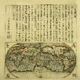
Matteo Ricci, the first Jesuit missionary to become adept in Chinese, produced a map of the world, on Western principles, in Chinese. The Ricci map went through several versions from 1574 to 1603 and profoundly influenced western cartography. Although East Asia--and China in particular--is represented clearly and with scientific precision, nevertheless several of China's own cartographers, writing independently of the court, criticized the configuration as an insult to China's centrality. Sometime in the 1620s Giulio Aleni had this abridgment of Ricci's map printed and hand-tinted. Aleni's name is in the left-most column of Chinese on the upper half, above the Jesuit seal.
Barb. or. 151, fasc. 1a china01 HG.03

Giulio Aleni, the equally skilled and effective successor to Matteo Ricci in China, supervised this wood-block printing of a book on the wonders of the western world, titled literally "An Illustrated Explanation of Geography." Here we see the Colossus of Rhodes, guarding that Mediterranean harbor, an image quite familiar to westerners from both classic and popular archaeology. The Chinese book shown here does not represent the best of Chinese wood-block engraving but appears to be a cheap printing (there is no publishing information given). It was probably sponsored by one of the churches that Aleni fostered in Fukien, where low-cost and quick printing abounded.
Borg. cin. 350, fasc. 30 fols. 75-76 china02 HG.09

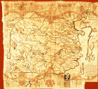
The Jesuit Michael Boym based his album of eight maps of China on his own experience of the country and on Chinese gazetteers. The opening page of his impressive album features the entire East Asian subcontinent. Although it does not depict the Korean- Japanese configuration with scientific accuracy, it does give details of China's river and mountain systems. According to a Vatican colophon, the work was purchased in 1729 by someone named Riamonteger and was later deposited in the Borgia collection.
Borg. cin. 531 general map HG.11

This letter was written in 1621 by Japanese officials who identify themselves as being from Gokinai, a word that referred to five imperially controlled districts around the capital at Edo, near Tokyo. Such officially attached lands were traditional bureaucratic institutions, not natural market or temple towns. Thus the signers would have been speaking as functionaries, not as residents of a town. They offer praise to the Catholic religion. A Latin translation is given on the same sheet.
Barb. or. 152, fasc. 3 china04

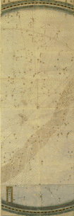
Adam Schall was the first European ever to have been a member of the court bureaucracy in Peking. As part of his duties as head of the Office of Astronomy, he produced this large and truly spectacular six-part cosmological map, accompanied by pictures of astronomical instruments.
NOTE:This is only one part of the map. For the complete view you can go the the Map Room.
Barb. or. 149 china05 HG.07

Venice: Donatus Bertelli, 1567
Abraham Ortelius's "New Map of Asia," of which a detail is shown here, was printed in 1567 on two flat sheets and shows the state of European knowledge of Asia before the Jesuit mission. Ortelius included traditional terms and images drawn from Marco Polo and other old sources, Tartar and Scythian place-names, renditions of the desert tents of Mongolian Great Khans, and the locations of Inner Asian states, such as Tibet and Tangut, that fought the Mongols in the thirteenth and fourteenth centuries. Much of north Asia is left blank, and there is no Korea. Two names are used at once for China: "Cataio" (central and central- western China) and "China" (the south). Quinsai and Zaiton, richly described by Polo, are displaced to the north. Ortelius places a pair of lions in the Chinese heartland, but his map lacks the corresponding lavish flora and fauna evident in Michael Boym's later work.
Stamp. geogr. I 9 china06 HG.17
