Lighthouses of Argentina: Río Negro

Argentina (officially the Argentine Republic, República Argentina) is the second largest country of South America and has a population approaching 50 million. Located on the southern east coast of the continent, Argentina has a lengthy coastline on the South Atlantic Ocean, extending from the warm waters of the Río de la Plata to the edge of the cold Southern Ocean.

Colonized by Spain in the mid 1500s, Argentina secured its independence and territorial integrity in series of uprisings between 1810 and 18i6. Several decades of controversy and conflict established the organization of the country and its borders with its neighbors to the north. Between 1878 and 1884 Argentina expanded its control southward, occupying the region of Patagonia east of the Andes Mountains.

Argentina is a federation of 23 provinces (provincias) plus the autonomous capital city of Buenos Aires. This page includes lighthouses of the central part of mainland Argentina's South Atlantic coast in Río Negro Province. Río Negro include the northern section of Argentine Patagonia. Its coast faces the San Mateias Gulf, a large embayment of the South Atlantic. The province is divided into counties called departments (departamentos).

The Spanish word for a lighthouse is faro; smaller lighthouses are often called balizas (beacons). In Spanish isla is an island, cabo is a cape, punta is a promontory or point of land, péñon is a rock, arrecife is a reef, bahía is a bay, ría is an estuary or inlet, estrecho is a strait, río is a river, and puerto is a port or harbor.

Active lighthouses in Argentina are owned by the Argentine Navy and managed by the Navy's Servicio de Hidrografía Naval (SHN).

ARLHS numbers are from the ARLHS World List of Lights. Admiralty numbers are from volume G of the Admiralty List of Lights & Fog Signals. U.S. NGA List numbers are from Publication 110, except for lights of the Beagle Channel, which are from Publication 111. The official Argentine light list, Faros y Señales Marítimas, is not available online.

General Sources
Faros de Argentina
Index to lighthouse articles and photos in the Spanish Wikipedia.
Faros Argentinos
Information and photos from the Argentine-based Faros del Mar website.
Lighthouses in Argentina
The ARLHS listing of Argentine lights; the society has photos for most of them.
Online List of Lights - Argentina - East Coast
Photos by various photographers posted by Alexander Trabas.
Faros Argentina
Photos posted on Flickr.com by Carlos María Silvano. Several of his photos appear with his permission on this page.
World of Lighthouses - Argentina
Photos by various photographers available from Lightphotos.net.
Lighthouses in Argentina
Photos by various photographers available from Wikimedia.
Leuchttürme Südamerikas auf historischen Postkarten
Historic postcard views posted by Klaus Huelse.
GPSNauticalCharts
Navigational chart information for Argentina
Google Maps
Satellite view of the Río Negro coastline.


Río Negro Light, Viedma, May 2020
Instagram photo by Florian von der Fecht
Adolfo Alsina Department (Viedma Area) Lighthouses
** Río Negro ("Faro de la Boca")
1887. Active; focal plane 43.5 m (143 ft); two white flashes every 20 s. 16.5 m (54 ft) round cylindrical brick tower with lantern and gallery rising from the center of a hexagonal 1-story brick keeper's quarters. Entire lighthouse painted white. A 2020 photo by Florian von der Fecht is at the top of this page, Trabas has Silvano's 2012 photo, Walter Ibañez has a 2018 photo, Claudio Conty has a 2022 drone view, Wikimedia has a photo of the station, and Google has a 2024 street view and a satellite view. The light station is staffed. This is Argentina's oldest surviving lighthouse and the first one to be built on the coast of Patagonia. The area is known locally as La Boca (the mouth), referring to the mouth of the Río Negro, which forms the boundary between Río Negro and Buenos Aires Provinces in the coastal region. However the river is not navigable, so the lighthouse acts instead as a landfall light for the Golfo San Matías to the south. At the beach close to the lighthouse is a memorial to Argentine service members killed in the Malvinas (Falklands) War of 1982. The lighthouse was opened to visitors starting in 2017. Located on the west side of the mouth of the Río Negro, adjacent to the El Cóndor resort; accessible via provincial route 1 from Viedma, the provincial capital. Site open, lighthouse and tower open Friday, Saturday and Sunday. . ARLHS ARG-012; Admiralty G1028; NGA 19588.
Belén
1928. Inactive since 1992. 14 m (46 ft) square pyramidal steel skeletal tower formerly with a black and white slatted daymark. Lantern removed. Lucas Pedrazzi has a 2016 photo, ARLHS has a photo, and Google has a satellite view. Located on the Península Belén, at the northern entrance to the Golfo San Matías, about 110 km (70 mi) west of Viedma. Site open, tower closed. Owner/site manager: unknown. ARLHS ARG-069; ex-Admiralty G1030.

San Antonio Department Lighthouses
San Antonio Oeste is a port town with a population of about 16,000 located at the northwestern head of the Golfo San Matías, an elliptical bay sheltered on the south by the Península Valdés. Three ranges guides ships into the harbor area.

*
San Matías
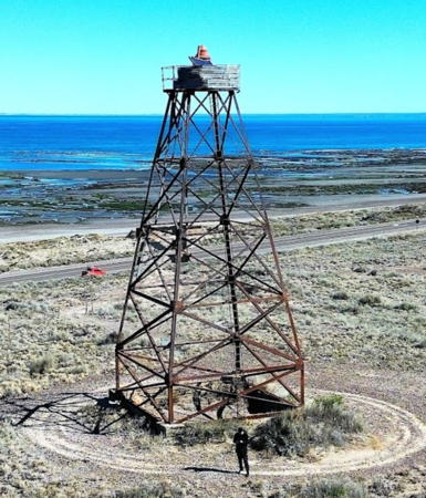
1924. Active; focal plane 42 m (138 ft); two white flashes every 11 s. 16 m (52 ft) square pyramidal steel skeletal tower, formerly with a black and white slatted daymark. The lantern was removed in 1974 and the light is displayed from a platform at the top of the tower. Héctor José Seitune's 2023 photo is at right, Trabas has Silvano's 2011 photo, Leandro Cottet has a 2021 photo, Lightphotos.net has a photo, Jorge Luis Bilbao has a photo, and Google has a satellite view. The lighthouse is built atop an artificial dune: a large conical mound. The surrounding area is a nature preserve, the Área Natural Protegida Bahía de San Antonio. Located off National Route 3 on the northeast side of the Golfo San Matías, perhaps 30 km (20 mi) east of San Antonio Oeste. Site open, tower closed. . ARLHS ARG-064; Admiralty G1031; NGA 19596.
Pedro García Range Front
Date unknown. Active; focal plane 28 m (92 ft); white flash every 1.5 s. 12 m (39 ft) square skeletal tower carrying a black and white slatted daymark. No photo available but Google has a satellite view. This is the approach range guiding vessels arriving at San Antonio Oeste. Located on the shore about 2 km (1.3 mi) south of San Antonio Oeste. Site status unknown. Admiralty G1034; NGA 19599.
* Pedro García Range Rear
Date unknown. Active; focal plane 39 m (128 ft); green flash every 3 s. 24 m (79 ft) round water tank, painted with vertical black and white stripes. Trabas has Silvano's 2012 photo, Cándido Héctor García has a photo, and Google has a 2024 street view and a satellite view. Located on a peninsula sheltering the harbor. Accessible by road. Site open, tower closed. ARLHS ARG-138; Admiralty G1035; NGA 19601.
Punta Villarino
1911. Active; focal plane 34 m (112 ft); white flash every 6 s. 7 m (23 ft) triangular skeletal tower. Martin Mendoza has a closeup 2023 photo, Claudio Alberto Castro has a 2022 closeup, Daniel Ramallo has a 2013 photo, ARLHS has a photo, and Google has a satellite view. Located on tip of the peninsula sheltering the harbor of San Antonio Oeste. Site open, tower closed. ARLHS ARG-072; Admiralty G1038; NGA 19598.
Cangrejal Inner Range Front
Date unknown. Active; focal plane15 m (49 ft); white flash every 2 s. 15 m (49 ft) square skeletal tower carrying an orange rectangular daymark panel. Trabas has Silvano's distant view but the tower is not seen in Google's satellite view. This the third range for San Antonio Oeste harbor. Located in a marsh east of the port, 4 km (2.5 mi) south of the rear light (next entry). Site status unknown. Admiralty G1042; NGA 19612.

San Matías Light, San Antonio Oeste, August 2023
Google Maps photo by Héctor José Seitune
* Camino (Cangrejal Inner Range Rear)
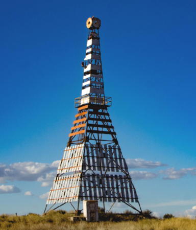
Date unknown. Active; focal plane 24.5 m (80 ft); red flash every 4 s. 23 m (75 ft) square pyramidal skeletal tower carrying a slatted daymark painted white with red bars in the center. A 2021 photo is at right, Trabas has Silvano's 2012 photo, and Google has a 2024 street view and a satellite view. This is an entrance range for San Antonio Oeste. Located just off National Route 3 on the north side of the Bahía San Antonio. Site open, tower closed. Admiralty G1042.1; NGA 19616.
Banco Reparo Range Front
Date unknown. Active; focal plane 15 m (49 ft); white flash every 2 s. 15 m (49 ft) square skeletal tower carrying several daymarks including a triangular daymark point up. No photo available but Google has a distant satellite view. This is the second range for San Antonio Oeste. Located in a shallow area off the west side of the entrance channel. Accessible only by boat. Site open, tower closed. Admiralty G1036; NGA 19604.
* Banco Reparo Range Rear
Date unknown. Active; focal plane 41 m (135 ft); red flash every 3 s. 24 m (79 ft) square cylindrical skeletal tower. The front of the tower has a daymark of black and white bars. Trabas has Silvano's 2012 photo and Google has a satellite view and a distant street view. Located on a peninsula about 5 km (3 mi) southeast of San Antonio Oeste. Accessible by road. Site open, tower closed. ARLHS ARG-149; Admiralty G1037; NGA 19608.
* Las Grutas
Date unknown. Active; focal plane 71 m (233 ft); white light, 1 s on, 1 s off. 30 m (98 ft) round cylindrical water tank. Google has a street view and a satellite view. Located in Las Grutas, a beach resort town about 15 km (9 mi) south of San Antonio Oeste. Site open, tower closed. ARLHS ARG-115; Admiralty G1045; NGA 19626.
Punta Colorada
Date unknown. Reactivated; focal plane 54 m (177 ft); white light, 2 s on, 2 s off, 2 s on, 4 s off. Light mounted on a large industrial building. Martin Garmendia has a photo and Google has a satellite view. This light guides vessels arriving to load iron ore at a facility formerly abandoned but recently revived by a Chinese company. Located at Punta Colorada, about 100 km (60 mi) south of Las Grutas. Site status unknown. Admiralty G1046.3; NGA 19628.

Camino Light, San Antonio Oeste, March 2021
Google Maps photo by Ground Training

Information available on lost lighthouses:

Notable faux lighthouses:

Adjoining pages: North: Buenos Aires | South: Chubut

Return to the Lighthouse Directory index | Ratings key

Posted December 2003. Checked and revised September 22, 2025. Lighthouses: 12. Site copyright 2025 Russ Rowlett and the University of North Carolina at Chapel Hill.