Lighthouses of Southeastern Brazil

The Federative Republic of Brazil (Brasil in Portuguese), the largest country in South America and fifth largest in the world, has a lengthy coastline, a large number of lighthouses, and a distinguished lighthouse history. Colonized by Portugal, Brazil declared its independence in 1822. Uniquely among American nations it was a monarchy as the Empire of Brazil until 1889.

Brazil is a federal republic with 26 states and a federal district. This page covers the lighthouses of Brazil's southeastern states of São Paulo and Paraná. This coast includes the major port of Santos. For the most part, the coastline features beautiful sandy beaches framed by steep, sometimes mountainous headlands with a scattering of offshore islands.

The Portuguese word for a lighthouse is farol, plural faróis. In Brazilian use, the word farol generally applies to all light towers, regardless of whether they are enclosed structures or not. The word farolete or farolim is sometimes used for smaller towers. In Portuguese ilha is an island, ilhéu is an islet, cabo is a cape, ponta is a promontory or point of land, rocha is a rock, recife is a reef, baía is a bay, estreito is a strait, rio is a river, and porto is a port or harbor.

Active lighthouses in Brazil are owned by the navy (Marinha do Brasil) and maintained by the Centro de Sinalização Náutica e Reparos Almirante Moraes Rego (CAMR) in the Diretoria de Hidrografia e Navegacão (DHN). Many of the larger lighthouses are staffed by resident keepers or by rotating crews of naval personnel. Only a small number of Brazilian lighthouses are open to the public.

ARLHS numbers are from the ARLHS World List of Lights. BR numbers are from the official Brazilian Lista de Faroís. Admiralty numbers are from volume G of the Admiralty List of Lights & Fog Signals. U.S. NGA numbers are from Publication 110.

General Sources
Faroís Brasileiros
This web site for Brazilian lighthouses has small photos and historical information for many of the major lights.
Online List of Lights - Brazil
Photos by various photographers, posted by Alexander Trabas. Most of the Brazilian photos are by Capt. Theo Hinrichs or Capt. Peter Mosselberger.
Lighthouses in Brazil
Photos by various photographers available from Wikimedia.
World of Lighthouses - Brazil
Photos by various photographers available from Lighthouses.net.
Lista de faróis do Brasil
Index to articles on the Portuguese Wikipedia.
Lista de Faróis
The official Brazilian light list.
Leuchttürme Südamerikas auf historischen Postkarten
Historic postcard views posted by Klaus Huelse.
GPSNauticalCharts
Navigational chart information for Brazil.


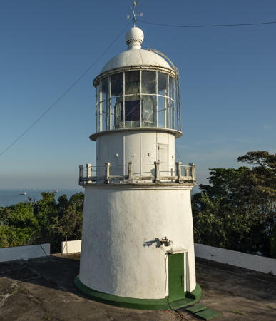
Ilha da Moela Light, Santos, June 2021
Wikimedia Creative Commons photo by Marinha do Brasil
Lighthouses of São Paulo State

The state of São Paulo is the most populous state in Brazil, with a population of more than 46 million. The state capital of São Paulo, the world's fourth largest city, is located about 70 km (44 mi) inland; Santos, a city of about half a million residents, is its port city.

Ilhabela Area Lighthouses
* [Ubatuba]
1932. Active; focal plane 65 m (213 ft); three white flashes every 10 s. 5 m (17 ft) post mounted on a short stone tower surrounded by a stone wall. A 2022 photo is available, Diego Fernando has a 2017 closeup photo, and Google has a street view and a satellite view. Located at the tip of the narrow Ponta Grossa peninsula sheltering the bay of Ubatuba. Accessible by road (inquire locally). Site open, tower closed. ARLHS BRA-206; BR-3160; Admiralty G0462; NGA 18560.
Massaguaçu
Date unknown. Active; focal plane 75 m (246 ft); two white flashes every 12 s. 5 m (16 ft) square white masonry tower. No photo available but Google has a satellite view. Located on a forested headland at Caraguatatuba. Site status unknown. ARLHS BRA-153; BR-3164; Admiralty G0464; NGA 18570.
Ilha de Vitória
Date unknown. Active; focal plane 101 m (331 ft); white flash every 6 s. 4 m (13 ft) square white concrete tower. No photo available and the light is barely visible in Google's satellite view. Located at the eastern tip of an island about 20 km (13 mi) east of the larger Ilha Ilhabela. Accessible only by boat. Site status unknown. ARLHS BRA-208; BR-3168; Admiralty G0466; NGA 18568.
São Sebastião
Date unknown. Active; focal plane 6 m (20 ft); red flash every 5 s. 6 m (20 ft) square masonry tower, painted red, on a concrete platform. No photo available but Bing has a satellite view. Located in the northern entrance to the Canal de São Sebastião, the strait separating the island of Ilhabela from the mainland. Accessible only by boat. Site open, tower closed. BR-3180; Admiralty G0472; NGA 18576.
* Ponta das Canas
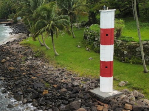
Date unknown. Active; focal plane 13 m (43 ft); white flash every 6 s. 11 m (36 ft) round cylindrical concrete tower, painted with red and white horizontal bands. Viny Godoy's 2024 photo is at right, Trabas has Jim Smith's photo, additional photos and a drone view are available, and Google has a satellite view. Located on a promontory on the northwestern coast of Ilhabela, a large island off the mainland town of São Sebastião. Accessible by road. Site open, tower closed. ARLHS BRA-233; BR-3184; Admiralty G0470; NGA 18572.

Ponta das Canas, Ilhabela, January 2024
Google Maps photo by Viny Godoy
[Ponta Grossa]
Date unknown. Active; focal plane 60 m (197 ft); white light, 2 s on, 13 s off. 10 m (33 ft) white square skeletal mast. Diego Almeida has a 2024 photo and Google has a satellite view. This light has been dropped by the Admiralty but it remains on the Brazilian list and is charted as active by C-Map. Located on the northestern corner of Ilhabela, a large island off the mainland town of São Sebastião. Site status unknown. ARLHS BRA-176; BR-3170; ex-Admiralty G0468; NGA 18571.
Ponta do Boi
1900. Active; focal plane 70 m (230 ft); white light, on 2.5 s, off 7.5 s. 17 m (56 ft) square cylindrical masonry tower with lantern and gallery, painted white. 3rd order Fresnel lens in use. Daniel Rocha da Silva has the August 2021 photo at right, a February 2021 photo by Carlos Siqueira shows the lighthouse just before it was repainted, Jefferson Flausino has a 2022 photo, Zigomar Monteaperto has a view from the sea, and Google has a satellite view. The lighthouse is in a state park, the Parque Estadual de Ilhabela. It took two years and some imaginative engineering to build the lighthouse at this remote location. Located atop a steep bluff on the southeastern tip of the large island of Ilhabela about 35 km (20 mi) southeast of São Sebastião. Site open, but the nautical museum calls the site quase que inacessível por terra, almost inaccessible by land. Tower closed. . ARLHS BRA-082; BR-3176; Admiralty G0484; NGA 18616.
Ponta da Sela
Date unknown. Active; focal plane 17 m (56 ft); three white flashes every 15 s. 11 m (36 ft) round cylindrical concrete tower, painted with red and white horizontal bands. Flavio Galibe has a photo and Google has an indistinct satellite view. Located at the western tip of the Ilha São Sebastião. Site status unknown. ARLHS BRA-287; BR-3264; Admiralty G0480; NGA 18612.
Pontinha
Date unknown. Active; focal plane 25 m (82 ft); red flash every 5 s. 10 m (33 ft) square pyramidal skeletal tower. Rogério Tenório hass a distant 2024 view from the sea, a distant drone view is available, and Google has a satellite view. This light guides ferries arriving at Ilhabela from the mainland. Located atop a steep forested ridge south of the terminal. There is parking nearby. Site status unknown. ARLHS BRA-236; BR-3240; Admiralty G0477; NGA 18588.
Toque-Toque
Date unknown. Active; focal plane 35 m (115 ft); white flash every 6 s. 10 m (33 ft) square white skeletal tower. No photo available but Bing has a satellite view. Located at the southern tip of an island at the west side of the southern entrance to the Canal de São Sebastião. Accessible only by boat. Site status unknown. ARLHS BRA-202; BR-3266; Admiralty G0479; NGA 18610.

Ponta do Boi Light, Ilhabela, August 2021
Google Maps photo by Daniel Rocha da Silva
Alcatrazes (Ilha do Porto) (2)
Date unknown (station established 1912). Active; focal plane 24 m (79 ft); white flash every 6 s. 7 m (23 ft) square pyramidal white concrete tower; a stairway spirals around the tower. Alvanir Oliveira has a photo and Google has an indistinct satellite view. Located on Ilha do Porto, a skerry in the Arquipelago de Alcatrazes, a group of small islands about 80 km (50 mi) southeast of Santos and a similar distance southwest of São Sebastião. Accessible only by boat. Site status unknown. ARLHS BRA-044; BR-3268; Admiralty G0490; NGA 18624.

Santos Lighthouses
Santos, the seaport of São Paulo state, was founded in 1546. Traditionally one of the world's most important coffee markets, it is now the busiest port in all of South America. The city has a population of about a half million. Most of it is on an island, the Ilha de São Vicente, with a broad beach facing south on the Baía de Santos. The port area is at the east end of the island and across the Rio de Meio on the mainland.

Ilha da Moela
1830. Active; focal plane 110 m (361 ft); light displays white 15 s, off 4 s, white 1.5 s, off 4 s, white 15 s, off 9.5 s, red 1.5 s, off 9.5 s. 10 m (33 ft) round masonry tower with lantern and gallery. 1st order Fresnel lens (1895) in use. Entire lighthouse painted white. A 2021 Navy photo is at the top of this page, Gilberto Amaral Pereira has a 2016 photo, Paulo Daniel contributed a 2013 photo, Thiago Teixeira has a good photo, Trabas has Capt. Peter's distant view, and Google has a satellite view. This is a staffed naval station including the lighthouse, communications facilities (1956), and a weather station (1953). Located on an island about 5 km (3 mi) southeast of the entrance to the Baía de Santos, the harbor of Santos. Site and tower closed (the entire island is a Brazilian Navy base). ARLHS BRA-043; BR-3288; Admiralty G0496; NGA 18636.
Ilha das Palmas
Date unknown. Active; focal plane 18 m (59 ft); red flash every 3 s. 4 m (13 ft) red post light mounted on the south corner of a 1-story fishing club building. Trabas has Capt. Peter's photo, a drone view is available, and Google has a satellite view. Located on a small island just offshore at the eastern entrance to the Baia dos Santos. The island is connected to the mainland by a footbridge. Site status unknown. Site manager: Clube de Pesca de Santos. BR-3292; Admiralty G0497; NGA 18640.
Rio de Meio Range Front
Date unknown. Active (?); focal plane 8 m (26 ft); quick-flashing white light. 7 m (23 ft) square cylindrical concrete tower. Tower painted with red and white horizontal bands. Trabas has Capt. Peter's photo and Google has a satellite view. It looks abandoned in the photo but it is still listed by the Admiralty and Brazilian lists and it is charted as active by C-Map. Located near the waterfront in Rio de Meio, a neighborhood on the southeast side of the Santos estuary. Site and tower closed. BR-3312; Admiralty G0501; NGA 18660.
Rio de Meio Range Rear
Date unknown. Active; focal plane 13 m (43 ft); white light, 1 s on, 1 s off. 13 m (43 ft) square cylindrical concrete tower with gallery and a square concrete lantern enclosure. Tower painted with red and white horizontal bands. The light has been moved atop the lantern. Trabas has Capt. Peter's photo and Google has a street view and a satellite view. Located beside Padre Amaldo Caiafa in Rio de Meio. Site status unknown but the light is easy to see from the street. BR-3316; Admiralty G0501.1; NGA 18664.
* Itapema (Alfândega)
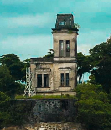
About 1908. Inactive since 1976. Approx. 12 m (40 ft) square cylindrical tower with attached keeper's cottage. Martinho Sargo has the 2023 photo at right, Claudio Milone has a photo, Maria Carambola has posted a photo, Andreas Köhler has a photo, and Google has a satellite view. This lighthouse is located in the Forte do Itapema, a sixteenth century fort largely destroyed by fire in 1883. In 1905 the building was transferred to the customs office (Alfândega), and in 1908 that office was directed to build a lighthouse tower with searchlights. In 1976 (some sources say 1975) the tower was itself gutted by fire. It is in poor condition. There are proposals to restore both the fort and the lighthouse as tourist attractions. Andreas Köhler visited in early 2009 and found no restoration in progress. Site open, tower closed. Located on an island on the east side of the Santos Estuary, across from the waterfront of Santos and close to a ferry terminal. Site status and management unknown. ARLHS BRA-140.
* Itapema Norte
1976(?). Active; focal plane 11 m (36 ft); red flash every 3 s. 8 m (26 ft) square skeletal tower, painted white. Trabas has Capt. Peter's photo, Martinho Sargo has the 2023 photo at right, the tower is seen in Maria Carambola's photo of the Forte do Itapema, and Google's satellite view. NGA lists the tower height as 14 m (46 ft), but this is clearly an error. Located in front of the Forte do Itapema (previous entry). Site open, tower closed. BR-3360; Admiralty G0502.4; NGA 18676.

Itapema Lights, Santos, March 2023
Google Maps photo by Martinho Sargo
* Ponta da Praia (Range Rear)
Date unknown (1960s?). Active; focal plane 13 m (43 ft); continuous light, white, red or green depending on direction. 12 m (39 ft) square concrete tower with gallery, painted with black and white horizontal bands. Tiago Rocha has a closeup, another photo is available, Trabas has Capt. Peter's photo, Wikimedia has Emilio Pechini's photo, and Google has a street view and a satellite view. This was originally the rear light of a range, but it has been converted to a leading (directional) light. Ruins of the old front light are visible offshore, as seen in Juan Reol's photo. Located near the east end of the beach in Santos, marking the north side of the entrance to the inner harbor. Site open, tower closed. ARLHS BRA-290; BR-3308; Admiralty G0499.1; ex-NGA 18656.
* Praia do Boqueirão Range Rear
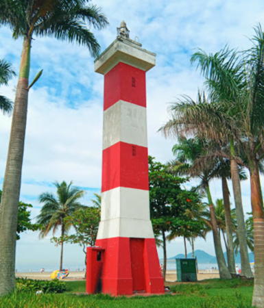
Date unknown (1960s?). Active; focal plane 17 m (56 ft); white light, 1 s on, 1 s off. 17 m (56 ft) square concrete tower with gallery, painted with red and white horizontal bands. Bruno Andrade's 2020 photo is at right, Daniel Pascoal has a fine photo, Trabas has Capt. Peter's photo, Wikimedia has a nice photo by Luc Móvel, Lívia Cunha also has a photo, and Google has a street view and a satellite view. This is the entrance range for the Baía de Santos. The front light is on a much shorter tower. Located in a park on the waterfront of Santos near the boulevard of Siqueira Campos. Site open, tower closed. ARLHS BRA-284; BR-3300; Admiralty G0498.1; NGA 18648.

Southwest Coast Lighthouses
Laje da Conceição
Date unknown. Active; focal plane 34 m (112 ft); two white flashes every 12 s. 6 m (20 ft) square concrete tower, painted red. Márcio Falcão has a 2023 view from the sea and Google has an indistinct satellite view. Located on a huge rock about 8 km (5 mi) off the coast of Itanhaem. Accessible only by boat. Site status unknown. ARLHS BRA-146; BR-3492; Admiralty G0506; NGA 18692.
Ilha Guaraú
Date unknown. Active; focal plane 67 m (220 ft); flah every 3 s, white or red depending in direction. 7 m (23 ft) cylindrical fiberlass tower. No photo available but Google has a distant satellite view. Located on a small island off a headland about 10 km (6 mi) south of Peruibe. Accessible only by boat. Site status unknown. ARLHS BRA-038; BR-3496; Admiralty G0509; NGA 18696.

Praia do Boqueirão Light, Santos, December 2020
Google Maps photo by Bruno Andrade
Ilha Queimada Grande
1909. Active; focal plane 82 m (270 ft); white flash every 10 s. 10 m (33 ft) square cylindrical concrete tower with gallery, painted white. A photo is available, Trabas has Capt. Peter's distant view, and Bing has a distant satellite view. Highly venomous snakes known as golden lanceheads are endemic to the island, discouraging visits by humans. As a result the island is a restricted environmental reserve. Located on one of the summits of a high island about 35 km (20 mi) southeast of Itanhaém. Site and tower closed. ARLHS BRA-086; BR-3500; Admiralty G0512; NGA 18700.
* Icapara
1991. Active; focal plane 73 m (240 ft); one long (2 s) white flash every 15 s. 10 m (33 ft) square skeletal tower with gallery. The tower also carries a diamond-shaped, vertically slatted daymark. Luciano Faustino has a closeup photo, Marcelo Braga Alves has a 2019 photo, a 2010 photo is available, and Google has a fuzzy satellite view. Located on a prominent headland at Icapara. Site open, tower closed. ARLHS BRA-135; BR-3502; Admiralty G0513.5; NGA 18702.
Ilha do Bom Abrigo
1886. Active; focal plane 146 m (479 ft); flash every 10 s, with two white flashes followed by a red flash. 16 m (52 ft) octagonal cylindrical masonry tower with lantern and gallery. Entire lighthouse painted white. Guto Santinelli has a closeup photo, Bárbara de Aquino also has a closeup, a distant view is available, Yutaka Abe has a distant street view, and Google has a satellite view. Located high atop the Ilha do Bom Abrigo, the "Island of Good Shelter," outside the entrance to the harbor of Cananéia. Accessible only by boat. Site status uncertain, tower closed. ARLHS BRA-013; BR-3508; Admiralty G0516; NGA 18704.

Lighthouses of Paraná

Mostly an inland state, Paraná has only a short coastline but its major port Paranaguá, a city of about 150,000 residents, is Brazil's seventh largest port.

Paranaguá Lighthouses
#Paranaguá Range C Rear
1954. Collapsed in 2007. This was a 14 m (46 ft) square concrete tower, formerly painted white with a red horizontal band. The lighthouse was leaning for many years. Alexandre Hartmann has a February 2006 photo and another photo was taken on New Year's Eve 2006. A December 2007 photo and Google's sea view and satellite view show the lighthouse lying on the beach. This light was not replaced because the entrance channel is now on the south side of the Ilha do Mel. Located on the southwestern tip of the Ilha de Peças, where it formerly guided ships around the north side of the Ilha do Mel into the Paranaguá estuary. ex-Admiralty G0526.1
Cassual
1904. Inactive; charted as a landmark. 15 m (49 ft) 4-story square masonry tower with castellated gallery; lantern removed. Lighthouse painted white. Getulio Vogetta has a 2022 photo, Andre Pimentel has a closeup photo and Google has a sea view and a satellite view. Located at the northern end of the Ilha do Mel, across the estuary entrance from the Paranaguá Range C lights. Probably accessible only by boat. Site open, tower closed.
* Ponta das Conchas (Ilha do Mel)
1872. Active; focal plane 67 m (220 ft); white flash every 10 s. 18 m (59 ft) round cast iron tower with lantern and gallery, painted white. Jorge Gobbi's photo is at right, A 2021 photo by Edgar Montelares is at right, Wikimedia has several good photos, Robert Wagner has a 2019 photo, Trabas has Capt. Peter's view from the sea, Silvio Moraes has a street view from the beach, and Google has a sea view, a street view and a satellite view. This is one of nine cast iron lighthouses prefabricated for Brazil by P & W McLellan of Glasgow, Scotland. The beautiful Ilha do Mel ("Honey Island"), located in the mouth of the Baía de Paranaguá, is a major tourist attraction easily accessible by ferry from Paranaguá or Pontal do Sul. The island is a state park and most of its interior is an ecological preserve. Located atop a steep headland at the northeastern tip of the Ilha do Mel. Accessible by a hiking trail popular for its spectacular views. Site open, tower closed. . ARLHS BRA-074; BR-3512; Admiralty G0520; NGA 18724.
Caraguatá (Farol das Encantadas)
Date unknown. Active; focal plane 43 m (141 ft); white flash every 6 s. 10 m (33 ft) square cylindrical concrete tower, painted white with one red horizontal band. Laudison Moraes dos Anjos has a closeup photo, Adriano Viana has a 2023 closeup, Trabas has a photo by Capt. Peter, Google has a sea view, and Google has a fuzzy satellite view. Located near the southern tip of the Ilha do Mel, marking the east side of the entrance to the channel leading to Paranaguá. Site open but not easy to reach; tower seems to be open. ARLHS BRA-023; BR-3550; Admiralty G0524; NGA 18726.

Ponta das Conchas Light, Ilha do Mel, November 2021
Google Maps photo by Edgar Montelares

Matinhos Lighthouse
Ilha Caiobá
Date unknown. Active; focal plane 27 m (89 ft); white flash every 5 s. 9 m (30 ft) tapered square skeletal tower, painted white. Aloisio Jaremtchuk has a photo of the base of the tower and Google has an indistinct satellite view. Located on the southern tip of an island off a promontory on the south side of Matinhos, marking the entrance to the neighboring city of Guaratuba. The island is connected to the mainland by a gravel bar. Site open, tower closed. ARLHS BRA-122; BR-3692; Admiralty G0538; NGA 18756.

Information available on lost lighthouses:

Notable faux lighthouses:

Adjoining pages: North: Eastern Brazil | South: Southern Brazil

Return to the Lighthouse Directory index | Ratings key

Posted January 30, 2004. Checked and revised August 1, 2024. Lighthouses: 27. Site copyright 2024 Russ Rowlett and the University of North Carolina at Chapel Hill.