Lighthouses of Chile: Pacific Islands

The Republic of Chile administers three groups of small islands in the eastern South Pacific Ocean, including several of the most remote and least well known islands of the world. These islands are known officially as the Islas Esporádicas (Sporadic Islands) or as Insular Chile. This pages lists the lighthouses built on those islands. The only inhabited islands are Easter Island (Isla de Pascua), the easternmost inhabited island of Polynesia, and Isla Robinson Crusoe in the Juan Fernández Islands. All the islands are administered as part of the Valparaíso Region.

There are no traditional lighthouses on these islands but there are some interesting minor aids to navigation. This page includes several of these lightbeacons.

The Spanish word for a lighthouse is faro; isla is an island, cabo is a cape, punta is a promontory or point of land, péñon is a rock, arrecife is a reef, bahía is a bay, ría is an estuary or inlet, estrecho is a strait, río is a river, and puerto is a port or harbor.

Chile's lighthouse agency, the Servicio de Señalización Marítima, is now an office within the ministry known as Directemar (Dirección General del Territorio Marítimo y Marina Mercante).

ARLHS numbers are from the ARLHS World List of Lights. Admiralty numbers are from volume G of the Admiralty List of Lights & Fog Signals. U.S. NGA List numbers are from Publication 111.

General Sources
Online List of Lights - Chile
Photos by various photographers posted by Alexander Trabas.
Lighthouses in Chile
Photos by various photographers available from Wikimedia.
World of Lighthouses - Chile
Photos by various photographers available from Lighthouses.net.
Navionics Charts
Navigation chart for Easter Island.
 
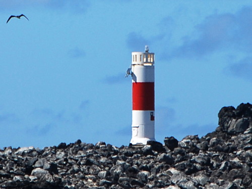
Sala y Gómez Light
Sala y Gómez Light, January 2006
Wikimedia Creative Commons photo by Government of Chile
Isla de Pascua Province: Easter Island Lightbeacons
Easter Island (known as Rapa Nui in Polynesian or Isla de Pascua in Spanish) is an isolated volcanic island 3510 km (2180 mi) west of the coast of central Chile. The island is triangular in shape, 24.6 km (15.3 mi) long by 12.3 km (7.6 mi) wide. Settled a thousand years ago by a Polynesian people, it had a population of 7750 in 2017. Tourists are attracted to the island to see the moai, its famous stone statues. The island is accessible by air from Chile, Peru, or Tahiti and it is visited frequently by cruise ships. It is administered as Isla de Pascua Province within the Valparaíso Region. In the Polynesian dialect spoken on the island hánga is a harbor.
* [Hánga Roa]
Date unknown. Active; focal plane 6 m (20 ft); red flash every 5 s. 3.5 m (11 ft) fiberglass post with daymark panels, colored white with a red horizontal band. Trabas has Thomas Philipp's closeup photo, Lightphotos.net has a photo, Carlos Linhares has a photo, and Google has a satellite view. Located at Hánga Roa, the principal settlement on the island, near the west end. Site open, tower closed. Site open, tower closed. Admiralty G1992; NGA 1152.5.
* [Hánga La Pérouse]
Date unknown. Active; focal plane 8 m (26 ft); white flash every 5 s. 3.5 m (11 ft) fiberglass post with daymark panels, colored white with a red horizontal band. Trabas has Carlos María Silvano's photo, Lightphotos.net has the same photo, and Google has a satellite view. Located at a tiny settlement on the north coast of the island. Site open, tower closed. Admiralty G1994; NGA 1153.
* [Hánga Hotuiti]
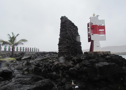
Date unknown. Active; focal plane 7 m (23 ft); white flash every 10 s. 3.5 m (11 ft) fiberglass post with daymark panels, colored white with a red horizontal band. Carlos María Silvano's photo is at right, Trabas has Erich Hartmann's closeup photo, Lightphotos.net has another photo by Silvano that also shows 15 of the moai, and Google has a satellite view. Located at a landing near the east end of the island. Site open, tower closed. Admiralty G1994.5; NGA 1154.
* [Desembarcadero Vaihú]
Date unknown. Active; focal plane 8 m (26 ft); white flash every 12 s. 5.5 m (18 ft) fiberglass post with daymark panels, colored white with a red horizontal band. Trabas has Michael Boucher's closeup photo and Google has a satellite view. The light marks a beach suitable for landing small craft. Located on the southwest side of Easter Island. Site open, tower closed. Admiralty G1995; NGA 1155.
Hotuiti Light
Hotuiti Light (with line of moai in left background), Easter Island, April 2013
photo copyright Carlos María Silvano; used by permission

Isla de Pascua Province: Salas y Gómez Lightbeacon
Salas y Gómez (named for two Spaniards who described their 1805 visit to the island) is a tiny island 390 km (242 mi) east northeast of Easter Island. The islanders call it Motu Motiro Hiva, and that is also the name of the marine reserve created by Chile in 2010 to protect the island and its surrounding waters, administered as part of the Isla de Pascua Province.

[Salas y Gómez (Sala y Gómez)]
1994. Active; focal plane 35 m (115 ft); white flash every 12 s. 6 m (20 ft) round cylindrical fiberglass tower, colored white with one red horizontal band. A photo is at the top of this page, Alain Hermes has a fuzzy distant view, and Google has a satellite view. The light is at the southern tip of the island. Accessible only by boat. Site open with proper permits, tower closed. Admiralty G1990.

Valparaíso Province: Archipiélago Juan Fernández Lightbeacons
The three Juan Fernández Islands are located about 600 km (375 mi) off the coast of central Chile. They are named for the Spanish navigator who discovered them in 1574. The Scottish sailor Alexander Selkirk was stranded on the largest island for four and a half years (1704-09), an adventure that may have inspired Daniel Defoe's 1719 novel Robinson Crusoe. In 1966 the island where Selkirk was stranded was renamed Isla Robinson Crusoe, and one of the other islands was named for Selkirk. Today Isla Robinson Crusoe has an airstrip and a permanent population of about 850. The islands are administered as a municipality (commune) of Juan Fernández within Valparaíso Province.

* [Punta San Carlos (2)]
Date unknown. Active; focal plane 6 m (20 ft); white flash every 12 s. 3.5 m (11 ft) fiberglass post with daymark panels, colored white with a red horizontal band. Trabas has Erich Hartmann's photo and Google has a distant satellite view. The earlier light is seen in the photo at right by Anibal Diaz and another 2009 photo by Marcelo Santander. Located on a promontory on the north side of the settlement on Isla Róbinson Crusoe, marking the entrance to the Bahía Cumberland. Site open, tower closed. ARLHS JFI-001; Admiralty G1855; NGA 1328.
[Isla Alejandro Selkirk]
Date unknown. Active; focal plane 9 m (30 ft); white flash every 10 s. 3.5 m (11 ft) fiberglass post with daymark panels, colored white with a red horizontal band. Lukas Mekis has a photo and Google has a distant satellite view. Located at the eastern point of the very rugged Isla Alejandro Selkirk, south of the island's tiny settlement. Site status unknown. Admiralty G1853; NGA 1331.5.

original Punta San Carlos Light, Isla Robinson Crusoe, January 2009
ex-Panoramio photo copyright Anibal Diaz; permission requested

Valparaíso Province: Islas de los Desventurados Lightbeacon
The Islas de los Desventurados (Unfortunate Islands) are four small volcanic islands located 850 km (530 mi) off the coast of northern Chile. There is no permanent population but the Chilean Navy maintains an airfield and a base on one of the islands, the Isla San Félix. The islands are administered as part of the Juan Fernández municipality within Valparaíso Province.

[Isla San Félix]
Date unknown. Active; focal plane 195 m (640 ft); flash every 12 s. 4 m (13 ft) round fiberglass tower, painted white with one red horizontal band. No photo available but Google has a satellite view. Andres Pacheco has an aerial view of the island; the light is just barely visible atop the peak at right. Located on the peak at the western tip of the island. Site status unknown. Admiralty G1937; NGA 1129.

Information available on lost lighthouses:

Notable faux lighthouses:

Adjoining page: East: Central Chile

Return to the Lighthouse Directory index | Ratings key

Posted October 5, 2012. Checked and revised August 28, 2023. Lighthouses: 0. Site copyright 2023 Russ Rowlett and the University of North Carolina at Chapel Hill.