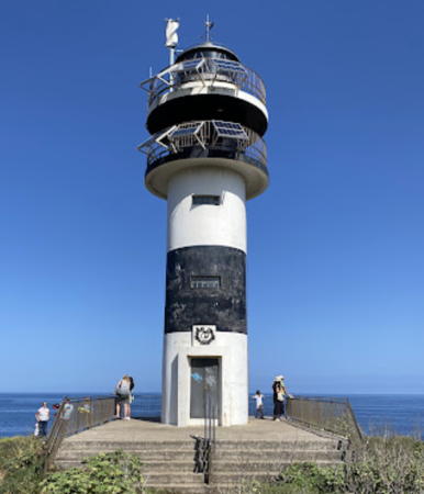
Lighthouses of Spain: Northern Galicia

The Kingdom of Spain occupies nearly 85% of the Iberian Peninsula in southeastern Europe with coastlines facing south and southeast on the Mediterranean Sea and southwest and northwest on the Atlantic Ocean. Spain also includes the Balearic Islands in the Mediterranean, the Canary Islands in the Atlantic, and the cities of Ceuta and Melilla on the north coast of Morocco.

Spain is divided into 17 regions called autonomous communities (comunidades autónomas). Galicia is an autonomous region in the northwestern corner of Spain. The Galician coastline is rugged and scenic but very dangerous to navigation; it is often called the "Coast of Death" (Costa da Morte in Galego). Many of the harbors are partly-sheltered bays called rías, actually the drowned lower valleys of rivers.

Galicia is divided into four provinces (provincias), which are subdivided into districts called comarcas. This page includes lighthouses of the north coast of the region in northern A Coruña Province and in Lugo Province.

Galicians speak Spanish or Galego, a distinctive language related to Portuguese. Galicia itself is called Galiza in Galego. The word for a lighthouse is faro in Spanish and farol in Galego, but its use is generally restricted to the larger coastal light stations. Smaller lighthouses are called balizas (beacons). In Galego illa is an island, cabo is a cape, punta is a promontory or point of land, rocha is a rock, arrecife is a reef, baía is a bay, ría is an estuary or inlet, estreito is a strait, río is a river, and porto is a port or harbor.

The navigational lights in Spain are the responsibility of the national port authority, Puertos del Estado, but many of them are operated and maintained by regional port authorities. The Comisión de Faros, founded in 1842 to build and maintain Spanish lighthouses, is now an advisory panel.

Most of the lighthouses listed on this page are maintained by the Autoridad Portuaria de Ferrol - San Cibrao. Lighthouses of the Ría de la Coruña are maintained by the Autoridad Portuaria de A Coruña.

ARLHS numbers are from the ARLHS World List of Lights. ES numbers are from the Spanish national list of lights, Libro de Faros. Admiralty numbers are from volume D of the Admiralty List of Lights & Fog Signals. U.S. NGA List numbers are from Publication 113.

General Sources
Libro de Faros y Señales de Niebla
Online edition of the official Spanish light list.
Online List of Lights - Spain Atlantic Coast
Photos by various photographers posted by Alexander Trabas. Eckhard Meyer contributed many photos from this area.
Faros de Galicia
A blog on Galician lighhouses posted by Marta Rivadulla.
Lighthouses in Spain
Excellent aerial photos posted by Marinas.com.
Lighthouses in Galicia
Photos by various photographers available from Wikimedia.
World of Lighthouses - Spain
Photos by various photographers available from Lightphotos.net.
Ayudas a la Navegación - Faros
Information posted by the Autoridad Portuaria de Ferrol - San Cibrao.
La Web de un Farero
A comprehensive web site on the lighthouses of Lugo and the Ferrol area.
Spain: Atlantic Coast
Historic photos and postcard images posted by Michel Forand.
Leuchttürme Spaniens auf historischen Postkarten
Historic postcard images posted by Klaus Huelse.
GPSNauticalCharts
Navigational chart information for Galicia.
i-Boating Charts
Navigational chart for Galicia.


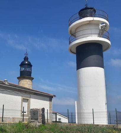
Old and new San Cibrao Lights, Cervo, May 2018
Instagram photo by kaorutakarai88


Cabo Prior Light, Ferrol, July 2020
Flickr Creative Commons photo by Jesús Pérez Pacheco
Lighthouses of Northern A Coruña Province

Eume District (Ría de Ares-Batanzos) Lighthouses
Playa de Cabanas (Cabañas)
Date unknown. Active; focal plane 9 m (30 ft); three red flashes every 9 s. 7 m (23 ft) octagonal cylindrical concrete tower, painted red with one narrow white horizontal band. Wikimedia has a photo by Luis Miguel Bugallo Sánchez, Trabas has Meyer's photo, Pepe Anacadabra has a 2022 photo, and Google has a satellite view. Located at the end of a partially-submerged jetty on the north side of the entrance to the Eume River in Cabanas. Site open, tower closed. ES-03528; Admiralty D1703.5; NGA 2537.5.

Southern Ferrol District (Ría de Ferrol) Lighthouses
Ferrol is a historic seaport; its excellent, well-sheltered and easily defended harbor has been a Spanish naval base for centuries. The city has a population of about 70,000.

*
San Martín Range Front
Date unknown. Active; focal plane 12 m (39 ft); white flash every 1.5 s. 8 m (26 ft) semicircular cylindrical cylindrical concrete tower. The tower is unpainted but the front face is covered with white tile. The light is shown through a small square opening near the top of the tower. Trabas has Helmut Seger's photo, Diego Cabaleiro Sabín has a 2021 photo, and Google has a street view and a satellite view. The range guides in the narrow throat of the harbor entrance. Located on a promontory on the south side of the Ría de Ferrol about 3 km (2 mi) west of El Baño. Accessible by hiking a seaside trail. Site open, tower closed. ARLHS SPA-364; ES-03260; Admiralty D1696; NGA 2476.
* San Martín Range Rear
Date unknown. Active; focal plane unknown; white light occulting once every 4 s. 13 m (43 ft) semicircular cylindrical cylindrical concrete tower. The tower is unpainted but the front face is covered with white tile. The light is shown through a small square opening near the top of the tower. Trabas has Meyer's closeup photo and Google has a satellite view. Located beside the coastal road on the south side of the Ría de Ferrol 700 m (0.44 mi) east of the front light. Accessible by hiking a seaside trail. Site open, tower closed. ARLHS SPA-365; ES-03261; Admiralty D1696.1; NGA 2480.
Castelo da Palma (Castillo de la Palma)
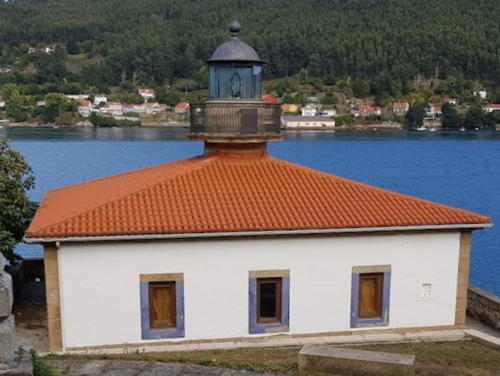
1862. Active; focal plane 11 m (36 ft); two long white flashes and one quick flash every 7 s. 7 m (23 ft) round stone tower with lantern and gallery centered atop a 1-story keeper's house. Tower unpainted; house painted white with a red roof. A photo is at right, Trabas has Helmut Seger's closeup photo, another closeup is available, Valentin Perez Rodriguez has a 2022 photo, and Google has a street view and a good satellite view. The Castillo de la Palma is one of several fortresses built to defend the port and naval base of Ferrol; the original fort was built in 1597 but the present structure dates from the late 1860s. The lighthouse is located on a promontory a short distance upstream (east) of the fort, on the south side of the Ría de Ferrol, about 1.5 km (1 mi) northwest of El Baño. A footpath leads down to the lighthouse; Google's 2009 street view shows the start of the path and a contractor's sign connected with a restoration then in progress. Accessible by road; limited parking is available a short distance south of the trailhead. Site open, tower closed. ARLHS SPA-061; ES-3300; Admiralty D1697; NGA 2484.
Ferrol Arsenal
Date unknown (station established 1865). Active; focal plane 11 m (36 ft); three red flashes, in a 2+1 pattern, every 12 s. 7 m (23 ft) post mounted atop a 1-story watchroom on the wall of a late medieval fort. Watchroom painted white; the post is painted red. Trabas has Helmut Seger's photo and Google has a satellite view. The historic Arsenal Militar de Ferrol is now the home of a naval museum. Located on the southernmost point of a large quay on the west side of the inner harbor of Ferrol. Site status unknown. Site manager: Museo Naval en Ferrol. ES-03400; Admiralty D1698.9; NGA 2516.

Castelo da Palma Light, Ferrol, October 2018
ex-Google Plus photo by El MKL
* Castelo de San Cristóbal
Date unknown. Inactive at least since 2008. 6 m (20 ft) round white concrete tower mounted on a square stone base atop the ruins of a fortification. the Castelo de San Cristobal. J.L Rodríguez has a 2023 photo, another photo is available, Manuel Dominguez has a more distant view, and Google has a satellite view. Located on a headland on the north side of the Ría de Ferrol, about 2.5 km (1.5 mi) west of San Felipe. Accessible by road but parking is limited. Site open, tower closed.
* Bateria de San Cristóbal
2008. Active; focal plane 33 m (108 ft); white, red or green light, continuous or flashing, depending on direction. 6 m (20 ft) square white concrete (?) tower. Trabas has Meyer's closeup photo and Google has a street view and a satellite view. This sophisticated 5-sector directional light guides vessels entering the Ría de Ferrol. Located on a headland on the north side of the Ría de Ferrol, about 300 m (0.2 mi) northwest of Castelo de San Cristóbal light. Accessible by road but parking is limited. Site open, tower closed. ARLHS SPA-007; ES-03250; Admiralty D1695; NGA 2468.
* Cabo Prioriño Chico
1854. Active; focal plane 36 m (118 ft); white flash every 5 s. 6 m (20 ft) octagonal stone tower with lantern and gallery, embedded in the front of a 1-story masonry keeper's house. Tower is unpainted stone; house and watch room painted white with unpainted stone trim; lantern dome painted white. A 2024 photo by Eugenio Morales is at right, Trabas has a fine closeup photo, a 2009 photo is available, Wikimedia has photos, and Google has a satellite view. This lighthouse stands at the end of a peninsula marking the entrance to the Ría de Ferrol and the approach to the harbor of Ferrol. The building was heavily damaged by vandals in 1990 and was out of service for several months; the optical equipment had to be replaced. It was replaced again in 1995, when the light was converted from gas to electric power and an acrylic Fresnel lens was installed. The light station commands a spectacular view of the Atlantic, the Ría de Ferrol to the northeast, and the Ría de Batanzos to the southeast. Located 15 km (9 mi) southwest of Ferrol. Accessible by road, parking provided. Site open, tower closed. . ARLHS SPA-039; ES-03240; Admiralty D1694; NGA 2464.

Cabo Prioriño Chico Light, Ferrol, August 2024
Google Maps photo by Eugenio Morales

Northern Ferrol District (Cabo Prior Area) Lighthouses
* Punta del Castro
Date unknown. Active; focal plane 44 m (144 ft); two white flashes every 7 s. 7 m (23 ft) trapezoidal cylindrical stone tower with a slanted roof carrying solar panels. Previously unpainted, the tower is now painted white. Tonec Noya has a 2023 photo, Trabas has a closeup photo, Rocío Álvarez Carballido has a 2019 closeup photo, and Google has a satellite view. Note that there is another Punta del Castro light at O Vicedo in Lugo Province (see below). Located on a promontory at O Priegal. Site open, tower closed. ARLHS SPA-098; ES-03235; Admiralty D1693.
* Cabo Prior
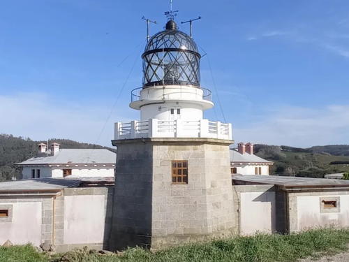
1853. Active; focal plane 107 m (351 ft); three white flashes in a 1+2 pattern every 15 s. 8 m (26 ft) hexagonal stone tower with lantern and gallery, embedded in the front of a U-shaped 1-story masonry keeper's house. The tower is unpainted stone; the house and watch room are painted beige with unpainted stone trim; the lantern dome is painted black. Jesús Pérez Pacheco's 2020 photo is at the top of this page, Trabas has a closeup photo, a 2008 photo and a 2021 photo are available, Wikimedia has several photos, Marinas.com has aerial photos, and Google has a street view and a satellite view. A stairway leads steeply down from the lighthouse to a narrow point of land overlooking the sea. Cabo Prior is the most prominent headland between Capes Finisterre and Ortegal, and the historic light here is an important landfall light for the ports of Ferrol and A Coruña. The lighthouse is at the top of a vertical cliff; a photo (halfway down the page) shows the view from the sea. Located 14 km (9 mi) northwest of Ferrol and 4 km (2.5 mi) northwest of Pedreira. Accessible by road, parking provided. Site open, tower closed. . ARLHS SPA-038; ES-03220; Admiralty D1692; NGA 2460.
* Punta Frouxeira
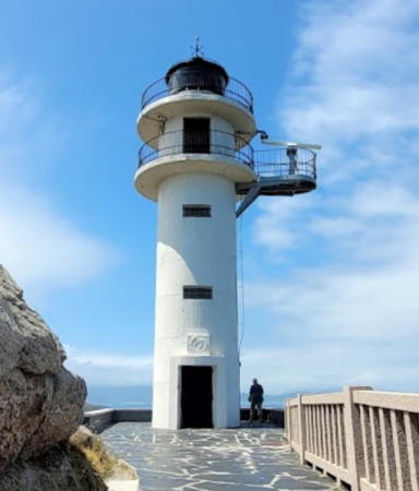
1994. Active; focal plane 75 m (246 ft); five white flashes every 15 s. 30 m (98 ft) square cylindrical skeletal concrete tower with enclosed watch room and a small lantern. The tower is unpainted white concrete, with inner walls covered in blue; originally green, the lantern is now blue. Jesús Pérez Pacheco's photo appears at right, José Manuel Rodriguez has a photo, Wikimedia has several photos, Trabas has Meyer's photo, Lois Fernandez has a 2009 photo, and Google has a street view and a satellite view. Close to beach resorts, this striking modern lighthouse is often photographed. Located on a headland about 5 km (3 mi) west of Valdoviño. Accessible by road, parking provided. Site open, tower closed. . ARLHS SPA-101; ES-03210; Admiralty D1690; NGA 2458.
Piedra de Media Mar
Date unknown. Active; focal plane 14 m (46 ft); two white flashes every 7 s. 13 m (43 ft) round cylindrical tower, painted black with one red horizontal band. Manual Garcia has a photo, Trabas has Meyer's photo, and Google has a satellite view. Located on a reef in the center of the Ría de Cedeira. Accessible only by boat.Site open, tower closed. ES-03195; Admiralty D1689.2.
Punta Promontorio (Cedeira)
1862. Active; focal plane 26 m (85 ft); white light occulting four times every 10 s. 8 m (26 ft) hexagonal tower with lantern and gallery, attached to a small 1-story keeper's cottage. Lighthouse painted white. Trabas has José de Palma's closeup photo, Pablo Pérez has a 2018 closeup, a 2021 photo is available, and Google has a satellite view. Located on a promontory in the middle of the Ría de Cedeira, about 2.5 km (1.5 mi) southwest of the town. Site status unknown; there doesn't seem to be a good land access to this site. ARLHS SPA-327; ES-03190; Admiralty D1688; NGA 2456.

Punta Frouxeira Light, Valdoviño, July 2020
Flickr Creative Commons photo by Jesús Pérez Pacheco
* Punta Sarridal (2?)
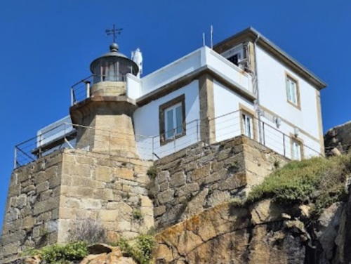
Date unknown. Active; focal plane 41 m (135 ft); white or red light depending on direction, 4 s on, 2 s off. 7 m (23 ft) round red barbell-shaped tower. Trabas has Meyer's photo, Jorge Sola Vitas has a 2018 street view, and Google has a satellite view. NGA lists a concrete tower. Located on a headland, a popular viewpoint, on the east side of Ria de Cedeira. ES-03192; Admiralty D1687.6; NGA 2454.
Punta Candieira (Candelaria)
1954. Active; focal plane 89 m (292 ft); four white flashes in a 3+1 pattern every 24 s. 9 m (30 ft) octagonal cylindrical tower with lantern and gallery, attached to a 1-story keeper's house. Lighthouse painted white with red trim. Trabas has Meyer's closeup photo, Jesús Rubio García's fine 2007 closeup shows the lighthouse freshly painted, and Google has a street view and a satellite view. This lighthouse was authorized in 1929 and completed in 1934, but it was not placed in service for 20 years. One writer attributes this delay to olvido burocrático (bureaucratic forgetfulness), but the Spanish Civil War and World War II probably played a role. In Trabas's photo it is clear the keeper's house is occupied. Located on a very steep point about 8 km (5 mi) north of Cedeira by a challenging road; 4WD recommended. Parking is quite limited. Site open, tower closed. . ARLHS SPA-202; ES-03170; Admiralty D1687; NGA 2452.

Ortegal District Lighthouses
* Cabo Ortegal
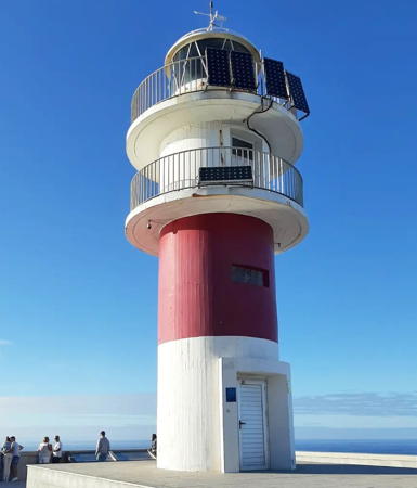
1984. Active; focal plane 124 m (407 ft); white light, 6 s on, 2 s off. 10 m (33 ft) round cylindrical concrete tower with lantern and double gallery, painted white with a red horizontal band below the lower gallery. A 2023 photo is at right, Trabas has Meyer's photo, Wikimedia has several photos, Virginia Carretero San Román has a 2021 photo, Marinas.com has aerial photos, and Google has a street view and a satellite view. Cabo Ortegal is 12 km (7.5 mi) west and a little south of Punta de la Estaca de Bares; it is the point where the Spanish coastline changes direction from east-west to northeast-southwest. A light was initially planned here in 1846 but mariners preferred Estaca de Bares. In 1908 and again in 1930 there were proposals for a light at Ortegal but Punta Candelaria was chosen instead. Located atop a very steep headland at the tip of the cape, about 5 km (3 mi) north of Cariño. Accessible by road, parking provided. Site open, tower closed. . ARLHS SPA-036; ES-03160; Admiralty D1686.3; NGA 2450.

Cabo Ortegal Light, Cariño, December 2023
Instagram photo
by pejema
* Estaca de Bares
1850 (Félix Uhagón). Active; focal plane 101 m (331 ft); two white flashes every 7.5 s. 10 m (33 ft) octagonal stone tower with a birdcage-style lantern and gallery, attached to a 2-story keeper's house complex. The tower is unpainted gray stone; the watch room and keeper's house are painted white with unpainted stone trim. Fog siren (Morse code "B": one long and three shorts, every 60 s). Núria Roura's 2024 photo is at right, Trabas has Meyer's closeup photo, Wikimedia has a good photo, a 2022 photo is available, Miguel Menéndez Arias posted a nice 2008 photo, Marinas.com has aerial photos, and Google has a street view and a satellite view. This lighthouse stands on the northernmost point of Spain, generally considered to be the boundary between the open Atlantic and the Mare Cantábrico (Bay of Biscay). Together with the light on Cabo Finisterre, it is one of the two lighthouses ordered in 1846 to light the northwestern corner of the Iberian Peninsula. Located in Mañón at the tip of a peninsula 5 km (3 mi) long; accessible by road from Porto de Barqueiro at the base of the peninsula. Accessible by road, but parking is limited. Site open, tower closed. . ARLHS SPA-230; ES-03100; Admiralty D1686; NGA 2444.
* Punta de la Barra
Date unknown (late 1930s or 1940s). Active; focal plane 17 m (56 ft); flash every 3 s, white, red or green depending on direction. 9 m (30 ft) unpainted round concrete tower with gallery but no lantern. Trabas has a closeup photo, a 2020 photo is available, and Google has a satellite view. Probably endangered: this lighthouse seems dangerously close to the edge of the cliff. Located on the west side of the entrance to the Ría del Barquiero about 1.4 km (0.9 mi) northeast of the Porto de Barqueiro waterfront. Site status unknown. ARLHS SPA-360; ES-03080; Admiralty D1685.2; NGA 2436.

Estaca de Bares Light, Mañón, May 2024
Instagram photo by Núria Roura

Lighthouses of Lugo Province

A Mariña Occidental (West Coast) District Lighthouses
* Punta del Castro
Date unknown (late 1930s or 1940s). Active; focal plane 16 m (52 ft); two white flashes every 7 s. 9 m (30 ft) unpainted round concrete tower with gallery but no lantern. Trabas has José da Palma's closeup photo, another closeup is available, and Google has a satellite view. Note that there is another Punta del Castro light at O Priegal (see above). Located on the east side of the entrance to the Ría del Barquiero at O Vicedo. Accessible by a short walk but the entrance is unmarked. Parking is available nearby. Site open, tower closed. ARLHS SPA-361; ES-03070; Admiralty D1685; NGA 2440.
Isla Coelleiria (Isla Conejera)
1893. Active; focal plane 89 m (292 ft); four white flashes every 24 s. 7 m (23 ft) round stone tower with lantern and gallery, attached to a 1-story keeper's house. Tower is gray stone; house painted white. Juan Insua has a 2023 photo, Trabas has a photo, qsl.net has a photo, and Google has a satellite view. The island is a huge wedge of stone a short distance off the coast 5 km (3 mi) northeast of O Vicedo. Located on the highest point of the island. Accessible only by boat. Site and tower closed. ARLHS SPA-028; ES-03060; Admiralty D1684; NGA 2432.
Punta Roncadoira
1974. Active; focal plane 94 m (308 ft); white flash every 7.5 s. 14 m (46 ft) round cylindrical concrete tower with lantern and double gallery, painted white. Diego Habernau's 2022 photo is at right, Trabas has Meyer's closeup, Ian Wright has a photo, and Google has a street view and a satellite view. Roncadoira is a prominent cape, and it is surprising there was no light here long before 1974. Located on a steep headland about 7 km (4.5 mi) north of Xove. Accessible by road, parking provided. Site open, tower closed. . ARLHS SPA-257; ES-02990; Admiralty D1678.8; NGA 2410.
* San Cibrao (San Ciprián, Punta Atalaia) (1)
1864. Inactive since 1979. 9 m (30 ft) round stone tower with lantern and gallery attached to the front of a 1-story masonry keeper's house. Tower is unpainted; lantern is silvery gray; house painted white with unpainted stone trim. A photo is at the top of this page, Trabas has a good photo of both lighthouses, Jorge Louzao Peñalva has a photo, Manel Reino has a 2021 photo, and Google has a street view and a satellite view. The tower was altered when the present lantern was installed in 1927. Located on a headland that provides natural shelter for the port of San Cibrao (San Ciprián). Accessible by road, parking provided. Site open, tower closed. ARLHS SPA-326.
* San Cibrao (San Ciprián, Punta Atalaia) (2)
1979 (station established 1860). Active; focal plane 41 m (135 ft); five white flashes every 20 s. 14 m (46 ft) round cylindrical concrete tower with lantern and double gallery, painted with black and white horizontal bands. A photo is at the top of this page and Trabas has a good photo of both lighthouses. Located adjacent to the 1860 lighthouse. Site open, tower closed. . ARLHS SPA-192; ES-02870; Admiralty D1676; NGA 2376.

Punta Roncadoira Light, Xove, July 2022
Google Maps photo by Diego Habernau

A Mariña Central District Lighthouse
Piedra de Burela
Date unknown (1950s or 1960s). Active; focal plane 12 m (39 ft); three quick white flashes every 10 s. 8 m (26 ft) round cylindrical tower with gallery and a modern lantern structure. Tower painted black with a yellow horizontal band below the gallery. Aure Melchor Peña has a 2018 photo, Trabas has a good closeup, Loly Mato Pedrido has a 2021 photo of surf sweeping past the light, and Google has an indistinct satellite view. This lighthouse was heavily damaged by a storm in March 2014. Located on a rocky islet about 800 m (1/2 mi) off the fishing port of Burela. Accessible only by boat, but there should be distant views from the shore. Site and tower closed. ARLHS SPA-027; ES-02830; Admiralty D1673; NGA 2368.
* Portochico North Breakwater (Foz)
Date unknown. Active; focal plane 8 m (26 ft); two green flashes every 7 s. 6 m (20 ft) round concrete tower with gallery, painted white. Trabas has Meyer's photo, Roi Fernández has a closeup photo, José Ramón has a street view, and Google has a satellite view. Located on a short breakwater at the entrance to the main harbor at Foz. Site open, tower closed. ES-02812; Admiralty D1668.4.

A Mariña Oriental District Lighthouses
* Illa Pancha (Ribadeo) (1)
1860. Inactive since 1983. 9 m (30 ft) square tower with lantern and gallery centered on the roof of a square 1-story keeper's house. Building painted white with blue trim; lantern dome is black. Jose Luis Cernadas Iglesias has a photo, Angel Benito has a closeup photo, Puertos del Estado has a drone view of the station, and Google has a street view and a satellite view of the station. After its replacement in 1983, the building served as a generator house. Isla Pancha is a small, rocky island at the northwestern entrance to the harbor of Ribadeo. A bridge connects the island to the mainland, as seen in Fran García's photo. Accessible by a short hike from a parking area. Located about 4 km (2.5 mi) north of Ribadeo. Site open, tower closed. . ARLHS SPA-325.
* Illa Pancha (Ribadeo) (2)
1983 (station established 1860). Active; focal plane 26 m (85 ft); four white flashes, in a 3+1 pattern, every 20 s. 13 m (43 ft) round cylindrical concrete tower with lantern and double gallery, painted with black and white horizontal bands. Fog siren (Morse code "R": short-long-short, every 30 s). Matteo Clerici's 2024 photo is at right, Trabas has Meyer's closeup photo, Consuelo Pereiro has a 2016 photo, and Google has a beautiful street view by Manuel Vázquez González. Located adjacent to the 1860 lighthouse. Site open, tower closed. ARLHS SPA-155; ES-02740; Admiralty D1660; NGA 2340.

1983 Illa Pancha Light, Ribadeo, August 2024
Google Maps photo by Matteo Clerici

Information available on lost lighthouses:

Notable faux lighthouses:

Adjoining pages: East: Asturias and Cantabria | South: Western Galicia

Return to the Lighthouse Directory index | Ratings key

Posted December 2, 2005. Checked and revised September 7, 2024. Lighthouses: 27. Site copyright 2024 Russ Rowlett and the University of North Carolina at Chapel Hill.