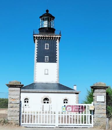
Lighthouses of France: Morbihan

France (officially the French Republic, République française) has coasts facing south on the Mediterranean Sea, west on the open Atlantic Ocean, and north on the English Channel (La Manche in French). Long a leader in lighthouse design, France has scores of famous and historic lighthouses. And it was a French engineer and physicist, Augustin-Jean Fresnel (1788-1837), who invented the powerful and beautiful lenses used in lighthouses around the world.

The old French province of Bretagne (Brittany), now one of the 12 administrative regions (régions) of Mainland France, occupies a peninsula at the northwestern corner of France, separating La Manche from the Bay of Biscay (known in France as the Golfe de Gascogne). Like Wales, Brittany is an ancient Celtic country that maintained its independence until the end of the fifteenth century. Today it is divided into several départements of the French Republic. This page includes lighthouses of the département of Morbihan, which faces south on the Bay of Biscay. Many of these lighthouses are clustered around the Baie de Quiberon, a broad sound partly sheltered by Belle-Île and the peninsula of Quiberon. In the Breton language the waters sheltered by Belle-Île, including the Baie de Quiberon, are called Morbihan, the "small sea."

The French word for a lighthouse, phare, is often reserved for the larger coastal lighthouses; a smaller light or harbor light is called a feu (literally "fire," but here meaning "light") or a balise (beacon). The front light of a range (alignement) is the feu antérieur and the rear light is the feu postérieur. In French île is an island, cap is a cape, pointe is a promontory or point of land, roche is a rock, récife is a reef, baie is a bay, estuaire is an estuary or inlet, détroit is a strait, rivière is a river, and havre is a harbor.

Aids to navigation in France are maintained by the Bureau des Phares et Balises, an agency of the Direction des Affaires Maritimes (Directorate of Maritime Affairs). The Directorate has four regional offices (called Directions Interrégionale de la Mer, or DIRM) at Le Havre, Nantes, Bordeaux, and Marseille. Lights in La Vendée are managed by the DIRM Nord-Atlantique - Manche Ouest at Nantes.

ARLHS numbers are from the ARLHS World List of Lights. FR numbers are the French light list numbers, where known. Admiralty numbers are from volume D of the Admiralty List of Lights & Fog Signals. U.S. NGA List numbers are from Publication 113.

General Sources
DIRM - Phares du Morbihan
Information on the major historic lighthouses.
Les Sentinelles des Mers - France - Bretagne
Photos and information posted by Guy Detienne.
Feux et balises du Morbihan
Additional photos of Morbihan lights posted by Guy Detienne.
Online List of Lights - France - Bay of Biscay
Photos by various photographers posted by Alexander Trabas. Many are by Capt. Peter Mosselberger ("Capt. Peter").
Le Phare à travers le Monde
A large, well known site maintained by Alain Guyomard and Robert Carceller.
Liste des phares du Morbihan
Index to articles in the French language Wikipedia; most include photos. Below the list is an interactive map locating the lighthouses.
Leuchttürme.net - Frankreich - Morbihan
Photos and notes by Malte Werning.
France Lighthouses
Aerial photos posted by Marinas.com.
Lighthouses in Morbihan
Photos by various photographers available from Wikimedia.
Société Nationale pour le Patrimoine des Phares et Balises (S.N.P.B.)
The French national lighthouse preservation organization.
Französische Leuchttürme
Historic photos and postcard images posted by Klaus Huelse.
GPSNauticalCharts
Navigational chart for Morbihan.


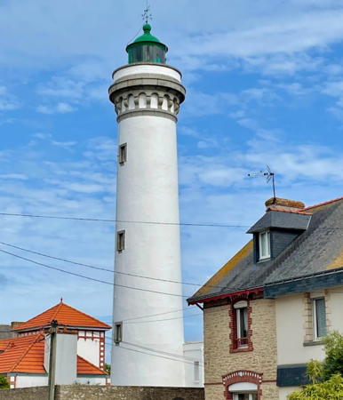
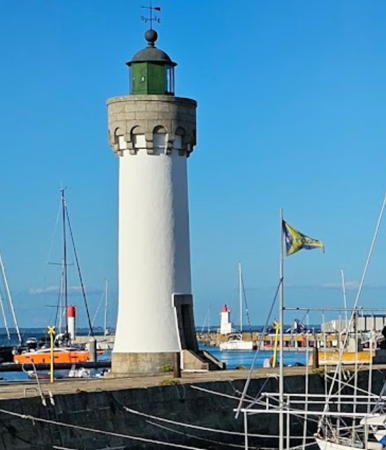
Port Maria Light, Quiberon, July 2023
Google Maps photo by Mauro Regis
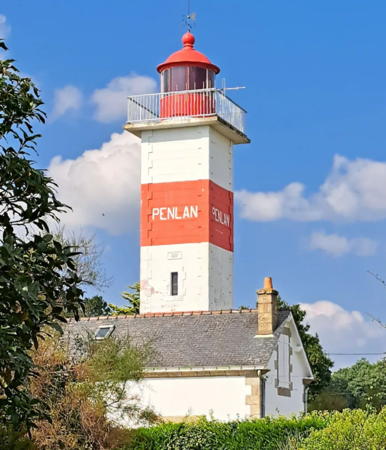

Penlan Light, Billiers, September 2024
Instagram photo by Béa Theaud Becker
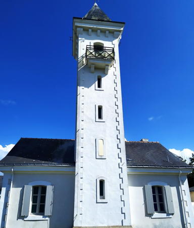
Pénestin Lighthouses
* Pointe du Scal (feu antérieur)
1882. Active; focal plane 8 m (26 ft); quick-flashing green light. 4 m (13 ft) square stone tower with lantern and gallery. The tiny lighthouse is painted white, the lantern green. Werning has a closeup photo, Trabas also has a closeup, a 2018 closeup is available, Detienne has a photo (bottom of the page), and Google has a satellite view. Until 1987 this was the front light of the Tréhiguier range. Located 500 m (0.3 mi) west of the Tréhiguier lighthouse (next entry) on the south side of the Vilaine estuary. Site open, tower closed. ARLHS FRA-602; Admiralty D1066; NGA 0800.
*** Tréhiguier (feu postérieur)
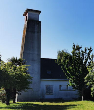
1882. Inactive since 1987. 15 m (49 ft), 5-story square cylindrical stone tower with a pyramidal roof; the light was shown through a window of the top floor. Tower attached to the front of a 1-1/2 story stone keeper's house. A 2021 photo by Stanley Lynch is at right, Werning has a good photo, a 2007 photo is available, Wikipédia's article has Guillaume de Clermont's photo, Detienne has a photo (bottom of the page), and Google has a 2023 street view and a satellite view. The lighthouse was damaged by artillery shelling in December 1944 but was returned to service in 1947. In 1990 the deactivated lighthouse was conveyed to the commune (township) of Pénestin, which has renovated the building as a museum with exhibits on the mussel fishery of the estuary. Located on the Rue du Port in the village of Tréhiguier, on the south side of the Vilaine estuary. Site open, museum open daily in July and August and on the third weekend of the month in the spring and fall; tower status unknown. Owner: Commune de Pénestin; site manager: La Maison de la Mytiliculture. . ARLHS FRA-520; ex-Admiralty D1066.1.

Billiers and Damgan Lighthouses
* Penlan (2)
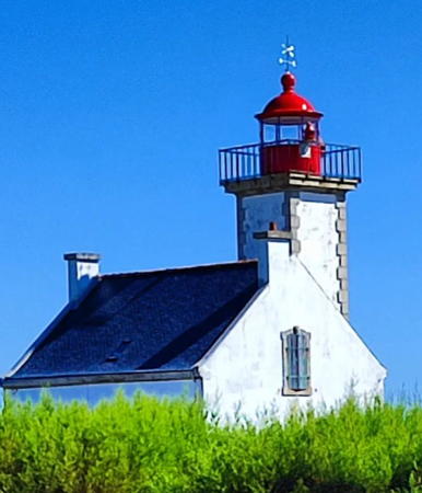
1882 (station established 1839). Active; focal plane 26 m (85 ft); white, red, or green light, depending on direction, occulting twice every 6 s. 18 m (59 ft) square cylindrical masonry tower attached to the front of the original (1840) 2-story keeper's house. Lighthouse painted with red and white horizontal bands; lantern is red. Béa Theaud Becker's 2024 photo is at the top of this page, Werning has a good photo, Detienne has a page for the lighthouse, Trabas has a photo by Arno Siering, Wikipédia's article has a photo by Remi Jouan, and Google has a street view and a satellite view. The lighthouse replaced a shorter tower. It was heavily damaged in World War II but was repaired after the war. In 1975 it was raised in height by 4 m (13 ft); Huelse's historic postcard view shows its original appearance. Located in Billiers, at the tip of the Penlan peninsula, which projects into the north side of the Vilaine estuary. Site open, tower closed. . ARLHS FRA-384; FR-0825; Admiralty D1064; NGA 0792.

Tréhiguier Light, Pénestin, May 2021
Instagram photo by Stanley Lynch
Basse Bertrand
Date unknown. Active; focal plane 6 m (20 ft); white or green light, depending on direction, 2 s on, 2 s off. 14 m (46 ft) round stone tower, upper portion painted green. Trabas has a photo by Stephan Hix and Google has a satellite view. Located on a reef about 1.2 km (3/4 mi) west of the Penlan lighthouse. Accessible only by boat. Site open, tower closed. ARLHS FRA-183; Admiralty D1063; NGA 0788.
Basse de Kervoyal
Date unknown. Active; focal plane 7 m (23 ft); quick-flashing white or red light, depending on direction. 12 m (39 ft) round stone tower, painted black with a yellow band at the top. Trabas has Capt. Peter's photo and Google has a very distant street view and a distant satellite view. NGA misspells the name as Kenoyal. Located about 600 m (0.4 mi) off the Pointe de Kervoyal, marking the north side of the entrance to the Vilaine estuary. Accessible only by boat. Site open, tower closed. ARLHS FRA-733; Admiralty D1062.5; NGA 0794.
Tour des Anglais (Tour de Penerf)
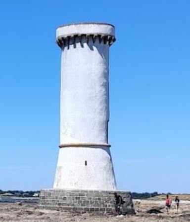
Date unknown; the tower dates from the seventeenth century at least. Inactive. 15 m (49 ft) round unpainted rubblestone tower with a parapet or gallery. Emmanuel Cheyrou-Lagrèze's 2022 photo is at right, Christine Gueveneux has a 2018 photo, Frédéric Fréreux has a closeup photo, Laurent Goulpeau has a 2018 photo, and Google has a satellite view. This was primarily a watchtower but it was also described as a tour à feux ("fire tower") meaning that open fires were lit atop the tower to guide arriving ships. According to French Wikipedia this is believed to be the oldest unmodified tour à feux on the French Atlantic coast. The tower was restored and whitewashed in 1886. Located on a gravel bar on the east side of the entrance to the Penerf estuary. Site open, tower closed.
Le Pignon
Date unknown. Active; focal plane 6 m (20 ft); three flashes every 12 s, white or red depending on direction. 14 m (46 ft) round stone tower, upper portion painted red. Trabas has Capt. Peter's closeup and Google has a satellite view and a very distant street view. Note that there is another Pignon lighthouse near the Îles Chausey in Basse-Normandie. Located on a reef off Penerf on the east side of the entrance to the Rivière de Penerf estuary. Accessible only by boat. Site open, tower closed. ARLHS FRA-585; Admiralty D1062; NGA 0780.

Tour des Anglais, Billiers, August 2022
Google Maps photo by Emmanuel Cheyrou-Lagrèze

Sarzeau and Arzon (Rhuys Peninsula) Lighthouses
* [Saint-Jacques-en-Sarzeau]
Date unknown. Active; focal plane 7 m (23 ft); red light occulting twice every 6 s. 5 m (16 ft) square cylindrical masonry tower with gallery but no lantern. Trabas has Capt. Peter's photo, another photo is available, and Google has a satellite view. Located at the end of the mole in St. Jacques-en-Sarzeau, about 8 km (5 mi) south southwest of Sarzeau on the south side of the Presqu'île de Rhuys. Site open, tower closed. ARLHS FRA-617; Admiralty D1056; NGA 0776.
* Crouesty Jetée du Sud
Date unknown. Active. 6 m (20 ft) square masonry tower with gallery but no lantern. Lighthouse painted white with a narrow green horizontal band; gallery painted green. Trabas has a photo by Stephan Hix and Google has a satellite view and a distant street view. Located on the south jetty at the entrance to Crouesty harbor, on the south side of Arzon. Site open, tower closed. ARLHS FRA-410; Admiralty D1055.6.
* Port Crouesty (feu antérieur)
1982. Active; focal plane about 16 m (52 ft); continuous (?) white light. Approx. 13 m (43 ft) square skeletal tower painted white and carrying a square daymark panel painted red with a white vertical stripe. The tower includes a spiral stairway. Trabas has a photo and Google has a street view and a satellite view. This plain modern lighthouse guides vessels into the port on the south side of Arzon, at the west end of the Rhuys peninsula. Located on a breakwater at the entrance to the marina. Site open, tower closed. Admiralty D1055.
* Port Crouesty (feu postérieur)
1982. Active; focal plane about 33 m (108 ft); quick-flashing white light. 29 m (95 ft) concrete tower, conical at the base but tapering to cylindrical for most of its height. Lighthouse painted white. Trabas has a photo by Stephan Hix, Werning has a good photo, Wikimedia has a photo showing all four Crouesty lights, and Google has a street view and a satellite view. Located on the east side of the harbor. Site open, tower closed. ARLHS FRA-417; Admiralty D1055.1.
* Crouesty Jetée du Nord
Date unknown. Active. 6 m (20 ft) square masonry tower with gallery but no lantern. Lighthouse painted white with a red horizontal band; gallery painted red. Trabas has a photo and Google has a satellite view and a distant street view. Located on the north jetty at the entrance to Crouesty harbor, on the south side of Arzon. Site open, tower closed. ARLHS FRA-662; Admiralty D1055.4.
* Port Navalo (1)
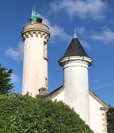
1840. Inactive since 1895. 10 m (33 ft) tower attached to one end of a 2-story keeper's house. The lantern has been replaced by an ordinary conical roof. Building painted white. A 2020 photo of both light towers by Pierre-Yves Vinceneux is at right, Marco Kermabon has a 2022 photo showing both light towers, Guyomard and Carceller have photos and Huelse has a historic postcard view showing both Port Navalo lighthouses. Located on Rue du Phare at the eastern entrance to the Golfe du Morbihan in Arzon. Site and tower closed, but the lighthouse can be seen from the street. ARLHS FRA-434.
* Port Navalo (2)
1895 (station established 1840). Active; focal plane 32 m (105 ft); white, red, or green light, depending on direction, occulting three times every 12 s. 19 m (62 ft) masonry tower with lantern and gallery, attached to the opposite end of the original (1840) keeper's house. Tower painted white; gallery is unpainted stone; lantern painted green. A 2020 photo of both light towers by Pierre-Yves Vinceneux is at right, Detienne has a page for the lighthouse, Heinz Haas has a 2022 photo, Werning has a photo, Trabas has a photo, Guyomard and Carceller have photos, Huelse has a historic postcard view showing both Port Navalo lighthouses, and Google has a street view and a satellite view. Located on Rue du Phare at the eastern entrance to the Golfe du Morbihan in Arzon. Site and tower closed, but the lighthouse can be seen from the street. . ARLHS FRA-435; FR-0820; Admiralty D1054; NGA 0768.

Old and new Port-Navalo Light, Arzon, June 2020
Instagram photo by Pierre-Yves Vinceneux

Saint-Philibert and Trinité-sur-Mer (Crac'h Estuary) Lighthouses
* [Saint-Philibert (Crac'h Entrée Feu Antérieur) (2)]
Date unknown (station established 1856). Active; focal plane 11 m (36 ft); quick-flashing white, red, or green light, depending on direction. 6 m (20 ft) semicircular cylindrical concrete tower with gallery and an enclosed equipment room in the base. Lighthouse painted white, gallery green. The original 1-story stone keeper's cottage stands just behind the light tower. Trabas has a closeup, Werning has a photo, Wikimedia has a photo, Detienne has a photo, Guyomard and Carceller also have a photo, and Google has a good street view and a satellite view. Located on the Avenue Anna le Bail near the point of the Saint-Philibert peninsula, marking the east side of the entrance to the Crac'h estuary. Site open, tower closed. ARLHS FRA-499; Admiralty D1050; NGA 0752.
* Kernevest (Crac'h Entrée Feu Postérieur)
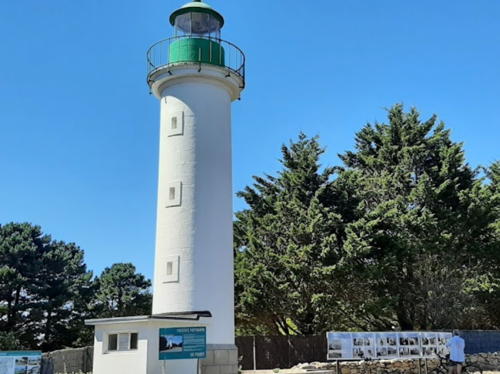
1856. Inactive since 2012. 15 m (49 ft) masonry tower with lantern and gallery. Tower painted white, lantern green. Patricia Serrar's 2022 photo is at right, Timothée Haller has a closeup photo, Werning has a good photo, Detienne has a photo, Guyomard and Carceller have a photo by Alain Collouard, Jacques Hirschi has a 2022 closeup, and Google has a satellite view. A woman, Anna Le Bail, was the keeper from 1925 to 1965. The Commune of Saint-Philibert purchased the lighthouse in 2014 and restored it the following year. The municipality has held several open house opportunities and plans to schedule more during the summer; inquire locally. Located at the intersection of the Rue du Phare and the Rue de l'Étang on the east side of the Crac'h estuary, 560 m (0.35 mi) northwest of the front light. Site open, tower closed. Owner/site manager: Commune of Saint-Philibert. . ARLHS FRA-328; ex-Admiralty D1050.1; ex-NGA 0756.
* [Trinité-sur-Mer]
Date unknown. Active; focal plane 6 m (20 ft); white or red light, depending on direction, occulting twice every 6 s. 6 m (20 ft) square cylindrical cement block tower with gallery and an enclosed equipment room in the base. Lighthouse painted white, gallery red. Trabas has Capt. Peter's closeup photo, Guyomard and Carceller have photos, Wikimedia has Pierre André LeClercq's photo, and Google has a satellite view and a distant street view. Located on the wharf in Trinité-sur-Mer, on the west side of the Crac'h estuary. Site open, tower closed. ARLHS FRA-525; Admiralty D1052; NGA 0764.

Kernevest Light, Saint-Philibert, August 2022
Google Maps photo by Patricia Serrar

Quiberon Lighthouses
Quiberon is a town at the end of a long narrow peninsula pointing south from the Breton coast. In fact, the peninsula is what geologists call a tombolo: it is an island that has become attached to the mainland by a narrow sandbar. Although it was never much of a commercial port, Quiberon is now a popular seaside resort with two large harbors for small craft, Port Haliguen and Port Maria.

*
Port Haliguen (2)
1856 (station established 1842). Inactive, probably since 1970. 12 m (39 ft) masonry tower with lantern and gallery. Tower painted white with unpainted stone trim, lantern painted dark green. Emmanuel Le Proudhom's photo is at right, Werning has a photo, Wikimedia has a photo, Céline Stephan has a 2022 photo, and Google has a street view and a satellite view. The lighthouse was deactivated after the harbor was expanded and reconfigured to be primarily a harbor for pleasure craft; it was replaced by pierhead lights on the breakwaters. Located on the old breakwater at Port Haliguen on the northeast side of Quiberon. Site open, tower closed. ARLHS FRA-422; ex-Admiralty D1026.
* Port Haliguen Old South Breakwater
1970. Active; focal plane 10 m (33 ft); three red flashes every 12 s. 7 m (23 ft) square tower attached to a small equipment cabinet. Tower painted white with a red top. Trabas has Capt. Peter's closeup photo, this light is at the far right in a 2009 photo, and Google has a satellite view. New breakwaters have been built outside the old ones and they are marked with slender round towers. Detienne has a photo of the two new lights and Trabas has Capt. Peter's photo of the new south breakwater light (Admiralty D1026.2; focal plane 10 m (33 ft); two flashes every 6 s, white or red depending on direction). Port Haliguen is a small boat harbor in the lee (that is, to the northeast) of Quiberon. Located at the end of the original south breakwater. Accessible by walking the pier. Site open, tower closed. ARLHS FRA-424; Admiralty D1026; NGA 0736.
* Port Haliguen Old North Breakwater
1970. Inactive. 7 m (23 ft) square tower attached to a small equipment cabinet. Tower painted white with a green top. This light is at the far left in a 2009 photo and Google has a satellite view. Trabas has Capt. Peter's photo of the new north breakwater light (Admiralty D1026.4; two green flashes every 6 s). Located at the end of the original south breakwater. Accessible by walking the pier. Site open, tower closed. ARLHS FRA-423.

Port Haliguen Light, Quiberon, August 2023
Google Maps photo by Emmanuel Le Proudhom
La Teignouse
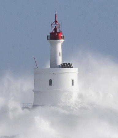
1845. Active; focal plane 20 m (66 ft); flash every 4 s, white or red depending on direction. 20 m (66 ft) cylindrical masonry tower with gallery, rising from the center of a 2-story circular keeper's house. Louis Métivet has the 2020 photo at right, Wikimedia has several photos, Trabas has Capt. Peter's photo, Nathalie Robart has a distant view, Wikipédia has an article, and Google has a satellite view. Built on a small rocky islet, this is one of France's oldest waveswept lighthouses. It guides vessels entering the Baie de Quiberon through the Passage de la Teignouse, the strait between the tip of the peninsula and the Île d'Houat. In 1983 the lighthouse was automated; the lantern was removed and replaced by an aerobeacon powered by a wind turbine. Lighthouse painted white; gallery, beacon, and wind turbine mast painted red. Located on a rock about 6.5 km (3.5 mi) east southeast of Quiberon. Accessible only by boat. Site and tower closed. ARLHS FRA-057; FR-0811; Admiralty D1022; NGA 0692.
* Port Maria (Quiberon)
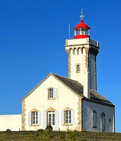
1894. Active; focal plane 28 m (92 ft); quick-flashing light, white, red or green depending on direction. 25 m (82 ft) masonry tower with lantern and gallery, rising from the center of a 1-story keeper's house. Lighthouse painted white with gray trim, lantern green. A 2023 photo by Mauro Regis is at the top of this page, Detienne has a page for the lighthouse, Werning has a good photo, Trabas has a closeup by Arno Siering, Jean-François Gornet has a nice 2009 photo, Wikipédia's article has a photo by Remi Jouan, Jürgen Simon has a 2023 closeup, Marinas.com has aerial photos, Klaus Huelse has a historic postcard view, and Google has a 2023 street view and a satellite view. Port Maria is the traditional harbor of Quiberon. Until 1962 the light was the rear light of a range; a shifting channel left the lighthouse off the range line. Located three blocks from the waterfront on the Rue du Phare in Quiberon. Site open, tower closed. . ARLHS FRA-430; FR-0806; Admiralty D1016; NGA 0672.
* Port Maria Môle Est
Date unknown. Active; focal plane 9 m (30 ft); green light, 2 s on, 2 s off. 7 m (23 ft) round tower with an enclosed equipment room at the base. Lighthouse painted white, lantern green. Trabas has Capt. Peter's closeup photo, Bernard Fontaines has a photo, Alain Boulanger has a photo, Google has a very distant street view of the two mole lights, and Google has an indistinct satellite view. Located at the end of the east mole of the historic harbor of Port Maria, directly in front of the Phare de Port Maria. Site open, tower closed. ARLHS FRA-613; Admiralty D1018; NGA 0688.
Port Maria Jetée du Sud
Date unknown (around 1962?). Active; focal plane 9 m (30 ft); red light occulting twice every 6 s. 5 m (16 ft) round equipment room with the light mounted on the roof. Lighthouse painted white, lantern red. Trabas has Capt. Peter's closeup photo, a 2021 closeup is available, Manel Trenchs i Mola has a street view, and Google has a distant satellite view. Located at the end of the breakwater, which encloses the southwest side of Port Maria's harbor. Accessible by walking the pier. Site open, tower closed. ARLHS FRA-612; Admiralty D1017; NGA 0684.

La Teignouse Light, Quiberon, December 2020
Google Maps photo by Louis Métivet

Île d'Houat and Île d'Hoëdic Lighthouses
Houat and Hoëdic (Hœdic) are small islands located in the Baie de Quiberon east of Pointe de Kerdonis on Belle-Île. Both islands are accessible by ferry from Quiberon. Houat has a population of about 300, and there are barely 100 on Hoëdic.
Grands-Cardinaux
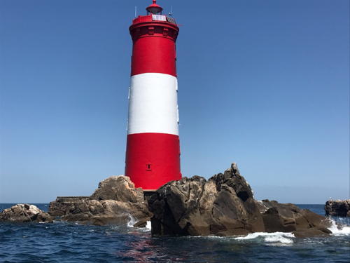
1880. Active; focal plane 28 m (92 ft); four white flashes every 15 s. 27 m (89 ft) stone tower with lantern and gallery, incorporating keeper's quarters. Lighthouse painted red with a broad white horizontal band. A photo is at right, Detienne has a page for the lighthouse, a 2017 photo is available, Michel Matera has a 2022 photo, Wikimedia's distant view by Thomas Basset is also seen in Wikipédia's article, Huelse has a historic postcard view, and Google has a satellite view. This lighthouse guards the southern entrance to the Baie de Quiberon. Originally all white, the tower was painted all black with a white band in 1935 and received in present red and white pattern in 1950. A 2017 photo by R. Franz showed the lighthouse in need of paint. A support group was organized and in 2017-19 the lighthouse was restored and repainted with a rebuilt lantern. Located on a rocky shoal about 4 km (2.5 mi) southeast of Hoëdic. Accessible only by boat. Site and tower closed. ARLHS FRA-017; FR-0816; Admiralty D1086; NGA 0728.
* Hoëdic Jetée
Date unknown. Active; focal plane 10 m (33 ft); flash every 4 s, white or green depending on direction. 7 m (23 ft) semicircular cement block tower with gallery attached to a small equipment room in the base. Lighthouse painted white. Trabas has Capt. Peter's photo, Detienne has a photo, Guyomard and Carceller have a photo, and Google has a satellite view. Located at the end of the west jetty at the harbor of Hoëdic, on the north side of the island. Site open, tower closed. Admiralty D1084; NGA 0724.
* Hoëdic (2)
1857 (station established 1836). Inactive since 1880. Originally a 12 m (39 ft) square cylindrical stone tower with lantern and gallery, attached to a 1-1/2 story stone keeper's house. The lighthouse was deactivated after the Grands-Cardinaux light was established offshore, and the upper portion of the light tower has been removed. However, the keeper's house remained in service as the onshore keeper's station for Grands-Cardinaux, and it survives today as a private residence. Guyomard and Carceller have a photo by Yann Guimond (bottom of the page) and Google has a satellite view. Located at the eastern tip of Hoëdic. Site and house closed (private) but the house can be seen from the road.

Grands-Cardinaux Light, Hoëdic, 2019
contributed photo copyright Phare des Grands Cardinaux; courtesy of Guy Detienne
* [Île d'Houat (Jetée de St. Gildas)]
1957. Active; focal plane 8 m (26 ft); two white or green flashes every 6 s, depending on direction. 5 m (17 ft) masonry tower with gallery; the light is displayed from a short mast. Tower painted white, mast and gallery green. Trabas has Capt. Peter's photo, Wikimedia has Remi Jouan's photo, Detienne has a photo, and Google has an indistinct satellite view. Located at the end of the breakwater mole at the village of Île d'Houat, on the northeast side of the island. Accessible by walking the pier. Site open, tower closed. ARLHS FRA-627; Admiralty D1082; NGA 0720.

Belle-Île-en-Mer Lighthouses
Belle-Île-en-Mer ("Beautiful Island in the Sea"), located about 13 km (8 mi) south of Quiberon, is the largest of the Breton islands, with a length of about 17 km (11 mi) northwest to southeast. The island is accessible by ferry from both Quiberon and Lorient.

****
Goulphar (Grand Phare de Belle-Île)
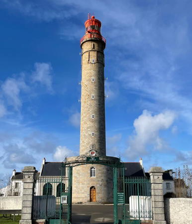
1836. Active; focal plane 87 m (285 ft); two white flashes every 10 s. 52 m (171 ft) granite tower with lantern and gallery, rising from a 2-story circular base attached to a large 1- and 2-story keeper's complex. Vanessa Criton's 2021 photo is at right, Detienne has a page for the lighthouse, Trabas has an excellent photo by Philippe Le Bret, Nicolas Compagnon has a 2007 photo, Wikimedia has many photos including the Remi Jouan photo seen in Wikipédia's article, Loic Maugan has a 2022 closeup, Marinas.com has aerial photos, Huelse has a historic postcard view, and Google has a street view and a satellite view. One of France's most powerful lighthouses, the Phare de Goulphar is designed to have a range of 50 km (31 mi). It is staffed as a control point for many lighthouses on the south side of Brittany, and it also serves as an accommodation for pilots. At the end of World War II, it was discovered that German troops had placed 127 kg (280 lb) of explosives in the tower to blow it up; German POWs were ordered to remove the explosives, and they managed to do so safely. The large keeper's house complex was expanded in 1951-52. Located in the village of Kervilahouen, about 10 km (6 mi) southwest of Le Palais overlooking the open Atlantic. Site open; tower open Wednesday through Sunday mid April through early July, daily in July and August, Wednesday through Sunday in September, and on Wednesday, Friday and Saturday in October, also at certain holiday periods. . ARLHS FRA-301; FR-0799; Admiralty D1032; NGA 0640.

Goulphar Light (Grand Phare de Belle-Île), Bangor, November 2021
Instagram photo by vanessacriton
* Pointe des Poulains
1868. Active; focal plane 34 m (112 ft); white flash every 5 s. 18 m (59 ft) square cylindrical masonry tower with lantern and gallery, rising from the front of a 1-1/2 story stone keeper's house. Building painted white with unpainted stone trim; lantern painted red. The south side of the roof is covered by solar panels. The original 4th order Fresnel lens is on display at the Goulphar Lighthouse Museum. A 2022 photo is at right, Detienne has a page for the lighthouse, Michel Gagneux has a 2022 photo, Trabas has a photo by Darlene Chisholm, Wikipédia has an article with two of Wikimedia's photos, Guyomard and Carceller have photos, Marinas.com has aerial photos, Huelse has a historic postcard view, Nicolas Drouin has a street view, and Google has a satellite view. The lighthouse was converted to solar power in 1999. Located on a small islet just off the northwestern point of Belle-Île. The islet is a nature preserve. The lighthouse is accessible at low tide by a short walk on the access road; parking is limited. Site open, tower closed. according to Detienne the keeper's house is sometimes open for ecological exhibitions. Site manager: Conservatoire du Littoral (Pointe des Poulains). . ARLHS FRA-059; FR-0798; Admiralty D1030; NGA 0644.
* Sauzon
1859. Active; focal plane 9 m (30 ft); quick-flashing green light. 9 m (30 ft) masonry tower with lantern and gallery. Tower painted white, lantern green, gallery rail black. Trabas has a photo by Darlene Chisholm, Wikimedia has many photos including the Remi Jouan photo seen in Wikipédia's article, Breizh Ibis has a nice view, Huelse has a historic postcard view, and Google has a street view and a satellite view. Located on the west side of the harbor of Sauzon, a small port on the northwestern coast of Belle-Île. Site open, tower closed. . ARLHS FRA-469; Admiralty D1044; NGA 0648.
* Le Palais Môle du Nord (2)
1891 (station established 1839). Active; focal plane 8 m (26 ft); quick-flashing green light. 10 m (33 ft) masonry tower with lantern and gallery. Tower painted white, lantern green. Trabas has a good photo by Philippe Le Bret, Guyomard and Carceller also have photos, Wikipédia's article has several photos, Huelse has a historic postcard view, Jeremy Nicola has a street view from the south mole, and Google has a satellite view. Located at the end of the mole enclosing the northwest side of the harbor of Le Palais, the principal town of Belle-Île. Good view from ferries arriving from the mainland. Site open, tower closed. ARLHS FRA-341; Admiralty D1042; NGA 0660.
* Le Palais Môle du Sud
1891. Active; focal plane 8 m (26 ft); quick-flashing red light. 10 m (33 ft) masonry tower with lantern and gallery. Tower painted white, lantern red. Trabas has a good photo by Darlene Chisholm, Guyomard and Carceller also have photos, Wikipédia's article has several photos, Breizh Ibis has a 2022 photo, Jeremy Nicola has a closeup street view, and Google has a satellite view. Located at the end of the mole enclosing the southeast side of the harbor of Le Palais, the principal town of Belle-Île. Good view from ferries arriving from the mainland. Site open, tower closed. ARLHS FRA-342; Admiralty D1040; NGA 0664.

Pointe des Poulains Light, Sauzon,November 2022
Instagram photo by flodavestory
* Pointe de Kerdonis
1879. Active; focal plane 35 m (115 ft); three red flashes every 15 s. 14 m (46 ft) square cylindrical masonry tower with lantern and gallery, rising from the front of a 1-1/2 story stone keeper's house. Building painted white with unpainted stone trim; lantern and gallery painted red. Detienne has a page for the lighthouse, Trabas has a closeup by Philippe Le Bret, a 2017 closeup is available, Huelse has a historic postcard view, and Google has a street view and a satellite view. Located at the easternmost point of Belle-Île, about 5 km (3 mi) northeast of Locmaria. Site open, tower closed. . ARLHS FRA-323; FR-0800; Admiralty D1036; NGA 0668.

Plateau des Birvideaux Lighthouse
Les Birvideaux
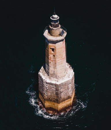
1934. Active; focal plane 24 m (79 ft); two white flashes every 6 s. 29 m (95 ft) octagonal concrete tower with lantern and gallery, incorporating keeper's quarters, mounted on a large concrete base. Lighthouse painted black with a broad red horizontal band below the lantern. Mathieu Esnault's 2020 drone view is at right, Wikipédia has an article with a 2017 photo, Google Maps has a drone view and a closeup by Marc Schaffner, and Trabas has a distant view, but the lighthouse is not shown in Google's satellite view. The lighthouse marks a dangerous rocky shoal. Efforts to mark this hazard began in 1880 and construction of the present lighthouse began in 1905. Including a suspension of work during World War I construction required 29 years, longer than for any other French lighthouse. Located in the open Atlantic about 13 km (8 mi) west of Quiberon and a similar distance north northwest of Belle-Île. Accessible only by boat in often-heavy seas. Site open, tower closed. . ARLHS FRA-199; Admiralty D1014; NGA 0636.

Etel Lighthouse
* [Etel (5)]
Date unknown (station established 1859). Active; focal plane 13 m (43 ft); white, red or green light depending on direction, occulting twice every 6 s. 11 m (36 ft) triangular skeletal mast, painted red. Trabas has a photo, Wikimedia has a photo, Patrick Guérin has a street view, and Google has a satellite view. The first beacon was replaced in 1872 with a cast iron lighthouse; Huelse has a historic postcard view of that light. It was destroyed during World War II and replaced by a temporary wood skeletal tower in 1947. Werning has a photo of the fourth (1951) tower, a square skeletal lighthouse. Located at the end of the Rue du Sémaphore, on the west side of the entarnce to the Etel estuary, about 16 km (10 mi) east of Port-Louis. Site open, tower closed. Admiralty D1012; NGA 0632.

Les Birvideaux Light, July 2020
Instagram photo by Mathieu Esnault

Port-Louis Lighthouses
* Kerbel Feu Postérieur (2) (Phare de Poulfanc)
1857 (station established 1854). Inactive since 1913. 15 m (49 ft) stone tower with stone lantern room and gallery; the light was shown through a small square opening in the lantern room. Lighthouse is unpainted gray stone. A photo by Jean-Robert Bos is at right, Wikipédia's article has a closeup photo, and Google has a street view and a satellite view. The light was found to be not high enough, so the lighthouse was replaced by a new tower in 1913. This little-known lighthouse appears to be in private ownership today. It also appears to be endangered by poor maintenance. Located just off the Route de la Croizetière, about 400 m (1/4 mi) northeast of the newer tower (next entry). Site status unknown, but the lighthouse can be seen from streets nearby; tower closed. Owner/site manager: unknown. ARLHS FRA-443.
** Kerbel Feu Postérieur (3)
1913 (station established 1854). Inactive since 1989. 23 m (75 ft) granite tower, adjacent to a keeper's house. The lantern has been replaced by a round, glass-enclosed observation room. Tower painted white, lantern black. Marie Pastruch has a 2022 photo, Wikipédia's article has a closeup photo, Wikimedia has a view from the bay, and Google has a street view and a satellite view. Originally the lighthouse was similar to the Port Maria lighthouse in Quiberon (see the photo at the top of the page). It is now the centerpiece of a development that includes restaurants and other facilities. The keeper's house has been renovated and is available for accommodations. The lantern is placed next to the swimming pool beside the house. Located at 71 Route de Port-Louis in Riantec, on the east side of Port-Louis. Site and tower open. Owner/site manager: Phare de Kerbel . ARLHS FRA-798.
Les Trois Pierres
1896. Active; focal plane 11 m (36 ft); quick-flashing red or green light, depending on direction. 17 m (56 ft) octagonal solid reinforced concrete tower with gallery and a small lantern; access to the gallery is by an external ladder. Tower painted with black and white horizontal bands. Trabas has Capt. Peter's photo, Hervé Therry posted a photo, Guyomard and Carceller have a photo, Daniel Le Cornec has a 2022 photo, and Google has a satellite view. This light guards an infamous reef in the middle of the entrance to the Rade (roads) de Lorient. Originally only 11 m (36 ft) tall, the tower was increased in height by 6 m (20 ft) in 1913. It was damaged during World War II and quickly repaired after the war. In early July 2002 it was run over by a fishing trawler. Work to restore it began in March 2004 and was completed that year. Located in the entrance to the Rade de Lorient, roughly 1.5 km (1 mi) from either side. Accessible only by boat; there should be good views from Gâvres to the east or Larmor-Plage to the north. Site and tower closed. Admiralty D0974; NGA 0556.

1857 Phare de Poulfanc, Riantec, August 2020
Google Maps photo by Jean-Robert Bos
Les Soeurs (Port-Louis Feu Antérieur)
Date unknown. Active; focal plane 11 m (36 ft); quick-flashing white light, intensified on the range line. 11 m (36 ft) octagonal solid reinforced concrete tower with gallery and a small lantern; access to the gallery is by an external ladder. Tower painted red with a white horizonal band. Trabas has Capt. Peter's photo and Google has a satellite view. This is the front light of the entrance range for Lorient. Located about 500 m (0.3 mi) southwest of the Port-Louis waterfront. Accessible only by boat. Site and tower closed. ARLHS FRA-337; Admiralty D0971; NGA 0565.
* Port-Louis Feu Postérieur
Date unknown. Active; focal plane 22 m (72 ft); quick-flashing white light, intensified on the range line. Approx. 20 m (66 ft) square skeletal tower mounted atop a 2-story building. The tower carries are large daymark colored with red and white horizontal bands. Trabas has a photo and Google has a street view and a satellite view. Located within a walled compound on the Rue de l'Hôpital, 740 m (1/2 mi) northeast of the front light. Site status unknown, but the light can seen from the street. Admiralty D0971.1; NGA 0565.1.

Lorient Lighthouses
Lorient (originally spelled L'Orient) gets its oriental name from the French East India Company, which built its base there in the late 1600s. The city's harbor, the Rade de Lorient, is an estuary fed by several small rivers. Port-Louis is on the east side of the estuary entrance facing Larmor-Plage on the west side; Lorient is upstream from Larmor-Plage on the west side.

Passe de la Citadelle (Île Saint-Michel) Feu Antérieur
Date unknown. Active; focal plane 8 m (26 ft); quick-flashing green light intensified on the range line. 14 m (46 ft) round concrete tower, painted white; gallery rail at the top painted green. Werning has a photo, Trabas has Capt. Peter's photo, and Google has a satellite view. Located off the southwest tip of the Île Saint-Michel in Lorient harbor, opposite the Kéroman district. Accessible only by boat. Admiralty D0978; NGA 0576.
Passe de la Citadelle (Île Saint-Michel) Feu Postérieur
Date unknown. Active; focal plane 14 m (46 ft); quick-flashing green light intensified on the range line. 19 m (62 ft) semicircular cylindrical concrete tower, painted white; gallery rail at the top painted green. Werning has a photo, Trabas has a photo, and Google has a satellite view. Located off the northwest shore of the Île Saint-Michel in Lorient harbor, opposite the Kéroman district. Accessible only by boat. Admiralty D0978.1; NGA 0580.

Larmor-Plage Lighthouses
La Petite Jument
Date unknown. Active; focal plane 5 m (17 ft); red light, 3 s on, 1 s off. 12 m (39 ft) round metal tower, painted red and mounted on a round stone pier. Werning has a photo, Trabas has Capt. Peter's photo, and Google has a satellite view and a distant street view. Located on the west side of the entrance channel to Lorient, just off the citadel of Kernével. There's good view from shore. Accessible only by boat. Site open, tower closed. ARLHS FRA-576; Admiralty D0982; NGA 0592.
* Kernéval Feu Antérieur
1960 (?). Active; focal plane about 10 m (33 ft); quick-flashing red light. 10 m (33 ft) square skeletal tower painted white and carrying a square daymark panel with upper half painted red and lower half white. The tower includes a spiral stairway. Trabas has Capt. Peter's photo and Google has a street view and a satellite view. Located at the foot of the Allée des Châteaux in Kernéval, in Larmor-Plage on the south side of Lorient. Site open, tower closed. Admiralty D0996; NGA 0612.
* Kernével Feu Postérieur (3)
1960 (station established 1877). Active; focal plane 18 m (59 ft); quick-flashing red light, intensified on the range line. 16 m (52 ft) square concrete tower with square concrete lantern room, attached to the front corner of a 1 1/2-story keeper's house. A 2022 photo is at right, Werning has a photo, Trabas has Capt. Peter's photo, another 2022 photo is available, and Google has a good street view and a satellite view. The original lighthouse was destroyed in 1944. A temporary light was erected in 1950 and served until the present lighthouse was built. This is the rear light of a downstream range that guides ships outbound from the Rade de Pen-Mané, the main harbor of Lorient. Located on the Rue du Petite Phare in Kernéval, Site open, tower closed. ARLHS FRA-327; Admiralty D0996.1; NGA 0616.

Feu Postérieur, Kernéval, June 2022
Google Maps photo by gesla 26.11.

Île de Groix Lighthouses
The Île de Groix is about 5 km (3 mi) long and 3 km (2 mi) wide, oriented from east to west, and lying about 3 km (2 mi) from the mainland southwest of Lorient. The island is accessible by ferry from Lorient and is a popular tourist destination.
* Port Tudy Môle du Nord
1893. Active; focal plane 12 m (39 ft); green light, 2 s on, 2 s off. 10 m (33 ft) cylindrical masonry tower with lantern and gallery. Tower painted white, lantern and gallery green. Trabas has Capt. Peter's photo, Daniel Le Cornec has a 2019 photo, Clara Grillière has a photo, Jean-Baptiste Richard has a photo of both Port Tudy lighthouses, Serge Heurteur has a distant street view, and Google has a satellite view. Located at the end of the north breakwater enclosing the harbor of Port Tudy, on the north side of the island. Accessible by walking the mole; there are also excellent views from ferries arriving from Lorient. Site open, tower closed. ARLHS FRA-437; Admiralty D0966; NGA 0540.
* Port Tudy Môle de l'Est
1893. Active; focal plane 11 m (36 ft); green light, 2 s on, 2 s off. 10 m (33 ft) cylindrical masonry tower with lantern and gallery. Tower painted white with one narrow red horizontal band near the base, lantern and gallery red. Trabas has Capt. Peter's photo, Eric Prévotat has a 2021 photo, Peter Falk has a photo, Jean-Baptiste Richard has a photo of both Port Tudy lighthouses, Serge Heurteur has a street view, and Google has a satellite view. Located at the end of the east breakwater enclosing the harbor of Port Tudy, on the north side of the island. Accessible by walking the mole; there are also excellent views from ferries arriving from Lorient. Site open, tower closed. ARLHS FRA-436; Admiralty D0964; NGA 0536.
* Pointe de la Croix (Pointe de Surville) (3)
1898 (station established 1830). Active; focal plane 16 m (52 ft); white or red light, depending on direction, occulting once every 4 s. 4 m (14 ft) cast iron lantern, painted red, mounted on a concrete base. Wikimedia has Sylvain Machefert's photo, Hervé Therry posted a closeup photo, Guyomard and Carceller have a photo by Valentine Verdet of the lantern perched on the bluff above the beach, Trabas has Capt. Peter's photo, and Google has a satellite view. Sometimes claimed to be France's smallest lighthouse. This light was initally established within the walls of the historic Fort de Surville, one of the fortifications guarding the approach to Lorient. Two taller lighthouses, built in 1830 and 1845, had to be removed because they came into the line of fire of the fort's artillery. Finally the light was removed from the fort to eliminate this problem. Located at the eastern point of the island. Site open, tower closed. ARLHS FRA-253; Admiralty D0968; NGA 0544.
* Pointe des Chats
1898. Active; focal plane 16 m (52 ft); red flash every 5 s. 15 m (49 ft) square cylindrical tower with lantern and gallery, rising from the front of a 2-story keeper's house. Building painted white with unpainted stone trim; lantern painted red. A 2023 photo is at right, Detienne has a page for the lighthouse, Trabas has a good closeup by Klaus Potschien, Benoit Royer has a 2008 photo, another photo is available, Wikipédia's article has Bruno Corpet's view from the sea, and Google has a satellite view. The lantern was removed for restoration in October 2022. Located at the southeastern point of the island, about 2 km (1.2 mi) southeast of the village of Locmaria. Site open, tower closed. Site manager: Conservatoire du Littoral. . ARLHS FRA-238; FR-0766; Admiralty D0970; NGA 0548.

Pointe des Chats Light, Île de Groix, August 2023
Instagram photo by Claire M.
* Pen-Men
1839. Active; focal plane 60 m (197 ft); four white flashes every 25 s. 28 m (92 ft) square masonry tower with lantern and gallery, rising from a 1-story keeper's house. Lantern and upper half of tower painted black with unpainted stone trim; lower half of tower and keeper's house painted white with unpainted stone trim. The 2022 photo at right shows the results of recent restoration work, Detienne has a page for the lighthouse, Trabas has a fine closeup by Klaus Potschien,Wikipédia's article has two of Wikimedia's many photos, Huelse has a historic postcard view, Olivier Wavre has a distant street view, and Google has a satellite view. The original keeper's house was square with the tower in the center; subsequently the house was considerably enlarged with an addition on the seaward side. The station is staffed. Located in a nature reserve at the west end of the island. Site open, tower reported open for certain holidays and special events but we have no information on the schedule. . ARLHS FRA-387; FR-0762; Admiralty D0962; NGA 0532.

Ploemeur Lighthouses
* Lomener
Date unknown. Active; focal plane 13 m (43 ft); quick-flashing light, white, red, or green depending on direction. 9 m (30 ft) barbell-shaped tower, painted white with a red horizontal band at the top. No lantern. Trabas has a closeup photo by Capt. Peter, Daniel Le Cornec has a 2020 view from the sea, and Google has a street view and an indistinct satellite view. Located on the waterfront on the east side of Lomener, a fishing port about 12 km (7.5 mi) southwest of Lorient. Site open, tower closed. ARLHS FRA-592; Admiralty D0961; NGA 0526.
* Kerroch
Date unknown. Active; focal plane 22 m (72 ft); white, red, or green light, depending on direction, occulting twice every 6 s. 8 m (26 ft) semicircular concrete tower, rising from a square 1-story stone equipment room. No lantern. Tower painted white with a red top; the equipment room is unpainted stone. Trabas has a photo by Heike and Friedrich Klett, Daniel Le Cornec has a photo, a closeup is available, and Google has a satellite view and a distant street view. Located on a promontory at Kerroch, about 15 km (9 mi) southwest of Lorient. Site open, tower closed. ARLHS FRA-569; Admiralty D0960; NGA 0528.

Pen-Men Light, Île de Groix, August 2022
Google Maps photo by rv2c

Information available on lost lighthouses:

Notable faux lighthouses:

Adjoining pages: North: Southern Finistère | South: Loire-Atlantique

Return to the Lighthouse Directory index | Ratings key

Posted October 4, 2005. Checked and revised October 29, 2024. Lighthouses: 47. Site copyright 2024 Russ Rowlett and the University of North Carolina at Chapel Hill.