Lighthouses of Croatia: Northern Dalmatia

The Republic of Croatia (Republika Hrvatska in Croatian) is located on the east side of the Adriatic Sea and includes most of the coastline of the former Yugoslav federation. Including the historic provinces of Istria and Dalmatia, this coastal region has a very long history. In recent times it was part of the Austrian Empire for several centuries until that empire was dissolved in 1918, at the end of World War I. Most of the Croatian coast then became part of Yugoslavia, but the peninsula of Istria, in the northwestern corner, was annexed by Italy. After the end of World War II in 1945 the northwestern corner of Istria was part of the UN-administered Free Territory of Trieste until 1954, when the entire peninsula was reunited with Yugoslavia (the city of Trieste remained in Italy). Croatia became independent in 1991 when the Yugoslav federation fell apart.

The country is divided into 21 counties, 7 of which touch the coast. The principal ports are Rijeka in the north, Split on the central coast, and Dubrovnik in the far south. The histiric region of Dalmatia includes rouhly 3/4 of the Coatian coastline. This page covers the northern third of the Dalmatian coastline, including the Zadar and Šibenik regions.

The Croatian word for a lighthouse is svjetionik. The word rt is a cape or promontory, otok is an island, otočić is an islet, hrid (plural hridi) is a rock, plićak or pličina is a shoal, zaljev is a bay, rijeka is a river, and luka is a port or harbor.

Many places in this area were better known in the past by their Italian names. The Italian names of lighthouses, when known, are shown in curved brackets {}.

Aids to navigation in Croatia are managed by Plovput, a state-owned corporation. Plovput has developed fourteen of the light stations for vacation rental.

ARLHS numbers are from the ARLHS World List of Lights. PS numbers are the numbers, if known, from the Croatian light list Popis Svjetala i Signala za Maglu. Admiralty numbers are from volume E of the Admiralty List of Lights & Fog Signals. U.S. NGA List numbers are from Publication 113.

General Sources
Plovput - Aids to Navigation - Lighthouses
Information and photos posted by Plovput. There is also an Other Aids to Navigation page with photos of typical smaller beacons.
Online List of Lights - Croatia - West Coast
Photos by various photographers posted by Alexander Trabas.
World of Lighthouses - Croatia
Photos by various photographers available from Lightphotos.net.
Lighthouses in Croatia
Aerial photos posted by Marinas.com.
Leuchttürme an der kroatischen Küste
Photos by Olaf Riesenberg posted by Bernd Claußen.
Lighthouses in Croatia
Photos by various photographers available from Wikimedia.
Weitere europäische Leuchttürme auf historischen Postkarten
Historic postcard views posted by Klaus Huelse.
GPSNavigationCharts
Navigation chart information for Croatia.
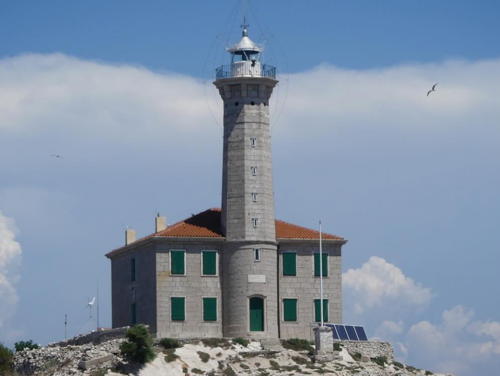

Blitvenica Light, Adriatic Sea, July 2024
Instagram photo by Linda Hammarberg
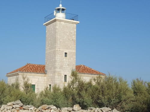

Tri Sestrice (Three Sisters) Light, Rivanj, August 2017
Google Maps photo by
Šibenik-Knin County Lighthouses

Adriatic Sea Lighthouses
Mulo (Hrid Mulo)
1873. Active; focal plane 23 m (75 ft); white flash every 5 s. 18 m (59 ft) octagonal stone tower with lantern and gallery, attached to a 2-story stone keeper's house. The original lantern was removed; it has been replaced recently by a modern open lantern. The lighthouse is unpainted stone. A 2021 photo is available, Małgorzata Matras has a 2023 photo, Dusan Gorencic has a 2017 photo, Marinas.com has aerial photos, Trabas has a distant view, and Google has a satellite view and a closeup street view. This lighthouse helps guide ships around a substantial bulge in the coastline of the mainland. Located on a tiny island about 5 km (3 mi) southwest of Rogoznica. Accessible only by boat. Site open, tower closed. . ARLHS CRO-006; PS-515; Admiralty E3286; NGA 13324.
Blitvenica (Hrid Blitvenica) {Isolotto Lucietta)
1872. Active; focal plane 38 m (125 ft); two white flashes every 30 s. 21 m (69 ft) octagonal stone tower with lantern and gallery, attached to a 2-story stone keeper's house. The lighthouse is unpainted stone; lantern painted white. Linda Hammarberg's 2024 photo is above, Danko Kovac has a 2017 photo, Marko Tezac has a view from the sea, Trabas has Tom Chisholms's 2019 photo, Marinas.com has aerial photos, and Google has a satellite view. The lighthouse is automated but in 2002 Plovput decided to return staff to the station for security and maintenance. This is one of several very isolated Croatian light stations in the Adriatic Sea; landing on the island is very difficult except in the best weather. Located on a tiny island about 7 km (4.5 mi) southwest of the larger island of Žirje and about 30 km (18 mi) southwest of Šibenik. Accessible only by boat. Site open, tower closed. . ARLHS CRO-002; PS-367; Admiralty E3226; NGA 13304.

Šibenik Area (Mainland) Lighthouses
Šibenik (Sibenico in Italian) is a city of about 45,000 residents at the mouth of the Krka River.
* Rt Kremik
1899. Active; focal plane 10 m (33 ft); white flash every 3 s. 8 m (26 ft) octagonal stone tower, painted white. Trabas has a good drone view, Jakub Andert has a 2022 photo, Ladislav Litt has a closeup street view, and Google has a satellite view. Located at the tip of a headland on the south side of the entrance to the bay of Primošten. Site open, tower closed. ARLHS CRO-075; PS-509; Admiralty E3282; NGA 13316.
Otočić Ravan {Isolotto Duinka}
Date unknown (station established 1895). Active; focal plane 12 m (39 ft); white flash every 5 s. 10 m (33 ft) square stone column mounted on a square stone base. Trabas has a photo by Darlene Chisholm and Google has a satellite view. Located on a small island off the southeastern tip of Otok Kaprije. Accessible only by boat. Site open, tower closed. ARLHS CRO-127; Admiralty E3229.2; NGA 13296.
* Rt Jadrija (Šibenik) {Sibenico}
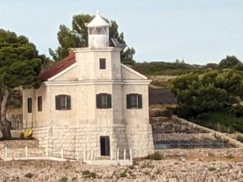
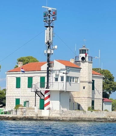
1874. Active; focal plane 11 m (36 ft); two red flashes every 6 s. 12 m (39 ft) octagonal stone tower with lantern and gallery, attached to the seaward side of a 2-story keeper's house (now used as a signal station). Lighthouse painted white. A 2023 photo is at right, Trabas has an excellent photo by Tom Chisholm, Miroslav Koláček has a photo, and Google has a satellite view. Similar to the case of the Prišnjak light (seen below), the focal plane was formerly 7.5 m (25 ft), so the light may have been shown originally from a window of the house. Currently the light is mounted on the gallery rail. This lighthouse marks the entrance to the Kanal Sveti Ante, a narrow channel leading to the port of Šibenik; the mast next to the building carries red and green traffic control lights. Located on the north side of the entrance at Jadrija, about 4 km (2.5 mi) southeast of Srima. Site open, tower closed. ARLHS CRO-058; PS-481; Admiralty E3248; NGA 13184.

Otok Murter Area Lighthouses

Murter is an island about 10 km (6 mi) long, separated from the mainland by a very narrow channel at Tisno. It has several villages and a permanent population of about 5000.

Otočić Maslinjak
1913. Active; focal plane 17 m (56 ft); green flash every 3 s. 7 m (23 ft) round strongly conical tower, painted green. Leon Kljajić has a 2021 view from the sea, Trabas has a distant view and Google has a distant satellite view. Located on the southwestern side of Maslinjak, an island about 2.5 km (1.5 mi) east of the southeastern tip of Otok Murter. Accessible only by boat. Site open, tower closed. ARLHS CRO-095; PS-452; Admiralty E3220; NGA 13120.

Rt Jadrija Light, Jadrija, September 2023
Google Maps photo by Marut T
Kukuljari (1) {Isole Kuljar}
1895. Inactive. Approx. 5 m (17 ft) round stone tower; lantern removed. Active light on a 12 m (39 ft) white metal post, focal plane 11 m (36 ft); white flash every 5 s. Süli Andor has a closeup photo, Trabas has a photo, Jere Radačić has another photo, and Google has a satellite view. This area is very popular with scuba divers. Located on a tiny islet off the southern coast of Murter. Accessible only by boat. Site open, tower closed. ARLHS CRO-218. Active light: Admiralty E3224; NGA 13128.
Prišnjak
1886. Active; focal plane 19 m (62 ft); three white flashes every 10 s. 15 m (49 ft) octagonal stone tower with lantern and gallery, attached to the seaward end of a 1-story stone keeper's house. Lighthouse painted white; the house has a red tile roof. A 2023 photo is at right, Trabas has a closeup photo, another 2023 photo and another nice closeup photo are available, Marinas.com has aerial photos, and Google has a satellite view. Light lists as late as 1920 say the light was shown from a window of the keeper's house, so the light tower must have been added later. Located on a small island off the northwest end of the much larger island of Murter. Accessible only by boat. Site open, tower closed. . ARLHS CRO-121; PS-446; Admiralty E3202; NGA 13076.
Rt Rat (2)
Date unknown (station established 1909). Active; focal plane 10 m (33 ft); white flash every 5 s. 9 m (30 ft) octagonal cylindrical masonry tower with gallery, painted white. The tower has a slight but noticeable lean. Trabas has a photo, Mile Bizic has a closeup street view, and Google has a satellite view. This light marks the northern entrance to the Murterski Channel. Located on a promontory of the mainland opposite the northwestern corner of Otok Murter, about 4 km (2.5 mi) northwest of Tisno. Site open, tower closed. ARLHS CRO-125; Admiralty E3212; NGA 13096.

Prišnjak Light, Murter, August 2023
Google Maps photo by Andreas R.

Kornati Area Lighthouses
Hrid Galijolica
Date unknown. Active; focal plane 11 m (36 ft); two red flashes every 10 s. 8 m (26 ft) square cylindrical stone tower mounted on a square pier. Trabas has a distant view and Google has a satellite view. Located on a reef about 3 km (2 mi) south of Otok Pašman and a similar distance east of Otok Šćine. Accessible only by boat. Site open, tower closed. ARLHS CRO-047; Admiralty E3116.4; NGA 12944.
Otok Smokvica Vela
Date unknown. Active; focal plane 13 m (43 ft); red flash every 3 s. 8 m (26 ft) square tower, painted white. Trabas has Darlene Chisholm's closeup photo and Google has a satellite view. Located on a small island near the southwestern end of the Kornati archipelago, about 15 km (9 mi) southwest of Otok Murter. Accessible only by boat. Site open, tower closed. ARLHS CRO-143; PS-369; Admiralty E3225; NGA 13136.

Zadar County Lighthouses

Zadar Area Lighthouses
Zadar is a historic port city and the seat of Zadar County; it has a population of about 75,000. Under Austrian rule (1815-1918) Zadar was the capital of the Kingdom of Dalmatia.

Otočić Babac
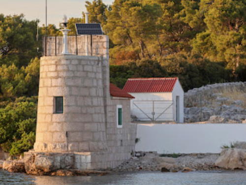
1874. Active; focal plane 7 m (23 ft); two white flashes every 5 s. 6 m (20 ft) round unpainted white stone tower attached to a small stone equipment shelter. The historic keeper's house is nearby; the resident keeper maintains lights throughout the Pašmanski Channel between Pašman island and the mainland. Milan Mikšík's 2022 photo is at right, Luka Grbešić has a photo, Trabas has a closeup photo, Milan Mikšík hs a 2022 photo, Marinas.com has aerial photos and Google has a satellite view. Located on the west point of Babac island, marking a narrow passage in the Pašmanski Channel. Accessible only by boat. Site and tower closed. PS-425; Admiralty E3180; NGA 13032.
* Istarske Obala {Porto Zara}
1880. Active; focal plane 6 m (20 ft); green flash every 2 s. 6 m (20 ft) round cylindrical stone tower with a metal dome; the light is mounted atop the dome. Tower painted with green and white horizontal bands, dome green. Trabas has Tom Chisholm's photo and Google has a street view and a satellite view. This lighthouse is identical to the Zadar Breakwater light (next entry). Located at the end of the peninsula sheltering Zadar's inner harbor, marking the west side of the entrance. Site open, tower closed. PS-396; Admiralty E3148; NGA 13000.

Otočić Babac Light, Zadar, August 2022
Plovput photo by Milan Mikšík
* Zadar Breakwater {Zara Molo}
Date unknown (station established 1853). Active; focal plane 6 m (20 ft); red flash every 3 s. 6 m (20 ft) round cylindrical stone tower with a metal dome; the light is mounted atop the dome. Tower painted white with red and white horizontal bands, dome red. Trabas has Eckhard Meyer's photo, Wikimedia has a photo, William Lee has a 2022 photo, Alex Mitchell has a view of the light and the breakwater, Roman Seidl has a street view, and Google has a satellite view. Located at the end of the breakwater enclosing Zadar's inner harbor. Accessible by walking the breakwater. Site open, tower closed. PS-395; Admiralty E3144; NGA 12996.
* Oštri Rat (Zadar) (2?) {Punta Amica}
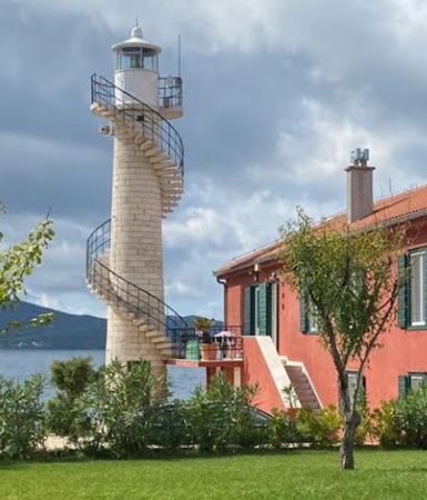
Date unknown (station established 1869). Active; focal plane 14 m (46 ft); three white flashes every 10 s. 14 m (46 ft) round stone tower with lantern and gallery; access to the gallery is by a stairway that spirals around the tower. The tower is unpainted white stone; lantern painted white. Karl-Heinz Zehren's photo is at right, Trabas has a good photo by Arno Siering, Chiara Pesarin has a 2018 photo, and Google has a satellite view. The earlier light was on a cast iron tower. Located on a promontory about 1.5 km (1 mi) northwest of the harbor of Zadar. Site open, tower closed. . ARLHS CRO-109; PS-394; Admiralty E3142; NGA 12992.
Tri Sestrice Rivanj {Tre Sorelle}
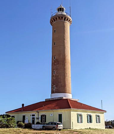
1899. Active; focal plane 16 m (52 ft); two flashes every 5 s, white or red depending on direction. 16 m (52 ft) square cylindrical masonry tower with lantern and gallery, attached to the landward side of a 1-story masonry keeper's house. The building is unpainted stone; lantern painted white. Jadran Goja's 2017 photo is at the top of this page, Trabas has a photo by Hans de Graaf, another good photo is available, Marinas.com has aerial photos, and Google has a satellite view. This is one of three Tri Sestrice ("three sisters") lighthouses in Croatia. Located on a small island (one of three) off the northwest tip of Otok Rivanj, about 16 km (10 mi) northwest of Zadar. Accessible only by boat. Site status unknown. ARLHS CRO-199; PS-370; Admiralty E3106; NGA 12908.

Otok Pag and Otok Vir Area Lighthouses
Rt Tanka Nožica (Rt Debela Nozica)
Date unknown. Active; focal plane 8 m (26 ft); white flash every 3 s. 6 m (20 ft) square pyramidal stone tower atop a square 1-story stone equipment shelter. The building is unpainted stone; the short light post is painted white. Trabas has a photo and Google has a very distant street view, but the small tower is inconspicuous in Google's satellite view. Located on a promontory of the mainland marking the northern entrance to the narrow channel between the mainland and the island of Pag, about 2 km (1.2 mi) northwest of Miletici. May be accessible only by boat. Site open, tower closed. PS-341; Admiralty E2961; NGA 12724.


Oštri Rat Light, Zadar, September 2021
Google Maps photo by Karl-Heinz Zehren

Otočić Mišjak
Date unknown. Active; focal plane 8 m (26 ft); green flash every 3 s. 8 m (26 ft) square pyramidal concrete tower with gallery, mounted on a square stone base. The tower is unpainted; gallery painted green. Trabas has Hans de Graaf's photo and Google has a satellite view. Located off the northwestern tip of Otočić Mišjak, marking a sharp turn in the zigzagging channel between the mainland and Otok Pag. Accessible only by boat. Site open, tower closed. Admiralty E3086; NGA 12684.
* Vir (Otok Vir) {Puntadura}
1881. Active; focal plane 21 m (69 ft); white flash every 10 s. 21 m (69 ft) octagonal cylindrical stone tower with lantern and gallery, attached to a 1-story masonry keeper's house. Entire lighthouse painted white. Dario Šalin's 2024 photo is at right, Trabas has a photo by Eckhard Meyer, Balázs Kucsera has a 2018 photo, Arno Siering contributed a photo, Tibor Szudar has another photo, and Google has a satellite view. The lighthouse has been leased and is available for overnight accommodations. Located on the southwest side of the island of Vir, about 5 km (3 mi) west of the town of Vir. The island is accessible by bridge. Site open, tower closed. Site manager: Villa Lanterna . ARLHS CRO-188; PS-333; Admiralty E3081; NGA 12824.
#Morovnik (1)
Date unknown. Collapsed or demolished. Approx. 16 m (52 ft) octagonal stone tower attached to a 2-story stone keeper's house. The lighthouse is unpainted; lantern painted white. Roberto Gotti has a closeup 2017 photo and a distant view, but the building is missing in Google's satellite view. Located on a small island about 3 km (2 mi) northwest of Olib. Accessible only by boat. Site open, tower closed.
[Morovnik (2)]
Date unknown (1930s?). Active; focal plane 8 m (26 ft); green flash every 5 s. 8 m (26 ft) square cylindrical stone tower with gallery; no lantern. The lighthouse is unpainted light gray stone. Trabas has Uli Knapp's photo and Google has a satellite view. Located on the northwest side of the island. Accessible only by boat. Site open, tower closed. ARLHS CRO-098; Admiralty E3064; NGA 12808.

Vir Light, Vir, August 2024
Google Maps photo by Dario Šalin

Outer Adriatic Island Lighthouses
These lighthouses are at the outermost edge of the Dalmatian islands, facing the open Adriatic Sea.

Sestrice (Sestrica Vela, Tajer) {Porto Tajer}
1876. Active; focal plane 47 m (154 ft); white flash every 8 s. 26 m (85 ft) cast iron tower with lantern, gallery, and eight supporting struts, mounted on a stone base in front of a 2-story masonry keeper's house. Tower painted with red and white spiral stripes; lantern painted white. Staffed weather station. Trabas has Hans de Graaf's photo, Tadej Tuma has a good closeup photo, a 2021 photo is available, Marinas.com also has aerial photos, and Google has a satellite view of the station. We do not know the history of this historic lighthouse; it appears to be of French design. Located on a small island off the southeastern end of Dugi Otok, marking the start of the twisting channel around the end of the island. Accessible only by boat. Site open, tower closed. . ARLHS CRO-015; PS-366; Admiralty E3134; NGA 12872.
* Veli Rat {Punta Bianca}
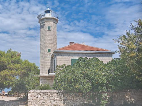
1849. Active; focal plane 41 m (134 ft); two white flashes every 20 s. 36 m (118 ft) round stone tower rising from a 1-story stone keeper's house. The lighthouse is unpainted buff-colored stone; lantern painted white. Miroslav Strašil's 2024 photo is at right, Trabas has a photo by Hans de Graaf, Filippo Giunchedi has a 2007 photo, Marinas.com has aerial photos, and Google has a street view from the beach and a good satellite view. The keeper's house has two apartments available for vacation rental. The lighthouse marks the northwestern end of Dugi Otok ("Long Island"), which extends for 45 km (28 mi) along the Adriatic coast of Zadarska County. The island is accessible by ferry from Zadar. Located about 3 km (2 mi) west of the village of Veli Rat. Accessible by road. Site open, tower open to paying guests. . ARLHS CRO-183; PS-365; Admiralty E3098; NGA 12864.
Rt Bonaster
Date unknown. Active; focal plane 12 m (39 ft); white flash every 2 s. 6 m (20 ft) square pyramidal stone tower atop a square 1-story stone equipment shelter. The building is unpainted stone; the short light post is painted white. Trabas has Uli Knapp's photo and Google has a distant satellite view. Located on the southern tip of Otok Molat. Site open, tower closed. PS-357; Admiralty E3093; NGA 12836.
Rt Vranač {Melada}
1895. Active; focal plane 13 m (43 ft); white flash every 2 s. 8 m (26 ft) round strongly conical metal tower, painted white. Trabas has a photo by Uli Knapp, Augusto Bernasconi has a photo, and Google has a satellite view. Located on the northern tip of Otok Molat, guiding vessels to the harbor of Ist. Site open, tower closed. ARLHS CRO-195; Admiralty E3092; NGA 12832.

Veli Rat Light, Otok, June 2024
Instagram photo
by Miroslav Strašil
Grujica (Otočić Grujica) {Gruizza}
1872. Active; focal plane 17 m (56 ft); three white flashes every 15 s. 15 m (49 ft) square cylindrical masonry tower with lantern and gallery, rising from a 1-story masonry keeper's house. Entire lighthouse is white. Boathouse and other light station buildings. Franziska Sobottka's 2023 photo is at right, Lojze Vrenčur has a photo, Trabas has a closeup photo by Werner Seiler, Andreas Kallhovd has a 2023 drone view, and Google has a satellite view. Located on a small island in the channel between Ilovik and Premuda, about 12 km (7.5 mi) southeast of Veli Lošinj. Accessible only by boat. Site and tower closed. ARLHS CRO-005; PS-266; Admiralty E3044; NGA 12772.

Information available on lost lighthouses:

Notable faux lighthouses:


Grujica Light, Premuda, July 2023
Google Maps photo by Franziska Sobottka

Adjoining pages: North: Primorje Region | South: Central Dalmatia

Return to the Lighthouse Directory index | Ratings key

Posted October 9, 2006. Checked and revised January 16, 2025. Lighthouses: 25. Site copyright 2025 Russ Rowlett and the University of North Carolina at Chapel Hill.