Lighthouses of Indonesia: Eastern Aceh, Sumatra

Indonesia is a huge country of Southeast Asia, stretching along both sides of the Equator for more than 46 degrees of longitude (roughly 5100 km or 3200 miles). It occupies 17,504 islands, by official count, including more than 6000 inhabited islands. It is the world's fourth most populous nation with a population currently estinated at about 280 million. More than half of the population lives on the island of Java. Other major islands include Sumatra in the west, Borneo (shared with Malaysia and Brunei) in the northwest, Sulawesi in the northeast, and the eastern half of New Guinea in the far east. Other well known islands include Bali, Lombok, Sumbawa, Flores, and Timor (shared with independent East Timor) along the south side of the country.

The unification of the country was accomplished over many years of struggle by Dutch colonial authorities. The Dutch East India Company was founded in 1602 to establish and extend Dutch administration, and after the company folded the Netherlands established the Dutch East Indies colony and gradually extended its boundaries to reach the present boundaries of Indonesia. During World War II Japan occupied the islands from March 1942 to the end of the war in 1945. The Republic of Indonesia proclaimed its independence immediately after the war ended and following some conflict the Netherlands accepted the country's independnece in 1949.

Sumatra (Sumatera in Indonesian) is the world's sixth largest island and the westernmost of the major islands of Indonesia. It is separated from Malaysia to the north by the Malacca Strait, from Kalimantan (Borneo) to the northeast by the broad Karimata Strait, and from Java to the southeast by the Sunda Strait. Its south coast faces the open Indian Ocean. The population of Sumatra is about 60 million.

Located at the northwestern end of Sumatra, Aceh (pronounced AH-chay in English) was a powerful independent sultanate for more than three centuries before bring brought, more or less, under Dutch control in the early 20th century. It has been the scene of a lengthy and sometimes violent separatist movement, first against Dutch control and then against Indonesian administration. Following the disastrous tsunami of 26 December 2004 a peace agreement was negotiated with the help of Finnish diplomats and signed in August 2005.

Indonesia is divided into 38 provinces (provinsi) and the provinces are subdivided into county units called regencies (kabupaten). Aceh is a province of Indonesia but under the peace agreement it is governed as a special territory (daerah istimewa) enjoying a considerable degree of autonomy. The capital is Banda Aceh and the territory has a population of roughly four million. This page includes lighthouses of the eastern half of the territory, facing the Andaman Sea to the north and the Strait of Malacca to the east. There's another page for Western Aceh.

More than 700 languages are spoken in Indonesia. The official national language, Indonesian (Bahasa Indonesia), was standardized from a form of Malay that served as a lingua franca across the archipelago. In Indonesian a lighthouse is a mercusuar or a menara suar. Tanjung is a cape, ujung is a headland or point of land, bukit is a hill, sungai is a river, kuala or muara is an estuary or river mouth, pulau is an island, karang is a reef, batu is a rock, laut is a sea, selat is a strait, teluk is a bay, pelabuhan is a harbor, and labuhan is a port.

Aids to navigation in Indonesia are operated and maintained by the Directorate of Marine Navigation within the Directorate General of Sea Transportation.

ARLHS numbers are from the ARLHS World List of Lights. Admiralty numbers are from volume F of the Admiralty List of Lights & Fog Signals. U.S. NGA List numbers are from Publication 112.

General Sources
Lighthouses in Indonesia
Photos by various photographers available from Wikimedia; most of the photos are historic.
World of Lighthouses - Indonesia
Photos by various photographers available from Lightphotos.net.
Online List of Lights - Indonesia
Photos by various photographers posted by Alexander Trabas.
GPSNavigationCharts
Navigation chart information for Aceh.
Navionics Charts
Navigation chart for Aceh.


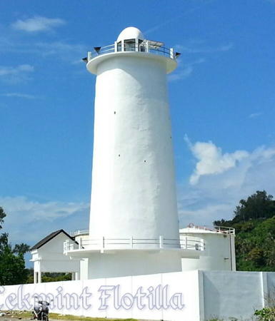
Ujung Lhok Me Light, Sabang, March 2016
Google Maps photo by Cekmint Flotilla
Sabang City (Pulau Weh) Lighthouses
Pulau Weh is the northwesternmost inhabited island of Indonesia, located about 40 km (25 mi) north of Banda Aceh. Also known as Sabang, the name of its largest town, the island has a population of about 25,000 and attracts tourists from Indonesia and elsewhere.

Pulau Rondo
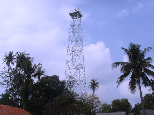
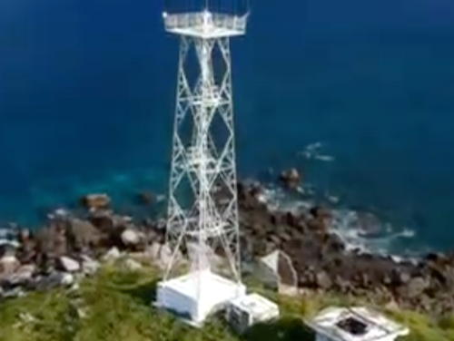
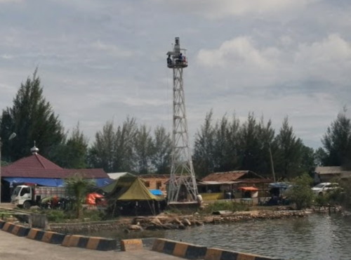
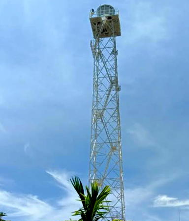
Date unknown. Active; focal plane 193 m (633 ft); two white flashes every 20 s. 40 m (131 ft) skeletal tower with lantern and gallery, painted white. Four red-roofed coast guard buildings. A photo is at right, Trabas has a distant view by Capt. Theo Hinrichs, Seftiawan Yuda Saputra has a distant view from the sea, and Bing has a satellite view of the station. Pulau Rondo is the northwesternmost island of Indonesia, about 25 km (15 mi) northwest of Pulau Weh in the Andaman Sea. The island is uninhabited but is sometimes visited by scuba divers. There is also a small Indonesian military outpost on the island. Accessible only boat. Site status unknown. ARLHS IDO-369; Admiralty F1300; NGA 22232.
Pulau Klah (Pulau Weh, Sabang) (2)
Date unknown (station established 1896). Active; focal plane 31 m (102 ft); white light, 7 s on, 23 s off. 10 m (33 ft) skeletal tower with lantern and gallery, painted white. Active coast station with numerous buildings. A closeup photo and a 2020 photo are available and Google has a satellite view of the station. The lighthouse is high enough to have escaped damage from the tsunami of 26 December 2004 but it might have been damaged by the earthquake. Located on a small island in the entrance to the harbor of Sabang. Accessible only by boat. Site status unknown. ARLHS IDO-208; Admiralty F1310; NGA 22244.
Ujung Lhok Me (Teluk Sabang, Sabang Harbor, Ujung Asam, Massam Point) (4)
2016 (station established 1905). Active; focal plane about 24 m (79 ft); three white flashes every 15 s. 20 m (66 ft) round concrete tower with lantern and gallery, painted white. A closeup photo is at the top of this page, Riana Nilasari has a 2021 closeup, another photo is available, Wahyu Noor Hidayat has a nice view of the lighthouse in context, and Google has a satellite view. Klaus Huelse has a historic postcard view of the original lighthouse, a skeletal tower. It was replaced by a concrete tower, which must have been destroyed by the tsunami, and then by another skeletal tower seen standing next to the new lighthouse in Dedy Saputra's December 2015 photo. Construction of the present tower began in March 2015. Located on the north side of the entrance to Sabang harbor. Site apparently open, tower closed. ARLHS IDO-340; Admiralty F1312; NGA 22240.
Sabang Signal Station
Date unknown. Active; focal plane unknown but at least 60 m (197 ft); continuous red light. Light mounted on a mast atop one of the station buildings. No photo available but Google has a satellite view of the station. Located atop Sabang Hill overlooking the harbor. Site status unknown. Admiralty F1313; NGA 22252.

Pulau Rondo Light, Sabang, July 2008
ex-Creative Commons photo
by Garis Depan Nusantara
Le Meule (Ujung Tapagaya, Ujung Baratlaut) (2)
Date unknown (station established 1905). Active; focal plane 29 m (95 ft); white flash every 5 s. 25 m (82 ft) square skeletal tower with gallery, painted white. A 2010 photo is at right and Google has a satellite view and a distant street view. Located at the northern point of Pulau Weh. Site apparently open, and Sandy Luthfi has a photo of visitors atop the tower. ARLHS IDO-153; Admiralty F1308; NGA 22260.
Ujung Seuke
Date unknown (1980s?). Active; focal plane 85 m (279 ft); white flash every 2.5 s. Approx. 40 m (131 ft) tapered square skeletal tower with gallery painted white. Duda Geblek has a 2018 photo, Hantu Pulau has a 2020 photo taken atop the tower, and Google has a satellite view of the station. Located on the southeastern tip of Pulau Weh about 10 km (6 mi) southeast of Sabang. Site status unknown. Admiralty F1314; NGA 22258.
* Balohan (Pelabuhan Sabang)
Date unknown. Active; focal plane 9 m (30 ft); yellow flash every 3 s. 9 m (30 ft) square skeletal tower with gallery painted white. Fajri Ayi has a photo, Wardi Sagala has a more distant view, and Google has a satellite view. Balohan is the terminal for ferries arriving at Pulau Weh from Banda Aceh. Located at the ferry terminal on the south coast of the island. Site open, tower closed. Admiralty F1313.5; NGA 22256.
Ujung Teupinpineung
Date unknown. Active; focal plane 9 m (30 ft); yellow flash every 5 s. 8 m (26 ft) square skeletal tower with gallery painted white. Aida Khairunnisa has a photo, Chairul Rijal has a view from atop the tower, and Google has a satellite view. Located at Pasi Jaboi, near the southern tip of Pulau Weh. Site status unknown. Admiralty F1313.8.

Le Meule Light, Sabang, March 2010
Aceh Department of Marine and Fisheries photo

Eastern Aceh Besar Regency (North Aceh) Lighthouses
Pulau Buru (Buro) (3)
Date unknown (station established 1889). Active; focal plane 14 m (46 ft); one long white flash every 8 s. 15 m (49 ft) square white skelettal tower. A photo is at right, Zulfikar Coet has a video of the new light and Google has a satellite view. This tower replaced a barbell-shaped white fiberglass tower, centered on a square base. The original lighthouse was a hexagonal skeletal tower with lantern. This lighthouse escaped serious damage by the 2004 tsunami because it is built on an isolated island too small (only 50 m (160 ft) in diameter) to trigger the great waves to rise up to destructive size. The light guides vessels around Ujung Baka (Cape Baka), the northernmost point of the island of Sumatra. Located about 15 km (9 mi) north of Banda Aceh and a similar distance south of Pulau Weh. Accessible only by boat. Site status unknown. Admiralty F1315; NGA 22268.
#Teluk Krueng Raya (Krueng Raja) (1)
Date unknown. Inactive since about 2016 and removed in 2020. 15 m (49 ft) square pyramidal skeletal tower, painted white. Phermana Rendy has a 2016 photo showing the new (taller) tower next to the original tower and another photo of the two towers is available but Google's satellite view shows only the new tower. Located on the waterfront of Krueng Raya, an industrial harbor about 25 km (15 mi) east of Banda Aceh. Site status unknown.
Teluk Krueng Raya (Krueng Raja) (2)
Around 2016. Active; focal plane about 30 m (98 ft); white flash every 3 s. Approx. 28 m (92 ft) square pyramidal skeletal tower, painted white. Phermana Rendy has a 2016 photo showing the new, taller tower next to the original tower. Site status unknown. Admiralty F1317; NGA 22272.
Krueng Raya (Bukit Soeharto, Ujung Batukapal)
Date unknown. Active; focal plane 35 m (115 ft); white light, 2 s on, 6 s off. 12.5 m (41 ft) white concrete tower. Bill Berry has a 2023 photo of the station entrance showing part of the tower and Google has an indistinct satellite view. Located on a promontory sheltering the east side of Krueng Raya bay. Site status unknown. Admiralty F1316; NGA 22276.

Pulau Buru Light, Cape Baka, September 2019
Google Maps photo by Anomancester

Pidie Regency Lighthouses
Ujung Pidie
Date unknown. Active; focal plane 60 m (197 ft); three white flashes every 20 s. 40 m (131 ft) skeletal tower with lantern and gallery, painted white. Four blue-roofed coast guard station buildings. No photo of the tower is available but Google has a satellite view of the station. This lighthouse marks a prominent cape about 80 km (50 mi) east of Banda Aceh and 16 km (10 mi) northwest of Sigli. Site status unknown. ARLHS IDO-344; Admiralty F1319; NGA 22286.
Sigli Approach (2)
Date unknown. Active; focal plane 12 m (39 ft); white flash every 3 s. 12 m (39 ft) square white skeletal tower mounted on a square platform supported by piles. Nawar Asa has a 2020 photo, Em Shal has a 2022 drone view, and Google has a satellite view. This tower replaced a white fiberglass tower. Located just off the beach at Sigli, a town of about 25,000 residents. Site open, tower closed. Admiralty F1320.2; NGA 22292.

Lhokseumawe City Lighthouses
Lhokseumawe is a seaport city of about 180,000 residents, the second largest city in Aceh; it includes Aceh's most important port facilities. There are two harbors, Kreung Geukueh on the west and Blang Lancang about 8 km (5 mi) to the east.
Kreung Geukueh West Breakwater (2)
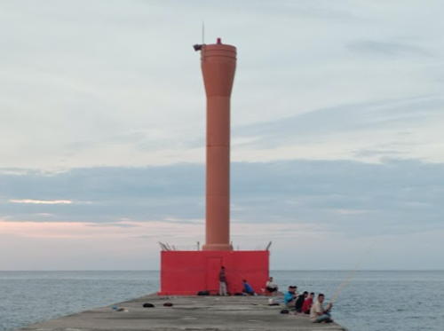
Date unknown. Active; focal plane about 15 m (49 ft); green light, 2 s on, 8 s off. Approx. 12 m (39 ft) octagonal cylindrical concrete tower painted green. A 2021 photo is available, Niel Harmaini has a distant street view, and Google has a satellite view. NGA lists a skeletal tower. Kreung Geukueh a general port of entry for Aceh. Located at the end of the west outer breakwater of Kreung Geukueh. Site status unknown. Admiralty F1321.3; NGA 22300.
* Kreung Geukueh West Inner Breakwater
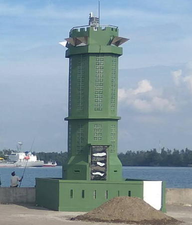
Date unknown. Active; focal plane about 10 m (33 ft); green flash every 3 s. 8 m (26 ft) octagonal cylindrical concrete tower on a square base, painted green. Ibnu Fatani's photo is at right, Niel Harmaini has a street view, and Google has a satellite view. Located on the short inner west breakwater of Kreung Geukueh. Site open, tower closed. Admiralty F1321.5; NGA 22305.
Kreung Geukueh Entrance Range Front
Date unknown. Active; focal plane about 30 m (98 ft); white light, pattern unknown. Approx. 30 m (98 ft) square skeletal tower on a platform supported by piles. No photo available but Google has a satellite view. Located just off the south edge of the harbor basin. Site and tower closed. Admiralty F1321.1.
Kreung Geukueh Entrance Range Rear
Date unknown. Active; focal plane about 40 m (131 ft); white light, pattern unknown. Approx. 40 m (131 ft) square skeletal tower. No photo available but Google has an indistinct satellite view. Located about 120 m (400 ft) south southwest of the front light. Site and tower closed. Admiralty F1321.11.
Kreung Geukueh East Inner Breakwater
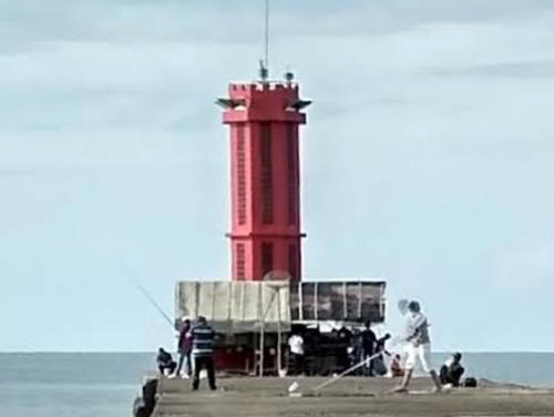
Date unknown. Active; focal plane about 10 m (33 ft); red flash every 3 s. 8 m (26 ft) octagonal cylindrical concrete tower on a square base, painted red. A photo is available, the light is in the left background of Ibnu Fatani's photo, Niel Harmaini has a distant street view, and Google has a satellite view. Located on the short inner east breakwater of Kreung Geukueh. Site status unknown. Admiralty F1321.4.
Kreung Geukueh East Breakwater (2)
Date unknown. Active; focal plane about 15 m (49 ft); red light, 2 s on, 8 s off. Approx. 12 m (39 ft) octagonal cylindrical concrete tower painted red. A photo is available, Niel Harmaini has a distant street view, and Google has a satellite view. NGA lists a skeletal tower. Located at the end of the east outer breakwater of Kreung Geukueh. Site status unknown. Admiralty F1321.2; NGA 22304.
Kreung Geukueh
Date unknown. Active; focal plane 15 m (49 ft); two white flashes every 10 s. 14 m (46 ft) square white skeletal tower. No photo available but Google has a satellite view. Located in an industrial area on the east side of the Kreung Geukueh harbor. Site and tower closed. Admiralty F1321; NGA 22312.

Inner West Breakwater Light, Kreung Geukueh, September 2017
ex-Google Plus photo by Ibnu Fatani
Blang Lancang West Breakwater
Date unknown. Active; focal plane 15 m (49 ft); three green flashes every 8 s. 12 m (39 ft) round green fiberglass tower. No photo available but Google has a satellite view. Located on the west breakwater of the Blang Lancang harbor. Site and tower closed. Admiralty F1323.2; NGA 22320.
Blang Lancang West Inner Breakwater
Date unknown. Active; focal plane 15 m (49 ft); green flash every 3 s. 12 m (39 ft) round green fiberglass tower. Muhamad Sofyan has a distant view (tower just right of center) and Google has a satellite view. Located on the west side of the entrance to the inner Blang Lancang harbor. Site and tower closed. Admiralty F1323.4; NGA 22324.
* Blang Lancang West Range Front
Date unknown. Active; focal plane 40 m (131 ft); white light, 1 s on, 1 s off. 36 m (118 ft) square pyramidal tower with gallery, painted with black and white horizontal bands. The lights are at upper left in a drone view and Google has a satellite view. Blang Lancang is an artificial harbor for liquid natural gas shipments, built on the east side of Lhokseumawe. Located on the west side of the harbor. Site status unknown, but the tower would be easy to see from nearby roads. Admiralty F1323.5; NGA 112-22351.
* Blang Lancang West Range Rear
Date unknown. Active; focal plane 44 m (144 ft); white, red or green light depending on direction, occulting once every 4 s. 44 m (144 ft) square pyramidal tower with gallery, painted with black and white horizontal bands. The lights are at upper left in a drone view and Google has a satellite view. Located 170 m (558 ft) west of the front light. Site status unknown, but the tower would be easy to see from nearby roads. Admiralty F1323.51; NGA 22352.
* Blang Lancang Entrance Range Front
Date unknown. Active; focal plane 40 m (131 ft); white light, 1 s on, 1 s off. 36 m (118 ft) square pyramidal tower with gallery, painted with black and white horizontal bands. Zulfitriansyah Putra has a photo of both range lights (also seen at right) and Google has a satellite view. This is the entrance range for Blang Lancang harbor. Located on the south side of the harbor. Site status unknown, but the tower would be easy to see from nearby roads. Admiralty F1322; NGA 22340.
* Blang Lancang Entrance Range Rear
Date unknown. Active; focal plane 45 m (148 ft); white light, occulting once every 8 s. 45 m (148 ft) square pyramidal tower with gallery, painted with red and white horizontal bands. Zulfitriansyah Putra has a photo of both range lights (also seen at right) and Google has a satellite view. Located 157 m (515 ft) southwest of the front light. Site status unknown, but the tower would be easy to see from nearby roads. Admiralty F1322.1; NGA 22344.

Front (left) and Rear Range Lights, Blang Lancang, January 2018
Google Maps photo by Zulfitriansyah Putra
Blang Lancang East Breakwater
Date unknown. Active; focal plane 15 m (49 ft); three red flashes every 8 s. 12 m (39 ft) round red fiberglass tower. Anak Rimba has the 2022 photo seen at right, another photo is available and Google has a satellite view. Located on the east breakwater of the Blang Lancang harbor. Site and tower closed. Admiralty F1323; NGA 22316.
Hagu (Lhokseumawe) (2) (?)
Date unknown (station established 1904). Active; focal plane 22 m (72 ft); white flash every 3 s. 20 m (66 ft) iron framework tower, painted white. The location of this light is unknown; it is not seen at the listed location. The original lighthouse was similar but the focal plane was only 15 m (49 ft). Located in Lhokseumawe, a city about 160 km (100 mi) east of Banda Aceh. Site status unknown. ARLHS IDO-157; Admiralty F1324; NGA 22356.
* Lhokseumawe
Date unknown. Active; focal plane 30 m (98 ft); white light, 2 s on, 8 s off. 30 m (98 ft) square skeletal tower painted white. Agus Nasution has a 2017 photo and another photo is available but the tower is somewhat difficult to distinguish in Google's satellite view of the location. NGA lists the light as Lhokseumawe Pier Head, but there is no pier here. Located on the beach near the foot of Merdeka Street in Lhokseumawe. Site open, tower closed. Admiralty F1326; NGA 22360.

Aceh Timur (East Aceh) Regency Lighthouses
Tanjung Jamboaye (Tanjung Jambuair, Diamantpunt, Diamond Point) (2)
Date unknown (station established 1905). Active; focal plane 44 m (144 ft); one long (1.5 s) white flash every 5 s. 40 m (131 ft) skeletal tower on an octagonal base. Lighthouse painted white. Coast guard station building. No photo available but Google has a satellite view of the station. The original lighthouse was a 26 m (85 ft) screwpile tower. This lighthouse is on Sumatra's northern "shoulder," marking the south side of the entrance to the Strait of Malacca. from the Andaman Sea. Located on Tanjung (cape) Jamboaye, about 40 km (25 mi) east of Lhokseumawe. Site status unknown. ARLHS IDO-083; Admiralty F1327; NGA 22364.

East Breakwater Light, Blang Lancang, Decemer 2022
Google Maps photo by Anak Rimba
* Idi (Idi Rayeuk, Edie Rajut)
1903. Active; focal plane 20 m (66 ft); white flash every 3 s. 20 m (66 ft) hexagonal iron skeletal tower painted white. No photo available and the light has not been found in Google's satellite view. The inland location listed is not compatible with the modest focal plane height; the light is probably on one of several towers near the harbor area. Google has a satellite view of a radar tower on the east side of the harbor entrance that could carry a light. Located off the main highway in downtown Idi Rayeuk, the capital of East Aceh Regency, about 50 km (30 mi) southeast of Tanjung Jambuair. Site open, tower closed. ARLHS IDO-133; Admiralty F1327.5; NGA 22368.
Ujung Peureula (Peureulak)
Date unknown. Active; focal plane 12 m (39 ft); two white flashes every 6 s. 12 m (39 ft) square skeletal tower, painted white and mounted on a platform supported by piles. No photo available but Google has an indistinct satellite view. Located off a low cape near Peureulak. Accessible only by boat. Site open, tower closed. Admiralty F1327.8; NGA 22369.
Kuala Beukah
Date unknown. Active; focal plane 16 m (52 ft); two white flashes every 10 s. 14 m (46 ft) square white skeletal tower. No photo available Google has an indistinct satellite view. Located at a small inlet about 3 km (2 mi) south of Ujung Peureula. Site status unknown. Admiralty F1328; NGA 22372.
* Kuala Langsa
Date unknown. Active; focal plane 20 m (66 ft); three white flashes every 10 s. 15 m (49 ft) square pyramidal skeletal tower painted white. Part of Lukmanul Hakim's street view is at right, Edy Susanto has a 2018 photo, Sayuti Nurdin has a 2022 photo, and Google has a satellite view. NGA lists this light as Kuala Beukah, an obvious error. Located on the waterfront of the estuary leading to Langsa, a city of about 150,000 residents. Site open, tower closed. Admiralty F1330.7; NGA 22392.

Kuala Langsa Light, Aceh Timur, June 2015
Google Plus street view by Lukmanul Hakim
Kuala Langsa Range Rear
Date unknown. Active; focal plane 18 m (59 ft); white light, 2 s on, 2 s off. 18 m (59 ft) square skeletal tower, painted white and mounted on a platform supported by piles. A distant view is available and Google has a satellite view. This is an approach range for Langsa. The front range is on a similar tower 9 m (30 ft) tall. Located just offshore near Langsa. Accessible only by boat. Site open, tower closed. Admiralty F1330.1; NGA 22380.

Tamiang Regency Lighthouse
Ujung Tamiang
Date unknown. Active; focal plane 44 m (144 ft); three white flashes every 20 s. 40 m (131 ft) square skeletal tower, painted white, rising from an octagonal 2-story white concrete building. Syamsul Bahri has a 2017 closeup photo, Guntur Ardhana has a photo of the station and the base of the lighthouse, Suwandi Andi has a distant view, and Google has a satellite view. This is a staffed coast guard station. Located just off a swampy cape about 35 km (22 mi) east of Langsa. Site status unknown. ARLHS IDO-345; Admiralty F1334; NGA 22394.

Information available on lost lighthouses:

Notable faux lighthouses:

Adjoining pages: East: West Malaysia West Coast | Southeast: Northeastern Sumatra | Southwest: Western Aceh

Return to the Lighthouse Directory index | Ratings key

Posted April 13, 2006. Checked and revised January 4, 2024. Lighthouses: 37. Site copyright 2024 Russ Rowlett and the University of North Carolina at Chapel Hill.