Lighthouses of Indonesia: Northern Papua

The Republic of Indonesia has been independent since 1945 after having been the Dutch East Indies for more than 350 years. It is a huge country, stretching along both sides of the Equator for more than 46 degrees of longitude (roughly 5100 km or 3200 miles). Comprised of some 17,000 islands (more than 6000 inhabited islands), it has hundreds of major aids to navigation.

Indonesia is divided into 38 provinces (provinsi) and the provinces are subdivided into county units called regencies (kabupaten). The lighthouses on this page are in Indonesian Papua (western New Guinea). In 1828 the Dutch extended their claim to the western half of New Guinea, the world's second-largest island, but they established no major settlements until nearly 1900. When Indonesia became independent in 1949 Papua was excluded and remained under Dutch control. Following strong Indonesian effrots to claim control an agreement in 1962 provided for a transitional period under United Nations administration. In 1969 an asembly of elder leaders decided to join Indonesia. However an independence movement called the Free Papua Movement (OPM) continues and a varying degree of unrest has persisted to the preent day.

This page includes the lighthouses of the north coast of Indonesian Papua in the provinces of Papua and Central Papua. Central Papua was carved out of Papua Province in 2022. Central Papua also has a south coast, and lighthouses of that coast are described on the Southern Papua page.

More than 700 languages are spoken in Indonesia. The official national language, Indonesian (Bahasa Indonesia), was standardized from a form of Malay that served as a lingua franca across the archipelago. In Indonesian a lighthouse is a mercusuar or a menara suar. Tanjung is a cape, ujung is a headland or point of land, bukit is a hill, sungai is a river, kuala or muara is an estuary or river mouth, pulau is an island, karang is a reef, batu is a rock, laut is a sea, selat is a strait, teluk is a bay, pelabuhan is a harbor, and labuhan is a port. It's also worth knowing that the word for an island is nusa in Balinese and gili in the Sasak language spoken on Lombok and in western Sumbawa.

Aids to navigation in Indonesia are operated and maintained by the Directorate of Marine Navigation within the Directorate General of Sea Transportation

ARLHS numbers are from the ARLHS World List of Lights. Admiralty numbers are from volumes F and Q of the Admiralty List of Lights & Fog Signals. U.S. NGA List numbers are from Publications 111 and 112.

General Sources
World of Lighthouses - Indonesia
Photos by various photographers available from Lightphotos.net.
Online List of Lights - Indonesia - Papua - Vol Q and Vol. F
Photos by various photographers posted by Alexander Trabas. Volume Q includes light south of the Equatir and Volume F has lights north of the Equator.
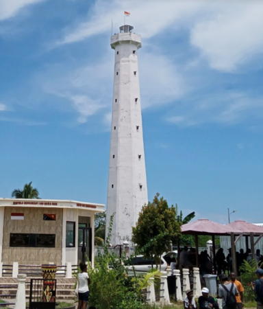
 

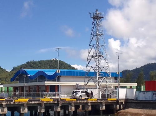
Oinake Light, Jayapura Regency, November 2019
Google Maps photo by Suripto Tigalima

Central Papua Province Lighthouses

Nabire Regency Lighthouses
Nabire Regency occupies the south coast of the Cenderawasih Bay ("Bird of Paradise Bay") above the "neck" of the Bird's Head Peninsula.

Karang-Karang Tydeman
Date unknown. Active; focal plane 11 m (36 ft); white flash every 6 s. 11 m (36 ft) white tower, probably skeletal, on a platform supported by piles. No photo available and Bing has only a fuzzy satellite view of the reef. Located at the east end of a long reef complex in the center of the entrance to the Cenderawasih Gulf. Accessible only by boat. Site status unknown. Admiralty Q3395.3; NGA 26106.
Pulau Kabuai (Kubuai) (2)
2010 (?). Active; focal plane 33 m (108 ft); white flash every 5 s. 30 m (98 ft) skeletal tower, painted white. Soffa Mustoffa has a closeup 2022 photo and Google has a satellite view. This light and the next one guide ships through the reefs to Nabire. NGA formerly listed a light with a 14 m (46 ft) focal plane. Located on a tiny islet in the southwestern Cenderawasih Gulf. Accessible only by boat. Site status unknown. Admiralty Q3395.4; NGA 26107.
Pulau Notabari
Date unknown. Active; focal plane 24 m (79 ft); yellow flash every 4 s. 24 m (79 ft) yellow tower on a platform supported by piles. No photo available and Bing has only a fuzzy satellite view showing the platform. Located on a reef about 40 km (25 mi) northwest of Nabire. Accessible only by boat. Site status unknown. Admiralty Q3395.59; NGA 26101.
Nabire Oil Terminal
Date unknown. Active; focal plane about 22 m (72 ft); light characteristic unknown. Approx. 20 m (66 ft) square skeletal tower enclosed with a daymark colored with red and white horizontal bands. No closeup photo available but Google has a satellite view and the light is just beyond the big tank, at the base of the pier, in an aerial view of the terminal. Located at the terminal at the southern end of the Cenderawasih Gulf. Site status unknown. Admiralty Q3395.87.
* Nabire
2019(?). Active; focal plane 23 m (75 ft); yellow flash every 4 s. 20 m (66 ft) triangular cylindrical skeletal tower. This appears to be a coast guard communications tower. Firt Luqman has a July 2019 photo but the tower is too new to appear in Google's satellite view. Located on the Nabire waterfront. Site open, tower closed. Admiralty Q3395.82.
Ujung Kimbo (Teluk Kimi, Nabire)
Date unknown. Active; focal plane 23 m (75 ft); white flash every 6 s. 20 m (66 ft) skeletal tower, painted white. Sukarno Makawaehe has a 2020 photo (a portion is at right), a similar but darker photo is available, the light is in the upper right corner of Arief Hidayat's aerial photo of the port and Google has a satellite view. Located on a headland sheltering the harbor of Nabire, the regency capital on the east side of the Cenderawasih Gulf. Site status unknown. Admiralty Q3395.8; NGA 26104.
Pulau Jaunan
Date unknown. Active; focal plane 20 m (66 ft); white flash every 5 s. 20 m (66 ft) skeletal tower, painted white. Raimond Rumatray has a distant drone view and a drone view of visitors atop the tower and Google has a satellite view. The Admiralty and NGA list the light as "Nabire," although it is 32 km (20 mi) north of that town. Located on a small island, the westernmost in a group of islands. Accessible only by boat. Site status unknown. Admiralty Q3395.6; NGA 26100.


Ujung Kimbo Light, Nabire, October 2020
Google Maps photo by Sukarno Makawaehe

Pulau Jaunan Reef
Date unknown. Active; focal plane 20 m (66 ft); red flash every 4 s. 20 m (66 ft) red skeletal tower on a platform supported by piles. No photo available but Bing has a satellite view. The approach channel to Nabire passes just to the west of this light. Located at the west end of the large reef surrounding Pulau Jaunan, about 2 km (1.25 mi) west of the lighthouse. Accessible only by boat. Site open, tower closed. Admiralty Q3395.64.

Papua Province Lighthouses

Supiori Regency: Mapia Atoll Lighthouses
The Mapia atoll (Kepulauan Mapia) is located far out in the Pacific, about 200 km (125 mi) north of Manokwari, West Papua. These islands represent the northeasternmost extension of Indonesian territory. In the 19th century the atoll was claimed by Spain as part of the Caroline Islands. After the Spanish-American War in 1898 Spain sold its Caroline Islands colony to Germany but the treaty failed to include Mapia in its definition of the territory. This gave the Netherlands the opportunity to assert its own claim and add the islands to the Dutch East Indies; thus they were inherited by Indonesia. A small settlement on Pulau Bras supports Indonesia's coast guard and border control station.

Pulau Fanildo
2007. Active; focal plane 33 m (108 ft); two white flashes every 12 s. 30 m (98 ft) skeletal tower. Two 1-story station buildings. No photo available but Google has a satellite view of the station. The lighthouse marks the northwestern corner of the Mapia atoll. Accessible only by boat. Site status unknown. Admiralty F2111.98.
Pulau Bras
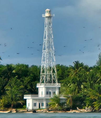
2007. Active; focal plane 45 m (148 ft); two white flashes every 12 s. 40 m (131 ft) square skeletal tower with lantern and gallery mounted atop the coast guard and border patrol station. Tower painted white, lantern red. A 2023 photo is at right and Google has a satellite view of the station. This new lighthouse marks the northeastern corner of the Mapia atoll. Accessible only by boat. Site status unknown. Admiralty F2111.95.
Pulau Pegun (1 and 2)
Date unknown. Active; focal plane 30 m (98 ft); white flash every 5 s. 30 m (98 ft) skeletal tower. Several 1-story station buildings. A very distant aerial photo (1/10 the way down the page) is available and Google has a satellite view of the station. showing two towers; the active tower is probably the one on the left. NGA has placed the light erroneously in Palau. Located on the southern tip of Pulau Pegun, marking the southern end of the Mapia atoll. Accessible only by boat. Site status unknown. ARLHS PAL-002; Admiralty F2111.9; NGA 111-10932.


Pulau Bras Light, Mapia, September 2023
photo by travel site come2Indonesia.com


Supiori Regency Lighthouses
The Biak Islands (known under Dutch rule as the Schouten Islands) are spread across the entrance to the Cenderawasih Bay. Supiori, Biak, and Numfor are the largest of the islands. The islands were all included in the Biak Numfor Regency until 2004, when Supiori and nearby islands were split off as the separate Supiori Regency. The regency's population is about 25,000.

Pulau Bepondi (1 and 2)
Date unknown. Active; focal plane 23 m (75 ft); white flash every 5 s. Approx. 20 m (66 ft) square white skeletal tower. Four 1-story station buildings nearby. No photo available but Google has a satellite view showing two towers at the station. Pulau Bepondi is a small island about 30 km (19 mi) northwest of the large island of Pulau Biak and 160 km (100 mi) northeast of Manokwari. Located on the southwestern shore of the island. Site status unknown. Admiralty Q3391.5; NGA 26053.
Pulau Bepondi North
2007. Active; focal plane 33 m (108 ft); two white flashes every 12 s. 30 m (98 ft) "white beacon," possibly a concrete tower. No photo available and the lighthouse may be too new to appear in Google's satellite view. Located on the northern tip of the island. Accessible only by boat. Site status unknown. Admiralty Q3391.7.
Korido Approach
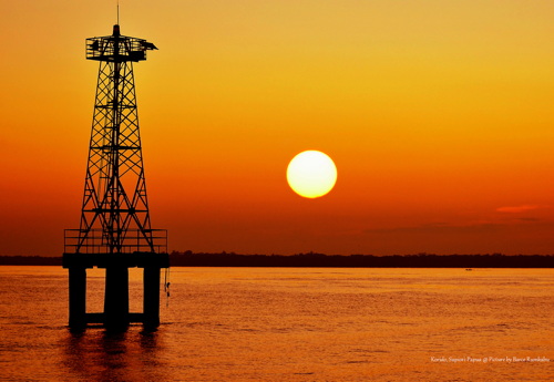
Date unknown. Active; focal plane 13 m (43 ft); green flash every 10 s. Approx. 15 m (49 ft) square pyramidal skeletal tower mounted on a platform supported by piles. Barce Rumkabu's sunset photo is at right, this is the more distant light in Rizky Pairin's 2021 photo and Google has a satellite view. Located at the edge of a reef on the east side of the entrance to Korido, on the south coast of Pulau Supiori. Accessible only by boat. Site open, tower closed. Admiralty Q3392.73.

Korido Approach Light, Pulau Supiori, September 2015
Flickr photo copyright Barce Rumkabu; permission requested
Pelabuhan Korido
Date unknown. Active; focal plane 15 m (49 ft); red flash every 10 s. 15 m (49 ft) square pyramidal skeletal tower mounted on a platform supported by piles. Anna Maria Michael has the 2021 photo at right, this is the closer light in Rizky Pairin's 2021 photo, Harry Fainsenem has a distant 2024 view, and Google has a satellite view. Located a short distance off the pier at Korido. Accessible only by boat. Site open, tower closed. Admiralty Q3392.72.
Pulau Rani
Date unknown. Active; focal plane 17 m (56 ft); white flash every 3 s. 15 m (49 ft) square skeletal tower, painted white. No photo available but Google has a satellite view. Located on a small island oabout 25 km (15 mi) southwest of Korido. Site status unknown. Admiralty Q3392.7; NGA 26056.
Teluk Wabudori
Date unknown. Active; focal plane 15 m (49 ft); green (?) flash every 6 s. 15 m (49 ft) round barbell-shaped green fiberglass tower mounted on a platform supported by piles. No photo available but Google has a satellite view. C-Map charts the light with a white flash. Located on the west side of the entrance to the sheltered harbor of Wabudori (formerly Jenggerbun) on the north coast of Pulau Supiori. Accessible only by boat. Site open, tower closed. Admiralty Q3392.75; NGA 26055.

Biak Numfor Regency Lighthouses
Pulau Biak and Pulau Supiori are separated only by a very narrow channel; a bridge connects the islands. Taken together the islands are about 125 km (75 mi) long and up to 37 km (23 mi) wide. Biak has a population of about 125,000.

Pulau Numfor (Yerunana)
Date unknown. Active; focal plane 45 m (148 ft); white flash every 5 s. 16 m (52 ft) skeletal tower, painted white. No photo available but Google has a satellite view. Pulau Numfor is an island about 25 km (15 mi) in diameter in the northwestern corner of the Cenderawasih Gulf. Numfor is closer to Supori than it is to Biak, but it remains in the Biak Numfor Regency. Located near Kameri on the northwestern side of the island, about 65 km (40 mi) east of Manokwari. Site status unknown. ARLHS IDO-179; Admiralty Q3392; NGA 26052.


Pelabuhan Korido Light, Korodo, July 2021
Google Maps photo by Anna Maria Michael

Tanjung Basari (Pulau Miosmboi) (?)
Date unknown. Active(?); focal plane 16 m (52 ft); white light, 2 s on, 6 s off. Approx. 15 m (49 ft) square white skeletal tower. No photo available. Google has an indistinct satellite view of the listed location, an islet locally called Meos Bo (Miosmboi). However a 2023 photo confirms that there is no lighthouse on or near the islet. It is possible that the light is well offshore of the reef and is not shown in satellite views. Located on a rocky reef just off the eastern tip of Pulau Biak. Accessible only by boat but easy to see from the beach. Site open, tower closed. Admiralty Q3392.8; NGA 26058.
Pulau Rasi
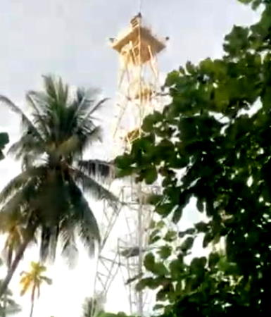
Date unknown. Active; focal plane 14 m (43 ft); three white flashes every 15 s. 13 m (43 ft) skeletal tower, painted white. Leofandy Gosal has a 2021 closeup photo and a video of the tower (a frame from the video appears at right) and Bing has an indistinct satellite view. Located on a small island at the southeastern end of the Biak Islands. Accessible only by boat. Site status unknown. Admiralty Q3393.6; NGA 26088.
Sorido Outer Range Front
Date unknown. Active; focal plane 15 m (49 ft) (?); white light, 1 s on, 1 s off. 10 m (33 ft) square skeletal tower painted white. Kakes Yolay has a very distant view and Google has a satellite view. The range guides vessels around the east end of the reef that shelters the south coast of Biak; the slack water behnd the reef is called the Laguna Sorido. Located at the south shoreline in Biak. Site status unknown. Admiralty Q3393; NGA 26060.
Sorido Outer Range Rear
Date unknown. Active; focal plane 23 m (75 ft) (?); white light, 1 s on, 1 s off. 15 m (49 ft) square skeletal tower painted white. No photo available but Google has a satellite view. Located onshore about 260 m (850 ft) northwest of the front light. Site status unknown. Admiralty Q3393.1; NGA 26064.
Sorido Inner Range Front (2?)
Date unknown. Active; focal plane 17 m (56 ft) (?); white light, 4 s on, 4 s off. 10 m (33 ft) (?) square skeletal tower painted white. Ronni Berotabui has a distant street view, Richard Monny has an aerial view (tower is at the right end of the port), and Google has a satellite view. The tower appears to be higher than the listed height. Located on the west end of the main quay at Kota Biak. Site status unknown. Admiralty Q3393.3; NGA 26068.
Sorido Inner Range Rear (2?)
Date unknown. Active; focal plane 17 m (56 ft) (?); white light, 4 s on, 4 s off. 15 m (49 ft) (?) square skeletal tower painted white. The lighthouse is on the left, near the pier, in Richard Monny's aerial view and Google has a satellite view. Located 420 m (1/4 mi) west northwest of the front light. Site status unknown. Admiralty Q3393.31; NGA 26072.

Pulau Rasi Light, Biak, July 2021
frame 0:24 from Google Maps video by Leofandy Gosal

Yapen Islands Regency Lighthouses
Pulau Yapen is an island about 170 km (105 mi) long but only about 25 km (15 mi) at its widest; it lies east to west across the northeastern Cenderawasih Bay southeast of Pulau Biak.

Tanjung Rainbawi (Tanjung Rainbawa)
Date unknown. Active; focal plane 26 m (85 ft); white flash every 3 s. 20 m (66 ft) skeletal tower, painted white. No photo available but Bing has an indistinct satellite view. The lighthouse may have been replaced recently, since NGA formerly listed a 16 m (52 ft) tower. Located at the eastern tip of the island of Yapen, marking the east entrance to the Cenderawasih Gulf through the narrow Kurudu Strait. Site status unknown. ARLHS IDO-322; Admiralty Q3393.7; NGA 26108.
* Dawai
Date unknown. Active; focal plane about 23 m (75 ft); light characteristics unknown. Approx. 20 m (66 ft) square white skeletal tower. A view from the sea is available, Jiří Hruška has a fuzzy street view from the pier, and Google has a satellite view. Located at the Dawai ferry terminal in the Mereruni District of eastern Yapan. Site open, tower closed. Not listed by the Admiralty.
* Serui (2)
2009(?). Active; focal plane 17 m (56 ft); white flash every 3 s. 15 m (49 ft) square pyramidal skeletal tower, painted white. Turbo Auri's 2023 photo is at right, Hendra Purnomo has a photo, Ikal Ichwan has a twilight photo, Bang Ramdhani has a 2023 photo, Esa Daya Lestari has a 2020 photo (misidentified as Dawai), M. Andi has a view from the sea, and Google has a satellite view. Serui is the principal town on Pulau Yapen. Located at the head of a short pier on the waterfront of Serui, on the south side of Pulau Yapen. Accessible by walking the pier. Site open, tower closed. Admiralty Q3394.5; NGA 26084.
Serui Pertamina
Date unknown. Active; focal plane 10 m (33 ft); white flash every 3 s. Approx. 8 m (26 ft) square tower mounted on four robust piles. A photo is available and Google has a satellite view. Located at the foot of the pier at the Pertamina oil terminal on the west side of Serui. Site and tower closed. Admiralty Q3394.

Serui Light, Serui, April 2023
Google Maps photo by Turbo Auri
* Ansus
Date unknown. Active; focal plane about 14 m (46 ft); light characteristics unknown. Approx. 12 m (39 ft) round barbell-shaped fiberglass tower. No photo available but Google has a satellite view. Located at the ferry terminal in the Ansus District of western Yapan. Site open, tower closed. Not listed by the Admiralty.
Tanjung Woka (2?)
Date unknown. Active; focal plane 40 m (131 ft); white flash every 3 s. 10 m (33 ft) (?) square skeletal tower with gallery, painted white. No photo available but Google has a satellite view. The tower appears to be taller than the 10 m listed by NGA. Located on the west end of Pulau Yapen. Accessible only by boat. Site status unknown. Admiralty Q3395; NGA 26096.

Waropen Regency Lighthouses
Waropen Regency is a mainland region on the east coast of Cenderawasih Bay south of Pulau Yapen.

Tanjung Kamengsenu (Kamarsano)
Date unknown. Active; focal plane 53 m (174 ft); white flash every 4 s. Approx. 40 m (131 ft) square tapered skeletal tower with gallery, painted white. Two small station buildings. No photo available but Google has a satellite view of the station. Located on a prominent cape on the east side of the Cenderawasih Gulf. Site status unknown. Admiralty Q3395.9; NGA 26104.5.
Pulau Naufi (Pulau Nau)
Date unknown. Active; focal plane 35 m (115 ft); one long white flash every 10 s. Described by NGA only as a beacon, this is probably a skeletal tower. No photo available but Google has a satellite view that probably shows the light to the right of a monument. Located at the northern tip of an island off the east coast of the Cenderawasih Gulf. Accessible only by boat. Site status unknown. Admiralty Q3396; NGA 26105.
* Tanjung Worisanua (Pelabuhan Waropen) (1 and 2)
Date unknown. Active; focal plane 23 m (75 ft); white flash every 6 s. Approx. 20 m (66 ft) square white skeletal tower. Part of a 2023 view is at right, Ifan Nova has a view from the sea (tower on the right), and Google has an indistinct satellite view. The tower stands next to an older tower about half as tall. Ferries link this port to Serui on Pulau Yapen. Located just west of the piers at Waropen. Site open, tower closed. Admiralty Q3396.2; NGA 26105.5.

Pelabuhan Waropen Light, Waropen, February 2023
Google Maps photo by D E L L

Mamberamo Raya Regency Lighthouse
Mamberamo Raya Regency occupies the vicinity of Tanjung Perkam (Cape D'Urville), the northwestern "shoulder" of New Guinea and the eastern entrance to Cenderawasih Bay.

Sungai Mamberamo
Date unknown. Active; focal plane 31 m (102 ft); white flash every 5 s. 16 m (52 ft) skeletal tower, painted white. No photo available but Google has an indistinct satellite view (note the shadow!). The light guides ships to the port of Teba, about 2 km (1.25 mi) from the mouth of the Mamberamo River. Located on the east side of the river entrance about 3 km (2 mi) southwest of Tanjung Perkam (Cape D'Urville). Site status unknown; this is a wild, heavily forested area. Admiralty Q3396.6; NGA 26112.

Sarmi Regency Lighthouses
Sarmi Regency includes a long section of the coast of northwestern Papua. Mostly wild, it is known for having 87 native tribes, each speaking a different language. The name of the regency is an acronym, each letter being the first letter of the name of one of the more numerous tribes.

Pulau Liki (Kumamba Liki)
Date unknown. Active; focal plane 45 m (141 ft); one long white flash every 5 s. 40 m (131 ft) skeletal tower, painted white. Four 1-story coast guard station buildings. Christian Ale Perdana has a 2023 drone view and Google has a satellite view of the station. Located on the northern tip of Pulau Liki, about 40 km (25 mi) north of Sarmi. Accessible only by boat. Site status unknown. ARLHS IDO-210; Admiralty Q3396.8; NGA 26092.
Pulau Armo (Pulau Nirumoar)
Date unknown. Active; focal plane 16 m (52 ft); six quick white flashes and one long white flash every 15 s. 16 m (52 ft) post with gallery mounted on a square platform supported by piles. Upper half of the tower painted yellow, lower half black. No photo available but Google has a satellite view. Located on a reef at the southern end of Pulau Nirumoar, an island about 10 km (6 mi) southeast of Pulau Liki. Accessible only by boat. Site status unknown. Admiralty Q3396.9; NGA 26115.
Sarmi (2)
Date unknown. Active; focal plane 32 m (105 ft); white flash every 5 s. 16 m (52 ft) skeletal tower, painted white. No photo available but Bing has a satellite view. This light recently replaced a much shorter tower. Located on a promontory near Sarmi, about 140 km (225 mi) west northwest of Jayapura. Site status unknown. Admiralty Q3397; NGA 26116.

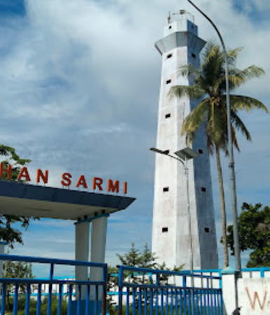
Pelabuhan Sarmi Light, Sarmi, June 2023
Google Maps photo by Ginty Intan Mawarti
* Pelabuhan Sarmi
Date unknown. Active; focal plane about 25 m (82 ft); white light, pattern unknown. Approx. 22 m (72 ft) octagonal white concrete tower. Ginty Intan Mawarti's 2023 photo is above right, Tom Ramand has an April 2017 photo, Eragon Black has an October 2017 street view, and Google has a satellite view. Located on the waterfront at Sarmi. Site open, tower closed. Not listed by the Admiralty.
Holmaffin
Date unknown. Active; focal plane 14 m (46 ft); white flash every 5 s. Approx. 15 m (49 ft) "white beacon." No photo available and the light has not been found in Google's satellite view. There being no port in this area it's likely the light is actually on a shoal offshore. Located about 20 m (13 mi) east of Sarmi. Site status unknown. Admiralty Q3397.5; NGA 26117.
Pulau Yamna (Jamna)
Date unknown. Active; focal plane 23 m (75 ft); white flash every 6 s. No description and no photo available but Bing has an indistinct satellite view. Located on Pulau Yamna, an island about 50 km (30 mi) east of Sarmi. Accessible only by boat. Site status unknown. Admiralty Q3397.6; NGA 26118.

Jayapura Regency Lighthouses
Tanjung Kamdara (Kamadara)
Date unknown. Active; focal plane 43 m (141 ft); white light, 5 s on, 5 s off. Approx. 40 m (131 ft) octagonal white concrete tower with lantern and gallery. Several coast guard station buildings. Rima Nusantriani Banurea's 2024 photo is at right, Steve Christiantara has a 2014 photo, Stevanus Rumbino has a 2018 photo, Feby Waipon has a 2022 photo, and Google has a satellite view. Located on a promontory near Demta about 120 km (75 ft) west of Jayapura. Site open, tower closed. Admiralty Q3397.8; NGA 26119.

Tanjung Kamdara Light, Demta, September 2024
Google Maps photo by Rima Nusantriani Banurea
Tanjung Kelapa (Tanjung Ormu)
Date unknown. Active; focal plane 12 m (39 ft); white flash every 6 s. 10 m (33 ft) square skeletal tower. No photo available but Google has an indistinct satellite view. The area is accessible only by boat. Located on a promontory about 50 km (30 mi) west of Tanjung Suaja. Site status unknown. Admiralty Q3397.95; NGA 26119.5.

Jayapura City Lighthouses
Jayapura, the capital of Papua Province, is a city of more than 400,000 people; it is the largest city on the island of New Guinea. Known as Hollandia under Dutch control, it was recaptured from Japanese occupation by an Alled amphibious invasion in April 1944. Jayapura has a beautiful semicircular harbor framed by mountains.

Tanjung Suaja (Soeadja Moko) (1)
Date unknown. Inactive. Approx. 16 m (52 ft) octagonal white skeletal tower with lantern and gallery. A drone view of the old and new towers is available and the old tower stands next to the active lighthouse in Google's satellite view. Tanjung Suaja is a mountainous promontory that shelters the approach to Jayapura, about 4 km (2.5 mi) east of the city.
Tanjung Suaja (Soeadja Moko) (2)
2009(?). Active; focal plane 215 m (705 ft); three white flashes every 24 s. 20 m (66 ft) square white skeletal tower. Keeper's houses and other station buildings. A drone view of the old and new towers is available and Google has a good satellite view. A 2009 Australian Notice to Mariners lists the new light. Located atop the mountain, but possibly accessible by road. Site status unknown. ARLHS IDO-281; Admiralty Q3398; NGA 26120.
* Jayapura Entrance North
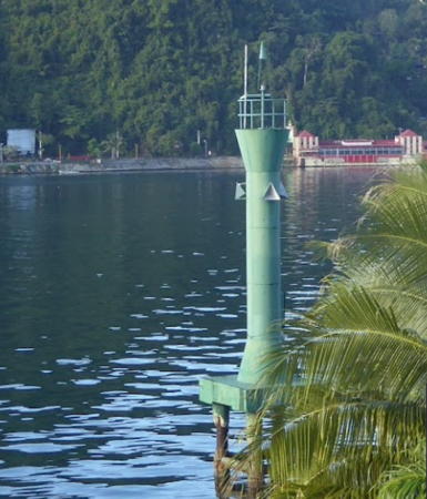
Date unknown. Active; focal plane 13 m (43 ft); green flash every 5 s. 13 m (43 ft) round hourglass-shaped green tower, mounted on a square concrete platform supported by concrete piles. A 2014 photo is at right, Ralph Sanderson contributed a 2007 photo , and Google has a satellite view. Located just offshore near the Swiss-Belhotel Papua, marking the north side of the entrance to the harbor. Accessible only by boat. Site status unknown. Admiralty Q3398.9; NGA 26123.5.
Noebai Nan Range Front
Date unknown. Active; focal plane 17 m (56 ft); quick-flashing white light. 15 m (49 ft) square skeletal tower, painted white and carrying a triangular slatted daymark, point up. The tower is at the far left in Arief Rachman Ashar's photo of the harbor, Wahyu Wijanarko has a street view, and Google has a satellite view. Located near the south end of the waterfront in Jayapura. Site status unknown. Admiralty Q3399; NGA 26124.

Jayapura Entrance North Light, Jayapura, September 2014
Google Maps photo by Grahabudayaindonesia
* Noebai Nan Range Rear
Date unknown. Active; focal plane 22 m (72 ft); white light occulting once every 4 s. 20 m (66 ft) square skeletal tower, painted white and carrying a triangular slatted daymark, point down. Richard Monnyhas a 2015 photo, the lighthouse is at the left in Parno Abu Hammam's photo, Wahyu Wijanarko has a street view, and Google has a satellite view. Located near the Bank of Papua in downtown Jayapura, 150 m (165 yd) west of the front light. Site open, tower closed. Admiralty Q3399.1; NGA 26128.
* Jayapura Harbor
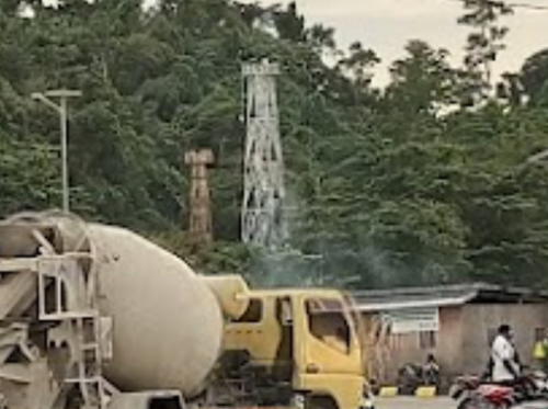
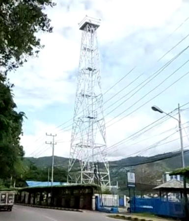
2013. Active; focal plane 38 m (125 ft); white flash every 5 s. 30 m (98 ft) square skeletal tower with gallery, painted white. Wahyu Wijanarko has the street view at right, Asmatriadi Anwar has a view across the harbor, this light is in the distance to the right of center in Parno Abu Hammam's photo, a view from the Entrance North Light is available, and Google has a satellite view. Located on Batu Putih Street on the south side of Jayapura Harbor. Site open, tower closed. Admiralty Q3399.5.
Jayapura Entrance South (Hollandia Baai)
Date unknown. Active; focal plane 13 m (43 ft); red flash every 4 s. 13 m (43 ft) round hourglass-shaped red tower, mounted on a square concrete platform supported by concrete piles. The light is in the center of a distant aerial photo, Otto Wooduck has a distant street view, and Google has a satellite view. Located on a shoal marking the south side of the entrance to Jayapura harbor. Accessible only by boat. Site open, tower closed. Admiralty Q3398.8; NGA 26123.
[Madurau]
Date unknown. Active; focal plane 13 m (43 ft); red flash every 5 s. 13 m (43 ft) post mounted on a triangular pier. Farid Rohman Sholeh has a closeup photo and Google has a satellite view. Located on the northeast side of Pulau Madurau, a small island at the southern entrance to Jayapura harbor. Accessible only by boat. Site open, tower closed. Admiralty Q3399.7.
* Oinake
Date unknown (1990s?). Active; focal plane 200 m (656 ft); white flash every 10 s. Approx. 37 m (121 ft) octagonal concrete tower with lantern and gallery. The lighthouse is unpainted white concrete. Suripto Tigalima's 2019 photo is at the top of this page, Ian Uzumaki has a 2018 photo, Google has a 2022 street view, and Bing has a satellite view. This lighthouse is located at the border between Indonesian Papua and the independent nation of Papua New Guinea, near the town of Watung, Papua New Guinea, and about 50 km (30 mi) east of Jayapura, the capital of Indonesia's Papua province. Argananta Yuwana has a street view taken at the border crossing. Accessible by road. Site open, tower closed. Admiralty Q3399.8; NGA 26129.

Jayapura Harbor Light, Jayapura, April 2023
Google Maps photo by Wahyu Wijanarko

Information available on lost lighthouses:

Notable faux lighthouses:

Adjoining pages: East: Northern Papua New Guinea | West: Northwestern Papua

Return to the Lighthouse Directory index | Ratings key

Posted December 31, 2008. Checked and revised February 17, 2025. Lighthouses: 50. Site copyright 2025 Russ Rowlett and the University of North Carolina at Chapel Hill.