Lighthouses of Indonesia: Southwestern Papua

The Republic of Indonesia has been independent since 1945, after having been the Dutch East Indies for more than 350 years. It is a huge country, stretching along both sides of the Equator for more than 46 degrees of longitude (roughly 5100 km or 3200 miles). Comprised of some 17,000 islands (more than 6000 inhabited islands), it has hundreds of major aids to navigation.

Indonesia is divided into 38 provinces (provinsi) and the provinces are subdivided into county units called regencies (kabupaten). The lighthouses on this page are in Indonesian Papua (western New Guinea). In 1828 the Dutch extended their claim to the western half of New Guinea, the world's second-largest island, but they established no major settlements until nearly 1900. When Indonesia became independent in 1949 Papua was excluded and remained under Dutch control. Following strong Indonesian effrots to claim control an agreement in 1962 provided for a transitional period under United Nations administration. In 1969 an asembly of elder leaders decided to join Indonesia. However an independence movement called the Free Papua Movement (OPM) continues and a varying degree of unrest has persisted to the preent day.

This page describes lighthouses on the south and west coasts of West Papua Province and Southwest Papua Province. These provinces include the oddly-shaped Doberai or Bird's Head (Vogelkop) Peninsula at the northwestern corner of New Guinea. Their south coasts face southwest on the Arafura Sea and Seram Sea. Lighthouses of the north coasts of both provinces are described on the Western Papua North Coast page.

More than 700 languages are spoken in Indonesia. The official national language, Indonesian (Bahasa Indonesia), was standardized from a form of Malay that served as a lingua franca across the archipelago. In Indonesian a lighthouse is a mercusuar or a menara suar. Tanjung is a cape, ujung is a headland or point of land, bukit is a hill, sungai is a river, kuala or muara is an estuary or river mouth, pulau is an island, karang is a reef, batu is a rock, laut is a sea, selat is a strait, teluk is a bay, pelabuhan is a harbor, and labuhan is a port. It's also worth knowing that the word for an island is nusa in Balinese and gili in the Sasak language spoken on Lombok and in western Sumbawa.

Aids to navigation in Indonesia are operated and maintained by the Directorate of Marine Navigation within the Directorate General of Sea Transportation

ARLHS numbers are from the ARLHS World List of Lights. Admiralty numbers are from volume Q of the Admiralty List of Lights & Fog Signals. U.S. NGA List numbers are from Publications 111 and 112.

General Sources
World of Lighthouses - Indonesia
Photos by various photographers available from Lightphotos.net.
Online List of Lights - Indonesia - Papua - Vol Q and Vol. F
Photos by various photographers posted by Alexander Trabas. Volume Q includes light south of the Equatir and Volume F has lights north of the Equator.
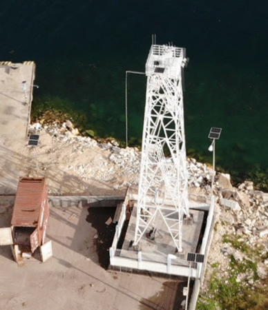
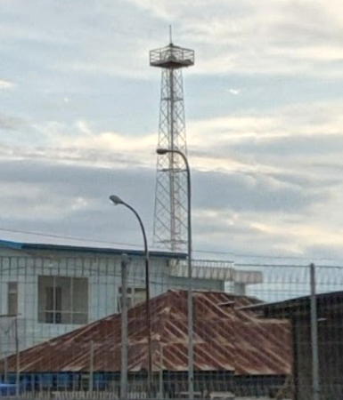
Fakfak Light, Fakfak, March 2020
Google Maps photoby Guntur La Tasmin

West Papua Province South Coast Lighthouses

Kaimana Regency (Kamrau Gulf Area) Lighthouses
Kaimana Regency surrounds the Kamrau Gulf (Teluk Kamrau), a wedge-shaped bay located under the "wattle" of the Doberai (Bird's Head) Peninsula. Kaimana, the regency capital, is a small port on the east side of the Kamrau Gulf.

Pulau Nusurumi
Date unknown. Active; focal plane 57 m (187 ft); white flash every 5 s. Approx. 15 m (49 ft) concrete post with gallery. Entire lighthouse is white. No photo available but Google has a satellite view. Located at the north end of Nusurumi, the largest of an archipelago of limestone islands in the center of the Triton Bay in southernmost West Papua. Accessible only by boat. Site status unknown. Admiralty Q3345.4; NGA 25910.
Bitsyaru
Date unknown. Active; focal plane 75 m (246 ft); three white flashes every 15 s. 15 m (49 ft) iron skeletal tower, painted white. No photo available but Google has a distant satellite view. Located on a promontory at Bitsyaru on the Kamrau Gulf. Site status unknown. ARLHS IDO-113; Admiralty Q3345.3; NGA 25916.
* Kaimana (Teluk Kaimana) (2)
Date unknown. Active; focal plane about 25 m (82 ft); white flash every 10 s. Approx. 23 m (75 ft) square skeletal tower painted white. Part of Ismu Hidayat's 2020 street view is at right, the light is at the right side of Debora Fugida's panoramic view, La Madi has a distant view, and Google has a satellite view. NGA lists a much smaller tower for this location. Located on the waterfront in Kaimana. Site open, tower closed. Admiralty Q3345; NGA 25917.
Tanjung Simora
Date unknown. Active; focal plane 27 m (89 ft); white flash every 3 s. Approx. 20 m (66 ft) square white skeletal tower. No photo available but Google has a satellite view. Located on the promontory on the west side of the entrance to Kaimana Bay. Site status unknown; since this lighthouse is close to a road it may be accessible. Admiralty Q3344.7; NGA 25917.5.
 

Teluk Kaimana Light, Kaimana, February 2020
Google Maps photo by Ismu Hidayat
Pulau Sarlota (Serotte Island)
Date unknown. Active; focal plane 50 m (164 ft); two red flashes every 10 s. Approx. 30 m (98 ft) square skeletal tower, painted white. Untung Pamuji posted a distant 2012 view from the sea (seen at right) and Google has an indistinct satellite view. Located on an island in the upper Kamrau Gulf. Accessible only by boat. Site status unknown. Admiralty Q3344.5; NGA 25918.
Pulau Keliwala (Kiliwala)
Date unknown. Active; focal plane 13 m (43 ft); white flash every 3 s. Approx. 13 m (43 ft) "white beacon," presumably a skeletal tower. No photo available but Google has a satellite view. Located on a small island about 25 km (15 mi) north of Pulau Adi. Accessible only by boat. Site status unknown. Admiralty Q3343.5; NGA 25914.
Pulau Adi
Date unknown. Active; focal plane 30 m (98 ft); three white flashes every 15 s. Approx. 20 m (66 ft) square white skeletal tower. Several 1-story coast guard station buildings. No photo available but Google has a satellite view. This light marks the west side of the entrance to the large Kamrau Gulf on the southwest coast of Papua. Accessible only by boat. Site status unknown. Admiralty Q3345.5; NGA 25912.
Tanjung Nasaulang
Date unknown. Active; focal plane 15 m (49 ft); white flash every 3 s. 15 m (49 ft) post with gallery on a triangular platform supported by piles. No photo available but Bing has an indistinct satellite view. This is an important light marking a major cape at the southern extremity of West Papua. Accessible only by boat. The listed location is about 2 km (1.25 mi) off Cape Nasaulang. Site open, tower closed Admiralty Q3344.

Fakfak Regency Lighthouses
Fakfak is one of the oldest towns in Papua, established in the late 16th century as a trading outpost of the Sultanate of Ternate. The Dutch placed one of their first garrisons in Papua here in 1898. The Fakfak Regency includes the Bomberai Peninsula, separating the Arafura Sea and the Berau Gulf,

Pulau Panjang (Tanjung Wamarusa) (2)
Date unknown (station established 1904). Active; focal plane 34 m (112 ft); three white flashes every 15 s. 13 m (43 ft) (?) square skeletal tower with gallery, painted white. No photo available but Aldy Woretma has the view from atop the tower and Google has a satellite view. This light marks the entrance to a sheltered bay and the small port of Fakfak, on the south side of the Bomberai Peninsula. The lighthouse appears to be taller than the listed height. Located on Tanjung Wamarusa at the eastern end of Pulau Panjang. Accessible only by boat. Site status unknown. ARLHS IDO-232; Admiralty Q3346; NGA 25920.

Pulau Sarlota Light, Kaimana Regency, July 2012
ex-Panoramio photo copyright Untung Pamuji; permission requested
* Fakfak (2?)
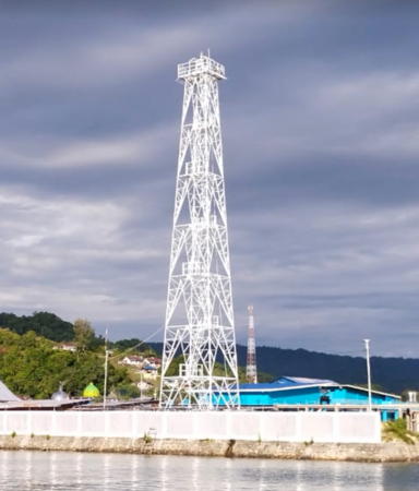
Date unknown. Active; focal plane about 22 m (72 ft); white flash every 3 s. Approx. 20 m (66 ft) square white skeletal tower. Guntur La Tasmin has a 2020 drone view (a portion is shown at the top of this page), Fony Fitriana has a distant view from the sea, and Google has a 2020 street view and a satellite view. NGA describes a beacon with a focal plane of only 12 m (39 ft). Located on the main quay at Fakfak. Site status unknown but the light is easy to see from nearby. Admiralty Q3347; NGA 25924.
Karang Metimeti (Meti Meti)
Date unknown. Active; focal plane 13 m (43 ft); red flash every 4 s. 13 m (43 ft) tower mounted on a platform supported by piles. No photo available but Google has a satellite view. Located at the south end of a reef off the harbor of Fakfak. Accessible only by boat. Site open, tower closed. Admiralty Q3347.5; NGA 25923.
Tanjung Udang (Fakfak ASDP Port)
Date unknown. Active; focal plane 34 m (112 ft); white flash every 10 s. 30 m (98 ft) square pyramidal white skeletal tower. No photo available but Google has a satellite view. Located on the quay of a new ferry terminal about 12 km (7.5 mi) west of Fakfak. Accessible by road from Fakfak. Site open, tower closed. Admiralty Q3347.55.
Pulau Ega (Ekka)
Date unknown. Active; focal plane 50 m (164 ft); two white flashes every 10 s. Approx. 40 m (131 ft) square white skeletal tower. No photo available but Bing has an indistinct satellite view. This is the landfall light for Fakfak. Located at the west end of Pulau Ega, about 40 km (25 mi) west of Fakfak. Accessible only by boat. Site status unknown. Admiralty Q3347.6; NGA 25922.
Pulau Batuputih (Batu Putih)
Date unknown. Active; focal plane 55 m (164 ft); white flashes every 5 s. Listed only as a "white beacon"; Google has a satellite view that appears to show a barbell-shaped fiberglass tower. Located at the west end of Pulau Batu Putih, about 55 km (35 mi) west of Fakfak. Accessible only by boat. Site status unknown. Admiralty Q3347.7; NGA 25925.
Pulau Sabuda
Date unknown. Active; focal plane 100 m (328 ft); two white flashes every 18 s. 17 m (56 ft) square skeletal tower, painted white. No photo available but Bing has a satellite view. Sabuda is an island about 25 km (15 mi) long off the entrance to the Berau Gulf, a large embayment under the "chin" of the Bird's Head. Located at the eastern end of the island. Accessible only by boat; the island is reported to be privately owned. Site status unknown. ARLHS IDO-245; Admiralty Q3348.4; NGA 25940.
Tanjung Wetin
Date unknown. Active; focal plane 31 m (102 ft); white flash every 3 s. Approx. 15 m (49 ft) white fiberglass (?) tower. No photo available but Google has a satellite view. Located on a forested promontory on the north side of the Bomberai Peninsula. Site status unknown. Admiralty Q3348.7; NGA 25938.
* Teluk Kokas (2)
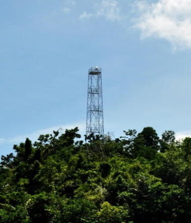
Date unknown. Active; focal plane about 22 m (72 ft); flashing white light (?). Approx. 20 m (66 ft) square skeletal tower painted white. Gustin Siaila's 2022 photo is at right, a second photo is available, and Google has a fuzzy satellite view. NGA lists a 12 m (39 ft) tower for this location. Located on the pier in Kokas, a village on the north side of the Bomberai Peninsula. Site open, tower closed. Admiralty Q3350; NGA 25936.

Teluk Kokas Light, Fakfak Regency, September 2022
Google Maps photo by Gustin Siaila

Teluk Bintuni (Bintuni Gulf) Regency Lighthouses
The Teluk Bintuni Regency surrounds Bintuni Bay, the narrower eastern extension of the Berau Gulf.

Tanjung Tanahmerah (LNG Tengguh) (2?)
Date unknown. Active; focal plane 50 m (164 ft); three white flashes every 15 s. Approx. 30 m (98 ft) square skeletal tower. Bagus Martada has a photo, Marsuki Barru has a photo, and the tower casts a conspicuous shadow in Bing's satellite view. The light is listed by NGA as a 10 m (33 ft) white skeletal tower. Located in the LNG Tengguh natural gas terminal on the upper south side of Bintuni Bay. Site status unknown. Admiralty Q3354; NGA 25932.
Tanjung Karakra
Date unknown. Active; focal plane 13 m (43 ft); white flash every 3 s. Approx. 13 m (43 ft) white fiberglass (?) tower. No photo available but Bing has a satellite view. Located on or just off a low promontory on the north side of the Bintuni Gulf, a large embayment under the "chin" of the Bird's Head. Site status unknown. Admiralty Q3352; NGA 25930.

Southwest Papua Province South Coast Lighthouses

Sorong Selatan (South Sorong) Regency Lighthouses
Tanjung Sabra (2)
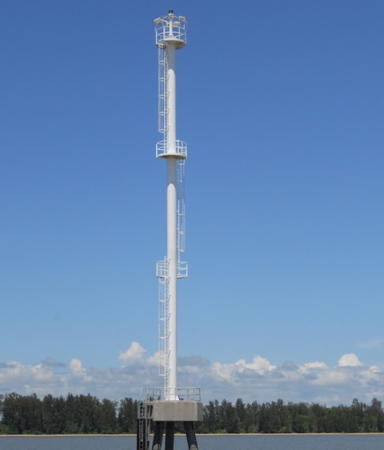
2008 (station establishment date unknown). Active; focal plane 36 m (118 ft); white flash every 5 s. 30 m (98 ft) robust steel pole with three galleries, painted white, mounted on a triangular concrete platform supported by piles. Eddy Manibuy has a closeup photo (also seen at right) and Bing has a good satellite view. Located just off a low promontory on the north side of the entrance to the Berau Gulf. Accessible only by boat. Site status unknown. ARLHS IDO-327; Admiralty Q3349; NGA 25928.
Tanjung Putus
Date unknown. Active; focal plane 14 m (46 ft); white flash every 3 s. Approx. 12 m (39 ft) white tower. No photo available but Google has a distant satellite view. Located on a swampy point about 25 km (15 mi) northwest of Tanjung Sabra. Accessible only by boat. Site status unknown. Admiralty Q3356; NGA 25926.
Tanjung Bakoi
Date unknown. Active; focal plane 14 m (46 ft); white flash every 3 s. 14 m (46 ft) barbell-shaped white fiberglass tower mounted on a platform supported by piles. No photo available and the light is not shown in Google's satellite view. The light marks the approach to the Waronge estuary. Located at the end of a long shoal on the south side of the approach, about 16 km (10 mi) southwest of the entrance. Accessible only by boat. Site status unknown. Admiralty Q3357.
Teminabuan (Wersmer Teminabuan Port)
Date unknown. Active; focal plane 35 m (115 ft); white flash every 10 s. 30 m (98 ft) square pyramidal white skeletal tower. Moto Jelajah has a 2024 view from the pier and Google has a satellite view. The village of Teminabuan is the seat of South Sorong Regency. Located on the waterfront of the village's small port, on the Waronge estuary about 40 km (25 mi) from the open sea. Site open, tower closed. Admiralty Q3356.8.

Sorong Regency: South Coast Lighthouses
Pulau Yefyus (Yef Yus, Jef Joes)
Date unknown. Active; focal plane 33 m (108 ft); white flash every 7.5 s. 20 m (66 ft) square skeletal tower with gallery, painted white. Three 1-story station buildings. No photo available but Bing has a satellite view of the station. Located on a tiny, isolated island in the Seram Sea about 40 km (25 ft) south of the "beak" of the Bird's Head. Accessible only by boat. Site status unknown. ARLHS IDO-136; Admiralty Q3358; NGA 25944.

Tanjung Sabra Light, Berau Gulf, November 2010
Google Maps photo by Eddy Manibuy
Pulau Umpe
Date unknown. Active; focal plane 11 m (36 ft); white flash every 5 s. 10 m (33 ft) square white skeletal tower. No photo available and the light is not seen in Bing's satellite view of the listed location.. Located at or just off the west end of a small island about 10 km (6 mi) southeast of the entrance to the Sele Strait leading to regency capital, Sorong. Accessible only by boat. Site status unknown. Admiralty Q3360; NGA 25948.
Tanjung Sele
Date unknown. Active; focal plane 13 m (43 ft); green flash every 5 s. 13 m (43 ft) green beacon, probably a square green skeletal tower, on a platform supported by piles. No photo available and the light is not shown in Google's satellite view. Located on a reef on the east side of the southern entrance to the Sele Strait. Accessible only by boat. Admiralty Q3387.5; NGA 26017.
Pulau Membok
Date unknown. Active; focal plane 14 m (46 ft); red flash every 10 s. 14 m (46 ft) square red skeletal tower mounted on a platform supported by piles. No photo available but Bing has a satellite view. Located on a reef on the west side of the southern entrance to the Sele Strait. Accessible only by boat. Admiralty Q3386; NGA 26016.

Raja Ampat Regency: Pulau Misool Area Lighthouse
The Raja Ampat Islands are a loose group of islands, large and small, lying off the western tip of Papua. The name means "Four Kings," and there are four large islands: Misool in the south, Salawati and Batanta in the center just off the Papuan coast, and Waigeo to the north. Pulau Misool is a large but sparsely populated island, about 130 km (80 mi) long and up to 55 km (35 mi) wide.

Pulau Nampale
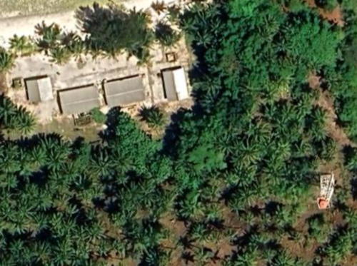
Date unknown. Active; focal plane 46 m (151 ft); three white flashes every 20 s. Approx. 30 m (98 ft) square white skeletal tower. Four 1-story coast guard station buildings. No photo available but Google has the satellite view seen at right. Located on the northeast tip of Pulau Nampale, an island off the west end of Pulau Misool. Accessible only by boat. Site status unknown. Admiralty Q3357.5; NGA 25948.5.

Pulau Nampale Light Station, Raja Ampat Islands
Google Maps satellite view

Raja Ampat Regency: Salawati and Batanta Area Lighthouses
Pulau Boo Besar
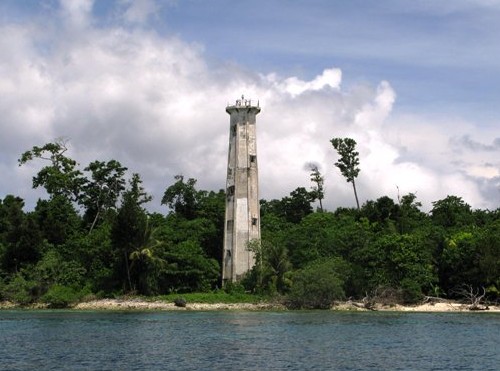
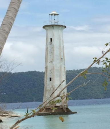
Date unknown. Active; focal plane 34 m (112 ft); two white flashes every 10 s. 30 m (98 ft) octagonal white concrete tower with gallery; lantern removed. A photo is at right and Google has a satellite view. This light marks an important passage between the Halmahera and Seram Seas. The Royal Australian Navy has an article mentioning that its ships Hawkesbury and Cape Leeuwin established (or re-established) this light in July 1945 to reopen the shipping lane through the East Indies. Boo Besar is a small island at the extreme western end of the Boo Islands, a group about 65 km (40 mi) north of Pulau Misool. Located in the Halmahera Sea about 160 km (100 mi) northeast of Obi and about 200 km (125 mi) west of the western tip of Papua (New Guinea). Accessible only by boat. Site status unknown. ARLHS IDO-193; Admiralty Q1603.5; NGA 25948.7.
Pulau Kofiau (Tanjung Soos)
Date unknown. Active; focal plane 46 m (151 ft); white flash every 5 s. 45 m (148 ft) square skeletal tower with lantern and gallery, painted white; lantern painted red. Four 1-story coast guard station buildings. A 2010 photo is available and Bing has a satellite view of the station. Located at the eastern end of Pulau Kofiau, which is also the eastern end of the Boo Islands. Accessible only by boat. Site status unknown. Admiralty Q3361; NGA 25949.
Pulau Ifmun (2?)
Date unknown. Active; focal plane 33 m (108 ft) (?); white flash every 7.5 s. Approx. 18 m (59 ft) square skeletal tower, painted white and mounted on a square platform supported by piles. No photo available but Google has a satellite view. The tower appears to have replaced a similar tower placed at the edge of the land. Until 2014 NGA listed a light at or near this location as "Kepulauan Kabu, Ifmoen," but that listing has been dropped. Located at the west end of a small island just off the westernmost tip of Pulau Salawati. Accessible only by boat. Site open, tower closed. Admiralty Q3361.5; ex-NGA 26018.
Pulau Boo Besar Light
Pulau Boo Besar Light, Raja Ampat Islands, July 2009
ex-Panoramio photo copyright muhajir3012; used by permission
Selat Sagawin (Sagawin Strait, Pulau Batanta)
Date unknown. Active; focal plane 115 m (377 ft); two white flashes every 10 s. 10 m (33 ft) square skeletal tower, painted white, rising from a square station building. No photo available but Bing has a satellite view. Located on the south side of Pulau Batanta, marking the western entrance to the Sagawin Strait separating Salawati and Batanta. Accessible only by boat. Admiralty Q3363.5; NGA 26020.
Tanjung Warangket (2)
2007 (station establishment date unknown). Active; focal plane 74 m (243 ft); two white flashes every 10 s. Square skeletal tower with gallery, height unknown but at least 20 m (66 ft). A photo is at right and Google has a satellite view. Located on a promontory on the north coast of Pulau Salawati, marking the narrowest passage of the Sagawin Strait separating Salawati and Batanta. Accessible only by boat. Site status unknown. Admiralty Q3364.

Raja Ampat Regency: Weigeo Area Lighthouses
Pulau Agusta
Date unknown. Active (?); focal plane 22.5 m (74 ft); white flash every 5 s. 23 m (75 ft) octagonal white concrete tower with gallery. This light appears to be abandoned. Franco Di Nardo has the 2014 photo below right, Alberto Tudech has a partial 2019 street view, and Google has a satellite view. Located just off the east coast of a small island at the western end of the Dampier Strait separating Weigeo from Batanta. Accessible only by boat. Site status unknown. ARLHS IDO-189; Admiralty Q3362.5; NGA 26021.
Saonek Besar
Date unknown. Active; focal plane 62 m (203 ft); white flash every 7.5 s. Approx. 30 m (98 ft) square skeletal communications tower with gallery, painted white. Staffed station. Richard Monny has a photo and Google has a satellite view. Saonek Besar is a small but densely populated island about 5 km (3 mi) southwest of Waisai, a port on the south coast of Waigeo. The island is known as a base for scuba diving expeditions. Located atop a bluff on the southern tip of Saonek Besar. Site status unknown. Admiralty Q3363; NGA 26022.
Saonek Mondei
Date unknown. Active; focal plane about 14 m (46 ft); red light, pattern unknown. Approx. 14 m (46 ft) square skeletal tower painted red and mounted on a square platform supported by piles. No photo available but Google has a satellite view. Located just off the southeast coast of a small island about 3 km (1.8 mi) northeast of Saonek Basar. Accessible only by boat. Site open, tower closed. Admiralty Q3363.1.
Karang Waisai (Waisai Reef)
Date unknown. Active; focal plane about 14 m (46 ft), green light, pattern unknown. Approx. 14 m (46 ft) square green skeletal tower on a platform supported by piles. No photo available but Bing has a satellite view. Located at the west end of a long reef parallel to the south coast of Waigao, about 4 km (2.5 mi) southeast of Pulau Saonek. Accessible only by boat. Site open, tower closed. Admiralty Q3363.45.
* [Pelabuhan 300 Waisai]
Date unknown. Active; focal plane about 16 m (52 ft); white light, pattern unknown. Approx. 14 m (46 ft) white mast. Abdul Aziz has a photo and Google has a distant satellite view. Located at the base of the pier at a anewer ferry terminal about 20 km (13 mi) east of the traditional Waisai harbor. Site open, tower closed. Not listed by the Admiralty.
Waisai Entrance
Date unknown. Active; focal plane about 16 m (52 ft); green light, pattern unknown. Approx. 16 m (52 ft) square skeletal tower painted green and mounted on a square platform supported by piles. Gunawan Saputra has a distant view from the Waisai waterfront, Ismu Hidayat has a distant street view, and Google has an indistinct satellite view. Located on a shoal on the east side of the entrance to Waisai, the capital of Raja Ampat Regency, on the south side of Waigeo. Accessible only by boat. Site open, tower closed. Admiralty Q3363.4.
Pelabuhan Waisai
Date unknown. Active; focal plane about 10 m (33 ft); red light, pattern unknown. Approx. 10 m (33 ft) square wood skeletal tower. Ismu Hidayat has a street view from the Waisai waterfront and Google has a satellite view. Located on a shoal opposite the quay at Waisai. Accessible only by boat but easy to see from the dock. Site open, tower closed. Admiralty Q3363.3.
Teluk Kabarei West
Date unknown. Active; focal plane about 13 m (43 ft); green light, pattern unknown. Approx. 13 m (43 ft) square green skeletal tower on a platform supported by piles. Google has a very distant street view and Bing has an indistinct satellite view. Located on a shoal on the west side of the entrance to Kabarei Bay, a harbor on the north coast of Waigeo. Accessible only by boat. Site open, tower closed. Admiralty Q3363.2.
Kabarei
Date unknown. Active; focal plane about 25 m (82 ft); white light, pattern unknown. Approx. 23 m (75 ft) square white skeletal tower. Google has a street view and a satellite view. Located on the waterfront at Kabarei. Site open, tower closed. Not listed by the Admiralty.


Tanjung Warangket Light, Pulau Salawati, January 2010
ex-Panoramio photo copyright muhajir3012; used by permission


Pulau Agusta Light, Sorong Regency, October 2014
Google Maps photo by Franco Di Nardo

Teluk Kabarei East
Date unknown. Active; focal plane about 13 m (43 ft); red light, pattern unknown. Approx. 13 m (43 ft) square red skeletal tower on a platform supported by piles. No photo available but Bing has an indistinct satellite view. Located on a shoal on the west side of the entrance to Kabarei Bay, a harbor on the north coast of Waigeo. Accessible only by boat. Site open, tower closed. Admiralty Q3363.25.

Raja Ampat Regency: Asia and Ayu Islands Lighthouses
The three Asia Islands are north of the Equator and about 117 km (73 mi) north of the island of Weigeo. Also north of the Equator, the two atolls of the Ayu Islands lie halfway between the Asia Islands and Weigeo.

Pulau Fani
Date unknown. Active; focal plane 15 m (49 ft); two white flashes every 10 s. "White beacon"; the tower height is unknown but as the island is quite flat the tower is probably about 15 m (49 ft) in height. No photo available but Google has an indistinct satellite view of this beacon. This light marks the northern end of the Asia islands (Kepulauan Asia), NGA has placed the light erroneously under Palau in Publication 111. Accessible only by boat. Site status unknown. Admiralty F2112; NGA 111-10933.
Pelabuhan Fani
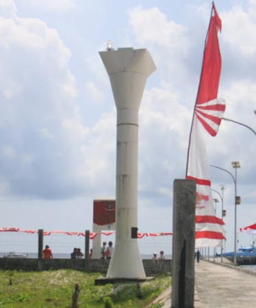
Date unknown. Active; focal plane about 10 m (33 ft); white light, pattern unknown. Approx. 8 m (26 ft) round white barbell-shaped tower. Iksan Mahar's 2019 photo is at right, a 2022 photo is available, and Google has a satellite view. Located at the coast guard station on the southern tip of Pulau Fani. Accessible only by boat. Site status unknown. Not listed by the Admiralty.
Pulau Budd
Date unknown. Active; focal plane 35 m (115 ft); two white flashes every 10 s. Approx. 30 m (98 ft) square white skeletal tower. No photo available but Bing has an indistinct satellite view. Located on a small island west of the main Ayu group. Accessible only by boat. Site status unknown. Admiralty F2113.

Pelabuhan Fani Light, Asia Islands, December 2019
Google Maps photo by Iksan Mahar

Information available on lost lighthouses:

Notable faux lighthouses:

Adjoining pages: Southeast: Southern Papua | South: Southeastern Maluku | West: Central Maluku | Northwest: Northwestern Papua

Return to the Lighthouse Directory index | Ratings key

Posted December 31, 2008. Checked and revised February 3, 2025. Lighthouses: 45. Site copyright 2025 Russ Rowlett and the University of North Carolina at Chapel Hill.