Lighthouses of Japan: Amami Islands

The nation of Japan, known in Japanese as Nihon or Nippon (日本), occupies an archipelago off the east coast of Asia. The four main islands are Hokkaidō in the north, Honshū (the largest), Shikoku in the south, and Kyūshū in the southwest. The country includes thousands of other islands of all sizes; among them the Ryūkyū (Nansei) Islands are a long chain extending to the southwest and including the large island of Okinawa, and the Nanpō Islands are another long chain extending south into the Pacific Ocean. Much of Japan is mountainous but the coastal regions are densely populated and urbanized; the country's population is about 126 million.

The Amami Islands lie to the northeast of Okinawa in the Nansei Islands (Nansei-shotō or "southwest islands" in Japanese), the archipelago extending southwestward from Kyūshū towards Taiwan. Amami Ōshima, the largest island of the group and second largest of the Nansei Islands, is accessible by air, and the other inhabited islands can be reached by ferry from Amami Ōshima. The islands are administered as part of Kagoshima Prefecture, the southernmost prefecture of Kyūshū.

The Amami islands became part of the Ryūkyū Kingdom in the mid 15th century but after 1613 they were governed by Japan. Japan formally annexed the Ryūkyū Islands in 1879 over Chinese protests; U.S. President Ulysses Grant, called in as arbitrator, ruled in favor of Japan. At the end of World War II in 1945 the Amami Islands were governed by U.S. authorities until they were returned to Japan in 1953.

In Japanese the word for a lighthouse is tōdai or toudai (灯台). The words saki and misaki are for capes and headlands, hana ("nose") is a promontory, hantō is a peninsula, shima (also spelled sima or jima) is an island, bae is a reef, iwa or shi is a rocky reef, amase or se is a shoal, wan is a bay, nada is a sound or basin, kaikyō is a strait, kawa is a river, and or minato is a harbor.

Lighthouses in Japan are operated and maintained by the Japanese Coast Guard's Maritime Safety Agency. Lighthouses in the Amami islands are maintained by the office at Amami City.

ARLHS numbers are from the ARLHS World List of Lights. JCG numbers are the Japanese Coast Guard's light list numbers. Admiralty numbers are from volume M of the Admiralty List of Lights & Fog Signals. U.S. NGA List numbers are from Publication 112.

General Sources
Lighthouses in Japan - Kagoshima
This site has data and photos for nearly all of Japan's major lighthouses.
Form of a Lighthouse - Kagoshima
Another site with many photos of Japanese lighthouses, cited below as FOAL.
Lighthouse Visits - 6500-6999
This site has photos for many lighthouses in this area.
Amami District Lighthouses
The Amami Coast Guard Station has pages of photos for Amami Ōshima and for the other islands of the district. Many of the photos on this page are from an earlier photo collection that is no longer online.
Region Ten Lighthouses
Information and photos posted by the Tenth Coast Guard Region office, which is responsible for Kagoshima Prefecture.
Online List of Lights - Japan
Photos by various photographers posted by Alexander Trabas.
Navionics Charts
Navigation chart for the islands.

Tonbi Saki Light
Tonbi Saki Light, Kikai
Japanese Coast Guard Amami Office photo (no longer online)

Kikai Shima Lighthouses

Kikai Town Lighthouses
Kikai Shima (usually spelled Kikaijima) ia an island about 25 km (15 mi) east of Amami Ōshima. It is a raised coral island rather than a volcanic island, making it relatively flat. The population is about 7600 and the island is accessible by ferry.
* Tonbi Saki (Kikaishima)
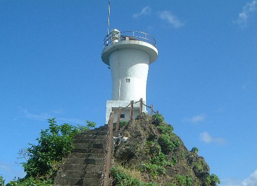
1971. Active; focal plane 41 m (135 ft); white flash every 5 s. 17 m (56 ft) round cylindrical concrete tower with lantern and gallery, attached to a 1-story concrete equipment room. Entire lighthouse is white. The Coast Guard has a closeup and the photo at the top of this page, another page has excellent photos, Lighthouse Visits has a page with excellent photos, FOAL's page also has good photos, Google has a street view, and Bing has a satellite view. Located at the northeastern tip of Kikaishima, an island to the east of Amami Ōshima. Accessible by road from Kikai, the principal settlement on the island. Site open, tower closed. . ARLHS JPN-671; JCG-6932; Admiralty M4782; NGA 13112.
Sōmachi (Somati) Gyoko
1995. Active; focal plane 19 m (62 ft); red flash every 5 s. 13 m (43 ft) round concrete tower with a flared top, attached to a small equipment shelter. Entire lighthouse is red. The Coast Guard has a closeup photo, Lighthouse Visits has a page with good photos, FOAL's page has photos, and Google has a distant street view across the harbor, and Bing has a satellite view. Located at the end of the north breakwater at Sōmachi, on the east coast of Kikaishima. Site status unknown. JCG-6932.5; Admiralty M4782.2; NGA 13114.
Shitsuru (Situru) Saki
1975. Active; focal plane 50 m (164 ft); white light, 3 s on, 3 s off. 13 m (43 ft) round cylindrical concrete tower with lantern and gallery, attached to a 1-story concrete equipment room. Entire lighthouse is white. FOAL has a good page for this lighthouse, Lighthouse Visits has a good page, another page for the lighthouse has good photos and Google has a satellite view. Located on a bluff above the southwestern tip of Kikaishima. Probably accessible by road from Kikai, the principal settlement on the island. Site open, tower closed. . ARLHS JPN-589; JCG-6933; Admiralty M4782.4; NGA 13116.
Wan Kō
1999. Active; focal plane 18 m (59 ft); green flash every 4 s. 12 m (39 ft) round concrete tower with a flared top. Entire lighthouse is white. The Coast Guard has a closeup photo, the Lighthouse Visits page also has a closeup, and Google has a satellite view and a distant street view across the harbor. Located on the detached east breakwater of Wan Kō, the terminal for ferries arriving from Amami Ōshima. Accessible only by boat. Site status unknown. ARLHS JPN-2593; JCG-6936.1; Admiralty M4782.61; NGA 13120.

Shitsuru Saki Light, Kikai
Japanese Coast Guard Amami Office photo

Amami Ōshima Lighthouses

Setouchi Town Lighthouses
Kaitsu (Kaitu) Saki
1959. Active; focal plane 103 m (338 ft); white flash every 3 s. 8 m (26 ft) round concrete tower. Entire lighthouse is white. The Coast Guard has a closeup photo and Google has a satellite view. Located on a very steep promontory at the southeastern tip of Amami Ōshima, marking the eastern entrance to the narrow channel between Amami Ōshima and the smaller island of Kakeroma Shima. Site status unknown. ARLHS JPN-2564; JCG-6955; Admiralty M4781; NGA 13192.
Machiami Saki
1988. Active; focal plane 18 m (59 ft); white flash every 3 s. 9 m (30 ft) hexagonal post rising from a 1-story hexagonal concrete equipment room. Entire lighthouse is white. The Coast Guard has a closeup photo, Lighthouse Visits has a page for the lighthouse, FOAL's page has several distant views, and Google has a fuzzy satellite view. Located on the tip of a promontory at the northeastern corner of Kakeroma Shima. Accessible only by boat. Site open, tower closed. ARLHS JPN-2571; JCG-6954; Admiralty M4781.5; NGA 13188.
* Seto Saki (Amami Seto Saki)
1971. Active; focal plane 40 m (131 ft); two white flashes every 6 s. 9.5 m (31 ft) concrete post attached to a 1-story square concrete equipment room. Entire lighthouse is white. FOAL's page has good photos, the Coast Guard has a page with a photo and also a closeup photo, a 2021 photo is available, and Google has a good street view and a distant satellite view. Located on a promontory a short distance west of Setouchi, on the south coast of Amami Ōshima. Accessible by road although the entrance to the lighthouse is not marked. Site open, tower closed. . ARLHS JPN-018; JCG-6952; Admiralty M4780.6; NGA 13180.
Onen Saki
1961. Active; focal plane 35 m (118 ft); white flash every 5 s. 9 m (30 ft) concrete post centered on a 1-story concrete equipment room. Entire lighthouse is white. The Coast Guard has a closeup photo and Google has a distant satellite view. Located on a very steep promontory in a wild area east of Nishikomi on the south coast of Amami Ōshima. Accessible only by boat. Site and tower closed. ARLHS JPN-2582; JCG-6951; Admiralty M4780.5; NGA 13176.
* Sotsukō (Sotuko) Saki (2)
1988 (station established 1896). Active; focal plane 139 m (456 ft); white flash every 15 s. 16 m (52 ft) round cylindrical concrete tower with lantern and gallery, attached to a 1-story concrete equipment building. Entire lighthouse is white. The Coast Guard has the photo at right, a page for the lighthouse, and a second closeup, Kazuto Yanagisawa has a 2021 closeup, the Lighthouse Visits page has several good photos, FOAL has a good page for the lighthouse, Jun Nishimura has a 2015 photo, and Google has a satellite view. This is one of a chain of light stations built to light the route from Japan to Taiwan after that island came under Japanese administration. Located high on a bluff at the southwestern tip of Amami Ōshima. Accessible by road and a hiking trail; local guidance may be needed. Site open, tower closed. . ARLHS JPN-595; JCG-6950; Admiralty M4780; NGA 13172.
Sotsuko Saki Light
Sotsukō Saki Light, Setouchi
Japanese Coast Guard photo (no longer online)

Yamato Town Lighthouse
* Ōyama Saki
1976. Active; focal plane 190 m (623 ft); white flash every 5 s. 10 m (33 ft) round cylindrical concrete tower. Entire lighthouse is white. A 2017 photo and a 2022 photo are available, Lighthouse Visits has a page for the lighthouse, FOAL's page has good photos, and Google has a distant satellite view. Located in Mineyama Park on a very steep promontory on the central west coast of Amami Ōshima, about 4 km (2.5 mi) west of the village of Yamato. The light can be seen from a popular nearby overlook, and a short hiking trail leads to the lighthouse. The park entrance is well marked. Site open, tower closed. ARLHS JPN-472; JCG-6949; Admiralty M4778; NGA 13168.

Amami City: Naze District Lighthouses
The city of Amami was formed in 2006 by merging the former city of Naze and the town of Kasari. However, the two districts do not border each other; they are separated by the town of Tatsugō.
Tachigami (Tategami, Naze)
1937. Inactive since 2019. 9 m (30 ft) round cylindrical concrete tower with lantern and gallery, attached to a 1-story concrete equipment room. Entire lighthouse is white. The Coast Guard has the photo at right and another closeup, FOAL has photos (top of the page), and Google has an indistinct satellite view. The light was deactivated in favor of the Outer Breakwater Light (next entry), which inherited its JCG and Admiralty numbers. Located on a steep-sided rock in the entrance to Naze harbor. Accessible only by boat. Site open, tower closed. ARLHS JPN-2589; ex-JCG-6941; ex-Admiralty M4770; NGA 13148.
Naze Outer Breakwater
2019. Active; focal plane about 17 m (56 ft); red flash every 3 s. 10 m (33 ft) round concrete tower with a flared top attached to a small equipment cabinet. Entire lighthouse is red. FOAL has February 2019 photos (third row on the page) of the new lighthouse, Lighthouse Visits has a page with photos, and Google has a satellite view. Located at the east end of the detached breakwater sheltering Naze harbor. Accessible only by boat. Site open, tower closed. JCG-6941; Admiralty M4770; NGA 13148.5.
#Naze Kō (West Breakwater) (1)
1989. Destroyed by Typhoon Trami in September 2018. This was a 11 m (36 ft) round cylindrical concrete tower. Entire lighthouse was red. The Coast Guard has a photo, the light is at the far left in a 2016 distant view of the harbor, and Google has a distant street view and an indistinct satellite view. The light was replaced by a tiny temporary light (FOAL has photos helfway down the page) and then by a light on a much smaller tower in January 2020. Lighthouse Visits has a December 2020 photo of the current light. Located on the west breakwater at the entrance to Naze harbor. Site status unknown. ARLHS JPN-2577. Active light: JCG-6941.8; Admiralty M4771; NGA 13150.
Tachigame Light
Tachigami Light, Amami City
Japanese Coast Guard Amami Office photo (no longer online)
#Naze Kō No. 1 Breakwater
Date unknown. Demolished. This was a 10 m (33 ft) concrete post attached to a square 1-story concrete equipment room. Entire lighthouse was red. Google's satellite view shows that this breakwater has been replaced; a post light was placed at the end of the new breakwater, but that light was deactivated in 2015. Formerly located at the end of the breakwater of Naze's traditional harbor. Site status unknown. ARLHS JPN-2576; ex-JCG-6946; ex-Admiralty M4775; ex-NGA 13152.
Naze Kō East Breakwater
1997. Active; focal plane 13 m (43 ft); green light, 3 s on, 3 s off. 11 m (36 ft) round cylindrical concrete tower with gallery. Entire lighthouse is white. The Coast Guard has a closeup photo, FOAL has several photos (rows 4 through 6 on the page), Lighthouse Visits has a photo (last lighthouse on the page), the light is at the left in a distant view of the harbor, Google has a distant street view, and Bing has a satellite view. Located on the east breakwater at the entrance to Naze harbor. Site status unknown. ARLHS JPN-2575; JCG-6942; Admiralty M4771.5; NGA 13151.
* Borose Saki (2)
1966 (station established 1912). Active; focal plane 110 m (361 ft); one long white flash every 10 s. 11 m (36 ft) square pyramidal concrete tower, attached to a small 1-story concrete equipment room. Entire lighthouse is white. The Coast Guard has a page for the lighthouse and a closeup photo, FOAL's page has good photos, a 2021 photo is available, and Google has the street view at right and an indistinct satellite view. The station serves as the landfall light for Naze, the principal town of Amami Ōshima. Located on a promontory about 8 km (5 mi) north of Naze. Accessible by road and short hike; local guidance may be needed. Site open, tower closed. ARLHS JPN-049; JCG-6940; Admiralty M4768; NGA 13144.

Borose Saki Light, Amami City, January 2018
Google Maps street view by nansei

Tatsugō Town Lighthouses
Imai Saki
1975. Active; focal plane 63 m (207 ft); two white flashes every 7 s. 10 m (33 ft) round cylindrical concrete tower with gallery. Entire lighthouse is white. The Coast Guard has a page for the lighthouse and a closeup photo, FOAL has a good page with photos, the Lighthouse Visits page has several photos, Osamu Kidera has a photo, Jun Nishimura has a 2017 photo, a 2018 photo is available, and Google has a satellite view. The lighthouse marks the entrance to Kasari Bay, a sheltered harbor on the north coast of Amami Ōshima. Located on a promontory at the west side of the bay entrance, about 16 km (10 mi) northeast of Naze. This a remote location; local guidance would be needed to find it. Site open, tower closed. . ARLHS JPN-163; JCG-6939; Admiralty M4767.6; NGA 13140.
* Tatsugō Wan
1974. Reactivated; focal plane 16 m (52 ft); continuous white spotlight illuminating a reef 300 m (330 yd) southeast. 11 m (36 ft) post supporting a round lantern room. Entire lighthouse is white. The Coast Guard has a closeup photo, FOAL's page has a 2019 photo, Lighthouse Visits has a page with closeup photos, and Google has an indistinct satellite view. The light was dropped by NGA in 2014, but Google's street view shows restoration in progress in November 2013. Located on the west side of Tatsugō Bay ( the westernmost branch of Kasari Bay) about 4 km (2.5 mi) north of Tatsugō Town. Accessible by road. Site open, tower closed. JCG-6938; Admiralty M4767.4; ex-NGA 13136.
* Akagina (Akakina) Kō Range Front
1992. Active; focal plane 13 m (43 ft); continuous yellow light. 12.5 m (41 ft) round cylindrical concrete tower with gallery, topped by a large upward-pointing arrow and attached to a 1-story equipment shelter. The light is shown through an opening in the arrow. Entire lighthouse is white. The Coast Guard has a closeup photo, Lighthouse Visits has a photo of the range lights, FOAL's page has photos, and Google has a street view and an indistinct satellite view. This range guides vessels in the easternmost branch of Kasari Bay. The rear light is on a similar tower 6 m (20 ft) tall. Located on the west shore of the inlet just south of Maehida. Site open, tower closed. JCG-6937.5; Admiralty M4767.8; NGA 13134.

Amami City: Kasari District Lighthouses
The former town of Kasari occupies a narrow peninsula at the northeastern tip of Amami Ōshima.

*
Kasari Saki
1962. Active; focal plane 67 m (220 ft); two white flashes every 30 s. 13 m (43 ft) square cylindrical concrete tower with a semicircular concrete lantern and gallery, attached to a 1-1/2 story concrete equipment and crew building. Entire lighthouse is white. The Coast Guard has the photo at right and a distant view on a page for the lighthouse, the Lighthouse Visits page has excellent photos, FOAL's page has several photos, a 2021 closeup is available, and Google has a street view and a satellite view. Located on a sharp promontory at the extreme northeastern tip of Amami Ōshima. Accessible by road followed by a very steep climb up a very narrow staircase to the lighthouse. Site open, tower closed. . ARLHS JPN-235; JCG-6937; Admiralty M4767; NGA 13132.

Kasari Saki Light, Amami City
Japanese Coast Guard Amami Office photo

Tokuno Shima Lighthouses

Tokuno Shima is an island about 40 km (25 mi) southwest of Amami Ōshima. The island is about 25 km (15 mi) long and up to 18 km (11 mi) wide. Accessible by air and by ferry from Amami Ōshima, Tokuno Shima is well populated, with more than 25,000 permanent residents.

Isen Town Lighthouse
Kinen Saki
1986. Active; focal plane 22 m (72 ft); two white flashes every 7 s. 14 m (46 ft) round concrete tower with lantern and gallery, attached to a 1-story concrete equipment room. Entire lighthouse is white. The Coast Guard's photo is at right, FOAL has an excellent page with many photos, and Google has a distant satellite view. Located in Isen at the southeastern tip of Tokuno Shima, surrounded by farm fields. Site status unknown. ARLHS JPN-2568; JCG-6961; Admiralty M4765.6; NGA 13212.

Amagi Town Lighthouse
* Yonama Saki
1974. Active; focal plane 54 m (177 ft); two white flashes every 10 s. 16 m (52 ft) round concrete tower with lantern and gallery. Entire lighthouse is white. The Coast Guard has a closeup photo, FOAL has an excellent page with many photos, Fumi Konoto has a 2021 closeup, and Google has a street view and a satellite view. Located at the northwestern tip of Tokuno Shima. Accessible by road but the entrance is unmarked. Site open, tower closed. ARLHS JPN-758; JCG-6963; Admiralty M4766; NGA 13220.

Tokunoshima Town Lighthouses
* Kanami Saki (2)
Date unknown (station established 1973). Active; focal plane 43 m (141 ft); white flash every 3 s. 11 m (36 ft) square cylindrical skeletal tower mostly enclosed by a white slatted daymark. A powerful spotlight (JCG-6957) halfway up the tower illuminates a shoal to the north northeast. FOAL's page has closeup photos, Thom Kei has a distant view and Google has a satellite view. The Coast Guard has a closeup photo of the original lighthouse, a square cylindrical concrete tower attached to a square 2-story equipment structure. Located at the northeastern tip of Tokuno Shima. The lighthouse appears to be accessible by a short hike from a paved road. Site probably open, tower closed. ARLHS JPN-225; JCG-6956; Admiralty M4766.5; NGA 13196.
Kinen Saki Light
Kinen Saki Light, Isen
Japanese Coast Guard Amami Office photo (no longer online)
* Kametoku Range Front
1966. Active; focal plane 17 m (56 ft); continuous yellow light. 15 m (49 ft) round white concrete tower attached to a square 1-story concrete equipment building. FOAL has a page with photos of both range lights and Google has a street view and an indistinct satellite view. Located on the waterfront of Kametoku, a port on the southeast side of Tokuno Shima. Site open, tower closed. ARLHS JPN-2565; JCG-6959; Admiralty M4766.8; NGA 13204.
* Kametoku Range Rear
1966. Active; focal plane 22 m (72 ft); continuous yellow light. 15 m (49 ft) round white concrete tower attached to a square 1-story concrete equipment building. The Coast Guard has a closeup photo, FOAL has a page with photos of both range lights, and Google has a street view and an indistinct satellite view. Located 130 m (142 yd) west of the front light. Site open, tower closed. ARLHS JPN-2566; JCG-6960; Admiralty M4766.81; NGA 13208.
Kametoku Kō (South Breakwater)
1981. Active; focal plane 18 m (59 ft); green flash every 4 s. 13 m (43 ft) round concrete tower with gallery. Entire lighthouse is white. The Coast Guard has a photo, FOAL's page has good photos, a 2020 sea view is available, and Google has a satellite view and a distant street view across the harbor. Located at the north end of the detached south breakwater of Kametoku. Accessible only by boat. Site open, tower closed. ARLHS JPN-2567; JCG-6958; Admiralty M4766.7; NGA 13200.

Yonama Saki Light, Amagi
Japanese Coast Guard Amami Office photo

Okinoerabu Shima Lighthouses

Okinoerabu Shima is a small island located about 30 km (19 mi) southwest of Tokuno Shima. Famous in Japan for its lily nurseries, the island has a population of about 15,000 and is accessible by air or by ferry. Flights to the island are available from Kagoshima or Okinawa.

Wadomari Town Lighthouses
* Inobe Kō Range Front
1994. Active; focal plane 23 m (75 ft); continuous yellow light. 16 m (52 ft) round cylindrical concrete tower attached to a small 1-story concrete equipment shelter. The tower has six petal-like projections at the top, so that it resembles a white lily. Entire lighthouse is white. A Coast Guard photo is at right, FOAL's page has many photos, and Google has a street view and a satellite view. The rear light is on a 13 m (43 ft) post seen in a Google street view and a Coast Guard photo. The island is known for its nurseries growing flowers, including lilies in particular. Located on the waterfront of Inobe, on the north coast of Okinoerabu Shima. Site open, tower closed. JCG-6968.5; Admiralty M4765.5; NGA 13242.
* Kunigami (Kuniga) Misaki
1973. Active; focal plane 46 m (151 ft); white flash every 5 s. 20 m (66 ft) round concrete tower with lantern and gallery. Entire lighthouse is white. FOAL's page has good photos, Akihiko Enomoto has a 2020 closeup photo, and Google has a street view and a satellite view. A 2022 photo shows the lighthouse being repainted. Located at the northeastern tip of Okinoerabu Shima, adjacent to the runway of the island's airport. Accessible by road, although no parking is provided. Site open, tower closed. . ARLHS JPN-303; JCG-6964; Admiralty M4765.4; NGA 13224.

China Town Lighthouses
China (Tina) Kō
Date unknown. Active; focal plane 32 m (105 ft); continuous white, red or green light depending on direction. 13 m (43 ft) round cylindrical concrete tower with a box-like lantern structure. Entire lighthouse is white. The Coast Guard has a closeup photo, FOAL's page also has closeup photos, and Google has a street view and a satellite view. Located in a commercial area of the port, at the southwestern tip of the island. Site and tower closed, although the lighthouse can be seen easily from the waterfront. ARLHS JPN-2590; JCG-6967; Admiralty M4765.3; NGA 13236.
Inobe Range Front Light
Inobe Kō Range Front Light, Wadomari
Japanese Coast Guard Amami Office photo (no longer online)
* Yakuniya Saki
1974. Active; focal plane 72 m (236 ft); two white flashes every 7 s. 18 m (59 ft) round cylindrical concrete tower with lantern and gallery attached to a 1-story concrete equipment room. Entire lighthouse is white. FOAL has an excellent page for this lighthouse, the Coast Guard has a page with photos, Masami Harasaki has a 2018 closeup, Yasuhiko Horikawa has a photo, and Google has a good street view and a satellite view. Located at the northwestern tip of Okinoerabu Shima. Accessible by road from Inobe and Wadomari, the principal settlements on the island; parking is available across the road from the lighthouse. Site open, tower closed. . ARLHS JPN-749; JCG-6968; Admiralty M4765.2; NGA 13240.

Yoron Shima Lighthouses

Southernmost of the Amami Islands, Yoron is also the northernmost Japanese island to be fringed by coral reefs. It is only 22 km (13.7 mi) from the northern tip of Okinawa and is sometimes considered to be one of the Okinawa Islands. The island has a population of about 6000 and is accessible by ferry from Okinawa.

Yoron Town Lighthouses
* Aka Saki (Yoron Jima)
1971. Active; focal plane 23 m (75 ft); white flash every 4 s. 13 m (43 ft) round concrete tower. Entire lighthouse is white. The original Fresnel lens is on display at the Southern Cross Center, a museum and observation tower. The Coast Guard has the photo at right and a page with another photo, FOAL has a fine page for the lighthouse, Hirotaka Yamamoto has a 2019 closeup, a 2021 photo is available, Masahiro Daishi has a photo, and Google has a satellite view. Located on the southeastern point of the island. Accessible by road; parking is available at a nearby restaurant. Site open, tower closed. . ARLHS JPN-762; JCG-6969; Admiralty M4763.8; NGA 13244.
* Tomori (Yoron Kō Leading Light)
1989. Active; focal plane 21 m (69 ft); continuous white, red, or green light, depending on direction. 9 m (30 ft) square concrtete tower with an expanded upper section. Entire lighthouse is white. The Coast Guard has a page with photos, FOAL's page has photos, Tomokazu Yasuda has a 2021 photo, and Google has a good street view and a satellite view. This light guides vessels approaching from the south through an opening in the reefs surrounding the island. Located on the south side of the Yoronjima airport. Accessible by road, although no parking is provided. Site open, tower closed. ARLHS JPN-761; JCG-6969.7; Admiralty M4763.9; NGA 13246.
* Yoron Jima (Hanebu Saki, Yoron Kō) (2?)
2000 (station established 1962). Active; focal plane 20 m (66 ft); white or red light, depending on direction, 3 s on, 3 s off. 10 m (33 ft) round concrete tower centered on a round 1-story equipment room. The lighthouse is painted with red and white horizontal bands (unusual for a southern Japanese lighthouse), although it is listed as white by NGA and appears all white in the Lighthouse of Japan photo. FOAL has a fine page with closeup photos showing the red and white bands, the Coast Guard has a page with photos, Aoguro Jirō has a 2018 closeup, the top of the light is seen in a 2016 street view, and Google has a satellite view. Located on a dune on the west side of the entrance to the harbor of Yoron Jima. The light is on the property of a resort hotel but is accessible with permission of the staff. Site open, tower closed. . ARLHS JPN-2562; JCG-6970; Admiralty M4764; NGA 13248.
Aka Saki Light
Aka Saki Light, Yoron
Japanese Coast Guard Amami Office photo (no longer online)

Information available on lost lighthouses:

Notable faux lighthouses:

Adjoining pages: North: Ōsumi Islands | South: Okinawa Islands

Return to the Lighthouse Directory index | Ratings key

Posted August 27, 2007. Checked and revised March 10, 2023. Lighthouses: 33. Site copyright 2023 Russ Rowlett and the University of North Carolina at Chapel Hill.