Lighthouses of Japan: Southern Kōchi

The nation of Japan, known in Japanese as Nihon or Nippon (日本), occupies an archipelago off the east coast of Asia. The four main islands are Hokkaidō in the north, Honshū (the largest), Shikoku in the south, and Kyūshū in the southwest. The country includes thousands of other islands of all sizes; among them the Ryūkyū (Nansei) Islands are a long chain extending to the southwest and including the large island of Okinawa, and the Nanpō Islands are another long chain extending south into the Pacific Ocean. Much of Japan is mountainous but the coastal regions are densely populated and urbanized; the country's population is about 126 million.

Smallest of the Japanese main islands, Shikoku is divided into four prefectures. This page includes lighthouses of the southern portion of Kōchi Prefecture, from Cape Okitsu around Cape Ashizura, the southernmost point of Shikoku. This is a spectacularly rugged and scenic coast.

In Japanese the word for a lighthouse is tōdai or toudai (灯台). The words saki and misaki are for capes and headlands, hana ("nose") is a promontory, hantō is a peninsula, shima (also spelled sima or jima) is an island, bae is a reef, iwa or shi is a rocky reef, amase or se is a shoal, wan is a bay, nada is a sound or basin, kaikyō is a strait, kawa is a river, and or minato is a harbor.

Lighthouses in Japan are operated and maintained by the Japanese Coast Guard's Maritime Safety Agency. There is at least one Coast Guard Section Office in each prefecture, often two or more. Kōchi Prefecture has a single section office at Kōchi city.

ARLHS numbers are from the ARLHS World List of Lights. JCG numbers are the Japanese Coast Guard's light list numbers. Admiralty numbers are from volume M of the Admiralty List of Lights & Fog Signals. U.S. NGA List numbers are from Publication 112.

General Sources
Lighthouses in Japan - Kōchi
This site covers most of the major lighthouses of Japan.
Lighthouse of Japan - Kōchi
Another comprehensive site, in Japanese, with pages for each prefecture.
Form of a Lighthouse - Kōchi
Another site with many photos of Japanese lighthouses, cited below as FOAL.
Lighthouse Visit
Another good source of lighthouse photos.
Online List of Lights - Japan
Photos posted by Alexander Trabas.
Misty's Japanese Lighthouse Tour - Kōchi
Photos and a few notes in English for lighthouses in all parts of the country.
Kōchi Aids to Navigation
Photos and information for six well-known lighthouses posted by the Kōchi Coast Guard Office.
Lighthouses in Kōchi Prefecture
Photos by various photographers available from Wikimedia.
Japan: Modern Lighthouses
Historic postcard views posted by Michel Forand.
Navionics Charts
Navigation chart for Shikoku.


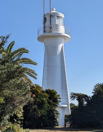
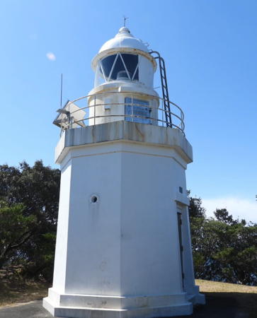
Ashizuri Saki Light, Tosashimizu, January 2024
Google Maps photo by Katunori Tanimoto
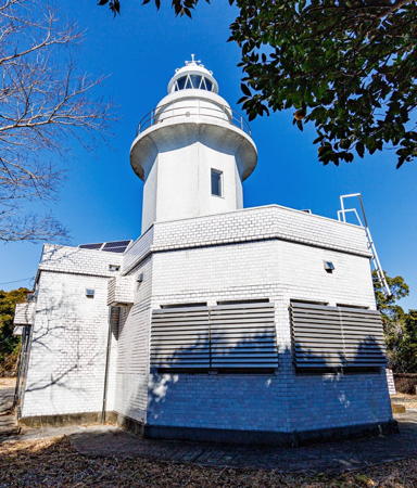
Shimanto Town Lighthouse
Okitsu (Okitu) Saki
1951. Active; focal plane 187 m (614 ft); two white flashes every 15 s. 14 m (46 ft) octagonal cylindrical concrete tower with lantern and gallery, attached to a 1-story concrete equipment building. Entire lighthouse is white. The Coast Guard's photo appears at right, Trabas has a good closeup photo, Lighthouse-Japan.com has a page with good photos, FOAL's page has photos, Lighthouse Visit has photos, a 2020 photo is available, Kazutaka Chosokabe has a street view, and Google has a satellite view. One of Japan's highest lighthouses, this powerful light has a range of 61 km (38 mi). Located on a prominent cape in Shimanto, about 10 km (6 mi) northeast of Saga. Accessible by driving or hiking about 2.5 km (1.5 mi) on the access road; the entrance is unmarked and the FOAL webmaster found the road too scary to drive. Site open, tower closed. . ARLHS JPN-486(=2507); JCG-3079; Admiralty M5598; NGA 10224.

Kuroshio Town Lighthouses
Saga (Tosasaga) Kō Groin
Date unknown. Active; focal plane 20 m (66 ft); two green flashes every 6 s. 12 m (39 ft) round cylindrical concrete tower attached to a square equipment shelter. Entire lighthouse is white. FOAL has two photos (second row left and bottom row left), Trabas has a closeup photo, Lighthouse Visit has a photo (first lighthouse on the page), and Google has a satellite view. Located at the end of a breakwater extending north from Kashima, an island in Saga harbor. Accessible only by boat. Site open, tower closed. ARLHS JPN-2510; JCG-3081; Admiralty M5598.3; NGA 10228.
Saga (Tosasaga) Kō Outer Breakwater
Date unknown. Active; focal plane 19 m (62 ft); green flash every 3 s. 13 m (43 ft) round tapered concrete tower attached to a small equipment shelter. Entire lighthouse is white. Trabas has a photo, FOAL has two photos (next to last row and bottom row right), Lighthouse Visit has a photo (second lighthouse on the page), and Google has a satellite view. Located on a detached breakwater at the south entrance to Saga harbor. Accessible only by boat. Site open, tower closed. ARLHS JPN-2511; JCG-3083.2; Admiralty M5598.25; NGA 10234.
Ino (Inomino) Misaki
1959. Active; focal plane 45 m (148 ft); two white flashes every 8 s. 10.5 m (35 ft) round vase-shaped concrete tower with gallery. Entire lighthouse is white. Lighthouse-Japan has a page with photos, FOAL's page has photos, Lighthouse Visit also has a page, Misty's Tour has additional photos, Trabas has a photo, there's a drone view, and Google has a satellite view. Located on a prominent cape about 10 km (6 mi) south of Saga. Several visitors have found it impossible to reach this site through dense undergrowth, although the lighthouse can be seen from nearby. ARLHS JPN-169; JCG-3084; Admiralty M5598.5; NGA 10252.

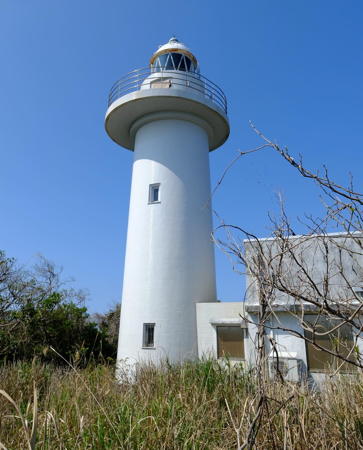
Okitsu Saki Light, Shimanto, January 2024
Instagram photo by ちゑ臧
* Ida Kō
Date unknown. Active; focal plane 11 m (36 ft); green flash every 4 s; in addition, a spotlight (JCG-3086) illuminates a reef off the harbor entrance. 9.5 m (31 ft) round cylindrical concrete tower. Entire lighthouse is white. Lighthouse Visit has a page with photos, Trabas has a closeup photo, and Google has a street view and a satellite view. Located on the north breakwater of Ida harbor, in the lee of Ino Misaki. Accessible by walking the pier. Site open, tower closed. ARLHS JPN-2489; JCG-3085; Admiralty M5598.7; NGA 10256.
#Kamikawaguchi (Kami Kawaguti) Kō
Date unknown. Inactive since 2007 and since removed. This was an 8.5 m (28 ft) concrete post with gallery, mounted atop a square 1-story concrete equipment room. Entire lighthouse was white. No light is seen in Google's satellite view. This light was not dropped from the NGA List until 2015 but the FOAL webmaster could not find it in April 2013. Located at Kamikawaguchi, a port about 5 km (3 mi) northwest of Ino Misaki. Site status unknown. ARLHS JPN-214; ex-JCG-3087; ex-Admiralty M5599; ex-NGA 10236.
#Kamikawaguchi (Kami Kawaguti) Kō North Breakwater
Date unknown. Inactive since 2007 and since removed. This was a 9.5 m (31 ft) concrete post attached to a square 1-story concrete equipment room. Entire lighthouse was white. Google's satellite view confirms that the light has been removed. It became redundant when a detached breakwater was built outside the original harbor entrance. Formerly located on the north (really west) breakwater of Kamikawaguchi. Site open. ARLHS JPN-2490; ex-JCG-3088; ex-Admiralty M5599.2; ex-NGA 10240.
Kamikawaguchi (Kami Kawaguti) Kō Detached Breakwater
2007. Active; focal plane about 12 m (39 ft); red light, characteristic unknown. Approx. 10 m (33 ft) round concrete tower with a flared top attached to a small equipment shelter. Lighthouse Visit also has a page for the lighthouse, Trabas has a closeup photo, and Google has a satellite view and a very distant street view. Located on the detached breakwater protecting the entrance to Kamikawaguchi. Accessible only by boat. Site open, tower closed. JCG-3087; Admiralty M5599.25.
Irino Kō (1)
Date unknown. Inactive. Approx. 11 m (36 ft) round concrete tower with a flared top. The deactivated lighthouse was painted black; a series of light and dark blue horizontal bands have been added. Google has a satellite view and a distant street view. Trabas has a photo and Lighthouse Visit has a page for the replacement light (focal plane 15 m (49 ft); green flash every 3 s), a post with a small equipment cabinet located at the north end of the new detached breakwater. The original lighthouse became redundant when the harbor was expanded. In Japan it is unusual for deactivated pierhead lights to be retained; this one must have some public support. Located on the south breakwater of Irino harbor. May be accessible by walking the pier. Site status unknown. New light: JCG-3090; Admiralty M5599.3; NGA 10248.

Tosashimizu City (Cape Ashizuri Area) Lighthouses

*
Nishidō (Nisidō, Nishi Michi) Saki
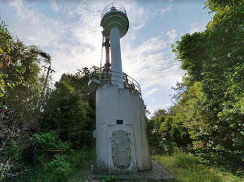
1953. Active; focal plane 40 m (131 ft); white flash every 4 s; in addition, a spotlight (JCG-3094) illuminates the north breakwater across from the lighthouse. 13 m (43 ft) concrete post with gallery, mounted atop a round 1-story concrete equipment room. Entire lighthouse is white. Leonard Lawrence has the closeup street view at right, Lighthouse-Japan.com has a page with photos, FOAL's page has closeup photos, Misty's Tour has additional photos, Lighthouse Visit has photos (second lighthouse on the page), Trabas has a distant view, and Google has a satellite view. Located on a promontory on the south side of the entrance to the Shimanto estuary. Accessible by a short walk but local guidance would be helpful. Site open, tower closed. . ARLHS JPN-416; JCG-3093; Admiralty M5600; NGA 10260.

Nishidō Saki Light, Tosashimizu, May 2019
Google Maps street view by Leonard Lawrence
* Nuno Saki
1955. Active; focal plane 58 m (190 ft); white flash every 5 s. 10 m (33 ft) concrete post with gallery, mounted atop a square 1-story concrete equipment room. Entire lighthouse is white. Trabas has a closeup photo, Lighthouse-Japan.com has a page with photos, FOAL's page has many photos, Lighthouse Visit has a page for the lighthouse, Misty's Tour has another photo, a closeup is available, and Google has a satellite view. Located on a prominent cape at the northeast corner of the Ashizuri peninsula about 15 km (9 mi) northeast of Tosashimizu. Local guidance may be needed to find the lighthouse. Site open, tower closed. ARLHS JPN-439; JCG-3095; Admiralty M5601; NGA 10264.
Shimonokae (Simonokae) Kō
Date unknown. Active; focal plane 14 m (46 ft); green flash every 3 s. 11 m (36 ft) round concrete tower with a flared top, attached to a small equipment shelter. Entire lighthouse is white. Trabas has a photo, Lighthouse Visit has photos, Tomokatsu Takeuchi has a 2023 sunset photo, and Google has a satellite view. Located on a detached breakwater on the east side of Shimonokae, about 2.5 km (1.5 mi) west of Nuno Saki. Accessible only by boat. Site open, tower closed. ARLHS JPN-568; JCG-3095.8; Admiralty M5601.3; NGA 10266.
Iburi Kō (Outer Breakwater)
Date unknown. Active; focal plane 15 m (49 ft); two green flashes every 6 s. 10 m (33 ft) round concrete tower with a flared top, attached to a small equipment shelter. Entire lighthouse is white. Trabas has a closeup photo, FOAL has photos (this light is on the left), and Google has a satellite view. Located at the north end of the detached breakwater of Iburi, a fishing port about 15 km (9 mi) north of Cape Ashizuri. Accessible only by boat. Site open, tower closed. JCG-3096.8; Admiralty M5601.8; NGA 10270.
* Iburi Kō South Breakwater
Date unknown. Active; focal plane 14 m (46 ft); green flash every 5 s. 9.5 m (31 ft) round concrete tower with a flared top, attached to a small equipment shelter. Entire lighthouse is white. Trabas has a closeup photo, FOAL has photos (this light is on the right), and Google has a satellite view. Located at the end of the south breakwater of Iburi. Accessible by walking the pier. Site open, tower closed. JCG-3097; Admiralty M5601.9; NGA 10272.
* Kubotsu (Kubotu) Saki
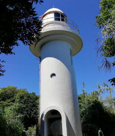
1962. Active; focal plane 51 m (167 ft); white flash every 15 s; also a continuous white spotlight (JCG-3100) illuminates the Yusuga Bae reef offshore. 11 m (36 ft) round cylindrical concrete tower with lantern and gallery. Entire lighthouse is white. Lighthouse-Japan.com has a good page for this lighthouse, Trabas has a nice closeup, FOAL's page has good photos, Misty's Tour has an additional photo, Lighthouse Visit also has photos, and Google has a distant street view. Located on a promontory about 5 km (3 mi) east of Tosashimizu and 8 km (5 mi) north of "land's end" at Ashizuri Saki. The lighthouse stands close to the paved coastal highway, as seen in a Google satellite view; some limited parking is available. Site open, tower closed. . ARLHS JPN-295; JCG-3099; Admiralty M5601.6; NGA 10276.

Kobotsu Saki Light, Tosashimizu, September 2021
Google Maps photo by mi i
** Ashizuri (Asizuri) Saki (Cape Ashizuri)
1914. Active; focal plane 61 m (200 ft); three white flashes every 30 s; in addition, a spotlight (JCG-3102) illuminates the nearby Yusuga reef. 18 m (59 ft) round cylindrical concrete tower with lantern, gallery, and four ribs. Entire lighthouse is white. Katunori Tanimoto's 2024 photo is at the top of this page, Wikimedia has a good photo, Lighthouse-Japan.com has a fine page with many photos, Trabas has a good photo, FOAL's page has good photos, Misty's Tour has a good photo, Lighthouse Visit has photos of the lighthouse in action, and Google has a street view and a satellite view. Ashizuri Saki, the southernmost point of Shikoku, is a popular tourist destination; parking is provided and there is a visitor center seen in a Google street view. The lighthouse stands on a very steep, almost knifelike promontory at the southeastern corner of the Ashizuri peninsula, commanding a spectacular view of the Pacific. Site open, tower closed. . ARLHS JPN-029(=2485); JCG-3101; Admiralty M5602; NGA 10284.
* Usubae (Uzubae) Saki
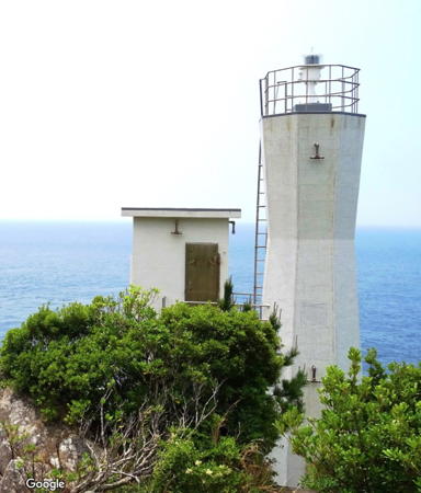
1961. Active; focal plane 51 m (167 ft); two white flashes every 10 s; in addition, a spotlight (JCG-3104) illuminates a nearby reef. 9.5 m (31 ft) octagonal hourglass-shaped concrete tower, attached to a small 2-story equipment concrete equipment building. Entire lighthouse is white. Eizō Yamashita's photo is at right, Trabas has a closeup photo, Lighthouse-Japan.com has a page with several good photos, Lighthouse Visit also has a page, FOAL's page has closeup photos, Misty's Tour has an additional photo, and Google has a satellite view. Sibling of the Shira Saki lighthouse (see below). Located atop a spectacular cliff at the southwestern tip of the Ashizuri peninsula, about 7 km (4.5 mi) west of Ashizuri Saki. Accessible by road and a hiking trail, but parking is quite limited. Site open, tower closed. . ARLHS JPN-729; JCG-3103; Admiralty M5603; NGA 10288.
* Tosashimizu (Tosa Simizu) Kō
1952. Active; focal plane 46 m (151 ft); flash every 4 s, white or red depending on direction; the red light is shown over shoals to the southwest. There is also a continuous white spotlight (JCG-3105.01) that illuminates a nearby reef. 13 m (43 ft) round cylindrical concrete tower attached to a 1-story concrete equipment building. Lighthouse-Japan.com has a page with several photos, FOAL's page has closeup photos, Trabas has a distant view, Lighthouse Visit has photos, Misty's Tour has another good photo, and Google has a satellite view. Located on the west side of the entrance to Tosashimizu harbor. Not easy to find; the path to the lighthouse appears to cross private property. Site open, tower closed. . ARLHS JPN-680; JCG-3105; Admiralty M5604; NGA 10296.

Usubae Saki Light, Tosashimizu, May 2018
Google Maps photo by Eizō Yamashita
Tosashimizu (Ashizuri, Hira Bae) Kō East Breakwater
Date unknown. Active; focal plane 13 m (43 ft); red light, 2 s on, 2 s off. 9.5 m (31 ft) concrete post with gallery mounted atop a square 1-story concrete equipment room. Entire lighthouse is red. FOAL's page has photos, Lighthouse Visit has photos (second lighthouse on the page), Trabas has a closeup, and Google has a satellite view. Located at the end of a small breakwater at the entrance to Tosashimizu harbor. Accessible only by boat. Site open, tower closed. ARLHS JPN-2488; JCG-3106; Admiralty M5605; NGA 10304.
* Tosashimizu (Ashizuri) Kō West Breakwater
Date unknown. Active; focal plane 13 m (43 ft); green flash every 5 s. 8.5 m (28 ft) concrete post with gallery, mounted atop a square 1-story concrete equipment room. Entire lighthouse is white. FOAL's page has photos, Lighthouse Visit has photos (near the bottom of the page), Trabas has a closeup photo, a closeup and a 2023 photo are available, and Google has a satellite view. Located at the end of the west breakwater at the entrance to Tosashimizu harbor. Accessible by walking the pier. Site open, tower closed. JCG-3107; Admiralty M5606; NGA 10308.
Yōrō (Ashizuri) Kō West Breakwater
Date unknown. Active; focal plane 16 m (52 ft); green light, 3 s on, 3 off. 11 m (36 ft) round concrete tower with a flared top, attached to a small equipment shelter. Entire lighthouse is white. Trabas has a closeup, FOAL's page has photos, a 2022 view is available, and Google has a satellite view. Located at the end of the west breakwater of Yōrō harbor, on the west side of Ashizuri village. Accessible by walking the piert. Site open, tower closed. ARLHS JPN-2486; JCG-3109; Admiralty M5607.3; NGA 10292.
* Kanae (Kano, Kanai) Saki
1911. Active; focal plane 40 m (131 ft); white flash every 5 s. 8 m (26 ft) octagonal cylindrical brick tower, painted white. Yukihiro Matsumura's 2023 photo is at right, Lighthouse-Japan.com has a good page for the lighthouse, Trabas has an excellent photo, FOAL's page has excellent photos, Lighthouse Visit has a page with photos, Misty's Tour has three fine photos, a 2022 closeup is available, S. Morita has a 2009 photo, and Google has a street view and a satellite view. Located on a prominent cape about 14 km (8.5 mi) west of Tosashimizu. Accessible by road but parking is limited. Site open, tower closed. . ARLHS JPN-223; JCG-3110; Admiralty M5608; NGA 10312.

Ōtsuki Town Lighthouses
Komame Saki
1972. Active; focal plane 91 m (299 ft); white flash every 4 s. 12 m (39 ft) concrete post with gallery, attached to a small 1-story concrete equipment room. Entire lighthouse is white. Lighthouse-Japan.com has a page with a closeup photo, Lighthouse Visit has a page with photos, FOAL's page has closeup photos, Trabas has a distant view, and Google has a satellite view. This lighthouse is in a particularly rugged area. Located at the tip of a forested peninsula about 6 km (3.5 mi) south of Ōtsuki. Accessible by a fairly demanding hiking trail. Site open, tower closed. ARLHS JPN-282; JCG-3112; Admiralty M5608.7; NGA 10320.
Kashiwa (Kasiwa) Shima
1946. Active; focal plane 156 m (512 ft); two white flashes every 10 s. 11 m (36 ft) round hourglass-shaped concrete tower with gallery. Entire lighthouse is white. Lighthouse-Japan.com has a page with a closeup photo, FOAL's page has closeup photos, Lighthouse Visit has photos, Ryuta Takesaki has a 2021 drone view, Misty's Tour has a distant view, Trabas has a distant view, and Google has a satellite view. Kashiwa Shima is a small island just barely off the southwestern tip of Shikoku, connected to the mainland by a bridge. Located on the highest point of the island, near the western tip. Accessible by an obscure path that begins at the island's elementary school. Site open, tower closed. ARLHS JPN-240; JCG-3115; Admiralty M5609.5; NGA 10336.
* Kashiwa Shima (Kashiwajima) Kō
1956. Active; focal plane 14 m (46 ft); red light, 2 s on, 2 s off. 10 m (33 ft) concrete post with gallery, mounted atop a square 1-story concrete equipment room. Entire lighthouse is red. Lighthouse Visit has photos (bottom of the page), FOAL has additional photos (bottom of the page), Trabas has a closeup photo, and Google has a street view and a satellite view. Located at the eastern tip of an island protecting Kashiwa Shima harbor. Site open, tower closed. ARLHS JPN-241; JCG-3116; Admiralty M5609; NGA 10340.

Kanae Saki Light, Tosashimizu, October 2023
Instagram photo by Yukihiro Matsumura
Eboshi (Ebosi) Saki (Okino Shima North Point)
1986. Active; focal plane 64 m (210 ft); white flash every 3 s. 10 m (33 ft) round cylindrical concrete tower. Entire lighthouse is white. Lighthouse-Japan.com has a page with a closeup photo, another closeup is available, and Google has a satellite view. Tosa Okino Shima is an island about 6 km (3.5 mi) long located about 8 km (5 mi) southwest of the southwestern tip of Shikoku. Most of the heavily forested island is a national park, with campgrounds and hiking trails. Ferry transportation to the island is available from Sukumo on the mainland of Shikoku. Located at the northern tip of Tosa Okino Shima. Apparently accessible by a hiking trail (local knowledge probably needed). Site open, tower closed. ARLHS JPN-676; JCG-3114.5; Admiralty M5610.12; NGA 10324.
* Tosa Okino Shima (Kushiga Hana)
1933. Active; focal plane 174 m (571 ft); two white flashes every 30 s. 15 m (49 ft) round concrete tower with lantern and gallery, attached to a large 2-story concrete communications building. Entire lighthouse is white. Yukihiro Matsumura's 2023 photo is at right, Lighthouse-Japan.com has a page with good photos, the Coast Guard has a photo, a 2021 closeup is available, and Google has a satellite view. This very important lighthouse marks the entrance to the Bungo Strait, a broad sound separating the islands of Shikoku and Kyūshū. The lighthouse is located at Kushiga Hana, the southwestern tip of Okino Shima. Site open, tower closed. . ARLHS JPN-678; JCG-3113; Admiralty M5610; NGA 10332.
Shira (Sira) Saki
1959. Active; focal plane 56 m (184 ft); white flash every 4 s; in addition, a spotlight (JCG-3118) illuminates the nearby islet of Kojima. 9.5 m (31 ft) octagonal concrete tower. Entire lighthouse is white. FOAL's page for the lighthouse has closeup photos, Lighthouse Visit's page has similar photos, and Google has a satellite view. Located at the western tip of a sharp peninsula projecting into Bungo Strait about 7 km (4.5 mi) northwest of Ōtsuki. Accessible by a twisting mountain road and a hiking trail; the entrance is marked but parking is limited. Site status unknown. ARLHS JPN-575; JCG-3117; Admiralty M5610.2; NGA 10520.

Sukumo City Lighthouses
* Tosa Nagasaki Hana (Sukumo)
1962. Active; focal plane 70 m (230 ft); three white flashes every 13 s; also a spotlight (JCG-3120) illuminates the nearby skerry known as Ko Shima. 9.5 m (31 ft) round concrete tower attached to a small 2-story equipment building; the spotlight is shown through a square window at the top of the equipment building. Entire lighthouse is white. Lighthouse-Japan.com has a page with several photos, FOAL's page for the lighthouse has good photos, Lighthouse Visit also has a page, Misty's Tour has additional photos, a closeup is available, and Google has an indistinct satellite view. Located at the tip of a forested peninsula on the south side of the entrance to the harbor of Sukumo. Accessible by a hiking trail from the port. Site open, tower closed. . ARLHS JPN-677; JCG-3119; Admiralty M5610.4; NGA 10516.
* Ikeno Shima (Ikeshima)
1954. Active; focal plane 58 m (190 ft); white light, 3 s on, 3 s off. 9 m (30 ft) concrete post, attached to a hexagonal 1-story concrete equipment room. Entire lighthouse is white. Lighthouse-Japan.com has a page with photos, Lighthouse Visit has a photo (middle of the page), Hitoshi Sato has a 2022 photo, Misty's Tour has additional photos, Trabas has a distant view, and Google has a satellite view. Located on a forested peninsula just west of the harbor of Sukumo. Accessible by a short walking path from the port; parking is available. Site open, tower closed. ARLHS JPN-159; JCG-3123; Admiralty M5610.5; NGA 10512.

Tosa Okino Shima Light, Ōtsuki, October 2023
Instagram photo by Yukihiro Matsumura

Information available on lost lighthouses:

Notable faux lighthouses:

Adjoining pages: Northeast: Northern Kōchi | West: Western Ehime

Return to the Lighthouse Directory index | Ratings key

Posted April 23, 2007. Checked and revised February 10, 2024. Lighthouses: 30. Site copyright 2024 Russ Rowlett and the University of North Carolina at Chapel Hill.