Lighthouses of South Korea: Incheon Area

For most of its history Korea was an independent kingdom, or at least an autonomous kingdom under Chinese influence. This came to an end in 1910 when Japan annexed all of Korea. At the end of World War II in 1945 the 38° parallel was established as the dividing line between U.S. and Soviet zones of occupation, and in 1948 separate civil administrations were established in the two halves of the country. The Korean War (1950-53) ended in a draw with the armistice line falling close to the prewar 38° line. The Republic of Korea (ROK), commonly called South Korea (Daehan Minguk in Korean), occupies the Korean peninsula south of the armistice line.

South Korea is divided into nine provinces and eight province-level cities; the provinces are subdivided into counties and cities. This page covers lighthouses of South Korea's northwest coast in the metropolitan (province-level) city of Incheon (Inchon), including the city proper, Ganghwa County, and the western islands of Ongjin County. This coast faces west on the Yellow Sea (or the West Sea, as it is called in Korea). There is a separate page for the southern islands of Ongjin County.

In 2000 South Korea adopted a Revised Romanization System to replace systems formerly used in the West. In the Revised System, the word for a lighthouse is deungdae (등대); dan (formerly tan) is a cape, seom (som) or do (to) is an island, am or amseog is a rock, man is a bay, and hang is a harbor. Some place names may be more familiar to Westerners in the spellings of older systems.

Navigational aids in the ROK are regulated by the Ministry of Oceans and Fisheries (MOF). In this area the lights are maintained by the Incheon Regional Office of Oceans and Fisheries. MOF also operates the major coastal lights, but management of harbor lighthouses is in the hands of local port authorities.

ARLHS numbers are from the ARLHS World List of Lights. KR numbers, where available, are from the Korean light list. Admiralty numbers are from volume M of the Admiralty List of Lights & Fog Signals. U.S. NGA

General Sources
Online List of Lights - Korea
Photos by various photographers posted by Alexander Trabas.
Navionics Charts
Navigation chart for the Incheon area.
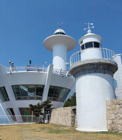

Old and new Palmido Lights, Incheon Harbor, April 2022
Instagram photo by Oleg Kiriyanov
Incheon City Lighthouses

Jung District: Yongjeongdo and Daemuuido Lighthouses
The Jung (Central) District includes the central district of Incheon and islands immediately west of the downtown area. The island of Yongjeongdo was expanded by reclamation so that it now includes the former island of Yongyudo to the west. The smaller island of Daemuuido is south of Yongyudo.
Seosudo (Seo Sudo)
Date unknown. Active; focal plane 17 m (56 ft); red flash every 6 s. 17 m (56 ft) round tower with lantern and gallery mounted on a circular platform supported by three piles. Lighthouse painted red. No photo available and the island is not shown in Google's satellite view. The outbound shipping lane of Incheon passes just north of this light. Located on a shoal about 5 km (3 mi) southwest of Daemuuido. Accessible only by boat. Site open, tower closed. Admiralty M4165; NGA 17954.
Haerido (Haenyeodo, Haenyeo)
2005. Active; focal plane 21 m (69 ft); green flash every 5 s. 18 m (56 ft) round cylindrical white concrete tower with lantern and gallery. Access to the tower is by a stairway that spirals once around the base of the tower. A photo is at right, a view from the sea is available, and Google has a satellite view. Located on the south point of Haerido, a small island off the southeast end of Daemuuido. Accessible only by boat. Site open, tower closed. KR-3562.3; Admiralty M4167.4; NGA 17960.1.
* Gwangmyeang Hang
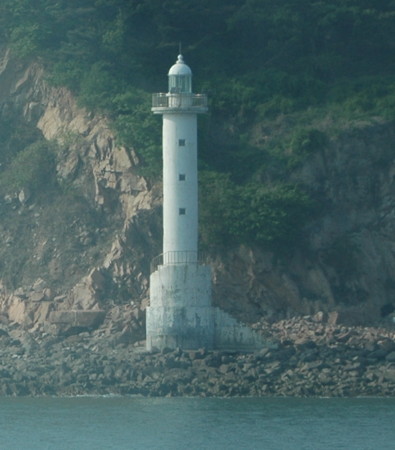
Date unknown. Active; focal plane 17 m (56 ft); green flash every 5 s. 7 m (23 ft) square white metal tower. A distant view is available and Google has a satellite view. Located on the breakwater of a small harbor at the south end of Daemuuido. Accessible by walking the pier. Site open, tower closed. KR-3562.5; Admiralty M4167.5.
Baedongcho (Paedangcha)
Date unknown. Active; focal plane 13 m (43 ft); two white flashes every 5 s. 12.5 m (41 ft) round tower, painted black with one red horizontal band. No photo available but Google has a satellite view. Located on a shoal about 1 km (0.6 mi) off the eastern point of Daemuuido. Accessible only by boat. Site open, tower closed. KR-3562; Admiralty M4167.3; NGA 17961.
* Palmido (1)
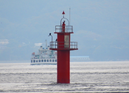
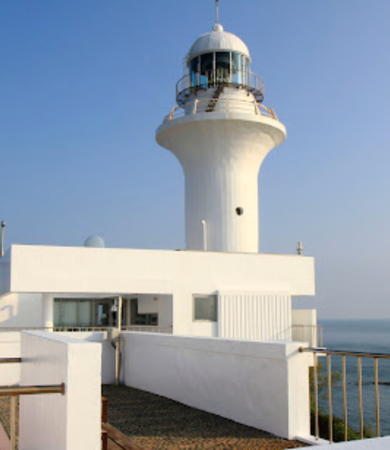
1903. Inactive since 2003. 8 m (26 ft) round cylindrical concrete tower with lantern and gallery, painted white. Fog horn (one blast every 30 s). This lighthouse is in the foreground of Oleg Kiriyanov's photo at the top of this page, Jeongeun Seo has a 2023 photo, Si Chun has a 2020 photo taken from the newer lighthouse, there's a 2019 photo of both lighthouses, and Google has a satellite view (the old tower is centered in this view, just below and to the right of the new lighthouse). Palmido is an island in the entrance to Incheon harbor; ships make a turn around the island to enter. This was Korea's first lighthouse, built when Japan pressured the Korean monarchy into opening its ports to trade. In the Korean War, U.S. special forces relit the lighthouse to guide the amphibious assault on Incheon on 15 September 1950. Located at the highest point of a small island about 10 km (6 mi) southwest of the Incheon waterfront and 7 km (4.5 mi) east southeast of Daemuuido.
Haerido Light
Haerido Light, Incheon, March 2012
ex-Panoramio photo copyright plumgarden; used by permission
* Palmido (2)
2003 (station established 1903). Active; focal plane 71 m (233 ft); four white flashes every 40 s. 26 m (85 ft) round cylindrical concrete tower with lantern and gallery, mounted atop a striking vase-shaped concrete and marble building described as a "High-Tech Lighthouse and Exhibition Center." Lighthouse painted white; the lantern dome is gray metallic. Fog horn (one blast every 30 s). Oleg Kiriyanov's photo is at the top of this page, a 2018 photo of the two lighthouses is available, there's a 2019 photo of both lighthouses, and Google has a satellite view. Located northwest and downslope from the historic lighthouse. Accessible only by boat; ferry service is available. Site open, tower status unknown. . Admiralty M4167; NGA 17960.
Wangsan Marina
Date unknown. Active; focal plane about 23 m (75 ft); green light, pattern unknown. Approx. 20 m (66 ft) round cylindrical white concrete tower with lantern and two galleries. Olivia Moon has a photo, a view across the marina is available, and Google has a satellite view. Located on the breakwater of a large marina at the west end of Yongjeongdo. Accessible by walking the pier. Site open, tower closed. Admiralty M4147.8.

Incheon Waterfront: Yeonsu District Lighthouses
* Incheon International Cruise Terminal
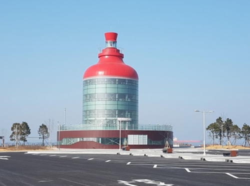
2018. Active; focal plane 27 m (89 ft); red flash every 7 s. 25 m (82 ft) lantern centered atop a domed 5-story round building. Dome and lantern are red. A photo is at right and Google has a satellite view. Located at the end of the cruise ship quay at the south end of Incheon harbor. Site open, tower status unknown. KR-3569.7; Admiralty M4170.97.

Cruise Terminal Light, Incheon, March 2012
Google Maps photo by 미주부동산

Incheon Waterfront: Jung (Central) District Lighthouses
Incheon Coal Wharf A
Date unknown. Active; focal plane 15 m (49 ft); yellow flash every 7 s. 9 m (30 ft) round concrete tower painted yellow. No photo available but Google has a satellite view. Located at the south (outer) end of the coal terminal wharf. Site and tower closed. KR-3577; Admiralty M4171; NGA 17963.
Incheon Coal Wharf B
Date unknown. Active; focal plane 14 m (46 ft); yellow flash every 5 s. 8 m (26 ft) round concrete tower painted yellow. No photo available but Google has a satellite view. Located at the north end of the coal terminal wharf. Site and tower closed. KR-3578; Admiralty M4171.2; NGA 17963.5.
* Incheon (Sangyong) East Breakwater
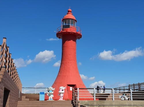
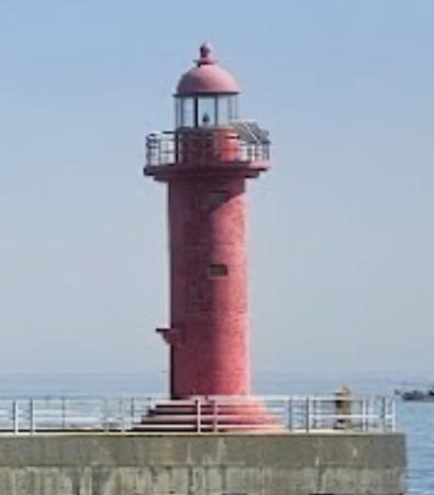
Date unknown. Active; focal plane 18 m (59 ft); red flash every 5 s. Approx. 15 m (49 ft) round tapered concrete tower with a small lantern and gallery. Entire lighthouse is red. Yoo Seung-woo's photo is at right, another photo is available and Google has a satellite view. Located at the end of the breakwater, about 500 m (0.3 mi) southwest of the Sowolmido lighthouse (next entry). Accessible by walking the pier. Site open, tiower closed. . KR-3601; Admiralty M4173.3; NGA 17965.5.
Sowolmido (Incheon South Breakwater Elbow)
Date unknown. Active; focal plane 20 m (66 ft); green flash every 5 s. 15 m (49 ft) round concrete tower with lantern and gallery. Entire lighthouse is white. A photo (1/4 the way down the page), is available and Google has a street view and a satellite view. Located at the elbow (bend) of the Solwolmido south breakwater. Site and tower closed. KR-3604; Admiralty M4173.4; NGA 17967.
Incheon South Breakwater Head
Date unknown. Active; focal plane 14 m (46 ft); three red flashes every 7 s. 9 m (30 ft) round tapered concrete tower, painted red. No photo available but Google has a satellite view. Located at the end of the breakwater, about 600 m (0.38 mi) north of the Sowolmido lighthouse. Site and tower closed. KR-3593; Admiralty M4173.5; NGA 17967.5.

East Bteakwater Light, Incheon, September 2021
Google Maps photo by Yoo Seung-woo
Incheon North Breakwater Head
Date unknown. Active; focal plane 14 m (46 ft); three green flashes every 7 s. 9 m (30 ft) octagonal concrete tower, painted white. No photo available but Google has a satellite view. Located at the end of the breakwater. Site and tower closed. KR-3598; Admiralty M4173.52; NGA 17968.
Incheon Lock Gate South (2)
Date unknown. Active; focal plane about 20 m (66 ft); red flash every 5 s. Approx. 14 m (46 ft) concrete tower with lantern and gallery, centered on a square concrete equipment building. Entire lighthouse is red. No photo available but Google has a satellite view. NGA lists a 9 m (30 ft) square tower. Located at the end of a short breakwater north of the lock entrance to Incheon's inner harbor. Site status unknown. KR-3607; Admiralty M4173.6; NGA 17968.5.
* Incheon Lock Gate North (Wolmido) (2?)
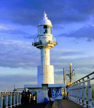
Date unknown. Active; focal plane about 17 m (56 ft); three green flashes every 7 s. Approx. 12 m (39 ft) round concrete tower with lantern and gallery, centered on a square concrete equipment building. Entire lighthouse is white; at night it is floodlit in green. A photo is at right, David Hoe has a 2019 photo, Soonho Yoon has a closeup photo, Glen Choi has a sunset photo, Maik Heller has a street view, and Google has a satellite view. NGA lists a 9 m (30 ft) octagonal tower. Located at the end of a short breakwater at Wolmido Park, north of the lock entrance to Incheon's inner harbor. Accessible by walking the pier. Site open, tower closed. . KR-3610; Admiralty M4173.8; NGA 17969.
Seoduam (Sodu Am)
Date unknown. Active; focal plane 16 m (52 ft); red flash every 4 s. 16 m (52 ft) round cylindrical concrete tower mounted on a round 1-story concrete base. Entire lighthouse painted red. Bo Kage Carlson has a view from the port, a distant view is available, and Google has a satellite view. Located on a dangerous rock just off the Incheon waterfront. Accessible only by boat. Site status unknown. KR-3615; Admiralty M4174; NGA 17971.5.

Incheon Waterfront: Dong District Lighthouse
Jagyakdo (Chagyak-To)
Date unknown. Active; focal plane 58 m (190 ft); two white flashes every 6 s. 20 m (66 ft) triangular white concrete skeletal tower with an octagonal observation room and gallery. A closeup photo (halfway down the page) is available and Google has a satellite view. Jagyakdo is an island just off the Incheon waterfront, north of Sodu Am. Located at the eastern end of the island. Accessible only by boat. Site open, tower probably open. KR-3628; Admiralty M4176; NGA 17972.

Lock Gate North Light, Incheon, July 2019
Google Maps photo by 여행투어버스

Incheon Waterfront: Seogu (Western) District Lighthouse
Incheon Buk Hang (North Harbor)
Date unknown. Active; focal plane 12 m (39 ft); white flash every 5 s. 7 m (23 ft) round white concrete tower. No photo available but Google has a satellite view. Located at the southwest corner of the north harbor quays. Site and tower closed. Admiralty M4176.3; NGA 17973.

Ganghwa County Lighthouses

Ganghwado is a large island north of Incheon, separated from the mainland by a narrow channel and adjacent to the armistice line separating North and South Korea. Ganghwa County includes Ganghwado and several smaller islands to the west.

Gilsang Township (Ganghwado East Coast) Lighthouse
Chojiri
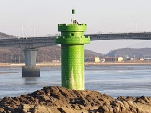
2006. Active; focal plane 12 m (39 ft); green light every 6 s. 12 m (39 ft) round cylindrical concrete tower with double gallery, painted green. Yang Moon-su has a 2021 photo and Google has a street view and a satellite view. Located on a shoal on the west side of the channel separating Ganghwado from the mainland, about 600 m (0.4 mi) north of the southern bridge to the island. Accessible only by boat, but easy to see from shore. Site open, tower closed. KR-3713.10; Admiralty M4181.

Hajeom Township (Ganghwado West Coast) Lighthouse
Changhuri (Songmodo)
Date unknown. Active; focal plane 12 m (39 ft); red flash every 6 s. 19 m (62 ft) round tower, painted red. A photo (1/4 the way down the page) is available and Google has a satellite view. Located on a rock in the channel off the northwest side of Ganghwado. Accessible only by boat. Site status unknown. KR-3727; Admiralty M4146.6; NGA 18076.5.

Samsan Township (Seongmodo) Lighthouse
Gajinyeo
Date unknown. Active; focal plane 15 m (49 ft); red flash every 5 s. 15 m (49 ft) round cylindrical concrete tower, painted red. Kim Cheol Bong's photo is at right and Google has a distant satellite view. Located in the channel between Ganghwado and Seongmodo, largest of the islands west of Ganghwado. Accessible only by boat. Site open, tower closed. KR-3718; Admiralty M4147.
Jakeunguduldol
Date unknown. Active; focal plane 11 m (36 ft); green flash every 5 s. 12 m (39 ft) round cylindrical concrete tower, painted green. No photo available but Google has a distant satellite view. Located in the channel between Ganghwado and Seongmodo. Accessible only by boat. Site open, tower closed. KR-3716; Admiralty M4146.7.
Eoyujeong Hang
Date unknown. Active; focal plane 52 m (171 ft); three white flashes every 7 s. 17 m (56 ft) octagonal white concrete tower with lantern and gallery; the lantern roof is green. No closeup photo available but Google has a satellite view and a distant street view. Located at the south point of Seokmodo Island, marking the southern entrance to the 3 km (1.8 mi) wide channel between Ganghwado and Seongmodo. Site status unknown. KR-3714.3; Admiralty M4146.55.
Eoyujeong Hang South Breakwater East End
Date unknown. Active; focal plane 17 m (56 ft); green flash every 4 s. Approx. 8 m (26 ft) round cylindrical white concrete tower. This light is at the left in Orynbassar Kassymbay's photo, Kim Jang Won has a street view, and Google has a satellite view. Located at the east end of the detached breakwater protecting Eoyujeong harbor. Accessible only by boat. Site open, tower closed. KR-3714.10; Admiralty M4146.554.

Gajinyeo Light, Ganghwado, October 2014
ex-Panoramio photo copyright Kim Cheol Bong; used by permission
Eoyujeong Hang South Breakwater West End
Date unknown. Active; focal plane 17 m (56 ft); red flash every 4 s. Approx. 8 m (26 ft) round cylindrical red concrete tower. Kim Soon Hee has a photo, this light is at the left in Kim Tae Hoon's photo, Kim Jang Won has a street view, and Google has a satellite view. Located at the west end of the detached breakwater protecting Eoyujeong harbor. Accessible only by boat. Site open, tower closed. KR-3714.11; Admiralty M4146.553.
Eoyujeong Hang Southwest Breakwater South End
Date unknown. Active; focal plane 17 m (56 ft); green flash every 4 s. Approx. 8 m (26 ft) round cylindrical white concrete tower. This light is at the right in Kim Tae Hoon's photo and Orynbassar Kassymbay's photo, Kim Jang Won has a street view, and Google has a satellite view. Located at the west end of the detached breakwater protecting Eoyujeong harbor. Accessible only by boat. Site open, tower closed. KR-3714.9; Admiralty M4146.552.

Seodo Township Lighthouses
Seodo Township includes islands southwest of Seongmodo; the largest of these islands are Jumundo and Boreumdo. Achado is a smaller island northwest of Jumundo and east of Boreumdo.

Gakyeo (Susido)
Date unknown. Active; focal plane 15 m (49 ft); green flash every 4 s. 19 m (62 ft) round green concrete tower. No photo available but Google has a satellite view. Located on a shoal off the southeast tip of Jumundo and at the southeastern end of the Seodo islands. Accessible only by boat. Site open, tower closed. KR-3710.1; Admiralty M4146.51; NGA 18078.
Somaldeungyeo (Jumundo)
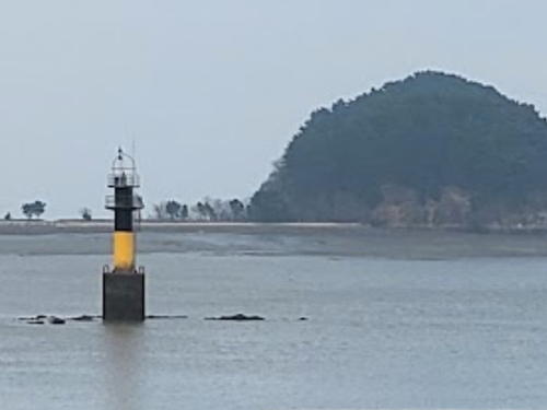
Date unknown. Active; focal plane 12 m (39 ft); quick-flashing white light. 12 m (39 ft) round concrete tower, upper half painted black and lower half yellow. Makgeol Lee's 2022 photo is at right, another photo is available and Google has a satellite view. Located on a shoal off the Daebinchang ferry port at the north end of Jumundo. Accessible only by boat. Site open, tower closed. KR-3715.5; Admiralty M4146.522.
Daemaeyeo (Achado Northeast)
2007. Active; focal plane 11 m (36 ft); green flash every 6 s. 17 m (56 ft) round cylindrical concrete tower with double gallery, mounted on a round concrete pier. Entire lighthouse is green. A photo (halfway down the page) is available and Google has a satellite view. Located off the northeast side of Achado island, about 10 km (6 mi) southwest of Seokmodo. Accessible only by boat. Site open, tower closed. KR-3715.6; Admiralty M4146.53.
Boreumdo
Date unknown. Active; focal plane 13 m (43 ft); red flash every 4 s. 14 m (46 ft) round cylindrical red concrete tower. No photo available but Google has a satellite view. Located on a shoal in the passage between Jumundo and Boreumdo. Accessible only by boat. Site open, tower closed. KR-3715; Admiralty M4146.52.
 

Somaldeungyeo Light, Jumundo, November 2022
Google Maps photo by Makgeol Lee
 

Western Ongjin County Lighthouses

Bukdo Township Lighthouses
The Bukdo (North) Islands are a small group lying off the northwest side of Yongjeongdo and south of Ganghwado.

Sindo Ri
Date unknown. Active; focal plane 11 m (36 ft); green flash every 5 s. 15 m (49 ft) round green concrete tower on a round concrete pier. No photo available but Google has a satellite view. Locared off the northeast corenr of Sindo marking the entrance to the passage between that island and Yongjeongdo. Accessible only by boat. Site open, tower closed. KR-3629; Admiralty M4146.59.
Soeyeo (Seoyeo, Soiyo)
Date unknown. Active; focal plane 13 m (43 ft); two white flashes every 5 s. 14 m (46 ft) round tower, painted black with one red horizontal band. No photo available but Google has a satellite view. Located on a reef about 20 km (13 mi) southwest of Ganghwado. Accessible only by boat. Site status unknown. KR-3710; Admiralty M4146.5; NGA 18077.
Sindo
Date unknown. Active; focal plane 49 m (161 ft); two white flashes every 6 s. 6 m (20 ft) round white concrete tower. No photo available but Google has an indistinct satellite view. This Sindo is a tiny island in the Yellow Sea about 45 km (28 mi) west of Incheon. Located on the highest point of the island. Site and tower closed. KR-3709; Admiralty M4146; NGA 18076.
Goseoki
Date unknown. Active; focal plane about 12 m (39 ft); nine quick white flashes followed by one long white flash every 15 s. Approx. 10 m (33 ft) post carrying a large gallery mounted on a concrete base. No photo available but Google has an indistinct satellite view. The light guides vessels approaching the north side of Yongjeongdo. Located on a reef at the southwestern end of the Bukdo Islands. Accessible only by boat. Site and tower closed. KR-3656.3; Admiralty M4147.6.

The remaining islands lie well to the west of Incheon and closer to the coast of North Korea than to the rest of South Korea. They were held by Allied forces during the Korean War and remained under South Korean control following the armistice agreement. The Yeonpyeong islands lie off the south coast of North Korea's Hwanghae province. The Daecheong and Baengnyeong islands lie farther west, off the southwestern tip of North Korea. In recent years North Korea has asserted a claim over the waters surrounding these islands, and this has led to several military clashes.

Yeonpyeong Township Lighthouses
Yeonpyeong (Yonpang) North Breakwater East Head
2012. Active; focal plane 18 m (59 ft); red flash every 6 s. 14 m (46 ft) round cylindrical concrete tower with lantern and gallery. Entire lighthouse is red. Shin-ha Shin has a photo, Lee Jong-sik has a 2022 photo, and Google has an indistinct satellite view. Yeonpyeong is a triangular island about 4 km (2.5 mi) in diameter lying north of Soyeonpyeong. Located on an east spur extending the north breakwater of Yeonpyeong. Possibly accessible by walking the pier. Site status unknown. KR-3724.6; Admiralty M4137.3.
Yeonpyeong (Yonpang) North Breakwater Southwest Head
Date unknown. Active; focal plane 15 m (49 ft); red flash every 6 s. 9 m (30 ft) octagonal red concrete tower. A photo is at right, this light is on the left in Lee Jong-sik's 2022 photo, and Google has a satellite view. Located at the end of the east (main) breakwater of Yeonpyeong. Possibly accessible by walking the pier. Site status unknown. KR-3723; Admiralty M4137.4; NGA 18088.
Yeonpyeong (Yonpang) South Breakwater
Date unknown. Active; focal plane 13 m (43 ft); green flash every 6 s. 9 m (30 ft) octagonal white concrete tower. Lee Jong-sik has a 2022 photo, a closeup (halfway down the page) is available and Google has a satellite view. Located on the south breakwater of the port on the southeast side of the island. Site and tower closed. Admiralty M4137.2; NGA 18087.
* Soyeonpyeong (Soyonpyong)
Date unknown. Active; focal plane 39 m (128 ft); two white flashes every 6 s. 6 m (20 ft) round white concrete tower. Kim Baek Seon has a closeup photo, several photos (2/3 the way down the page) are available, and Google has a satellite view. Soyeonpyeong is an island about 1.2 km (3/4 mi) in diameter, located in the Yellow Sea about 40 km (25 mi) south of Haeju and 5 km (3 mi) southeast of Yeonpyeong. The islands are accessible by ferry from Incheon. Located on the southeastern point of the island. Site open, tower closed. Admiralty M4145; NGA 18080.
Nounseo (Nounso, Noleunyeo)
Date unknown. Active; focal plane 16 m (52 ft); two white flashes every 10 s. 16 m (52 ft) round stone or concrete tower, painted black with one red horizontal band. No photo available and the islet is not seen in Google's satellite view. Located on a shoal about 2 km (1.25 mi) south of the Soyeonpyong lighthouse. Accessible only by boat. Site and tower closed. KR-3721; Admiralty M4145.5; NGA 18083.
* Yeonpyeongdo
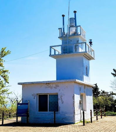
1960. Reactivated (inactive 1973-2019); focal plane 102 m (335 ft); white flash every 15 s. 9 m (30 ft) 2-stage square concrete tower rising from a 1-story concrete equipment building. Entire lighthouse is white. A photo is at right, a 2023 closeup, another photo and another closeup (3/4 the way down the page) are available, and Google has a satellite view. The light was extinguished in 1973 to prevent North Korean spies from reaching the island over the water. In November 2018 MOF announced it would be repairing and relighting the since improving relations with the north were allowing fishermen to return to the area. The relighting was announced in June 2019. Located in a park on the south point of the island. Site open, tower closed. KR-3721.1; Admiralty M4137.


North Breakwater Southwest Head Light, Yeonpyeong, March 2011
Naver.com Creative Commons photo by wooseokint1


Yeonpyeongdo Light, Yeonpyeong
Ongjin County photo


Daecheong Township Lighthouses
Located just off the southwestern corner of North Korea, Daecheong Township includes three islands, Socheongdo in the south, Daecheongdo in the center, and Baengnyeongdo in the north.
*** Socheongdo (Sochungdo, Sochong Do) (2)
Date unknown (station established 1908). Active; focal plane 83 m (272 ft); four white flashes every 40 s. 18 m (59 ft) round cylindrical concrete tower with lantern and gallery, rising from a 2-story staff building and visitor center. Lighthouse painted white. Fog siren (one blast every 45 s). A 2021 photo is at right, Oh Jun-ik has a photo, a closeup photo is available, and Google has a satellite view of the station. The original lighthouse was a 10 m (33 ft) round concrete tower. The lighthouse is described as housing a "marine culture hall." Socheongdo is a narrow island about 5 km (3 mi) long lying in the Yellow Sea at the extreme western point of South Korean sovereignty, about 30 km (20 mi) southwest of the North Korean mainland. The island is accessible by ferry from Incheon and tours are available. Located at the southwestern end of the island. Site and visitor center open, tower status unknown. . ARLHS SKR-047; KR-3725; Admiralty M4136; NGA 18104.
Seonjinpo Hang North Breakwater
Date unknown. Active; focal plane about 13 m (43 ft); red light, pattern unknown. Approx. 9 m (30 ft) round cylindrical concrete tower. Entire lighthouse is red. Dongsik Han has a 2021 photo, Yun Seok-yeong has a distant street view from the south breakwater and Google has a satellite view. Located on the north breakwater of Seonjinpo, the ferry port of Daecheongdo. May be accessible by walking the pier. Site status unknown. Admiralty M4135.9.
* Seonjinpo Hang South Breakwater
Date unknown. Active; focal plane about 13 m (43 ft); green light, pattern unknown. Approx. 9 m (30 ft) round cylindrical concrete tower. Entire lighthouse is white. Jeong Soon-gyu has a distant 2020 view, Yun Seok-yeong has a closeup street view, and Google has a satellite view. Located on the south breakwater of Seonjinpo. Accessible by walking the pier. Site open, tower closed. Admiralty M4135.91.
Yonggipo Hang Outer Breakwater South End
2012. Active; focal plane 13 m (43 ft); red flash every 5 s. 9 m (30 ft) round cylindrical concrete tower. Entire lighthouse is red. A photo of both breakwater lighthouses is available and Google has a satellite view. Located on the detached outer breakwater of Yonggipo, the ferry port of Baengnyeongdo. Accessible only by boat. Site and tower closed, but there's a good view from ferries arriving at the island. KR-3746; Admiralty M4135.8; NGA 18103.
Yonggipo Hang Inner Breakwater
2012. Active; focal plane 12 m (39 ft); green flash every 5 s. 9 m (30 ft) round cylindrical concrete tower. Entire lighthouse is white. A photo and a photo of both breakwater lighthouses are available, and Google has a satellite view. Located on the south breakwater of Yonggipo. Site and tower closed, but there's a good view from ferries arriving at the island. KR-3747; Admiralty M4135.85; NGA 18103.1.

Socheongdo Light, Socheongdo, September 2021
Google Maps photo by baeksun
* Yonggipo Hang
Date unknown. Inactive. Approx. 8 m (26 ft) round cylindrical concrete tower. SANGHWAN JEON has a 2022 photo, another photo is available, and Google has a satellite view. Located atop a promontory on the south side of Yonggipo harbor. Site open, and the tower appears to be open as well. ex-Admiralty F4134.

Information available on lost lighthouses:

Notable faux lighthouses:

Adjoining pages: North: Western North Korea | South: Dangjin and Pyeongtaek | Southwest: South Ongjin Islands

Return to the Lighthouse Directory index | Ratings key

Posted February 4, 2008. Checked and revised June 10, 2023. Lighthouses: 47. Site copyright 2023 Russ Rowlett and the University of North Carolina at Chapel Hill.