Lighthouses of Eastern Latvia

The Republic of Latvia (Latvijas in Latvian) faces west on the Baltic Sea and north on the Gulf of Rīga, an elliptical basin connected to the Baltic by the Irbe Strait. The western part of the country occupies a broad peninsula between the Gulf and the Baltic, an area that was included in the independent Duchy of Courland (Kurzeme in Latvian) during the 17th and 18th centuries. Rīga and the east coast of the Gulf were part of Swedish Livonia (Vidzeme in Latvian) during the 17th century. The Russian Empire annexed Swedish Livonia in 1710 and Courland in 1795. Latvia remained part of the Russian Empire until the end of World War I in 1918. After two decades of independence it was incorporated into the Soviet Union from 1940 to 1990. The older Latvian lighthouses are from the Russian Imperial period and some of the newer ones are of Soviet construction.

This page includes lighthouses of the Gulf of Rīga; lighthouses of the Baltic coast and Irbe Strait are described on the Western Latvia page. For local government Latvia is divided into 36 municipalities (novadi) and seven state cities (valstspilsētas).

Internationally, most locations on the coast of Latvia were known by their German names prior to World War I; these German names for the older lighthouses are shown in curly brackets {}.

The Latvian word for a lighthouse is bāka ("beacon"); zemesrags or the suffix -rags denotes a cape or headland, sala is an island, sekls is a shoal, līcis is a bay, šaurums is a strait, upe is a river, and osta is a port or harbor.

Lighthouses in Latvia are monitored and regulated by the Latvian Maritime Administration (Latvijas jūras administrācija) but are actually operated by the local port authorities in Liepāja, Ventspils and Rīga.

ARLHS numbers are from the ARLHS World List of Lights. UZ numbers are from the official Latvian light list, Ugunis un Zīmes. Light List numbers are from volume C of the Admiralty List of Lights & Fog Signals. U.S. NGA List numbers are from Publication 116.

General Sources
Lighthouse in Latvia
Information in English posted by the Latvian travel site Vietas.lv.
Online List of Lights - Latvia - Gulf of Riga
Photos by various photographers posted by Alexander Trabas. Some of the Latvian photos are by Andreas Kohler or Klaus Kern.
Ugunis un zīmes (List of Aids to Navigation)
The official Latvian light list is available in .pdf format.
Vikipēdija - Bākas Latvija
From the Latvian edition of Wikipedia, articles (in Latvian) on the major lighthouses, some with photos.
Leuchttürme in Lettland
Photos by Andreas Köhler.
Lighthouses in Latvia
Photos by various photographers available from Wikimedia.
World of Lighthouses - Latvia
Photos by various photographers available from Lightphotos.net.
Leuchttürme an der lettischen Küste
Photos of the major Latvian lighthouses taken in 2009 and posted by Bernd Claußen.
Latvian Lighthouses
Historic postcard images posted by Michel Forand.
Leuchttürme der ehemaligen deutschen Ostgebiete
Postcard views of historical German lighthouses on the Baltic coast, posted by Klaus Huelse.
GPSNauticalCharts
Navigation chart information for Latvia.
Navionics Charts
Navigation chart for Latvia.


Daugavgrīva Light, Rīga, July 2024
Instagram photo by Aleksandrs Petruhins

Roja Municipality Lighthouses
* Ģipka
1954. Active; focal plane 37 m (121 ft); white light, 2 s on, 4 s off. 30 m (98 ft) square cylindrical steel skeletal tower. The upper 12 m (39 ft) of the tower is enclosed by a large slatted daymark; the upper 2/3 of the daymark is painted red and the lower 1/3 white. A 2021 photo is at right, Claußen has a page for the lighthouse, Trabas has Kern's photo, another good photo is available, Rudīte Strēle has a 2023 photo, and Google has a satellite view and a distant street view. Located near the waterfront in Ģipka. Site open, tower closed. . ARLHS LAT-021; UZ-400; Admiralty C3486; NGA 12216.
Roja (2)
Around 2000? Active; focal plane 20 m (66 ft); continuous light, white, red or green depending on direction. 19 m (62 ft) triangular cylindrical skeletal tower, painted red. A small equipment shelter stands beside the tower. Trabas has Eckhard Meyer's photo, Köhler has a photo, a distant view is available, and Google has a satellite view. Located on the southeast side of the harbor entrance at Roja. Site and tower closed. UZ-390; Admiralty C3489; NGA 12224.
Roja Range Rear (2)
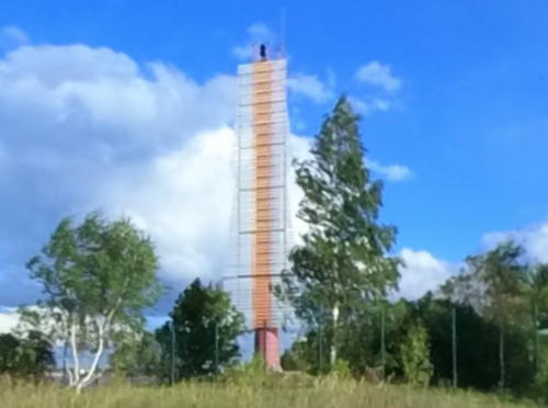
1930s(?). Inactive since around 1980(?). 16 m (52 ft) square skeletal tower, partially enclosed by a slatted daymark. Originally painted white, the tower is now red with rust. Bronius Sriubas rediscovered this abandoned tower in 2011 and contributed a photo; Google has a street view and a satellite view. Since 2011 the daymark slats have all or nearly all fallen off. Located on the south side of the harbor area. Site and tower closed. ARLHS LAT-013; ex-Admiralty C3488.1.
* Roja Range Rear (3)
Around 1980(?). Inactive since around 2000(?). 24 m (79 ft) concrete block monument, carrying a stork's nest in a 2015 photo. Google has a street view and a satellite view. The nature of the monument is not known. Located in central Roja, near the football stadium. Site open, tower closed. ex-Admiralty C3489.1.

Ģipka Light, Ģipka, July 2021
Google Maps photo by Deniss B.
Mērsrags {Markgrafen}
1875 (reconstructed in 1922). Active; focal plane 26 m (85 ft); white flash every 5 s. 19 m (62 ft) round cast iron tower, encased in concrete, with lantern and gallery, supported by eight broad buttresses. Lighthouse painted white with red trim. A 2021 photo by Ralfs Ančevs is at right, Vitalii Savuliak has a 2022 photo, Jānis Lapiņš has a 2021 closeup, Claußen has a page for the lighthouse, Trabas has Kern's photo, Köhler has a photo, Michel Forand has a 1923 postcard view, Niks Nikonorovs has a street view, and Google has an indistinct satellite view. This light guards a prominent cape about halfway between Cape Kolka and the city of Rīga. Prefabricated in France, the lighthouse was encased in concrete after being badly damaged during World War I. Huelse has a postcard view of the lighthouse before the reconstruction. Located about 6 km (4 mi) northeast of the town of Mērsrags. Site and tower closed (private property) as of fall 2018, although the lighthouse could be seen from a distance. . ARLHS LAT-009; UZ-375; Admiralty C3494; NGA 12228.
* Mērsrags Inner Range Front
Date unknown. Inactive since 2012. 10 m (33 ft) square pyramidal skeletal tower mounted on a square 1-story concrete equipment shelter. Tower painted red; the front of the tower carries a slatted daymark painted red with a white vertical stripe. Köhler has a photo, Google has a closeup 2011 street view, and Bing has a satellite view. Located on the north side of the harbor at the west end. Site open, tower closed. ex-UZ-365; ex-Admiralty C3495; ex-NGA 12229.
* Mērsrags Inner Range Rear
Date unknown. Inactive since 2012. 12 m (39 ft) square pyramidal skeletal tower mounted on concrete piers. Tower painted red; the front of the tower carries a slatted daymark painted red with a white vertical stripe. Köhler has a photo, Google has a distant street view, and Google has a satellite view. Located a short distance west of the front light. Site open, tower closed. ex-UZ-366; ex-Admiralty C3495.1; ex-NGA 12229.1.
Mērsrags Range Rear
Date unknown. Active; focal plane 17 m (56 ft); red light, 1.5 s on, 1.5 s off. 16 m (52 ft) square cylindrical skeletal tower painted black and carrying a slatted daymark painted red with a white vertical stripe. Trabas has Köhler's photo and Google has an indistinct satellite view. This is the entrance range for Mērsrags; the front light is on a shorter skeletal tower. The NGA number appears to be a mistake: 12231.1 was probably intended. Located on the waterfront on the south side of the harbor. Site and tower closed. UZ-352; Admiralty C3495.51; NGA 12331.1.

Mērsrags Light, Roja, October 2021
Instagram photo by Ralfs Ančevs

Engurē Municipality Lighthouses
* Engurē
1954. Active; focal plane 26 m (85 ft); two white flashes every 6 s. 19 m (62 ft) skeletal tower with a red and white daymark. Laura Elizabete Berzina has a 2022 closeup photo, Köhler has a photo, Zalais Nestabilais has a photo, a 2010 photo is available, Trabas has Eckhard Meyer's photo, and Google has a satellite view. Located on the north side of Engurē. Site open, tower closed. . ARLHS LAT-005; UZ-345; Admiralty C3501; NGA 12248.
Engurē Range Rear
Date unknown. Inactive but maintained as a daybeacon. 10 m (33 ft) square skeletal tower carrying a large slatted daymark painted white with a red vertical stripe. No photo available but Google has a satellite view. The front beacon is on a similar tower 5 m (16 ft) tall. Located at the rear of the harbor area in Engurē. Site and tower closed. UZ-341; Admiralty C3501.2.
* Ragaciems (2)
1960 (station establishment date unknown). Active; focal plane 37 m (121 ft); white light, 1 s on, 1 s off. 30 m (98 ft) tower, comprised of a square tower topped by a skeletal mast. A red slatted daymark surrounds all sides of the upper portion of the square tower. Trabas has Kern's photo, Köhler has a photo, and Google has an indistinct satellite view. The original beacon was a 5 m (17 ft) square concrete tower located a short distance southeast of the present light; a photo is available and Google has a satellite view. Located on a broadly rounded bend of the coast on the southwest shore of the Gulf of Rīga 1.2 km (3/4 mi) north of Ragaciems. Site open, tower closed. . ARLHS LAT-025; UZ-335; Admiralty C3502; NGA 12252.

Jūrmala City Lighthouse
* Buļļuciema (Buļļuciems, Lielupe)
1956. Active; focal plane 36 m (118 ft); white light, 1.5 s on, 3.5 s off. 28 m (92 ft) square cylindrical skeletal tower with gallery. The upper 3/4 of the tower is covered by a slatted daymark. Tower painted red with a white horizontal band. Trabas has Köhler's photo (also seen at right), Omer Reznik has a 2022 photo, Andrejs Tambergs has a 2017 photo, another 2017 photo is available, and Google has a distant satellite view. Located just off the beach at the end of 29th Street, about 13 km (8 mi) northwest of Rīga. Site open, tower closed. . ARLHS LAT-019; UZ-330; Admiralty C3503; NGA 12256.

Buļļuciema Light, Jūrmala, June 2018
photo copyright Andreas Köhler; used by permission

Rīga City: Daugava River West Bank Lighthouses
* Daugavgrīva (Bolderāja) {Dünamünde} (7?)
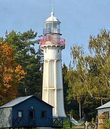
1957 (station established at least by 1721). Active; focal plane 37 m (121 ft); white flash every 2.5 s. 35 m (115 ft) round cylindrical concrete tower with lantern and gallery, painted with black and white horizontal bands; lantern painted black with a red roof. A 2024 photo by Aleksandrs Petruhins is at the top of this page, Trabas has Kern's photo, Claußen has a page for the lighthouse, Ezra Nuakin has a photo, and Google has a satellite view. A 2018 street view by Alexandr Pelsh shows this lighthouse, the front range light (see below), and the square 1-story keeper's house with cupola (a classic Russian design). Latvia's oldest light station is the landfall light for Rīga, the nation's capital and principal seaport. The station has a long and complex history. Lights were shown here from at least 1536 and a masonry tower was in regular service by 1721. A 30 m (98 ft) octagonal wood tower was built in 1819 and discontinued in 1854. A conical cast iron tower, installed in 1863, was destroyed in 1915 in World War I, and the concrete replacement built in 1921 was destroyed in 1944 in World War II. The 1863 Frenel lens was saved and is on display at the Ovīši lighthouse museum (see the Western Latvia page). Located on the west side of the entrance to the Daugava River and Rīga harbor. Direct road access is fenced, but the lighthouse can be reached by walking the beach. Site open; Claußen was able to climb the tower but we have no information on when it might be open to the public. . ARLHS LAT-004; UZ-075; Admiralty C3526; NGA 12272.
* [Daugava West Mole]
1998. Active; focal plane 11 m (36 ft); green flash every 3 s. 7 m (24 ft) round cylindrical tower with a small gallery but no lantern, painted white. Trabas has a photo, Sergej Pirtans has a 2019 closeup photo, Alexandr Pelsh has a closeup street view, and Google has a satellite view. Located at the end of the west mole at the Daugava River entrance. Apparently accessible by walking the mole. Site open, tower closed. ARLHS LAT-030; UZ-105; Admiralty C3528; NGA 12276.
* Daugavgrīva Range Front (2)
Date unknown. Active; focal plane 20 m (66 ft); red light, 2.5 s on, 2.5 s off, synchronized with the rear light. 15 m (49 ft) round cylindrical tower, painted red. The front of the tower is covered by a slatted daymark painted white with a red vertical stripe. A 2020 photo is at right, Köhler has a 2018 photo, Trabas has a photo, the light is seen in a 2018 street view by Alexandr Pelsh, and Google has a satellite view. This light replaced a square skeletal tower sometime after 2010. The range is the approach range for the Daugava River. Located close to the Daugavgrīva lighthouse. Site open, tower closed. UZ-080; Admiralty C3530; NGA 12280.
* Daugavgrīva Range Rear
Date unknown. Active; focal plane 29 m (95 ft); red light, 2.5 s on, 2.5 s off, synchronized with the front light. 26.5 m (87 ft) square cylindrical tower, painted red. The front of the tower is covered by a slatted daymark painted white with a red vertical stripe. Köhler has a photo, Trabas has a photo, and Google has a satellite view. Located on the west bank of the Daugava 590 m (0.37 mi) southeast of the front light. Site open, tower closed. UZ-081; Admiralty C3530.1; NGA 12284.

Daugavgrīva Range Front Light, Rīga, September 2020
Google Maps photo by Vadim R
Kara Osta (Kara Harbor) Range Rear
Date unknown. Active; focal plane 17 m (56 ft); green flash every 3.2 s. 16 m (52 ft) robust steel post painted red and carrying a large rectangular daymark painted white with a black vertical stripe. Trabas has a photo and Google has a satellite view. The front light is on a 12 m (39 ft) post. This range guides vessels into a modern commerical port on the west side of the Daugava River just inside the entrance. Located on the waterfront of the new port. Site and tower closed. UZ-134; Admiralty C3536.201; NGA 12297.1.
* Mangaļsala {Magnusholm} Beacon (Daugava East Mole) (1) (relocated to Rīga)
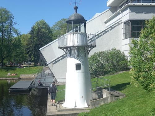
1863. Inactive since 1998. 6 m (20 ft) round cast iron tower with lantern and gallery, painted white. A 2024 photo is at right, a 2007 photo and a 2009 closeup are available, Uldis Bardins has a street view, and Google has a satellite view. This little lighthouse was formerly at the end of the east mole at the Daugava River entrance, opposite the Daugavgrīva lighthouse. Relocated to Rīga, the lighthouse stands in Kronvalda Park near the Free Port. Site open, tower closed. Owner/site manager: City of Rīga. ex-Admiralty C3528.

Rīga City: Daugava River East Bank Lighthouses
* Baltā-Baznicas (White Church) Range Rear
Date unknown. Active; focal plane 20 m (66 ft); orange light, 2 s on, 2 s off. 18 m (59 ft) square stone church steeple; the light is shown through a square window cut into the steeple. Sergej Voznuk has a photo, Alise Štāle has a 2018 photo, Trabas has a photo showing the light in action, and Google has a street view and a satellite view. This is a northbound (downstream) range guiding vessels leaving Rīga. The church is the historic Daugavgrīva White Church, a Lutheran church built in the late 1700s. There is a tradition that the church also served as a lighthouse, but more likely it was only a daybeacon until the range light was installed. Located on Atlantuas Iela at the intersection of Baltā-Baznicas Iela, in Mangaļi, on the east side of the Daugava. Site open, tower probably closed. Site manager: Daugavgrīvas Baltā Baznīca. ARLHS LAT-028; UZ-252; Admiralty C3547.2; NGA 12348.

1863 Mangaļsala Beacon, Rīga, May 2024
Google Maps photo by Александр
Rīnūži Range Rear
Date unknown. Active; focal plane 24 m (79 ft); green light occulting once every 5 s, synchronized with the front light. 22 m (72 ft) square skeletal tower painted red. The front of the tower carries a trapezoidal slatted daymark, painted red with a white vertical stripe. Trabas has a photo and Google has a street view and a satellite view. This is the entrance range for the river. Located in the harbor district near the foot of Zivyu Iela. Site and tower closed. UZ-101; Admiralty C3532.1; NGA 12336.
Rīnūži Range Front
Date unknown. Active; focal plane 16 m (52 ft); green light occulting once every 5 s, synchronized with the rear light. 13 m (43 ft) square skeletal tower painted red. The front of the tower carries a rectangular slatted daymark, painted red with a white vertical stripe. Trabas has a photo and Google has a satellite view. Located in the container terminal on the east bank of the river. Site and tower closed. UZ-100; Admiralty C3532; NGA 12332.
Mangaļu (Mangaļi) Range Front
Date unknown. Inactive since about 2016. 16 m (52 ft) square skeletal tower, painted red, carrying a large slatted daymark painted white with a black vertical stripe. Trabas has Arndt's photo and Google has a satellite view. This range guided vessels leaving Rīga. Located on the waterfront at Mangaļi. ex-UZ-185; ex-Admiralty C3540; ex-NGA 12320.
Mangaļu (Mangaļi) Range Rear
Date unknown. Inactive since about 2016. 22 m (72 ft) square skeletal tower, painted red, carrying a large slatted daymark painted white with a black vertical stripe. Trabas has Arndt's photo and Google has an indistinct satellite view. Located 252 m (275 yd) northwest of the front light. ex-UZ-186; ex-Admiralty C3540.1; ex-NGA 12324.
* [Mangaļsala Beacon (Daugava East Mole) (2)]
1998 (station established 1863). Active; focal plane 12 m (39 ft); red flash every 3 s. 7 m (24 ft) round cylindrical tower with a small gallery but no lantern, painted red. Viktor Vítek's photo is at right, Trabas has a photo, Maxim Kukuklinsky has a street view, and Google has a satellite view. Located at the end of the east mole at the Daugava River entrance, opposite the Daugavgrīva lighthouse. Apparently accessible by walking the mole. Site open, tower closed. . ARLHS LAT-031; UZ-104; Admiralty C3529; NGA 12288.

1998 Mangaļsala Beacon, Rīga, June 2019
Google Maps photo by Viktor Vítek

Saulkrasti Municipality Lighthouse
Ladiņi (Lilaste)
1954. Inactive but still listed officially as a daybeacon. 23 m (75 ft) square cylindrical skeletal tower, painted black. The upper half of the tower is partially enclosed by a slatted daymark painted with black and white horizontal bands. Köhler has a photo, a 2020 photo is available, and Google has an indistinct satellite view. Located on a ridge northeast of Lilaste, at the southeastern corner of the Gulf of Rīga. Site open, tower closed. ARLHS LAT-024; UZ-070; ex-Admiralty C3578.

Limbaži Municipality Lighthouses
Lāči
1954. Inactive since 2015 but still listed officially as a daybeacon. 23 m (75 ft) square cylindrical skeletal tower, painted black. Most of the tower is enclosed by a slatted daymark painted with red and white horizontal bands. Maksim Shlikov has a 2018 photo, Edmunds Folkmanis has the view from the beach, Māra Mikulāne has a 2019 photo, and Google has a satellite view of the station. Located on the coast south of the village of Liepupe. Site open, tower closed. . ARLHS LAT-007; UZ-045; ex-Admiralty C3583; ex-NGA 12428.
* Ķurmrags
Around 1920? Inactive. 14 m (46 ft) square skeletal tower mounted on a square pyramidal stone base. Normunds Ābelnīca has a 2022 photo and Gita Žibenko has a 2023 photo. Now in the surf, the abandoned lighthouse is is likely to be destroyed by the sea. A November 2007 photo shows the tower leaning ominously, but Alexey Melsitov's August 2012 photo, Alex Bondarenko's 2016 photo and Maksim Shlikov's August 2018 photo all show it still standing. A 2021 photo shows an increased lean. Google has a satellite view. The light was in service as late as the 1980s. Located at the village of Ķurmrags on the east coast of the Gulf of Rīga about 40 km (25 mi) south of Ainaži. . ex-Admiralty C3584.
* Vitrupe (Grīntāla) {Witterbeck}
Date unknown. Active; focal plane 34 m (111 ft); red flash every 4 s. 21 m (69 ft) square cylindrical skeletal tower with gallery and a small lantern, painted red. The tower is enclosed by a slatted daymark, painted white with a broad black band at the top. A 2007 photo and a closeup are available, Trabas has Kern's photo, Köhler has a photo, and Google has a distant street view and a distant satellite view. NGA lists the light as "Grintals." Located on a headland near Vitrupe, about 25 km (15 mi) south of Ainaži. The entrance is unmarked. Site open, tower closed. . ARLHS LAT-022; UZ-040; Admiralty C3585; NGA 12436.
* Salacgrīva {Salismünd} (2)
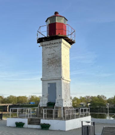
1933 (station established 1925). Inactive since around 1970(?). 8.5 m (28 ft) square cylindrical concrete tower with lantern and gallery. Lighthouse painted white, lantern red. A 2024 photo is at right, a 2022 closeup is available, Krists Grinbergs has a 2021 photo, Marcin Szala has a 2011 photo, Google has a street view and a satellite view. This lighthouse was probably replaced by the range lights. It was in service in 1967 but was discontinued before 1984. Salacgrīva is a port at the mouth (grīva) of the Salaca (Salis) River. Located on the waterfront of Salacgrīva. Site open, tower closed. . ARLHS LAT-034; ex-Admiralty C3586.

Salacgrīva Light, Salacgrīva, May 2024
Google Maps photo by Sasha K
* Salacgrīva {Salismünd} Range Rear
Date unknown. Active; focal plane 24 m (79 ft); red light, 2 s on, 2 s off. 18 m (59 ft) square skeletal tower, painted red. The front of the tower carries a slatted daymark painted white with a black vertical stripe. Trabas has Eckhard Meyer's photo, Google has a closeup street view, and the shadow of the tower is seen in Google's satellite view. The front light is on a 10 m (33 ft) skeletal tower 200 m (660 ft) west southwest. Located near the waterftont of Salacgrīva. Site open, tower closed. UZ-011; Admiralty C3587.1; NGA 12444.
* Kuiviži (Randgala) Range Rear
Date unknown. Active; focal plane 18 m (59 ft); two continuous red lights arranged vertically. 17 m (56 ft) slender square skeletal tower with a pyramidal base, painted black and carrying a rectangular daymark painted white with a black vertical band. Trabas has Köhler's photo, Google has a street view, and Bing has an indistinct satellite view. The front light is on a post 9 m (30 ft) tall. Located off highway A1 about 3 km (2 mi) north of Salacgrīva. Site open, tower closed. UZ-006; Admiralty C3588.1.
* [Ainaži Breakwater (lantern)]
1908. Inactive at least since 1986, when the lighthouse collapsed into the sea. The lantern was salvaged and in 1991 it was restored and mounted on display at the entrance to the Museum of the Ainaži Naval School, about 100 m (110 yd) southwest of the present lighthouse (next entry). Vladimir Bryunin has a 2022 photo, Wikimapia has photos, Google has a good street view, and Bing has an indistinct satellite view. Site open, tower closed.
* Ainaži {Gainash, Hainasch} (2)
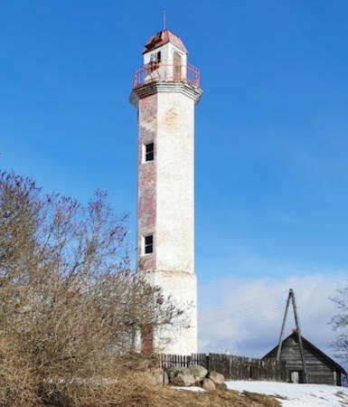
Date unknown (1930?) (station established 1920s). Active; focal plane 22 m (72 ft); white light, 2 s on, 2 s off. 18 m (59 ft) octagonal masonry tower with lantern and gallery, painted white with an orange vertical stripe. 1-1/2 story wood keeper's house collapsing into ruins. Maige Õunpuu's 2023 photo is at right, Vladimir Tkachenkov has a good photo, Matīss Vecvagaris has a 2021 closeup, Laima Gūtmane has a 2011 photo, the Vietas guide has photos, Trabas has Kern's photo, and Google has a 2024 street view and a satellite view. The light was originally the rear light of a range, but the front light has been discontinued. Located at the intersection of Barona and Nakotnes streets in Ainaži, a town on the east coast of the Gulf of Rīga close to the Estonian border, about 125 km (80 mi) north of Rīga. Site open, tower closed. . ARLHS LAT-001; UZ-001; Admiralty C3590; NGA 12448.

Ainaži Light, Salacgrīva, March 2023
Google Maps photo by Maige Õunpuu

Information available on lost lighthouses:

Notable faux lighthouses:

Adjoining pages: North: Southwestern Estonia | West: Western Latvia

Return to the Lighthouse Directory index | Ratings key

Posted April 25, 2005. Checked and revised July 28, 2024. Lighthouses: 30. Site copyright 2024 Russ Rowlett and the University of North Carolina at Chapel Hill.