Lighthouses of Malta

The Republic of Malta is a small and densely populated island nation located in the center of the Mediterranean Sea about 90 km (55 mi) south of Capo Passero, Sicily. Malta is also the name of the largest island of the group; Għawdex (Gozo), the other major island, lies just to the northwest. The islands have a long and colorful history. From 1530 to 1798 they were independent under the rule of a Catholic military order called the Knights of St. John. Napolean captured the islands in 1798 but British troops evicted the French in 1800. Malta became a British colony in 1814. After 150 years of British rule the country resumed its independence in 1964 and joined the European Union in 2004.

The Maltese language is spoken in the islands in addition to English and Italian. Maltese is related to Arabic but it is written in the Latin alphabet. The Maltese word for a lighthouse is fanal; gżira is an island, bajja is a bay, ponta is a point of land, and port is a harbor.

Lighthouses in Malta are maintained and operated by Transport Malta Maritime.

ARLHS numbers are from the ARLHS World List of Lights. Admiralty numbers are from volume E of the Admiralty List of Lights & Fog Signals. U.S. NGA List numbers are from Publication 113.

General Sources
Online List of Lights - Malta and Adjacent Islands
Photos by various photographers posted by Alexander Trabas. Currently the photos from Malta are all by Capt. Peter Mosselberger ("Capt. Peter").
Sentinelles des Mers - Autres Pays
Photos and text by Guy Détienne. The Malta entries are halfway down the page.
Lighthouses in Malta
Photos by various photographers available from Wikimedia.
World of Lighthouses - Malta
Photos by various photographers available from Lightphotos.net.
Maltese History and Heritage: Lighthouses
Much of the text for this web page is taken without permission or attribution from this Directory or from the Lighthouse Digest directory. However, the page does have a fine collection of photos.
Leuchttürme Italiens und Maltas auf historischen Postkarten
Historic postcard images posted by Klaus Huelse; Maltese lighthouses are near the bottom of the page.
GPSNavigationCharts
Navigation chart information for Malta.
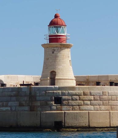

Ricasoli Light, Valletta, August 2022
Google Maps photo by Daniele Zanolari
Għawdex (Gozo) Lighthouses
Gozo is an elliptical island about 14 km (9 mi) long and 5 km (3 mi) wide located roughly 5 km (3 mi) northwest of the main island of Malta. The island is lightly populated with a population of about 31,000.

*
Ġurdan (Giordan, Gordan, Gurdan)
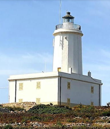
1853 (station established around 1650). Active; focal plane 180 m (591 ft); white flash every 7.5 s. 22 m (72 ft) round stone tower with lantern and gallery, rising from a 2-story stone keeper's house. Tower and lantern painted white; the house is unpainted. Stephen Camilleri's 2021 photo is at right, Trabas has Capt. Peter's photo, Wikimedia has several photos, Aldo Cauchi Savona has a photo, Lightphotos.net has a closeup and a distant view, Matteo Morotti has a 2016 street view, Huelse has a historic postcard view, and Google has a satellite view. This lighthouse is the landfall light for ships arriving in Malta from the west. We do not have any account of the early history of the station. Automated in 1994, the lighthouse is now the principal Global Atmospheric Watch station for the Central Mediterranean. A €200,000 project to restore the lighthouse as a tourist attraction began in early 2018. Michael Kessler has a May 2019 photo and Attilio Scarioni has a February 2020 photo showing this work in progress and Camilleri's photo at right shows the results. Located on Ġordan Hill in Għasri, near the northwestern tip of Għawdex, 800 m (1/2 mi) from the brink of a sheer cliff that drops directly into the sea. Accessible by road. Site open, tower closed. . ARLHS MLT-003; Admiralty E2050; NGA 10504.
Port Ta L-Imġarr North Breakwater
Date unknown. Active; focal plane about 7 m (23 ft); green flash every 5 s. 5 m (17 ft) round strongly conical concrete tower mounted on a round base. Lighthouse painted with green and white horizontal bands. Trabas has a photo by Capt. Peter, Lightphotos.net has a photo of the light being passed by an interisland ferry, and Google has a sea view and a satellite view. Located at the end of the north breakwater of Mġarr, the port at the east end of Għawdex. Site and tower closed, but there's a good view from ferries arriving from Malta. Admiralty E2051.2; NGA 10512.
Port Ta L-Imġarr Main Breakwater
Date unknown. Active; focal plane about 8 m (26 ft); red flash every 4 s. 5 m (17 ft) round strongly conical concrete tower mounted on a round base. Lighthouse painted with red and white horizontal bands. Trabas has a photo by Capt. Peter, a 2009 closeup photo is available, David Farinic has a closeup 2015 street view, Lightphotos.net has a view from the sea, and Google has a satellite view. Located at the end of the south (main) breakwater of Mġarr, the port at the east end of Għawdex. Site status unknown; it may be possible to walk the breakwater. There's a good view from ferries arriving from Malta. Admiralty E2051; NGA 10508.

Ġordan Light, Għasri, April 2021
Google Maps photo by Stephen Camilleri

Island of Malta Lighthouses
The main Island of Malta is elliptical, 27 km (17 mi) long and 14.5 km (9 mi) wide. It has a population of about 500,000.

* Ponta tac-Cirkewwa (1)
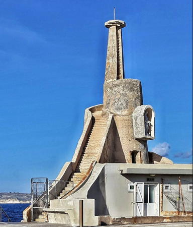
Date unknown. Inactive. Approx. 11 m (36 ft) octagonal concrete column atop a round concrete tower mounted on a round stone base. A statue of the Virgin Mary is placed in an alcove above the entrance to the tower. The lighthouse is unpainted. Mathias Doering's 2018 photo is at right, Karl Esch has a 2012 photo, Lightphotos.net has a good photo, George Saguna has a 2016 street view, and Google has a satellite view. The active light (focal plane 10 m (33 ft); red flash every 2 s) is on a short mast at the end of the adjoining breakwater; Trabas has Capt. Peter's photo, and Lightphotos.net has a closeup. Cirkewwa, at the western tip of the island of Malta, is the terminal for ferries to Mġarr, Għawdex (Gozo). Located on the quay at Cirkewwa. Site open, tower closed. . ARLHS MLT-008. Active light: Admiralty E2055.5; NGA 10524.
#Portomaso Marina
Date unknown (recent). Removed around 2019. This light, not listed by the Admiralty, was a 6 m (20 ft) locomotive-style lamp atop the domed roof of a small octagonal 1-story marina control room, mounted on 8 concrete piles. A 2007 photo is available, also a second 2007 photo, and Andry Ravelojaona has a 2018 street view. Google's satellite view confirms the removal. This light marked the entrance to the marina of an upscale resort development; that function now falls to a post light on the opposite breakwater. Located on the Ponta ta'Spinola, on the north side of the island of Malta and the west side of St. Julian's Bay about 2.5 km (1.5 mi) northwest of Sliema. Site open, tower closed. Site manager: Portomaso Marina.
* Valletta (Fort St. Elmo) (4?)
2013 (station established 1851). Active; focal plane 49 m (161 ft); three white flashes every 15 s. This light has been at various locations in recent years; apparently it is now mounted directly atop the historic fort. Trabas has Capt. Peter's photo, Guy Detienne has a distant view (click on the photo in the bottom right corner of the page), and the tiny light is centered in Google's satellite view. Previously the light was on an approx. 6 m (20 ft) concrete pylon, mounted at the highest point of the fortress. Before that the light was on an approx. 10 m (33 ft) square steel skeletal tower with gallery; Lightphotos.net has a 2006 distant view. The Admiralty described the light as "temporarily unreliable" in January 2013. A historic view of the original lighthouse is available and Huelse has a distant postcard view. Dominating the harbor of Valletta, Malta's capital, Fort St. Elmo dates from the 16th century. Most of the fort is now a museum, and the rest houses Malta's police academy. Located at the tip of the peninsula separating the Grand Harbour from the Marsamxett Harbour in Valletta. Site open, tower closed. ARLHS MLT-007; Admiralty E2061.5; NGA 10544.

Cirkewwa Light, Cirkewwa, December 2018
Google Maps photo by Mathias Doering
St. Elmo (Grand Harbour West Breakwater)
1908 (?). Active; focal plane 16 m (52 ft); quick-flashing green light. 14 m (46 ft) tapered stone tower with lantern and gallery. Tower unpainted, lantern painted green. Trabas has Capt. Peter's excellent closeup, Lightphotos.net has a good photo, Gillian Thomas has a 2018 photo, Tom Gates's photo shows this lighthouse in the distance, and Google has a satellite view. The two breakwater lighthouses stood without their lanterns for decades, but in 2012 replicas of the original lanterns were installed. Martin Kubik has a 2008 photo showing the tower without the present lantern. The West Breakwater is detached but joined to the mainland by a bridge seen in David Micallef's photo. It is walkable, but it may take some local knowledge to find a way to the bridge below the ramparts of Fort St. Elmo. Located at the end of the breakwater on the west side of the entrance to the Grand Harbour of Valletta. Accessible only by boat (the breakwater is detached from shore). There are good views from ferries arriving in Valletta. Site and tower closed. ARLHS MLT-002; Admiralty E2062; NGA 10548.
* Ricasoli (Grand Harbour East Breakwater)
1908. Active; focal plane 11 m (36 ft); quick-flashing red light. 9 m (30 ft) tapered stone tower with lantern and gallery. Tower unpainted, lantern painted red. A 2022 photo by Daniele Zanolari is at the top of this page, Trabas has Capt. Peter's excellent closeup, Tom Gates has a photo, Lightphotos.net has a good photo, Roman Vaytsulevich has a view from the sea, David Micallef has a 2016 street view, and Google has a satellite view. The two breakwater lighthouses stood without their lanterns for decades, but in 2012 replicas of the original lanterns were installed. Huelse has a historic postcard view showing the original lantern. Located at the end of the breakwater on the east side of the entrance to the Grand Harbour of Valletta, adjacent to Fort Ricasoli. Accessible by walking the pier, and there are good views from ferries arriving in Valletta. Site open, tower closed. . ARLHS MLT-004; Admiralty E2064; NGA 10552.
* Delimara Point (Il-Kalanka) (1)
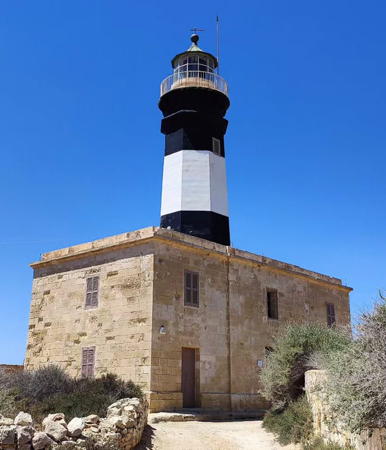
1855. Reactivated (inactive from about 1990 to 2014); focal plane 35 m (115 ft); two white flashes every 12 s. Approx. 22 m (72 ft) octagonal stone tower with lantern and gallery, rising from a 2-story stone keeper's house. Lighthouse painted black with a white horizontal band. The house is unpainted. Francesca Cirillo's 2024 photo is at right, a 2021 photo is available, Friedrich Klett has a closeup 2023 drone view, Paul Tickle has a 2011 photo, Salvatore Mugliett has a 2008 closeup, Huelse has a postcard view, and Google has a street view and a satellite view. The Delimara Point Light served as the landfall light for ships arriving in Malta from the east. The lighthouse also marks the north side of the entrance to the fishing port of Marsaxlokk. The lighthouse deteriorated badly after being deactivated; H.H. Schueller's 2005 photo shows its poor condition. In March 2006 the Malta Maritime Authority donated the inactive lighthouse to the National Trust of Malta (Din l-Art Ħelwa), and in 2007-08 the Trust completed a restoration of the building. The lantern and Fresnel lens were restored in a second phase of the project, which was underway in late 2011 and was completed in 2014. In 2015 two apartments in the keeper's house were opened for vacation rental. Located at the southeastern tip of Malta, about 3 km (2 mi) southeast of Marsaxlokk. Site open, tower closed. Site manager: National Trust of Malta (Din l-Art Ħelwa) (Delimara Lighthouse). . ARLHS MLT-001; Admiralty E2070; NGA 10564.
* Delimara Point (Il-Kalanka) (2)
About 1990. Inactive since about 2013-14. 2-story masonry building topped by communications gear. Trabas has Rainer Arndt's closeup photo, and the light can be seen at the right in H.H. Schueller's 2005 photo. Google has a street view and a satellite view. This building carried the light until the historic lighthouse was restored (previous entry). Located a short distance south of the historic lighthouse. Site open, tower closed.

Delimara Point Light, Marsaxlokk, July 2024
Instagram photo by Francesca Cirillo

Information available on lost lighthouses:

Notable faux lighthouses:

Adjoining page: North: Eastern Sicily

Return to the Lighthouse Directory index | Ratings key

Posted July 26, 2006. Checked and revised March 14, 2025. Lighthouses: 10. Site copyright 2025 Russ Rowlett and the University of North Carolina at Chapel Hill.