Lighthouses of Mexico: South Coast

Mexico, officially the United Mexican States (Estados Unidos Mexicanos or EUM), is the second largest country of Latin America and the largest Spanish-speaking nation in the world. With an east coast on the Gulf of Mexico and Caribbean Sea and a long west coast on the Pacific Ocean it has by far the longest coastline in Latin America and, as a result, the largest number of lighthouses.

For three centuries what is now Mexico was the central part of the Viceroyalty of New Spain. After achieving independence from Spain in 1821 Mexico suffered several decades of political upheaval and the loss of its northern territories, including Texas, New Mexico, and California, to the expansion of the United States. After the sale of some additional territory to the U.S. Mexico assumed its present borders in 1853.

Mexico is a federal union of 31 states (estados) plus the capital district, and the states are subdivided into county-level units called municipalities (municipios). This page lists of lighthouses of the south coast of Mexico in the states of Chiapas, Oaxaca and Guerrero. This coast includes the famous resort city of Acapulco and many smaller ports.

In Spanish the word for a lighthouse is faro, baliza is a beacon, isla is an island, cabo is a cape, punta is a promontory or point of land, péñon is a rock, arrecife is a reef, bahía is a bay, ría is an estuary or inlet, estrecho is a strait, río is a river, and puerto is a port or harbor.

Mexican lighthouses are managed by the Port Captains and Maritime Affairs Unit (Unidad de Capitanías de Puerto y Asuntos Marítimos, UNICAPAM). Many of the larger light stations are staffed by resident civilian keepers.

ARLHS numbers are from the ARLHS World List of Lights. CF numbers are from the Mexican Cuaderno de Faros (Handbook of Lighthouses). Admiralty numbers are from volume G of the Admiralty List of Lights & Fog Signals. U.S. NGA numbers are from Publication 111.

General Sources
Online List of Lights - Mexico - West Coast
Photos by various photographers posted by Alexander Trabas. Many of the photos are by Jim Smith or Capt. Peter Mosselberger ("Capt. Peter").
Lighthouses in Mexico
Photos by various photographers available from Wikimedia.
World of Lighthouses - Mexico
Photos by various photographers available from Lightphotos.net.
Leuchttürme Mittelamerikas und der Karibik auf historischen Postkarten
Historic postcard images posted by Klaus Huelse.
Cuaderno de Faros
The Mexican light list can be downloaded in two volumes, Atlantic and Pacific.
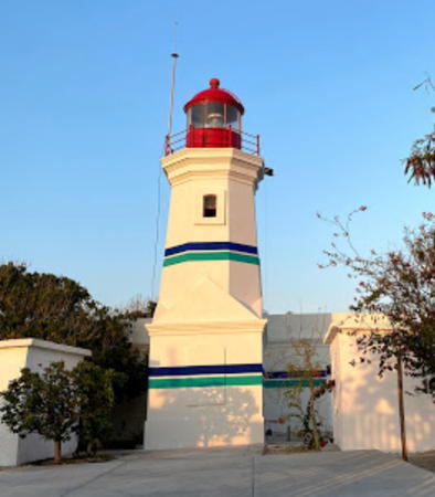

Puerto Ángel Light, Oaxaca, March 2021
Google Maps photo by Belén Ceballos

Chiapas Lighthouses

Eastern Chiapas (Tapachula Area) Lighthouses
This region is called Soconusco. In the early years of Mexican independence its status is uncertain, with many residents preferring union with Guatemala. It was not firmly a part of Mexico until 1842, and the present border with Guatemala was finally established by a treaty in 1882.
* El Gancho Range Front
Date unknown. Active; focal plane 21 m (69 ft); white flash every 3 s. 18 m (59 ft) round cylindrical white concrete tower with lantern and gallery. Google has the street view at right and a satellite view. Located on the south side of El Gancho, a town about 4 km (2.5 mi) northwest of the Guatamala border. Site open, tower closed. CF-07-090.1; Admiralty G3404; NGA 15350.
* El Gancho Range Rear
Date unknown. Active; focal plane 25 m (82 ft); white light, 1 s on, 1 s off. 24 m (79 ft) square white concrete skeletal tower with lantern, gallery, and a large central cylinder. Google has a street view and a satellite view. Located about 1.2 km (3/4 mi) east northeast of the front light. Site open, tower closed. CF-07-095; Admiralty G3404.1; NGA 15351.
* Puerto Chiapas (Puerto Madero) Range Front
Date unknown. Active; focal plane 12 m (39 ft); white flash every 3 s. 12.5 m (41 ft) square pyramidal skeletal tower, carrying a red and white slatted daymark. Trabas has Smith's photo, Lightphotos.net has Robert English's photo of the two range lights and Google has a satellite view. The name of this port, part of the municipality of Tapachula, was changed from Puerto Madero to Puerto Chiapas in 2005 when the port was upgraded to handle bulk cargo and cruise ships. This is the approach range for the port. Located on the east side of the entrance to the harbor of Puerto Chiapas. Site open, tower closed. CF-07-105; Admiralty G3424.3; NGA 15331.
* Puerto Chiapas (Puerto Madero) Range Rear
Date unknown. Active; focal plane 17 m (56 ft); white light, 1 s on, 1 s off. 17 m (56 ft) square pyramidal skeletal tower, carrying a red and white slatted daymark. Trabas has Smith's photo, Lightphotos.net has Robert English's photo of the two range lights and Google has a satellite view. Located 74 m (243 ft) northeast of the front light. Site open, tower closed. CF-07-110; Admiralty G3424.31; NGA 15331.1.

Range Front Light, El Gancho, February 2013
Google Maps street view
* Puerto Chiapas (Puerto Madero) Muelle de Pesca Range Rear
Date unknown. Active; focal plane 20 m (66 ft); white light, 1 s on, 1 s off. 18 m (59 ft) square pyramidal skeletal tower, carrying a slatted daymark and mounted on a square concrete base. Trabas has Smith's photo and Google has a street view and a satellite view. The front light is on a 10 m (33 ft) skeletal tower 250 m (820 ft) west. Located east of the fishing harbor area of Puerto Chiapas. Site open, tower closed. CF-07-070.1; Admiralty G3424.81; NGA 15342.
Puerto Chiapas (Puerto Madero) Entrance Range Front
Date unknown. Active; focal plane about 19 m (62 ft); white flash every 3 s. 15 m (49 ft) square pyramidal skeletal tower, apparently mounted on a square concrete base. Trabas has Smith's photo and Google has a street view and a satellite view. Located northeast of the harbor area of Puerto Chiapas. Site open, tower closed. CF-07-045; Admiralty G3424.4; NGA 15336.
* Puerto Chiapas (Puerto Madero) Entrance Range Rear
Date unknown. Active; focal plane 24 m (79 ft); white light, 1 s on, 1 s off. 21 m (69 ft) square pyramidal skeletal tower, apparently mounted on a square concrete base. Trabas has Smith's photo and Google has a street view and a satellite view. Located 250 m (820 ft) northeast of the front light. Site open, tower closed. CF-07-045.1; Admiralty G3424.41; NGA 15340.
* Puerto Chiapas (Puerto Madero) Muelle Fiscal Range Front (2)
Date unknown. Active; focal plane 18 m (59 ft); white flash every 3 s. 19 m (62 ft) square pyramidal skeletal tower, apparently mounted on a square concrete base. Trabas has Smith's photo and Google has a satellite view. NGA formerly listed a 10 m (33 ft) tower. Located north of the main harbor area of Puerto Chiapas. Site open, tower closed. CF-07-075; Admiralty G3424.6; NGA 15345.
* Puerto Chiapas (Puerto Madero) Muelle Fiscal Range Rear (2)
Date unknown. Active; focal plane 24 m (79 ft); white light, 1 s on, 1 s off. 24 m (79 ft) square pyramidal skeletal tower, apparently mounted on a square concrete base. Trabas has Smith's photo of the two range lights and Google has a satellite view. NGA formerly listed a 16 m (52 ft) tower. Located 270 m (885 ft) north of the front light. Site open, tower closed. CF-07-075.1; Admiralty G3424.61; NGA 15346.
* Puerto Chiapas (Puerto Madero, Faro San Benito)
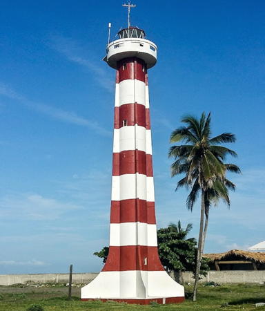
Date unknown. Active; focal plane 24 m (79 ft); white flash every 5 s. 22 m (74 ft) round cylindrical tower with lantern and gallery, painted with red and white horizontal bands. Lantern painted white with a red roof. Francisco Andrade has a 2017 photo (also seen at right), Trabas has Smith's closeup photo, Bob Swanson has a 2010 photo, Lightphotos.net has Robert English's photo, and Google has a street view and a satellite view. Located on the west side of the harbor entrance of Puerto Chiapas. Site open, tower closed. ARLHS MEX-045; CF-07-025; Admiralty G3424; NGA 15324.

Puerto Chiapas Light, Puerto Chiapas, September 2017
Google Maps photo by Francisco Andrade

Western Chiapas (Tonalá Area) Lighthouses
Barra San Juan (Acapetahua)
Date unknown. Active; focal plane 14 m (46 ft); four white flashes every 16 s. 12 m (39 ft) round white cylindrical tower topped by a short skeletal tower. A distant 2020 drone view is available and and Google has a satellite view. Located behind the beach about 40 km (25 mi) southeast of Puerto Arista. Site status unknown. ARLHS MEX-099; CF-07-015; Admiralty G3425; NGA 15316.
Santa Cruz (Pijijiapan, Palo Blanco)
Date unknown. Active; focal plane 14 m (46 ft); three white flashes every 12 s. 12 m (39 ft) round cylindrical white concrete tower topped by a square skeletal tower with a slatted daymark painted white. The Cuaderno has a small photo and Google has a satellite view. Located behind the beach at Pijijiapan. Site status unknown. ARLHS MEX-132; CF-07-010; Admiralty G3426; NGA 15312.
* Puerto Arista (2)
2019 (station established 1892). Active; focal plane 26 m (79 ft); two white flashes every 10 s. 26 m (79 ft) white concrete tower with lantern and gallery. Lighthouse painted white, lantern red. A photo is at right and Google has a 2023 street view and a satellite view. The original lighthouse was a 22 m (74 ft) round cylindrical concrete tower with lantern, three galleries, and four buttresses, adjoining a 1-story keeper's house. The lighthouse was heavily damaged by the Chiapas Earthquake of 7 September 2017, leaving the tower with a lean of 6 meters to the west. As a result the lighthouse was demolished in 2018. Alejandro Linares Garcia has a photo of the older lighthouse, Wikimedia has additional photos, and Google has a 2012 street view. The three galleries recorded two successive extensions of the tower. The buttresses were added with the last extension. In older and quieter times the keeper also served as the town mailman. Puerto Arista is a beach resort in the municipality of Tonalá; despite its name it has no significant port facilities. Located on the main street in Puerto Arista. Site open, tower closed. ARLHS MEX-042; CF-07-005.1; Admiralty G3428; NGA 15308.
[Paredón]
Date unknown. Active; focal plane 11 m (36 ft); three white flashes every 12 s. 10 m (33 ft) white concrete post. Google has a 2023 street view but the small light is inconspicuous in Google's satellite view. Paredón, on the Bahía Mar Muerto (Dead Sea Lagoon), is the largest fishing port of Chiapas, known for its shrimp. Located just north of the foot of the Avenida Pescadores in Paredón. Site status unknown. CF-07-005; Admiralty G3428.5; NGA 15306.


New Puerto Arista Light, Puerto Arista, December 2019
Google Maps photo by MR. HUITZTAPACALA

Oaxaca Lighthouses

Istmo Region (Salina Cruz Area) Lighthouses
This section of the coastline faces the Gulf of Tehuantepec, which is not so much a gulf as a broad bight of the Pacific Ocean. East of Salina Cruz the coastline is low with barrier islands fronting large lagoons, the Bahía Mar Muerto in the east and the Laguna Inferior and Laguna Superior to the west.

La Soledad
Date unknown. Active; focal plane 15 m (49 ft); white flash every 6 s. 12 m (39 ft) round cylindrical tower with gallery, white with red bands. Entire lighthouse is white. The Cuaderno has a small photo and Google has a satellite view. The Cuaderno has a different location listed for this light; Google's satellite view shows only a small structure at that location. Located just off the barrier beach about 30 km (19 mi) west of Paredón. Best accessed by boat across the lagoon. Site open, tower closed. ARLHS MEX-115; CF-20-110; Admiralty G3429; NGA 15304.
La Chichi
Date unknown. Active; focal plane 15 m (49 ft); two white flashes every 10 s. 12 m (39 ft) round cylindrical concrete tower with gallery. Entire lighthouse is white. The Cuaderno has a small photo and Google has a satellite view. Located just off the barrier beach about 35 km (22 mi) east of the entrance to the Laguna Inferior. Best accessed by boat across the lagoon. Site open, tower closed. ARLHS MEX-114; CF-20-105; Admiralty G3430; NGA 15300.
San Dionisio del Mar (2)
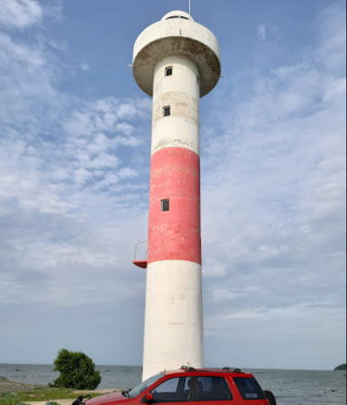
Date unknown. Active; focal plane 17 m (55 ft); four white flashes every 16 s. 15 m (49 ft) round cylindrical concrete tower with lantern and gallery. The lighthouse is white with one red horizontal band. A 2023 photo by Roberto Tannos is at right, Sergio Colin has a 2017 photo, Antonio Mirandismo has a more distant view, and Google has a satellite view. The original lighthouse was 10 m (33 ft) tall. Located at the point of a spit projecting into the Laguna Inferior about 10 km (6 mi) south of San Dionisio del Mar. Accessible only by boat. Site open, tower closed. ARLHS MEX-130; CF-20-100; Admiralty G3431.5; NGA 15296.
San Francisco del Mar
Date unknown. Active; focal plane 17 m (56 ft); three white flashes every 12 s. 12 m (39 ft) round cylindrical tower, painted with red and yellow spiral bands. The Cuaderno has a small photo and Google has a satellite view. The lighthouse guides vessels toward the entrance to the Laguna Inferior. Located on a long sand spit about 40 km (25 mi) east of Salina Cruz. Site status unknown. ARLHS MEX-073; CF-20-095; Admiralty G3431; NGA 15292.

San Dionisio del Mar Light, Oaxaca, July 2023
Google Maps photo by Roberto Tannos
* Punta La Ventosa (Punta Cortés, Faro de Cortés) (3)
Date unknown. Active; focal plane 30 m (98 ft); two white flashes every 10 s. 8 m (26 ft) hexagonal concrete pillar painted with red and white vertical stripes. Luis Nolasco has a 2021 photo and Google has an indistinct satellite view. This light replaced a square cylindrical rubblestone tower with lantern and gallery seen in a 2017 Google closeup street view and a 2008 distant view from the sea. Gilberto Morales Molina has a 2020 photo of the newest tower standing next to the remains of a smaller stone beacon representing the original Faro de Cortés said to have been built in the 16th century. The lighthouse is named for the explorer and conqueror Hernán Cortés, who arrived here in 1527. Located on a promontory about 800 m (1/2 mi) south of La Ventosa and 5 km (3 mi) east of Salina Cruz. Site open, tower closed. Operator: ASIPONA Salina Cruz. . CF-20-060.1; Admiralty G3431.7; NGA 15290.5.
* Salina Cruz Range Front
Date unknown. Active; focal plane 59 m (194 ft); white flash every 3 s. 13 m (43 ft) square pyramidal skeletal tower painted white and carrying a triangular red slatted daymark, mounted on a square concrete equipment shelter. Google has a 2024 street view and an indistinct satellite view. The Cuaderno says the focal plane is 2.5 m and NGA says it is 74 m; the 59 m figure comes from a 2019 Admiralty Notice to Mariners. Located on heights above the harbor of Salina Cruz. Site open, tower closed. Operator: ASIPONA Salina Cruz. CF-20-075; Admiralty G3435; NGA 15284.
Salina Cruz Range Rear
Date unknown. Active; focal plane 67 m (220 ft); white light, 1 s on, 1 s off. 13 m (43 ft) square pyramidal skeletal tower painted white and carrying a triangular red slatted daymark, mounted on a square concrete equipment shelter. Google has a 2022 street view but the light is hard to see in Google's satellite view. Located 280 m (306 yd) north northwest of the front light. Site status unknown. Operator: ASIPONA Salina Cruz. CF-20-080; Admiralty G3435.1; NGA 15288.
* Morro de Salinas (Salina Cruz)
1896. Active; focal plane 83 m (272 ft); white flash every 8 s. 14 m (46 ft) octagonal masonry tower with 1-story stone keeper's house. Lighthouse painted white, lantern red; the tower also carries the logo of the local port authority. Part of Google's 2024 street view is at right, Trabas has Hendrik Martin Porath's photo, Jesus Tapia has a 2020 closeup, the City of Salina Cruz posted a photo in 2013, Maru Velázquez has a photo, and Google also has a satellite view. The lighthouse appears to have been refurbished and repainted recently. Salina Cruz is the only major port of Oaxaca; it was first developed in the 1890s as the southern terminus of a railroad crossing the Isthmus of Tehuantepec from the Gulf of Mexico. Located atop a bluff (morro) on the west side of the harbor of Salina Cruz. Accessible by road, but parking is limited. Site open, tower closed. Operator: ASIPONA Salina Cruz. ARLHS MEX-039; CF-20-060; Admiralty G3432; NGA 15272.

Salina Cruz Light, Salina Cruz, March 2024
Google Maps street view
Morro Ayutla
Date unknown. Active; focal plane 42 m (138 ft); four white flashes every 16 s. 11 m (36 ft) round cylindrical concrete tower, rising from a 1-story keeper's house. Entire lighthouse is white. The Cuaderno has a small photo, Al Ayala has a 2021 view of the light station, Ian Cameron Smith has a very distant view from the sea, and Google has a satellite view. Morro Ayutla is a promontory projecting from an otherwise featureless coast about 40 km (25 mi) east northeast of Huatulco. The light is in a remote area, perhaps accessible only by boat. Site status unknown. ARLHS MEX-038; CF-20-055; Admiralty G3440; NGA 15264.

Costa Region Lighthouses
* Huatulco
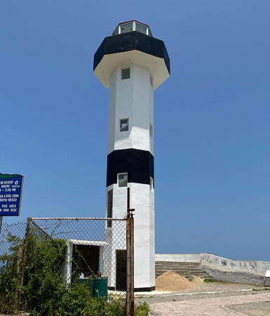
Date unknown. Active; focal plane 60 m (197 ft); three white flashes every 18 s. 15 m (49 ft) octagonal cylindrical tower with gallery and lantern. Lighthouse painted white with black gallery and one black band in the middle of the tower. A 2022 photo by Carlos Hernándz is at right, Trabas has Arndt's closeup photo, Lightphotos.net has a photo by Robert English, Sandra Zepeda has a 2019 closeup, Leigh Honeybourne contributed a 2009 photo, Diosa Coronada has a 2009 closeup, and Google has a street view and a satellite view. This is Oaxaca's best known lighthouse and the most often visited lighthouse of southern Mexico. Huatulco is about halfway between Puerto Ángel and Salina Cruz on the Gulf of Tehuantepec. The lighthouse stands above a famous blowhole where the sea shoots upward through a narrow opening. Located on a rocky point at the southwestern entrance to the Bahía de Huatulco. Accessible by a paved road; parking provided but may be crowded. Site open, tower closed. . ARLHS MEX-106; CF-20-045.1; Admiralty G3442; NGA 15260.
Boca Vieja
Date unknown. Active; focal plane 23 m (75 ft); two white flashes every 10 s. 8 m (26 ft) square unpainted rubblestone tower. Jaime Sánchez has a photo, Israel Caballero has a 2023 photo, Oliver Martinez has a street view from the base of the tower and Google has a satellite view. Located on a flat-topped rock about 25 km (15 mi) east of Puerto Ángel. Accessible only by boat. Site open, tower closed. CF-20-054; not listed by the Admiralty.

Huatulco Light, Santa María Huatulco, July 2022
Instagram photo by Carlos Hernándz
Puerto Ángel (Punta Azuca)
1900. Active; focal plane 56 m (184 ft); white flash every 5 s. 14 m (46 ft) octagonal masonry tower with lantern and gallery, attached to a 1-story keeper's house. Lighthouse painted white, lantern and gallery red. A 2021 photo by Belén Ceballos is at the top of this page, Tio Tiohernan also has a 2021 photo, Trabas has Capt. Peter's photo, Thomas Aleto has a panoramic view, a view from the sea is available, and Google has a satellite view. This historic light station appears to be well preserved. It is probably staffed. The fishing village of Puerto Ángel is at the southernmost point of Oaxaca, at the western end of the Gulf of Tehuantepec. Located atop a promontory southwest of the village. Site status unknown. ARLHS MEX-119; CF-20-030; Admiralty G3444; NGA 15256.
Punta Zicatela
Date unknown. Active; focal plane 11 m (36 ft); two white flashes every 10 s. 8 m (26 ft) square pyramidal concrete tower painted with red and white vertical stripes. Ramon Perez has a 2018 photo and Google has a distant satellite view. Located on a headland at the southeastern edge of Puerto Escondido. Site status unknown. CF-20-025; Admiralty G3445.5; NGA 15253.
Puerto Escondido
1936. Active; focal plane 40 m (131 ft); two white flashes every 10 s. 15 m (49 ft) octagonal cylindrical white concrete tower with gallery and lantern; lantern roof is red. David Cabrera has a 2009 photo (part of a much larger view), Trabas has Hendrik Martin Porath's photo and Google has a satellite view. Puerto Escondido is a very popular beach resort. Located at the edge of the cliffs at the western entrance to the harbor. Site status unknown; it's not clear if there is any public access to the lighthouse. ARLHS MEX-044; CF-20-020; Admiralty G3446; NGA 15252.
* [Cerro Hermoso] (2?)
Date unknown. Active; focal plane 11 m (36 ft); red flash every 6 s. 7.5 m (25 ft) square skeletal tower. Francisco Vallejo has a photo and Bing has a satellite view. In 2018 the breakwater was extended about 100 m (330 ft) and the light was relocated to the end. Gabriel Avila Luna has a closeup 2019 photo showing the relocated (or replaced) lighthouse. Located on the breakwater at Cerro Hermoso, a village about 55 km (35 mi) west of Puerto Escondido. CF-20-015; Admiralty G3447; NGA 15248.
Punta Galera (Chacahua)
Date unknown. Active; focal plane 32 m (105 ft); three white flashes every 12 s. 12 m (39 ft) square concrete tower with gallery, painted with red and white horizontal bands, attached to a 1-story keeper's cottage. A 2019 closeup is at right, Trabas has Eckhard Meyer's photo, a 2008 photo is available, there's a distant street view from the beach, and Google has a satellite view. A 2016 street view shows visitors climbing the lighthouse, but the tower was then in poor condition; the 2018 photo shows that it has been restored. Located on a headland on the west side of the entrance to the Lagunas de Chacahua. Accessible by a hiking trail. Site open, tower may be open. Site manager: Lagunas de Chacahua National Park. CF-20-010; Admiralty G3448; NGA 15244.

Puerto Galera Light, Lagunas de Chacahua, January 2019
Google Maps photo by JEDR
 

Guerrero Lighthouses

Eastern Guerrero (Acapulco Area) Lighthouses
* Punta Maldonado
Date unknown. Active; focal plane 40 m (130 ft); two white flashes every 10 s. 15 m (49 ft) square cylindrical concrete tower with lantern and gallery. The lantern was removed somtime around 2010 but a new lantern has been installed recently. Entire lighthouse is white. 1-story keeper's house. A 2023 closeup is available and Google has a street view and a satellite view. A 2006 closeup and a view from the sea show the lighthouse with its original lantern. Punta Maldonado is the southernmost town of Guerrero, and the lighthouse stands on or close to the boundary between Guerrero and Oaxaca. Accessible by road. Site open, tower closed. ARLHS MEX-060; CF-12-115; Admiralty G3452; NGA 15240.
* Punta Acamama
Date unknown. Active; focal plane 15 m (49 ft); three white flashes every 12 s. 10 m (33 ft) round cylindrical concrete tower with gallery. Lantnern removed. Tower is white, lantern red. Luis Castañon has a street view, Sadok Gómez has a street view from atop the tower, and Google has a satellite view. A contract to restore the lighthouse was awarded in 2006. Located on a headland at Playa Ventura, in eastern Guerrero, about 20 km (13 mi) southeast of Copala. Accessible by road. Site open, tower status unknown. ARLHS MEX-185; CF-12-110; Admiralty G3452.5; NGA 15236.
* Isla de la Roqueta (Acapulco) (3?)
Date unknown (station established 1858). Active; focal plane 115 m (377 ft); white flash every 10 s. 15 m (49 ft) round cylindrical concrete tower with four large ribs. Entire lighthouse painted white. A 2021 photo by Fernando Barajas is at right, Tommie Head has a closeup, Chucho Covarrubias has a 2019 photo, Tóbal Sánchez has a 2022 photo, Trabas has Capt. Peter's photo, Lightphotos.net has Robert English's distant view, Michelle Hernandez Lara has a distant 2022 drone view, and Google has a satellite view. Huelse has posted a postcard image of a square pyramidal tower and Eduardo Vazquez has an image of an octagonal masonry tower. This is a historic and still-staffed naval light station but we need information on its history. Despite the popularity of the Acapulco resort area this lighthouse is not very well known. Located at the highest point of the island, at the southwestern entrance to the Bahía de Acapulco. Accessible by passenger ferry from Playa Caletilla and a hiking trail. Site and tower generally closed, although Navy personnel may allow visitors to photograph the lighthouse. ARLHS MEX-069; CF-12-050; Admiralty G3456; NGA 15208.
Punta Norte de la Roqueta (2?)
Date unknown. Active; focal plane 23 m (75 ft); white flash every 2 s. 10 m (33 ft) round cylindrical concrete tower with gallery, painted white with two narrow black horizontal bands. The Cuaderno has a small photo and Google has an indistinct satellite view. Located on the north point of the Isla de la Roqueta marking the entrance to the channel to the port of Acapulco. Site status unknown. ARLHS MEX-143; CF-12-055; Admiralty G3460; NGA 15204.

Isla de la Roqueta Light, Acapulco, July 2021
Instagram photo by Fernando Barajas

Western Guerrero (Zihuatenejo Area) Lighthouse
Morro de Papanoa
Date unknown. Active; focal plane 130 m (427 ft); two white flashes every 10 s. 12 m (39 ft) square skeletal tower. Trabas has Capt. Peter Mosselberger's photo and Google has a satellite view. Located on a prominent, heavily forested cape about 70 km (45 mi) east southeast of Zihuatenejo. Site status unknown. CF-12-035; Admiralty G3465; NGA 15196.
[Punta Gorda (Barra de Potosí]
Date unknown. Active; focal plane 120 m (394 ft); four white flashes every 16 s. 7 m (23 ft) square skeletal tower. Trabas has Caot. Peter's photo, another closeup photo is available and Google has a satellite view. Located on a prominent cape about 20 km (13 mi) southeast of Zihuatenejo. Despite its small size this is an importnat light. Site status unknown. CF-12-025; Admiralty G3465.8; NGA 15185.
Punta Garrobo (Zihuatenejo)
1939. Active; focal plane 115 m (377 ft); three white flashes every 12 s. 13 m (42 ft) square cylindrical white tower without lantern attached to a 2-story keeper's house. Trabas has Capt. Peter's photo (also seen at right), Neftali Estrada has a 2021 photo, Michael Meo has a 2023 photo, and Google has a good satellite view. Located on the point, a very sharp promontory at the east side of the entrance to the Bahía de Zihuatenejo. Accessible by walking trails from the Playa las Gatas, a beach on the east side of the town; boats run frequently to Playa las Gatas from the pier downtown. Site open, tower status uncertain. ARLHS MEX-054; CF-12-020; Admiralty G3466; NGA 15180.

Information available on lost lighthouses:

Notable faux lighthouses:

  • Acapulco has a prominent waterfront lighthouse, but it is not recognized as an aid to navigation. The lighthouse appears in Arndt's photo on Trabas's site, Pablo Aguilar has a drone view, and Google has a satellite view.

Punta Garrobo Light, Zihuatenejo, March 2020
photo copyright Capt. Peter Mosselberger; used by permission

Adjoining pages: South: Guatemala Pacific | North: West Coast

Return to the Lighthouse Directory index | Ratings key

Posted 2003. Checked and revised January 8, 2025. Lighthouses: 34. Site copyright 2025 Russ Rowlett and the University of North Carolina at Chapel Hill