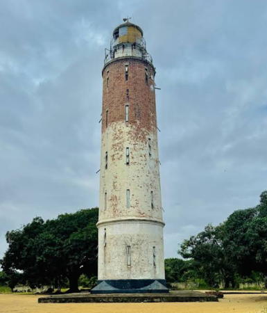
Lighthouses of Nigeria

The Federal Republic of Nigeria is a western African nation facing south into the northeastern corner of the Gulf of Guinea. Britain established its first colony at Lagos in 1861 and extended its control through a series of wars and struggles, finally declaring Nigeria a single colony with a federal structure in 1914. Nigeria has been independent since 1960. The country has become a leading producer of oil and gas but there has been unrest in the coastal regions where the wells are located.

The great delta of the Niger River occupies most of the central and eastern coast of the country, and three of the lighthouses mark entrances to the river system. The Bonny River Light, shown at right, is one of these three.

Nigeria is a federation of 36 states.

Aids to navigation in Nigeria are managed by the Nigerian Ports Authority. The ports are privatized, operated by a individual Terminal Operator organizations.

ARLHS numbers are from the ARLHS World List of Lights. Admiralty numbers are from volume D of the Admiralty List of Lights & Fog Signals. U.S. NGA List numbers are from Publication 113.

General Sources
Online List of Lights - Nigeria - South Coast
Photos by various photographers posted by Alexander Trabas. The Nigerian photos are by Capt. Peter Mosselberger ("Capt. Peter").
World of Lighthouses - Nigeria
Photos available from Lightphotos.net.
Lighthouses in Nigeria
Photos available from Wikimedia.
Afrikanische Leuchttürme auf historischen Postkarten
Postcards from the collection of Klaus Huelse.
Nigeria Map
A useful map of the country from Ezilion Maps.
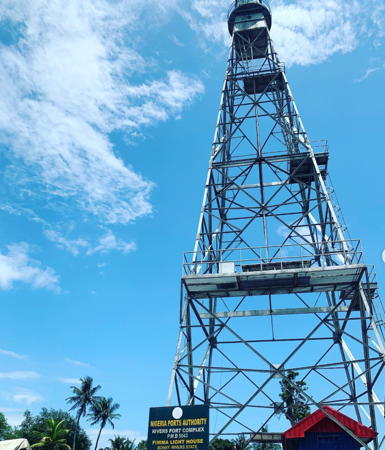

Bonny River Light, Niger Delta, November 2021
Instagram photo by Tola Daniels
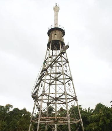
Rivers State Lighthouse
Finima (Bonny River, Field Point)
Date unknown (probably 1950s). Active; focal plane 30 m (98 ft); two white flashes every 20 s. 28 m (92 ft) square pyramidal skeletal tower with lantern and gallery. Entire lighthouse is steel gray. Tola Daniels has the 2021 closeup seen above, Trabas has Captain Peter's 2005 photo, Neil Maneewong Gardner has a 2018 closeup, a 2013 photo is available, and Google has a satellite view. The lighthouse marks the entrance to Port Harcourt, the capital of Rivers State and a major base for the oil industry. Located on the east side of the entrance to the Bonny River, at the eastern edge of the Niger River Delta. Site open, tower closed. ARLHS NIG-002; Admiralty D3940; NGA 25064.

Bayelsa State Lighthouse
Akassa (Palm Point)
1910 (relocated in 1917). Active; focal plane about 65 m (213 ft); one long (1.2 s) white flash every 10 s. 60 m (197 ft) hexagonal skeletal tower with gallery; the lantern was removed and replaced by a white barbell-shaped fiberglass tower increasing the height of the lighthouse. A 2024 photo is at right, another photo and a distant view are available, and Google has a distant satellite view. Ebi Dressman has a series of photos from a 2022 visit climbing the tower, The lighthouse was initially built at a different location and was relocated between 1915 and 1917 (not in 1912, as many sources state) to Palm Point. It's not known when the upper section was added, but it was needed to raise the light above surrounding trees. The light marks the southernmost point of the Niger River Delta. Located on the east side of the entrance to the Nun River, one of the many branches of the Niger. Site status unknown. ARLHS NIG-004; Admiralty D3930; NGA 25056.

Delta State Lighthouse
#Ogidigben (Oidigbe, Escravos River)
Date unknown (probably 1950s). Inactive and probably removed; listed by NGA with focal plane 40 m (131 ft); three white flashes every 20 s. This was an approx. 40 m (131 ft) square pyramidal skeletal tower with lantern, painted white with a black horizontal band. No photo available and no large tower is seen in Google's satellite view of the area. The Escravos River is the site of large and controversial natural gas terminals; residents protesting this industrialization have seized the facilities and held hostages several times. Escravos is the Portuguese word for slaves, a reference to a a former slave trading base on the river. Located on the east side of the river entrance near Ogidigben, on the west side of the Niger River Delta. Site status unknown. ARLHS NIG-003; ex-Admiralty D3900; NGA 25036.


Palm Point Light, Akassa, August 2024
Facebook photo by jaw Heritage Television International

Escravos River Main Mole
Date unknown. Active; focal plane probably about 15 m (49 ft); red light, pattern unknown. Probably a skeletal tower. This light has replaced the historic lighthouse (previous entry). Located at the end of a lon, curving breakwater extending from the east side of the river entrance. The light is not seen in Google's satellite view. Site and tower closed. Admiralty D3904; NGA 25044.
Escravos River Island Mole
Date unknown. Active; focal plane about 25 m (82 ft); white light, pattern unknown. Approx. 25 m (82 ft) square skeletal tower. No photo available but Google has a satellite view. Located just offshore of the north bank of the Escravos River, site of a large Chevron oil and gas terminal. Site status unknown. Admiralty D3910.

Lagos State Lighthouses
Lagos, the largest city of Nigeria and the colonial capital, is a large city and major port in the southwestern corner of the country.

Lekki East Breakwater (LB1)
2022. Active; focal plane 12 m (39 ft); green light, 2 s on, 2 s off. 8 m (26 ft) skeletal tower on a square concrete platform. No photo available but Google has a satellite view. Lekki Port is a new deep-sea port about 80 km (50 mi) east of Lagos. With a dredged harbor depth of 16.5 m (54 ft) the port is designed to serve the largest modern cargo vessels. Located on the east breakwater of the harbor. Site and tower closed. Admiralty D3889.3.
Lekki West Breakwater (LB2)
2022. Active; focal plane 16 m (52 ft); red light, 2 s on, 2 s off. 12 m (39 ft) skeletal tower on a square concrete platform. No closeup photo available but Google has a satellite view. The light is barely visible to the left of the ship in a distant view by Ayodele Monday. Located on the west breakwater of the harbor. Site and tower closed. Admiralty D3889.1.
Lagos East Mole (2)
Date unknown. Active; focal plane 9 m (30 ft); green flash every 3 s. 9 m (30 ft) round hourglass-shaped tower painted with green and white horizontal bands. Daniele Savio has a 2019 photo and Google has a distant 2021 street view and an indistinct satellite view. Trabas has Capt. Peter's 2005 photo of the earlier post light. Located on the east breakwater at the entrance to Lagos. Site status unknown. Admiralty D3873; NGA 24976.
Lagos East Mole Middle (2?)
Date unknown. Possibly active (the original light was inactive at least since 2014); listed by NGA with a flashing red light. Joe Mazibuko has a 2022 photo of a tall mast, painted with red and white horizontal bands, that appears to carry a light. The light was formerly mounted on the roof of a ramshackle 3-story concrete signal station. Trabas has posted a closeup photo by Captain Peter. Google's satellite view shows that the area has been filled and redeveloped; the shadow of the new mast is shown. Located on the east mole of Lagos harbor. Site status unknown. ARLHS NIG-005; ex-Admiralty D3878; NGA 24992.
* Necom House
Date unknown (building completed 1979). Active; focal plane 160 m (525 ft); white flash every 30 s. Light mounted atop the communications tower on the roof of the 32-story Necom House. Trabas has Capt. Peter's photo, Lateef 'deji Oyedokun has a 2008 photo, and Google has a street view and a satellite view. Necom House is the headquarters of the former Nigerian External Communications (Necom), now privatized as part of Nitel, Ltd. The powerful light has a range of 65 km (40 mi) and serves as the landfall light for Lagos. It was dropped from the NGA List in 2010 but is still listed by the Admiralty. Located on the waterfront in downtown Lagos. Site and building open, tower closed. Admiralty D3871; ex-NGA 25028.
Lagos West Mole (2)
Date unknown. Active; focal plane 9 m (30 ft); red flash every 3 s (?). 9 m (30 ft) round hourglass-shaped tower painted with red and white horizontal bands. A distant 2025 photo is available, Philip Glenton has a 2013 photo and a 2012 photo, and Google has a very distant 2017 street view but the tower is not seen in Google's satellite view. Located on the west breakwater at the entrance to Lagos. Site status unknown. Admiralty D3872.
* Tarkwa Bay (Beecroft Point, Lagos) (2)
1891 (station established 1877). Reported inactive since 2009 but listed with focal plane 26 m (85 ft); two white flashes, separated by 3.2 s, every 15 s. 27 m (89 ft) stone tower with lantern and gallery. Tower painted white with two black horizontal bands. Hussaini Muhammad Auwal's 2024 photo is at right, Miguel Gomez has a 2024 photo, a 2023 photo and a 2021 photo are available, Trabas has Capt. Peter's 2005 distant view, a 2008 photo is available, Huelse has a historic postcard view, and Google has a satellite view. Lightphotos.net has a photo showing a very different daymark, white with two black horizontal bands; this photo is dated 2014 but may have been taken much earlier than that since the present daymark seems to be of long standing. We need much better information on this historic lighthouse. An August 2018 Facebook post by Dayo Adedayo Photography shows the lighthouse in very poor condition; according to accompanying text it was deactivated in 2009 "with the building of a modern electronic navigation system next to the current site." Located about 1.5 km (1 mi) northwest of the point of land at the western entrance to Lagos Harbour. Site open, tower closed. ARLHS NIG-001; Admiralty D3870; NGA 24968.

Tarkwa Bay (Beecroft Point) Light, Lagos, July 2024
Google Maps photo by Hussaini Muhammad Auwal

Information available on lost lighthouses:

Notable faux lighthouses:

Adjoining pages: East: Cameroon | West: Benin

Return to the Lighthouse Directory index | Ratings key

Posted September 23, 2005. Checked and revised May 3, 2025. Lighthouses: 12. Site copyright 2025 Russ Rowlett and the University of North Carolina at Chapel Hill.