Lighthouses of Norway: Northern Salten and Ofoten (Narvik Area)

The Kingdom of Norway (Norge in Norwegian) is one of the world's most maritime nations. The country is long and narrow, with drowned valleys called fjords that bring the sea far inland in most regions. The mainland coast is estimated to be 2650 km (1650 mi) long and when all the islands and minor indentations are counted the total coastline approaches an astonishing 60,000 km (37,500 mi), long enough the go around the world one and a half times. With such a lengthy and rocky shore it's not surprising that Norway has a large number of lighthouses.

Norway is divided into counties (fylker) and the counties are divided into townships (kommuner). This page lists lighthouses in the northern mainland portion of Norway's Nordland County, including the Steigen and Hamarøy townships in the northern part of the traditional Salten district and the Narvik, Evenes, and Lødingen townships in the traditional Ofoten district. Narvik is the largest port and community in this area. This region lies north of the Arctic Circle, with a coastline that is quite rugged and deeply indented by many fjords.

In Norwegian a lighthouse is a fyrtårn (fire tower) or simply a fyr; a fyrlykt is a beacon and a lyktehus is a lantern. Øy is an island, holmen is an islet, skjær is a skerry (a tiny island or rocky reef), sund is a strait (often between an island and the mainland), bukt is a bay, nes is a headland, and havn is a harbor.

Aids to navigation in Norway are maintained by the Kystverket (Coast Directorate), an agency of the Ministry of Transport and Communications.

ARLHS numbers are from the ARLHS World List of Lights. NF numbers are from the Norsk Fyrliste. Admiralty numbers are from volume L of the Admiralty List of Lights & Fog Signals. U.S. NGA List numbers are from Publication 115.

General Sources
Norsk Fyrhistorisk Forening
News and photos from the Norwegian Lighthouse Association.
Online List of Lights - Norway - Nordland North Part
Photos by various photographers posted by Alexander Trabas. Most of the photos for this area are by Capt. Peter Mosselberger ("Capt. Peter").
Lighthouse Pages from Anke and Jens - Norway
Excellent photos of more than 60 Norwegian lighthouses.
Norway's Fjorden and Lighthouses
Photos taken by Charles W. Bash on a 2010 cruise from Bergen to North Cape.
Leuchttürme an der norwegischen Küste
Photos posted by Bernd Claußen.
Lighthouses in Nordland
Photos available from Wikimedia.
Norwegische Leuchttürme auf historischen Postkarten
Historic postcard images posted by Klaus Huelse.
Liste over Norske Fyr
From Wikipedia, a handy list of Norwegian light stations with their dates of establishment.
Norsk Fyrliste
The official Norwegian light list can be downloaded in six .pdf volumes.
GPSNavigationCharts
Navigation chart information for this area.
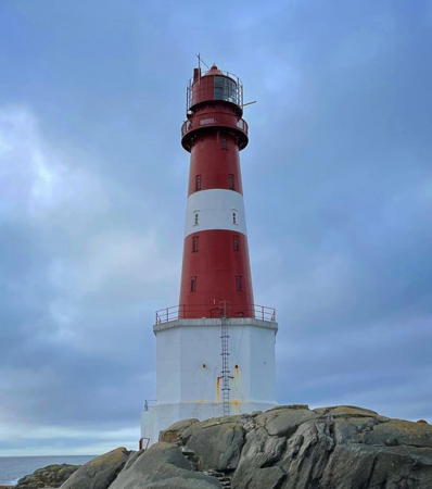

Måløy-Skarholmen Light, Steigen,October 2021
ex-Instagram photo by Alex Robins
Steigen Lighthouses
Ola-Persøy
Date unknown. Active; focal plane 5.5 m (18 ft); white, red or green light depending on direction, 2 s on, 2 s off. 6.5 m (21 ft) concrete post with lantern and gallery. Lighthouse is white, lantern roof painted red. No photo available but Google has a satellite view. Ola-Persøy is a small island off the tip of Leines, a promontory of the mainland. Located on the northeastern tip of the island. Accessible only by boat. Site open, tower closed. NF-709000; Admiralty L2612; NGA 10888.
Steinsholmen Øvre
Date unknown. Active; focal plane 17 m (56 ft); white, red or green light depending on direction, 3 s on, 3 s off. 6.5 m (21 ft) square tower with lantern and gallery. Lighthouse painted white, lantern roof red. No photo available but Google has a satellite view. This the rear light of a range guiding vessels leaving the Leinesfjord. Located on an island off the south side of the entrance to the fjord. Accessible only by boat. Site open, tower closed. NF-709400; Admiralty L2614.1; NGA 10896.
Leines
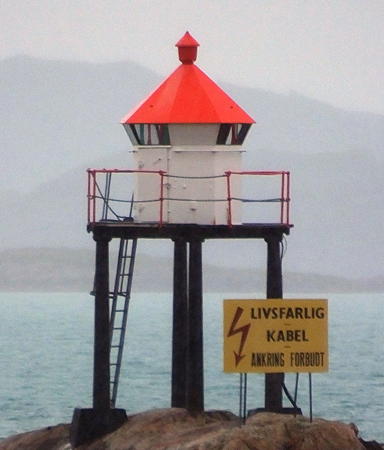
Date unknown. Active; focal plane 5 m (17 ft); white, red or green light depending on direction, occulting twice every 8 s. 6 m (20 ft) lantern mounted on a platform supported by piles. Trabas has a closeup photo by Capt. Peter (also seen at right) and Google has a satellite view. Located on a reef just off the south side of the entrance to the Leinesfjord. Accessible only by boat. Site open, tower closed. NF-709800; Admiralty L2616; NGA 10904.
Andholmen
Date unknown. Active; focal plane 17.5 m (57 ft); white, red or green light depending on direction, 3 s on, 3 s off. 6 m (20 ft) square tower with lantern and gallery. Lighthouse painted white, lantern roof red. No photo available but Bing has a satellite view. Located on an island about 8 km (5 mi) west of the entrance to the Leinesfjord. Accessible only by boat. Site open, tower closed. NF-710200; Admiralty L2622; NGA 10912.

Leines Light, Steigen
photo copyright Capt. Peter Mosselberger; used by permission
Måløy-Skarholmen
1922. Active; focal plane 42 m (138 ft); white, red or green light depending on direction, occulting twice every 8 s. 34 m (112 ft) round cast iron tower with lantern and gallery, centered on a 2-story concrete block keeper's house. The original 2nd order Fresnel lens is in use. Tower painted red with one white horizontal band; keeper's house painted white. A 2021 photo by Alex Robins is at the top of this page, the Lighthouse Association has a page for the lighthouse, Trabas has Arno Siering's photo, Steinar Fagerli has a distant view from the sea, and Google has a satellite view of the station. The house has dwelling units for three keepers and was in use until the lighthouse was automated in 1979. The lighthouse marks the entrance to the upper Vestfjord, the broad sound between the mainland and the Lofoten Islands. Located on a small skerry about 20 km (13 mi) north of Bodø. Site and tower closed; landing on the island is notoriously difficult. . ARLHS NOR-169; NF-711000; Admiralty L2626; NGA 10920.
Sildeskjær (Sildskjaer)
Date unknown. Active; focal plane 5 m (17 ft); white, red or green light depending on direction, 3 s on, 3 s off. 6 m (20 ft) lantern mounted on a platform supported by piles. No photo available but Bing has a satellite view. Located on a skerry south of Grytøy. Accessible only by boat. Site open, tower closed. NF-711500; Admiralty L2630; NGA 10924.
#Skaten
Date unknown. Removed in 2017. This was a 11 m (36 ft) lantern and gallery mounted on a stone cairn. No photo available but Bing has a satellite view. Although the lantern was removed the cairn probably remains. Formerly located on a skerry in the harbor at the north end of Grytøy. Accessible only by boat. Site open, tower closed. ex-NF-712400; ex-Admiralty L2642; NGA 10944.
#Kjuklingflu (1)
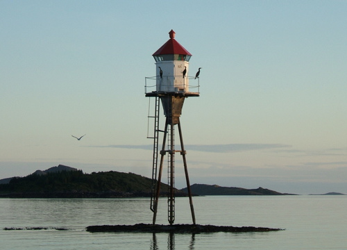
Date unknown. Inactive since 2018 and probably removed. 10 m (33 ft) lantern and gallery mounted on a tripod. Lantern painted white with a red roof. Jan Leversund's 2006 photo is at right and Bing has a satellite view. "Kjuklingflu" means "chicken reef," but the reference here is to the cormorants seen in the photo. Located on a reef at the east side of the harbor entrance at Nordskot. Site open, tower closed. ex- NF-712900; ex-Admiralty L2650; NGA 10968.
Store Jensøy
Date unknown. Active; focal plane 17 m (56 ft); two flashes every 10 s, white, red or green depending on direction. 5.5 m (17 ft) lantern and gallery mounted on a stone cairn. No photo available but Google has a distant satellite view. Located on an island at the southwest end of Engelvær archipelago, a group of more than 100 rocky islets now set aside as a nature reserve. Accessible only by boat. Site open, tower closed. NF-714000; Admiralty L2652; NGA 10984.

Kjuklingflu Light, Steigen, July 2006
Flickr photo copyright Jan Leversund; used by permission
Flatøy (2)
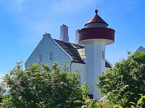
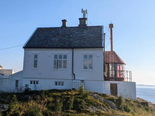
1966 (station established 1882). Inactive since 2006. Approx. 16 m (52 ft) octagonal cylindrical concrete tower with lantern and gallery, attached to one side of a 1-1/2 story keeper's house. Lighthouse painted white; lantern roof and gallery painted red. The station includes a generator house, farm buildings, and the ruins of a boathouse. A 2023 photo is at right, Wikimedia has Finn Rindahl's distant views and a closeup by Danckert Monrad-Krohn for the Culture Ministry, and Google has a satellite view. The house is the 1882 original but the light tower was apparently built in 1966 when the light was automated. In 1985 the station was leased to the Stiegen Sports Diving Club, which restored the building and used it as a clubhouse until 2005. The station was then leased to Steigen Kommune and a friends group was established to restore and manage the property. This restoration was completed in 2010. The station now has 18 beds for overnight accommodations. Note: Flatøy (Flat Island) is a common name and there are other Flatøy lighthouses in the Bergen and Hammerfest areas. Located at the west end of Flatøy, a small island on the southeast side of the Vestfjord about 8 km (5 mi) west of Steigen. Accessible only by boat. Site open, tower closed. Owner: Direktoratet for Naturforvaltning. Site manager: Steigen Kommune (Flatøy Fyr). . ARLHS NOR-084.
Flatøy (3)
2006 (station established 1882). Active; focal plane 44 m (144 ft); flash every 5 s, white or red depending on direction. 7 m (23 ft) concrete post with lantern and gallery. Lighthouse painted white, lantern roof red. The light is seen in one of Finn Rindahl's photos and Google has a satellite view. Located about 100 m (110 yd) north of the historic lighthouse. NF-714500; Admiralty L2658; NGA 10992.
Kattskjær
Date unknown. Active; focal plane 7.5 m (25 ft); white, red or green light depending on direction, 3 s on, 3 s off. 7 m (23 ft) concrete post with lantern and gallery. Lighthouse painted white, lantern roof red. Trabas has Capt. Peter's photo and Google has a distant satellite view. Located on a skerry in the Flatsund, which separates Engeløya from the mainland. Accessible only by boat. Site open, tower closed. NF-714800; Admiralty L2664; NGA 11008.


1882 Flatøy Light, Steigen, July 2023
Instagram photo by Flatøya fyr

Bolsøygalten
Date unknown. Active; focal plane 5 m (17 ft); flash every 5 s, white, red or green depending on direction. 6 m (20 ft) lantern and gallery mounted on a stone cairn. Trabas has Capt. Peter's distant photo and Google has a satellite view. Located on a skerry in the entrance to the Sagfjord, east of Engeløya. Accessible only by boat. Site open, tower closed. NF-715700; Admiralty L2668; NGA 11016.
Klingenberg
Date unknown. Active; focal plane 5 m (17 ft); white, red or green light depending on direction, 3 s on, 3 s off. 6.5 m (21 ft) lantern mounted on a platform supported by piles. Trabas has Capt. Peter's photo and Google has a satellite view. Located on a skerry south of Finnøy, on the north side of the Sagfjord. Accessible only by boat. Site open, tower closed. NF-715900; Admiralty L2672; NGA 11020.
Skagstadsund
Date unknown. Active; focal plane 6 m (20 ft); white, red or green light depending on direction, occulting once every 6 s. 7 m (23 ft) square tower with lantern and gallery. Lighthouse painted white, lantern roof red. Trabas has Capt. Peter's photo (also seen at right) and Google has a satellite view. Located on the northeast coast of Engeløy facing the Skagstadsund, which separates Engeløy from Lundøy. Accessible only by boat. Site open, tower closed. NF-717300; Admiralty L2684; NGA 11036.

Hamarøy Lighthouses
Buvåg (Kufiskholmen) (1)
Date unknown (station established 1917). Replaced in 2024 and probably to be removed. 6 m (20 ft) square skeletal tower with lantern and gallery. Lantern painted white with a red roof. Trabas has Capt. Peter's photo, Rune Danielsen has a street view, and Google has a satellite view. The light (focal plane 5 m (17 ft); green light, 1 s on, 1 s off) has been moved to a post. Located on a small island on the south side of the entrance to Buvåg, about 8 km (5 mi) northwest of Hamsund. Site status unknown. ex-NF-718500. Active light: NF-718501; Admiralty L2690; NGA 11048.
Hamsundpollen
Date unknown. Active; focal plane 6.5 m (21 ft); white, red or green light depending on direction, 2 s on, 2 s off. 6 m (20 ft) square tower with lantern and gallery. Lighthouse painted white, lantern roof red. No photo available but Google has a distant satellite view. Located on a promontory guiding vessels into the Hamsund, a protected sound east of Buvåg. Site status unknown. NF-718700; Admiralty L2691; NGA 11088.
* Brennvika
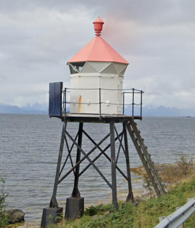
Date unknown. Active; focal plane 9 m (30 ft); white, red or green light depending on direction, occulting twice every 8 s. 6 m (20 ft) lantern on a platform supported by piles. Lantern painted white with a red roof. Trabas has Capt. Peter's photo, Google has the 2022 street view seen at right, and Bing has a satellite view. Located beside the coast highway 665 about 6.5 km (4 mi) south of the Tranøy lighthouse. Site open, tower closed. NF-719300; Admiralty L2695; NGA 11060.

Brennvika Light, Hamarøy, August 2022
Google Maps street view
**** Tranøy (2)
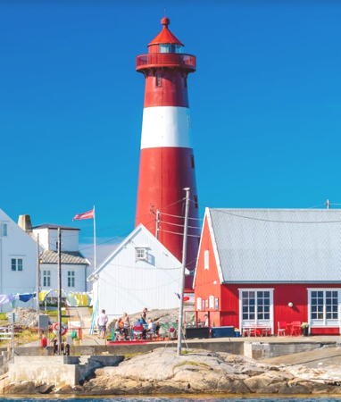
1914 (relocated here in 1936; this station established 1864). Active; focal plane 28 m (92 ft); white, red or green light depending on direction, occulting three times every 10 s. 27 m (89 ft) round cast iron tower with lantern and gallery. Tower painted red with one white horizontal band. A complete and well-preserved light station, including a 1-1/2 story duplex keeper's house, generator house, boathouse, and farm buildings. Apparently the original lighthouse became an assistant keeper's house and has been preserved (without its lantern). The boathouse has been renovated as a seafood restaurant. A 2021 photo is at right, the Lighthouse Association has a page for the lighthouse, Trabas has Capt. Peter's photo, Eva Eiler has a good photo, Kristian Hedberg has another photo, Wikimedia has Martin Dyb's photo, and Google has a satellite view of the station. The original light was on the roof of the keeper's house. The present lighthouse was built in 1914 at Moholmen in the Inner Lofoten Islands; it was replaced there by a shorter tower and relocated here in 1936. Beginning in 1993 the light station has been developed as a tourist attraction; tours and overnight accommodations are available. The site is remarkably scenic, even by the standards of an exceptionally scenic nation, with a spectacular view across the Vestfjord to the high mountains of the Lofoten Islands. Located on a small island on the south side of the upper Vestfjord about 12 km (7.5 mi) north of Hamarøy. Accessible by road; a footbridge leads to the light station. Site open; the tower is open for climbing during the summer season. Site manager: Tranøy Fyr . ARLHS NOR-047; NF-719500; Admiralty L2696; NGA 11064.
Steinsos
Date unknown (station established 1896). Active; focal plane 9 m (30 ft); white, red or green light depending on direction, occulting once every 6 s. 8 m (26 ft) tower, with an octagonal lantern and gallery supported by piles atop a round stone base. Lighthouse painted black, lantern white with a red roof. Trabas has Capt. Peter's photo, there is a distant view showing the Lofoten mountains in the background, and Bing has a satellite view. Located on a skerry about 3 km (2 mi) east of the Tranøy lighthouse. Accessible only by boat. Site open, tower closed. NF-719900; Admiralty L2702; NGA 11076.
Hamlotskjær (Hamlotoskjær) (1)
Date unknown. Replaced in 2024 and possibly removed. 8 m (26 ft) lantern supported by tripod piles. Lantern painted white with a red roof. Trabas has Capt. Peter's photo and Google has a fuzzy satellite view. The light (focal plane 4.5 m (15 ft); green light, 1 s on, 1 s off) has moved to a post. Located on a reef in the Tannøysund off the east end of Hamlotsholmen. Accessible only by boat. Site open, tower closed. ex-NF-720600; ex-Admiralty L2704. Active light: NF-720605; Admiralty L2703.5; NGA 11092.

Tranøy Light, Hamarøy, August 2021
Google Maps photo by Connie
Ansnesholmen
Date unknown. Replaced in 2024 and possibly removed. 6 m (20 ft) lantern supported by tripod piles. Lantern painted white with a red roof. Trabas has Capt. Peter's photo and Google has a fuzzy satellite view. The light (focal plane 4.5 m (15 ft); red light, 1 s on, 1 s off) has moved to a post. Located on a reef in the Tannøysund off the south side of Ansnesholmen. Accessible only by boat. Site open, tower closed. ex-NF-721000; ex-Admiralty L2712. Active light: NF-721012; Admiralty L2713; NGA 11096.

Narvik Lighthouses
Korsnes
1914. Active; focal plane 8 m (26 ft); white, red or green light depending on direction, occulting once every 6 s. 4 m (13 ft) octagonal lantern mounted on a stone base. Lantern painted white with a red roof. Trabas has Capt. Peter's closeup photo and Google has a satellite view. Located at the tip of the Korsnes promontory, about 1 km (0.6 mi) north of Bognes. There should be a view of this light from ferries between Bognes and Lødingen, Lofoten. Site open, tower closed. NF-722000; Admiralty L2718; NGA 11104.
Barøy (1)
1903. Inactive since 2010. Lantern mounted on a concrete base and attached to the west end of a 1-story wood keeper's house. Terje Håkstad's 2024 photo is at right, Alexander Solvold-Perander has a 2021 photo, Trond Bertheussen also has a 2021 photo, and Google has a satellite view of the station. Barøy is an island at the upper (east) end of the Vestfjord. The Kystverket has restored the lighthouse and retains ownership; according to a June 2018 newsletter article it was open to proposals for new uses and managers. Apparently this led to a lease and now Gunnars Fiskelykke, a fishing guide company, offers tours to the lighthouse as well as overnight accommodations. Located at the west end of the island. Accessible only by boat; there should be at least a distant view from ferries sailing for Lødingen in the Lofotens. Site open, lighthouse open to tours. Site manager: Gunnars Fiskelykke (Barøy Fyr) . ARLHS NOR-004.
Barøy (2)
2010 (station established 1903). Active; focal plane 29 m (95 ft); white, red or green light depending on direction, occulting twice every 8 s. Approx. 7 m (23 ft) round cylindrical tower with lantern and gallery. Lighthouse is white, lantern roof red. Petra Metz has a 2023 closeup photo. and a 2021 photo is available. Located in front of the historic lighthouse. NF-725100; Admiralty L2730; NGA 11132.
Hamnesholmen
Date unknown. Active; focal plane 11.5 m (38 ft); white, red or green light depending on direction, occulting three times every 10 s. 7 m (23 ft) square skeletal tower, covered with siding, with lantern and gallery. Lighthouse painted white, lantern roof red. Trabas has Capt. Peter's photo and Google has a satellite view. Located on a small island off a headand, on the south side of the Ofotfjord. Accessible only by boat. Site open, tower closed. NF-727000; Admiralty L2746; NGA 11156.

Barøy Light, Ballangen, Augst 2024
Instagram photo by Terje Håkstad
Tjellebotn (Kjeldebotn)
Date unknown (station established 1896). Active; focal plane 4 m (13 ft); white or red light depending on direction, 3 s on, 3 s off. 5 m (17 ft) lantern and gallery on four short piles, standing on a stone base. Lantern painted white with a red roof, base and piles painted black. Trabas has Capt. Peter's photo, a distant view is available, and Bing has a satellite view. Located near Skårnes about 1.5 km (1 mi) northeast of Kjeldebotn, on the south side of the Ofotfjord. Site open, tower closed. NF-727200; Admiralty L2748; NGA 11168.
* Aspelund
Date unknown. Active; focal plane 6 m (20 ft); white, red or green light depending on direction, occulting twice every 8 s. 5 m (17 ft) lantern mounted on a square stone tower. Lantern painted white with a red roof. Trabas has Capt. Peter's closeup photo and Google has a street view and a satellite view. NGA misspells the name as Aspelsund. Located on the east side of the Grindfjord, a southern branch of the Ofotfjord about 40 km (25 mi) south of Narvik. Site open, and anyone can climb the steps to the lantern. NF-729300; Admiralty L2769; NGA 11216.
* Narvik (1)
Date unknown. Inactive. Approx. 6 m (20 ft) concrete post with gallery. Lantern removed. Entire lighthouse is white. Google has a street view and Bing has a satellite view. This light was built on a headland in Ankenesstrand, across the fjord from Narvik. When the Ankenes Marina was built on this headland the light was moved to a new tower (next entry). A skeletal tower carrying radar or communications gear now stands atop the tower. Site open, tower closed.
* Narvik (2)
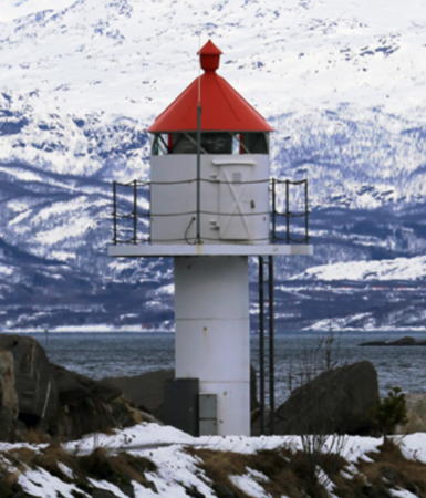
Date unknown. Active; focal plane 7.5 m (25 ft); white, red or green light depending on direction, occulting once every 6 s. 6 m (20 ft) concrete post with lantern and gallery. Lighthouse painted white, lantern roof red. Bergtor Roald Opsett's photo is at right, Trabas has Capt. Peter's photo, several photos (1/2-2/3 the way down the page) show auroral displays above the lighthouse, Ebba Jenssen also has a photo of an aurora over the lighthouse, and Google has a distant street view and a satellite view. This light appeared in an episode of the U.S. television reality show The Amazing Race in October 2010. Located on an elbow of the breakwater of the Ankenes Marina. Accessible by walking the pier. Site open, tower closed. NF-729700; Admiralty L2771; NGA 11224.

Evenes Lighthouses
* Sletbakken (Bogen) (2?)
Date unknown. Active; focal plane 7.5 m (25 ft); white, red or green light depending on direction, 1 s on, 1 s off. 6 m (20 ft) round fiberglass tower with lantern and gallery. Lighthouse colored white, lantern roof red. Trabas has Capt. Peter's photo, Valtteri Mulkahainen has a closeup street view, and Google has a satellite view. Located at the entrance to Bogen on the north side of the Ofotfjord. Site open, tower closed. NF-727700; Admiralty L2755; NGA 11180.
Liland
Date unknown. Active; focal plane 6.5 m (22 ft); white, red or green light depending on direction, 3 s on, 3 s off. 4 m (13 ft) lantern, white with a red roof. No photo available but Google has a satellite view. Located at the south point of Ungsmaløya, an island off the village of Liland southwest of Bogen. Accessible only by boat. Site open, tower closed. NF-727400; Admiralty L2752; NGA 11172.

Narvik Light, Narvik, March 2016
ex-Panoramio photo by Bergtor Roald Opsett

Lødingen Lighthouses
* Lødingen (Hjertholmen) (3)
1914 (station established 1862). Active; focal plane 22 m (72 ft); white, red or green light depending on direction, occulting once every 6 s. Approx. 8 m (26 ft) square pyramidal skeletal tower with lantern and gallery. Tower covered with metal siding. Lighthouse painted white; lantern roof is red. Annbritt Kvist's 2023 photo is at right, Trabas has Capt. Peter's photo, Wikimedia has a good view, Stefan Seger has a good photo, a closeup photo and a more distant view are available, Google has a street view and a satellite view. The stone foundations of the second (1892) lighthouse are next to the modern light; it was closed and demolished when the Rotvær lighthouse was activated. Located on Hjertholmen, a promontory sheltering the south and east sides of the harbor of Lødingen. There should be an excellent view from ferries arriving in Lødingen from the mainland. Site open, tower closed. ARLHS NOR-160; NF-734000; Admiralty L2783; NGA 11284.
Rotvær (2)
1985 (station established 1914). Active; focal plane 22 m (72 ft); white, red or green light depending on direction, occulting once every 6 s. 13 m (43 ft) round cylindrical fiberglass tower with lantern and gallery. Lighthouse painted with black and white horizontal bands (an unusual daymark for Norway); lantern roof painted red. Espen Viklem Eidum has a 2023 photo, the Lighthouse Association has a page for the lighthouse, Espen Eidum has a view from the sea and Google has a satellite view. The original lighthouse had a lantern on the roof of a keeper's house; it was demolished when the new one was built. It appears that the station's boathouse survives. Located at the east end of an island, part of dangerous reef, about 6 km (3.5 mi) south southwest of Lødingen. Accessible only by boat. ARLHS NOR-189; NF-734500; Admiralty L2785; NGA 11292.
Svensgam (Svendsgam)
Date unknown. Active; focal plane 5 m (17 ft); white, red or green light depending on direction, 3 s on, 3 s off. 4.5 m (15 ft) lantern on a rubblestone tower. Lantern painted white with a red roof. Trabas has Capt. Peter's photo and Google has an indistinct satellite view. Located on the east side of the entrance to the Kanstadfjord. Site status unknown. NF-734900; Admiralty L2787; NGA 11300.

Lødingen Light, Lødingen, July 2023
Google Maps photo by Annbritt Kvist
 
Rinøy
Date unknown. Active; focal plane 7 m (23 ft); white, red or green light depending on direction, occulting twice every 8 s. 6 m (20 ft) square pyramidal skeletal tower with lantern and gallery. Tower covered with metal siding. Lighthouse painted white; lantern roof is red. Trabas has Capt. Peter's photo and Google has a street view and an indistinct satellite view. Located at the northeastern tip of Rinøy, marking the entrance to Rinøyhamn, a small fishing village about 10 km (6 mi) west of Lødingen. Site open, tower closed. NF-735500; Admiralty L2788; NGA 11296.
Seingen (2)
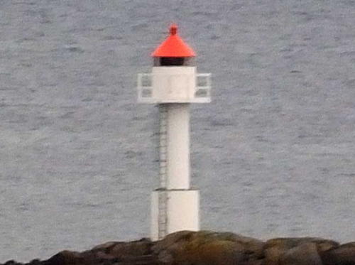
2023. Active; focal plane 9.5 m (31 ft); white, red or green light depending on direction, 2 s on, 2 s off. 8 m (26 ft) round fiberglass tower with lantern and gallery. Tower colored white; lantern roof red. Trabas has Capt. Peter's photo (seen at right) and Google has a satellite view. This light replaced a lantern mounted on a platform supported by piles. Located on a skerry on the north side of the upper Vestfjord. Accessible only by boat. Site open, tower closed. NF-737000; Admiralty L2796; NGA 11320.
Smitskjær
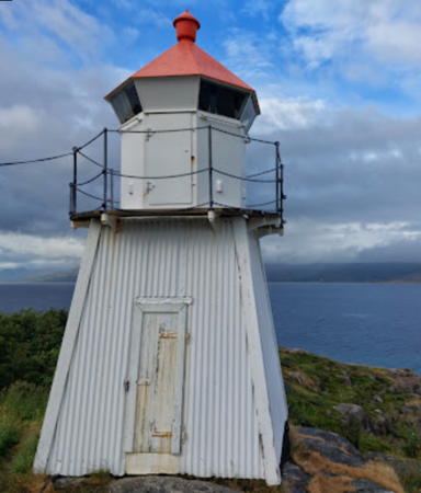
Date unknown. Active; focal plane 12 m (39 ft); white, red or green light depending on direction, 1 s on, 1 s off. 7 m (23 ft) lantern mounted on a round rubblestone tower. Lantern painted white with a red roof. Trabas has Capt. Peter's photo (also seen at right) and Google has a satellite view. Located on a skerry on the north side of the upper Vestfjord, about 1 km (0.6 mi) north of the Seingen light. Accessible only by boat. Site open, and visitors can climb to the lantern. NF-737300; Admiralty L2798; NGA 11324.
Lysøskjæret
Date unknown. Active; focal plane 10 m (33 ft); white, red or green light depending on direction, 2 s on, 2 s off. 8.5 m (28 ft) concrete post with lantern and gallery. Lighthouse painted white, lantern roof red. Denis Philippov has a distant drone view and Google has a satellite view. Located on a skerry east of Svellingen in the Risvær archipelago. Accessible only by boat. Site open, tower closed. NF-739200; Admiralty L2809; NGA 11364.

Seingen Light, Lødingen, 2023
photo copyright Capt. Peter Mosselberger; used by permission
Risvær (2)
Date unknown. Active; focal plane 8.5 m (28 ft); white, red or green light depending on direction, occulting twice every 8 s. 7 m (23 ft) round fiberglass tower with lantern and galley. Lighthouse colored white, lantern roof red. Trabas has Capt. Peter's photo and Google has a distant satellite view. This light replaced a square skeletal tower, covered with siding, with lantern and gallery. Located on a skerry at the southeastern edge of the Risvær archipelago. Accessible only by boat. Site open, tower closed. NF-739400; Admiralty L2810; NGA 11360.

Information available on lost lighthouses:

Notable faux lighthouses:

Adjoining pages: North: Southern Troms | South: Bodø Area | West: Inner Lofoten Islands | Northwest: Vesterålen

Return to the Lighthouse Directory index | Ratings key

Posted August 3, 2006. Checked and revised November 1, 2024. Lighthouses: 40. Site copyright 2024 Russ Rowlett and the University of North Carolina at Chapel Hill.