Lighthouses of New Zealand: Southern North Island

New Zealand is an independent island nation in the southwestern corner of the Pacific Ocean. Its location is remote, roughly 2000 km (1200 mi) southeast of Australia and 1000 km (600 mi) south of New Caledonia and Fiji. Settled in the 13th Century by a Polynesian people known as the Māori, it was colonized by Great Britain in 1840. It has been part of the British Empire and then the British Commonwealth ever since. It is a Commonwealth realm, recognizing the British monarch as head of state. New Zealand has a population of about 5.1 million.

New Zealand is larger than many Northern Hemisphere residents might suppose: roughly 1600 km (1000 miles) long from north to south, stretching from the subtropical north to the cool temperate south. It includes two large islands, North Island and South Island, with many smaller islands. For local government the country is divided into sixteen regions, including eleven regional council areas and five unitary council areas. The regional council areas are subdivided into districts. This page describes lighthouses of the southern half of North Island (Te Ika-a-Māui) and nearby smaller islands, including the Hawke's Bay, Wellington, Manawatū-Whanganui, and Taranaki Regions.

Most of the coastline of New Zealand is high and scenic. Many of the lighthouses are at remote locations and lighthouse fans need a good pair of hiking shoes to reach some of them, if they can be reached at all.

Coastal lighthouses are operated and maintained by Maritime New Zealand (MNZ). Information on most of these lighthouses is readily available on the MNZ web site. Harbor lighthouses, however, are owned and maintained by local harbor authorities and less information is available for most of them. There is no national lighthouse preservation group but Heritage New Zealand has acted to preserve several lighthouses after they were deactivated.

Many of the place names in New Zealand are in the Māori language; the Māori phrase for a lighthouse is whare rama or whare tūrama; motu is an island, toka is a rock, and whanga is a harbor.

ARLHS numbers are from the ARLHS World List of Lights. Admiralty numbers are from Volume K of the Admiralty List of Lights & Fog Signals. U.S. NGA light list numbers are from NGA Publication 111.

General Sources
Maritime New Zealand - Lighthouses of New Zealand
Information available on Maritime New Zealand's lighthouse site.
List of Lights
Official light lists posted by Land Information New Zealand.
Encyclopedia of New Zealand - Lighthouses
An excellent historical account by Helen Beaglehole.
List of Lighthouses in New Zealand
Index to Wikipedia articles.
Leuchttürme.net - Neuseeland
Photos and data posted by Malte Werning.
New Zealand Lighthouses
Data and photos posted by Kevin Mulcahy of Lighthouses.net.au.
World of Lighthouses - New Zealand
Photos by various photographers available from Lightphotos.net.
Lighthouses in New Zealand
Photos by various photographers available from Wikimedia Commons.
New Zealand Lighthouses
Photos taken in 2017 by Larry Myhre.
Online List of Lights - New Zealand
Photos by various photographers posted by Alexander Trabas. Most of the photos for North Island are by Michael Boucher.
Leuchttürme Australiens, Neuseelands und Ozeaniens auf historischen Postkarten
Historic postcard views posted by Klaus Huelse.
GPSNavigationCharts
Navigation chart information for New Zealand.
Navionics Charts
Navigation chart for New Zealand.


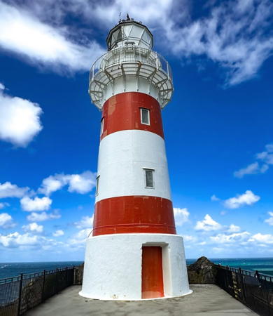
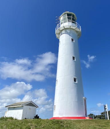
Cape Palliser Light, South Wairarapa, January 2013
Flickr Creative Commons photo by Kathrin & Stefan Marks


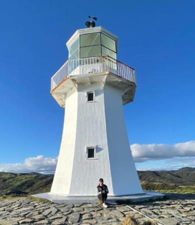
Pencarrow Sector Light, Lower Hutt, September 2007
Wikimedia Creative Commons photo by stanw

Hawke's Bay Region Lighthouses

Hawke Bay is a large bight on the southeast coast of North Island, extending about 100 km (60 mi) from the Mahia Peninsula to Cape Kidnappers. The Hawke's Bay Region encloses the bay and also extends southward along the east coast. Napier is the regional capital, and the region has a population of about 185,000.

Wairoa District Lighthouses
Table Cape
Date unknown. Active; focal plane 188 m (617 ft); three white flashes every 20 s. 3 m (10 ft) round concrete or fiberglass tower. No photo available but Google has a satellite view. Located on the northeastern cape of the Mahia Peninsula. Site status unknown. Operator: Maritime New Zealand. Admiralty K3969; NGA 4484.
#Portland Island (2)
1958 (station established 1878). Replaced. This was an 8 m (26 ft) square pyramidal steel tower with slatted daymark painted white. Scott Sambell's 2019 street view shows that the light (focal plane 187 m (614 ft); three white flashes every 20 s) is now on a square metal cabinet. Google has a satellite view. The original lighthouse was relocated to Wairoa (next entry). Resident keepers maintained the light until 1982. Located on Portland Island (Waikawa), just off the tip of the Mahia Peninsula, at the northern entrance to Hawkes Bay about 65 km (40 mi) southeast of Wairoa. Accessible only by boat; the island is a privately owned sheep farm. Site and tower closed. Operator/site manager: Maritime New Zealand. ARLHS NZL-042. Active light: Admiralty K3970; NGA 4488.
* Portland Island (1) (relocated to Wairoa)
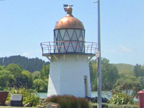
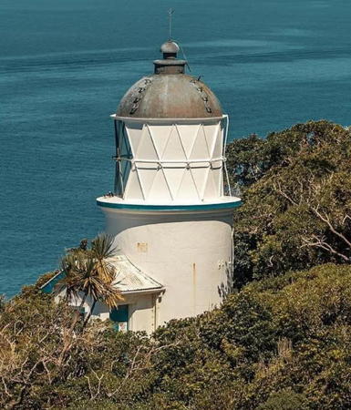
1878 (John Blackett). Inactive at its original site since 1958 but a continuous white light is displayed from sunset to midnight each night. 7 m (23 ft) hexagonal wood tower with lantern, copper dome and gallery, painted white. The lantern contains the original 2nd order Fresnel lens. The lighthouse was relocated in 1961 to Wairoa, where it is the town's best known landmark and historical site. Brendan Purdy's photo is at right, Philip Fierlinger has an excellent photo, Samantha Fan has a 2021 photo, Phil Rickerby has a 2008 closeup, Wikimedia has a photo, Google has a closeup street view, and Google has a satellite view. In 2016 a replica of the original auxiliary light was added to the tower; this light was used to warn mariners away from Bull Rock east of Portland Island. The lighthouse was relighted in April 2016 and later in that year it was repainted by volunteers. Located on the west side of the Wairoa River at the NZ 2 bridge, about 3 km (2 mi) north of the ocean. Site open, tower closed. Owner/site manager: Wairoa District Council. . ARLHS NZL-089.

Portland Island Light, Wairoa, January 2018
Flickr Creative Commons photo by Brendan Purdy

Napier City Lighthouses
Napier is a seaport known for exporting New Zealand products including apples, wine, and wool. The city has a population of about 70,000.
#Whirinaki Point (Whirinaki Bluff)
Date unknown. Demolished and removed in 2006. This light was described as a 16 m (52 ft) skeletal tower, painted with red and white horizontal bands. No photo available and Google's satellite view of the location shows no trace of the structure. A Google street view shows the bluff on which the light stood. Located on a bluff about 20 km (13 mi) north of Napier. Site status unknown. ARLHS NZL-057; ex-Admiralty K3980.
* Napier Southern Range Front
Date unknown. Inactive since 2006. 16 m (52 ft) square pyramidal wood skeletal tower with lantern and gallery, painted white. The seaward face of the lighthouse also carries a white slatted daymark. Werning's photo is at right, a 2012 photo is available, Simon Klaus has a photo of the two range lights, and Google has a 2022 street view and a satellite view. This was an approach range for Napier. Located off the Main North Road about 3.5 km (2.5 mi) north of Napier. Site open, tower closed. ex-Admiralty K3982.1; ex-NGA 4500.
* Napier Common Range Rear
Date unknown. Inactive since 2006. 21 m (69 ft) square pyramidal wood skeletal tower with lantern and gallery, painted white. The seaward face of the lighthouse also carries a slatted daymark painted white with a red vertical stripe. Simon Klaus has a photo of the two range lights and Google has a satellite view and a distant 2022 street view. Located 331 m (362 yd) west of the Southern front light. Site open, tower closed. ex-Admiralty K3982; ex-NGA 4504.
* [Westshore (Leading Light)]
2006. Active; focal plane 15 m (49 ft); flash every 10 s, white, red or green depending on direction. The tower also carries the South Pania Channel Directional Light (focal plane 14 m (46 ft); continuous white, red or green light depending on direction). 13 m (43 ft) post with a large rectangular gallery. Trabas has Boucher's photo and Google has a street view and a satellite view. This leading light replaced the former range lights in guiding ships to Napier. Located beside the Main North Road just north of the Napier Airport. Site open, tower closed. Operator: Napier Port. Admiralty K3981; NGA 4506.
Napier Southern Range Front Light
Napier Southern Range Front Light, Napier
photo copyright Malte Werning; used by permission
* [PEL 6 Westshore (Leading Light)]
Date unknown. Active; focal plane 17 m (56 ft); continuous white, red or green light. 17 m (56 ft) concrete mast. Google has a street view and a satellite view. Located close behind the Westshore School in Napier. Site open, tower closed. Operator: Napier Port. Site manager: Westshore School. Admiralty K3981.2; NGA 4515.
* Port Napier East Pier (Sulphur Point)
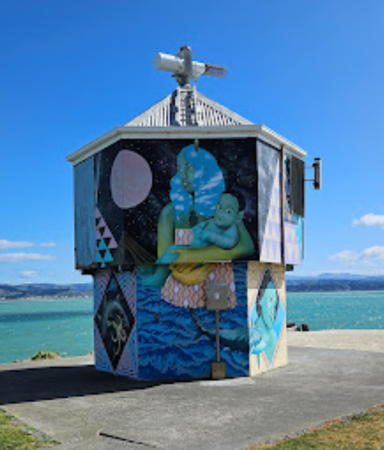
Date unknown. Active; focal plane 10 m (33 ft); continuous white, red or green light; also a red light, 2 s on, 2 s off. 5 m (17 ft) hexagonal harbor control kiosk, originally painted blue. Trabas has Boucher's photo (also seen at right), Jakub Kuk has a 2023 photo, and Google has a 2019 street view and a satellite view. When Arno Siering visited in 2018 he found the structure painted with decorative art work. Located on the east side of the entrance to the small boat harbor of Napier. Site open, tower closed. Operator: Napier Port. Admiralty K3981.5; NGA 4516.

Hastings District Lighthouse
* [Cape Kidnappers]
Date unknown. Active; focal plane 112 m (367 ft); two white flashes every 15 s. 4 m (13 ft) square cylindrical steel tower topped by a short mast. Though too small to be considered a real lighthouse, this little tower is well known as the site of a huge nesting colony of Australian gannets. Trabas has Jim Smith's closeup photo and Google has a street view and a satellite view. Frequently visited by ecotours. Located on the cape at the southern end of Hawkes Bay about 15 miles east of Hastings. Site open, tower closed. Operator/site manager: Maritime New Zealand. ARLHS NZL-009; Admiralty K3992; NGA 4564.

Central Hawke's Bay District Lighthouse
Blackhead Point
Date unknown. Active; focal plane 41 m (135 ft); two white flashes every 10 s. 4 m (13 ft) round concrete or fiberglass tower. No photo available but Google has a satellite view. Located on a remote headland about 80 km (50 mi) southwest of Cape Kidnappers. Site status unknown. Operator: Maritime New Zealand. Admiralty K3993; NGA 4568.

Napier East Pier Light, Napier
photo copyright Michael Boucher; used by permission

Wellington Region Lighthouses

Cook Strait (Te Moana-o-Raukawa) the passage between New Zealand's North and South Islands, is named for Capt. James Cook, who discovered it in 1770. West of Wellington the strait narrows to 23 km (14 mi) in width. Strong currents and rocky shoals make the passage a difficult one for navigators. Wellington, the capital of New Zealand, is located near the southernmost tip of North Island and just inside the eastern entrance to Cook Strait. The city has a population of 215,000 in the urban area and more than 400,000 in the metropolitan area. At latitude 41.3° south it is the southernmost national capital in the world. The Wellington Region, also called Greater Wellington, includes the entire southern peninsula of North Island and has a population of about 550,000.

Masterton District Lighthouse
* Castle Point
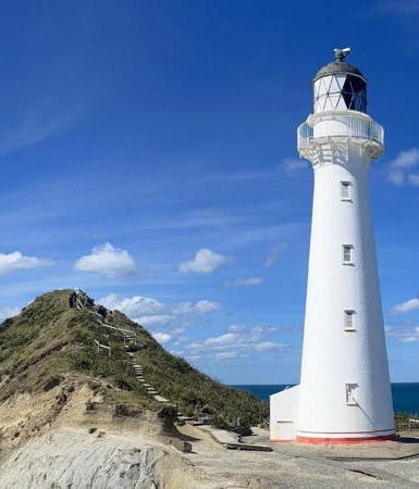
1913. Active; focal plane 52 m (170 ft); three white flashes every 30 s. 23 m (75 ft) round cast iron tower with lantern and gallery, painted white; lantern roof is gray. The original 2nd order Fresnel lens continues in use. Other light station buildings demolished. Kelly Mahoney's photo is at right, Trabas has Boucher's photo, Zachary Gleisner has a fine closeup photo, Keith Miller has a photo, a 2021 photo is available, Philipp Mielke has a beautiful street view, and Google has a satellite view. The lighthouse was prefabricated in Wellington. In 2001 there was a report the lighthouse might be deactivated, but this did not happen. The causeway connecting the station to the mainland was demolished in 2008 because it had become unsafe, but except during the highest tides it is still possible to reach the lighthouse on foot across a sandy flat. Located at the end of Castlepoint Road about 65 km (40 mi) southeast of Masterton on the Wairarapa (east) Coast. Parking provided. Site open, tower closed. Operator/site manager: Maritime New Zealand. . ARLHS NZL-016; Admiralty K3994; NGA 4572.

Carterton District Lighthouse
Honeycomb Rock
Date unknown. Active; focal plane 57 m (187 ft); white light, 2 s on, 8 s off. 4 m (13 ft) round metal tower. No photo available but Google has a satellite view. The Honeycomb Rock area is famous for its unusual rock forms; it is accessible by a popular but strenuous walking track. Located on the rugged Wairarapa coast, halfway between Castle Point and Cape Palliser. Site open, tower closed. Operator: Maritime New Zealand. Admiralty K3998; NGA 4576.

South Wairarapa District Lighthouse
Cape Palliser (Matakitakiakupe)
1897. Active; focal plane 78 m (256 ft); two white flashes every 20 s. 18 m (59 ft) round cast iron tower with lantern and gallery, painted with red and white horizontal bands (the only New Zealand lighthouse with this daymark). The original 2nd order Fresnel lens continues in use. The two keeper's houses are now private residences. A photo by Kathrin & Stefan Marks is at the top of this page, Aaron Leece has a 2018 closeup photo, Werning has a good photo, Walter Davis has a good closeup photo, Trabas has Jim Smith's distant view, Trevor Mordaunt has a spectacular street view from the top of the cape, and Google has a satellite view and a distant street view from below the lighthouse. Prefabricated in Wellington, the lighthouse marks the extreme southeastern tip of the North Island and the eastern entrance to Cook Strait and Wellington. The tower was repainted early in 2008, as seen in an April photo, and again in 2015. A gravel road reaches the light station; 4WD recommended. No parking is provided and there's a steep climb of 258 steps to the lighthouse. Site open if you can get there, tower closed. Operator/site manager: Maritime New Zealand. . ARLHS NZL-011; Admiralty K4000; NGA K4580.

Castle Point Light, Castlepoint, November 2023
Instagram photo
by Kelly Mahoney

Lower Hutt City: Wellington Eastern Approach Lighthouses
Baring Head (Ōrua-pouanui)
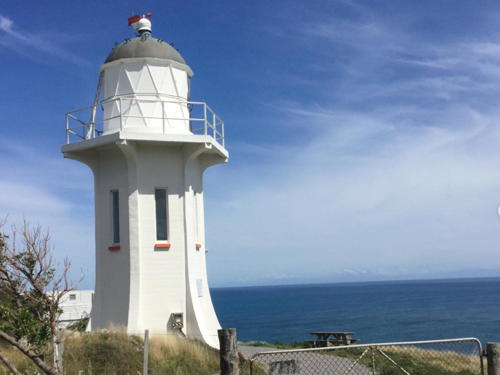
1935. Active; focal plane 87 m (286 ft); white light, 9 s on, 6 s off. 12 m (40 ft) octagonal concrete tower with six ribs, lantern, and gallery. Lighthouse painted white; lantern dome is gray. Weather station. A photo is at right, Eugene Metreveli has a 2018 closeup photo, Trabas has Boucher's photo, Nick Mumford has a lovely photo, another closeup photo is available, Luca van Gorkom has a street view from below the lighthouse, and Google has a satellite view. The last traditional lighthouse built in New Zealand, this tower replaced the older Pencarrow Head Light as the entrance light for the approach to Wellington. In 2005 the light was moved to an LED beacon mounted on the gallery. In 2010 the Greater Wellington Regional Council paid $1.75 million to purchase the light station for inclusion in the East Harbour Regional Park. The Friends of Baring Head was organized to support restoration of the station and its surroundings. The two keepers houses are being renovated for overnight accommodations. Renovations of the houses were underway in 2019-20 and one of them opened in December 2023. In 2023 New Zealand Heritage added the light station to the Heritage List. The steep headland of Baring Head (Ōrua-pouanui) commands a spectacular view across the entrance to Cook Strait. Located on a headland about 40 km (25 mi) southeast of Wellington. Accessible by a hiking trail from a trailhead off the Coast Road; allow three hours for a hike to the lighthouse and back. Site normally open (may be closed during restoration projects), tower closed. Operator/site manager: Maritime New Zealand. Site manager: Greater Wellington Regional Council. . ARLHS NZL-002; Admiralty K4004; NGA 4584.

Baring Head Light, Lower Hutt, December 2011
Wikimedia Creative Commons photo
by Pseudopanax
** Pencarrow (1) (Old Pencarrow Head)
1859. Inactive since 1935. 11.5 m (38 ft) tapered octagonal cast iron tower with lantern and gallery, painted white; lantern roof is black. Nowinna Pacaldo's 2023 photo is at right, a January 2006 photo shows the lighthouse freshly painted and apparently in excellent condition, Wikimedia has a closeup photo, Alister McKeown has a 2018 photo, James Lamb has a street view from the base of the tower, and Google has a satellite view. This is New Zealand's oldest lighthouse, designed by Colonial Engineer Edward Roberts, prefabricated in England by Woodside Ironworks, and installed by Edward George Wright. Deactivated in 1935 in favor of the Baring Head lighthouse, the lighthouse was transferred to the New Zealand Historic Places Trust (now Heritage New Zealand) in 1966. In June 2008 the Trust completed a project to restore the lantern roof. Located atop the headland in East Harbour Regional Park. Accessible by bicycle or by a hike of about two hours one way from Burdans Gate on the Pencarrow Coastal Road south of Eastbourne. Site open, tower generally closed. Owner/site manager: Heritage New Zealand. . ARLHS NZL-068.
* Pencarrow (2) (Pencarrow Sector)
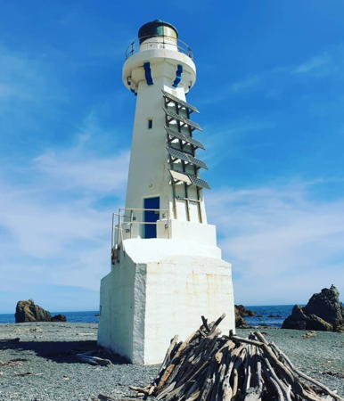
1906. Active; focal plane 18 m (60 ft); three flashes, red or white depending on direction, every 12 s. 17 m (56 ft) octagonal concrete tower with lantern and gallery. Entire lighthouse painted white. A photo is at the top of this page, Richard Mayston has a good closeup, a 2022 photo is available, Trabas has Thomas Philipp's photo, a photo showing both Pencarrow lighthouses is available, and Google has a satellite view. The lighthouse was repainted and refurbished in 2009. Built as a steel skeletal tower, this lighthouse was encased in concrete during the 1930s. Located on the beach below the original lighthouse; accessible by bicycle or by a hike of about two hours one way from Burdans Gate on the Pencarrow Coastal Road south of Eastbourne. Site open, tower closed. Owner/operator: Greater Wellington Harbours. Site manager: East Harbour Regional Park. . ARLHS NZL-039; Admiralty K4006; NGA 4588.

Lower Hutt City: Wellington Harbour Lighthouses
Wellington Harbour is a beautiful natural harbor roughly 10 km (6 mi) in diameter connected to Cook Strait by a 2 km (1.25 mi) wide passage between steep hills. The harbor was officially called Port Nicholson until 1984. The Māori name is Te Whanganui-a-Tara, the great harbour of Tara.

* [Hind Point Range Rear]
Date unknown. Active; focal plane 9 m (30 ft); white light, 1 s on, 1 s off. 6 m (20 ft) white octagonal metal tower. Sigrun Hreinsdottir has a street view and Bing has a satellite view. This range guides outbound vessels after they round Point Halswell (see below). The front light is on a buoy. Located on the Pencarrow Coast Road on the east side of the entrance passage. Site open, tower closed. Admiralty K4010.2.

1859 Pencarrow Light, Lower Hutt, June 2023
Instagram photo by Nowinna Pacaldo
Wellington Entrance Range Front
Date unknown (station established 1915). Active; focal plane 7 m (23 ft); quick-flashing white light. 4 m (13 ft) round cast iron lantern mounted on a square platform supported by pilings. Lantern painted white. Trabas has Boucher's photo, Myhre has a foggy photo and Bing has a satellite view. Located on the east side of the Wellington entrance channel about 2 km (1.25 mi) east of the Seatoun neighborhood of the city. Accessible only by boat. Owner/operator: Greater Wellington Harbours. Site open, tower closed. Admiralty K4010; NGA 4592.
Hope Shoal (Wellington Entrance Range Rear) (2)
Around 2010 (station established 1915). Active; focal plane 17 m (56 ft); white, red, or green light, depending on direction, 2 s on , 2 s off. 17 m (56 ft) round steel caisson topped by a round barbell-shaped steel tower. Lighthouse painted with a daymark in the form of orange and yellow horizontal bands. Trabas has Thomas Philipp's photo, Myhre has a foggy photo and Google has a satellite view. The original lighthouse was described as a steel cylinder. Located in Somes Sound about 2.1 km (1.34 mi) north of the front light and 700 m (770 yd) southwest of Makaro (Ward) Island. Accessible only by boat. Owner/operator: Greater Wellington Harbours. Site open, tower closed. Admiralty K4010.1; NGA 4596.
* Matiu/Somes Island (2)
1900 (station established 1866). Active; focal plane 29 m (95 ft); light on 4 s, off 6 s: white, red, or green depending on direction of approach. Approx. 9 m (30 ft) round cylindrical brick tower with lantern and gallery, attached to a small workshed. Lighthouse painted white; lantern roof is black. The other light station buildings were demolished after automation in 1924. Matt Lamont's photo is at right, David Leverton has a closeup photo, a 2011 photo is available, Alex Paterson has a 2020 view of the lighthouse looking across the harbor, Trabas has Boucher's view, and Google has a satellite view and a closeup street view. The original light here, a small octagonal cast iron tower, was relocated in 1903 to Tuhawaiki Point near Timaru on South Island. Matiu/Somes Island, formerly a quarantine station for both people and animals, was closed to the public until 1995. Now it is a well known ecological reserve and sanctuary for native wildlife, accessible from downtown Wellington by passenger ferry. Located on the south side of the island in Wellington Harbour; accessible from the Matiu/Somes Island Island Loop Track. Site open, tower closed. Owner/operator: Greater Wellington Harbours. Site manager: N.Z. Department of Conservation (Matiu/Somes Island Sanctuary). ARLHS NZL-047; Admiralty K4014; NGA 4620.
 

Matiu/Somes Island Light, Wellington Harbour, January 2008
Wikimedia public domain photo
by Matt Lamont

Wellington City: Wellington Harbour Lighthouses
Jerningham Point
Date unknown. Active; focal plane 6 m (20 ft); quick-flashing red light. 6 m (20 ft) round white concrete tower. Myhre has a photo, Trabas has Boucher's photo, and Google has a street view and a satellite view. Located off the tip of the promontory sheltering the east side of Wellington's inner harbor. Accessible only by boat. but easily seen from Roseneath Memorial Park on the point. Owner/operator: Greater Wellington Harbours. Site open, tower closed. Admiralty K4024; NGA 4688.
* Point Halswell
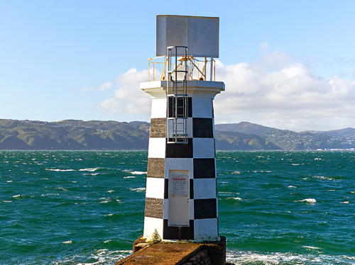
Date unknown. Active; focal plane 8 m (26 ft); white flash every 3 s. 8 m (26 ft) octagonal concrete tower with gallery, painted in a black and white checkerboard pattern. A photo is at right, Werning has a photo, Matt Feildo also has a photo, Shannon Doyle has a closeup photo, Trabas has Boucher's photo, and Google has a street view and a satellite view. Located just off the tip of the Miramar Peninsula, which projects northward into Wellington Harbour. Accessible by road. Site open, tower closed. Owner/operator: Greater Wellington Harbours. . ARLHS NZL-061; Admiralty K4018; NGA 4708.
Steeple Rock
Date unknown. Active; focal plane 7 m (23 ft); red or white light, depending on direction, 3 s on, 3 s off. 8 m (26 ft) octagonal tower colored white with a narrow red horizontal band. Trabas has Boucher's photo, Liz Ritchie has a distant view, another photo is available, Daniele Alemagna has a very distant street view from shore, and Google has a satellite view. Located on the west side of the entrance channel to Wellington Harbour. Accessible only by boat. Site open, tower closed. Owner/operator: Greater Wellington Harbours. Admiralty K4011; NGA 4604.

Point Halswell Light, Wellington, February 2023
Instagram photo by Lighthouse Buffs

Wellington City: Wellington Western Approach Lighthouses
Karori Rock
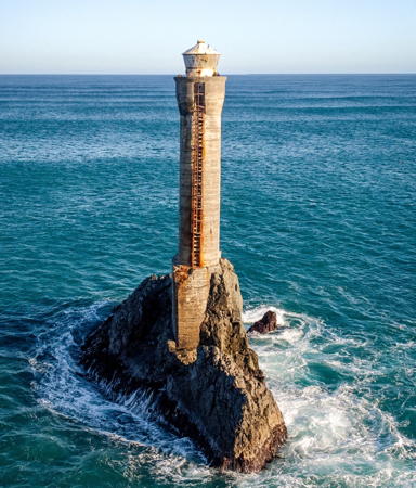
1915. Inactive since 1996. 20 m (65 ft) round cylindrical concrete tower with lantern. One of New Zealand's first automated lighthouses, this tower was built after the steamer Penguin wrecked on the rock in 1909. Difficult to service or repair due to its highly exposed location, it was replaced by the Tongue Point Light in 1996. The tower has a definite lean and is called "Wellington's leaning lighthouse." Ross Dredge's drone view is at right, photo by Wade Tregaskis shows the lean, Chris Bryant also has a photo, and Google has a satellite view and a street view from the beach. Located on an islet in Cook Strait off the western entrance to Wellington Harbour. Accessible only by boat; there are distant views from Tongue Point. Owner/site manager: Maritime New Zealand. . ARLHS NZL-031.
Tongue Point
1996. Active; focal plane 44 m (144 ft); flash every 4 s, alternating red and white. 4 m (13 ft) square cylindrical steel tower topped by a short mast. Angus Prain has a photo, Trabas has Boucher's distant view and Google has a satellite view and a very distant street view from the beach. The lighthouse replaced the Karori Rock Light. The area is famous for its seal colonies. Located on a bluff above Cook Strait southwest of Wellington. Accessible by 4WD. Site open, tower closed. Operator/site manager: Maritime New Zealand. ARLHS NZL-064; Admiralty K4062.1; NGA 4717.
[Ohau Point]
1996. Active; focal plane 104 m (341 ft); two white flashes every 15 s. 4 m (13 ft) square cylindrical steel tower topped by a short mast. Google has a satellite view. Located on a promontory marking the east side of the entrance to the narrowest section of Cook Strait. Site status unknown. Operator/site manager: Maritime New Zealand. ARLHS NZL-060; Admiralty K4066.2; NGA 4728.

Karori Rock Light, Wellington, June 2021
Instagram photo by Ross Dredge

Porirua City Beacon
[Mana Island]
1865. Inactive since 1877. The original lighthouse, seen below, was relocated to Cape Egmont in 1881 after being deactivated in favor of The Brothers Light (see South Island). The brick foundation of the lighthouse remains; a square pyramidal daymarker has been built on it. Charles Jarvie has a closeup photo and Google has a satellite view. Mana Island is a 3 km (2 mi) long island located about 3 km (2 mi) offshore and 8 km (5 mi) west of the entrance to Porirua harbor. Located at the northwest point of the island, accessible by a popular hiking trail. Site open. Site manager: N.Z. Department of Conservation (Mana Island Scientific Reserve). ARLHS NZL-032.

Manawatū-Whanganui Region (South Taranaki Bight) Lighthouses

The Manawatū-Whanganui Region is mostly and inland area, including a large part of the southern North Island. At its southern end it has a coastline facing west on the broader reaches of Cook Strait.

Whanganui District Lighthouses
Whanganui (Wanganui) River North Head Range Front
Date unknown. Active; focal plane 16 m (52 ft); continuous red light. 7 m (23 ft) square pyramidal skeletal tower carrying a white slatted daymark and a large black "X" at the top. Trabas has Boucher's photo and Google has a 2020 street view and a satellite view. This is the entrance range for Whanganui, a seaport of about 45,000 residents, known for its shipbuilding. The city was long known as Wanganui; the spelling was changed officially in 2009 but the older spelling is still used by most residents. Located on a south-facing bluff on the west side of the river entrance. Site status unknown. Admiralty K4078; NGA 4752.
* Whanganui (Wanganui) River North Head Range Rear
Date unknown. Active; focal plane 23 m (75 ft); continuous red light. 9 m (30 ft) triangular pyramidal skeletal tower carrying a white slatted daymark and a large circular slatted daymark at the top. Trabas has Boucher's photo and Google has a 2020 street view and a satellite view. Located at the end of Kirk Street, 76 m (250 ft) northeast of the front light. Site open, tower closed. Admiralty K4078.1; NGA 4756.

Taranaki Region Lighthouses

The Taranaki Region occupies a triangular peninsula projecting into the Tasman Sea from the west coast of North Island. The region surrounds and is named for the dormant vokcano of Mount Taranaki (named Mount Egmont by Capt. Cook), which rises in a cone to an elevation of 2518 metres (8261 ft).

South Taranaki District Lighthouses
* [Patea River Entrance]
Date unknown. Active; focal plane 41 m (135 ft); white flash every 3 s. 5 m (17 ft) mast atop a 1-story square concrete base. Trabas has Boucher's photo and Google has a street view and a satellite view. Located atop a bluff off Pilot Station Road on the east side of the Patea River. Site open, tower closed. Admiralty K4084; NGA 4780.
* Cape Egmont
1865 (relocated to this site in 1881). Active; focal plane 33 m (109 ft); white flash every 8 s. 20 m (65 ft) round cast iron tower with lantern and gallery, painted white; lantern roof is black. The original 1st order Fresnel lens, removed in 2000, is now displayed in a 2/3 replica of the lighthouse (see below under faux lighthouses). The keeper's house is now a private residence. Kate Hall's photo is at right, Luke Taylor has a 2023 photo, Satrajit Basu has a lovely 2020 photo, Mike Hollman has a fine 2009 photo, Trabas has a closeup photo, Mel Hodgkinson has another photo, and Google has a street view and a satellite view. Mount Taranaki stands behind the lighthouse in the Hollman and Brophy photos. Prefabricated in England by McLean, Simpson and Co., the lighthouse was first constructed on Mana Island near Wellington, but its light was confused with that of the Pencarrow Head Light. The tower was relocated to Cape Egmont in 1877 but it was not activated there until 1881. In March and April 2022 a project recoated the exterior and made repairs to the cast iron joints; Jessica Neve has a photo taken during this work. A sibling of the Tiritiri Matangi Light, the lighthouse marks the southwesternmost point of North Island and the northwestern entrance to Cook Strait. Located at the end of Cape Road near Pungarehu. Site open, tower closed. Operator/site manager: Maritime New Zealand. . ARLHS NZL-007; Admiralty K4088; NGA 4788.
[Puniho]
Date unknown. Active; focal plane 8 m (26 ft); three white flashes every 10 s. 4 m (13 ft) square metal cabinet. No photo available but Google has a satellite view. Located at the tip of a headland about 10 km (6 mi) north of Cape Egmont. Site status unknown. Operator/site manager: Maritime New Zealand. ARLHS NZL-090; Admiralty K4089; NGA 4786.

New Plymouth City Lighthouses
Mikotahi (Port Taranaki, New Plymouth)
Date unknown. Apparently inactive; previously listed with focal plane 30 m (98 ft); two white flashes every 5 s. Approx. 12 m (39 ft) hexagonal skeletal tower with a large white structure at the top. Trabas has Boucher's view and Google has a satellite view. The largest city of the Taranaki Region, New Plymouth has a population approaching 90,000. Its port, known as Port Taranaki, is the only deepwater port on the west coast of North Island. Located atop a prominent rock on the waterfront of New Plymouth. Site and tower closed. Operator/site manager: Port Taranaki. ARLHS NZL-059; ex-Admiralty K4090; NGA 4804.

Sunset at Cape Egmont Light, South Taranaki, November 2022
Instagram photo by Kate Hall

Information available on lost lighthouses:

Notable faux lighthouses:

Adjoining pages: North: Northern North Island | South: South Island

Return to the Lighthouse Directory index | Ratings key

Posted April 2, 2004. Checked and revised December 17, 2023. Lighthouses: 26. Site copyright 2023 Russ Rowlett and the University of North Carolina at Chapel Hill.