Lighthouses of the Philippines: Northeast Luzon and Batanes

The Republic of the Philippines (Pilipinas in Filipino) includes more than 7600 islands stretching over 1750 km (1100 mi) of the western Pacific and separating the Philippine Sea on the east from the South China Sea on the west. The largest islands are Luzon at the northern end of the country and Mindanao at the southern end. As of 2020 the population of the country was about 109 million.

The archipelago was a Spanish colony until the Spanish-American War of 1898 brought the islands under U.S. administration. Japan occupied the islands during World War II (1942-45) and the country became independent shortly thereafter (1946).

The country is divided into 17 regions and subdivided into 81 provinces. Luzon dominates the northern half of the Philippines and includes seven of the regions. This page describes lighthouses of northeastern Luzon: the provinces of Batanes, Cagayan, and Islabela in the Cagayan Valley Region, Aurora in the Central Luzon Region, and the east coast of Quezon province in the Calabarzon Region.

Filipino and English are official languages in the Philippines. In Filipino a lighthouses is called a parola or farola; an island is an isla or pulo. Many English maritime terms have been adopted into Filipino, including cape, bay, and port, and the names of historic lighthouses are often retained in their Spanish forms.

Lighthouses in the Philippines are maintained by the Marine Safety Services Command of the Philippine Coast Guard. Notices to Mariners are posted by the National Mapping and Resource Information Agency (NAMRIA).

ARLHS numbers are from the ARLHS World List of Lights. PCG numbers are the Philippines Light List numbers, where known. Admiralty numbers are from volume F of the Admiralty List of Lights & Fog Signals. U.S. NGA List numbers are from Publication 112.

General Sources
Lighthouses in the Philippines
Photos and observations in blog entries by Loyd Martinez.
Online List of Lights - Philippines - Luzon and Luzon Strait
Photos by various photographers posted by Alexander Trabas.
Lighthouses in the Philippines
Wikipedia article, with links to articles on several of the individual lighthouses.
Spanish Lighthouses of the Philippines
The Directory's own list of the Spanish light stations, with notes on their current status.
Lighthouses in the Philippines
Photos by various photographers available from Wikimedia.
World of Lighthouses - Philippines
Photos by various photographers available from Lightphotos.net.
Leuchttürme Asiens auf historischen Postkarten
Historic postcard images posted by Klaus Huelse.


Mahatao East Light, Batanes, March 2018
Instagram photo by John Victor Aclan

Cagayan Valley Region (North and Northeast Coast) Lighthouses

Batanes Province Lighthouses
The Batanes, or Batan Islands, are located in the Luzon Strait between Taiwan and Luzon. Lying about 160 km (100 mi) north of the Luzon mainland, they are readily accessible by air from Manila. In 2000 the provincial government of Batanes announced a plan to build three lighthouses, primarily as tourist attractions in the islands and secondarily as navigational aids.
[Yami (Amianan Island) (2?)]
2014(?). Active (?); focal plane 20 m (66 ft); white flash every 5 s. 6 m (20 ft) metal post. Joseph Emmanuel Magallanes has a 2021 photo but the mast is not seen in Google's satellite view of the station. Questions arise here. PCG awarded a contract to build a lighthouse in 2014, but apparently this did not go well and in 2016 it advertised for a contractor to reconstruct a lighthouse. NGA lists a white concrete tower, form and height unknown. Google has a distant satellite view of the Admiralty location, high on the ridge at the northern tip of the island, but no lighthouse is seen there. Yami is the northernmost island of the Philippines. Its name has been spelled Y'Ami, Dihami, and Diami; Wikipedia calls it Mavulis, and NGA has it as Amianan. The island is uninhabited but the Philippine Navy and Coast Guard maintain a small station as an assertion of sovereignty. Located on the northern tip of the island. Accessible only by boat. Site open, tower closed. PCG-0000; Admiralty F2823; NGA 13992.
* Valanga
2022. Active; focal plane unknown; white flash every 5 s. Approx. 12 m (39 ft) round tapered stone tower with a domed lantern. PCG has a photo, a drone view is available, and Google has a satellite view. The light was commissioned by PCG in December 2022. Located on heights southeast of the Valanga port on Itbayat, northernmost of the inhabited Batanes Islands. Site open, tower closed. Admiralty F2822.8.
*** Basco (Naidi Hills)
2003. Active; focal plane unknown; white flash every 4 s. Approx. 20 m (66 ft) round concrete tower with lantern and gallery, mounted on a round rubblestone base and attached to a small 1-story rubblestone "cottage" that serves as a visitor entrance. Lighthouse painted white with red trim; lantern painted red. NGA and PCG formerly listed the light as having a red flash, but the lamp is clear. A 2020 photo by Bibiano Reyes is at right, Elmar Lumayog has a 2022 closeup, another good photo is available, Bing Ramos's photo has a view of the location, and Google has a street view and a satellite view. Located on a hill on the north side of Basco, the principal town of Batan Island. Accessible by road or by a walk of about 1.2 km (3/4 mi) from the town. Site open, tower open for climbing but no schedule is available. . PCG-0001; Admiralty F2822.5; NGA 13990.

Basco Light, Batanes, June 2020
Instagram photo
by Bibiano Reyes
* Mahatao
Around 2018. Active; focal plane about 20 m (66ft); two white flashes every 10 s. Approx. 18 m (59 ft) round unpainted concrete tower with lantern and gallery. Robert Deluria has a 2019 photo, Christian Dale Tabag has a 2022 photo, and Google has a satellite view. Located on the waterfront of the village of Mahatao, on the northwest coat of Batan Island. Site open, tower closed. Admiralty F2822.4.
* Mahatao East (Diura)
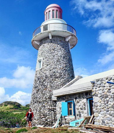
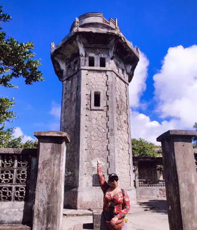
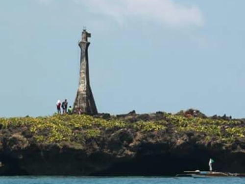
2004. Active; focal plane unknown; two white flashes every 10 s. Approx. 18 m (59 ft) hexagonal concrete tower with lantern and gallery, mounted on a hexagonal rubblestone base and attached to a small 1-story rubblestone "cottage" that serves as a visitor entrance. Lighthouse painted white with red trim; lantern painted red. John Victor Aclan's 2018 photo is at the top of this page, Xavier Immanuel Ignacio has a nice photo of the station, Oggie Ramos has a closeup, Reynaldo De Guzman has a 2019 photo, and Google has a street view and a satellite view. This lighthouse stood inactive for many years, but the Admiralty announced it as operating in May 2016. The light was commissioned by PCG in December 2022. Located on a hill on the east side of Batan Island opposite Mahatao, about 5 km (3 mi) southeast of the Basco lighthouse. Site open, tower status unknown. . PCG-0733; Admiralty F2822.3.
Imnajbu Point (Batan Island Southeast)
Date unknown. Active; focal plane unknown; continuous red light. This appears to be a tall communications tower. Google has a very distant street view but the tower is not seen in Google's indistinct satellite view. Site status unknown. PCG-0002; Admiralty F2822; NGA 13988.
* Ivana
2022. Active; focal plane unknown; two green flashes every 10 s. Approx. 16 m (52 ft) octagonal concrete tower with lanern and gallery centered on a 1-story octagonal stone building. Tower painted white with red trim. Neville-Jay Ramirez has a closeup 2024 photo and a photo of the light in action, another closeup photo and a more distant view are available and Google has a satellite view. The light was commissioned by PCG in December 2022. Located at Ivana, a municipality at the southwestern end of Batan Island. Site open, tower closed. Admiralty F2821.
 
* Sabtang North (Asked Point)
2006. Active (?); focal plane unknown; two red flashes every 10 s. Approx. 18 m (56 ft) round rubblestone tower with lantern and gallery. The tower is unpainted; the watch room and trim are painted white and the lantern red. A 2019 photo is at right, Nilesh Korgaokar has a 2023 photo and Google has a street view and a satellite view. An April 2007 photo is available, also an October 2007 closeup and an August 2008 photo by Christie Manguiat. An adjoining rubblestone cottage had not been completed as of spring 2007; evidently the funds to complete the cottage ran out. A 2011 photo shows the cottage finally roofed .The light was not accepted by PCG until December 2022. Sabtang Island is a short distance south of Batan Island. Located on a rocky promontory on the north side of Sabtang village, on the northeast side of the island. Site open, tower appears closed. . PCG-0004; Admiralty F2820; NGA 13991.
[Chavayan]
Date unknown. Active; focal plane unknown; white flash every 5 s. Approx. 15 m (49 ft) skeletal mast. Myk Malag has a distant street view and another very distant view is available, but the tower is not seen in Google's satellite view. Located on a spectacular headland at the southeastern tip of Sabtang. Site status unknown. Admiralty F2819.5; NGA 13991.5.
Balintang Island
Date unknown. Active; focal plane about 60 m (200 ft); white flash every 10 s. Approx. 10 m (33 ft) round white concrete tower. No photo available and trees hide the tower in Google's satellite view of the location. Balintang is an uninhabited island in the Balintang Passage, roughly halfway between the Batanes and Babuyan Islands. Accessible only by boat. Site and tower closed. PCG-0005; Admiralty F2819; NGA 13985.

Sabtang North Light, Sabtang, June 2018
Instagram photo by Hazel Jo Ann

Cagayan Province Lighthouses
* Calayan Island (Nagudunran Point) (1)
Date unknown. Inactive since about 2006 and overturned at least by 2012. Approx. 14 m (46 ft) round barbell-shaped white fiberglass tower. A May 2021 video shows the lighthouse overturned and lying on the ground. Google has a satellite view. Calayan is the largest of the Babuyan Islands, which lie in the Luzon Strait off the north coast of Luzon. Located on the southeastern tip of the island. Accessible by a rather challenging hike. Site open, tower closed. .
* Calayan Island (Nagudunran Point) (2)
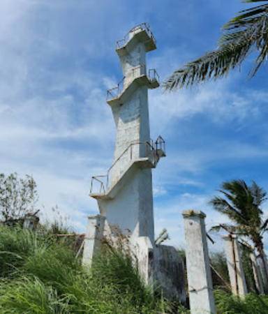
Around 2013. Active; focal plane unknown; white flash every 5 s. Approx. 12 m (39 ft) round concrete post with a stairway spiraling around the tower. Dong Perez has a 2017 closeup photo, Gerald Narag has a photo, Mark Ico has a distant view, Joseph Emmanuel Magallanes has a 2021 photo, and Google has a satellite view. Located on the slope below the current lighthouse. Site open and the tower can be climbed. Admiralty F2818.8; NGA 14146.
Pata Point (2)
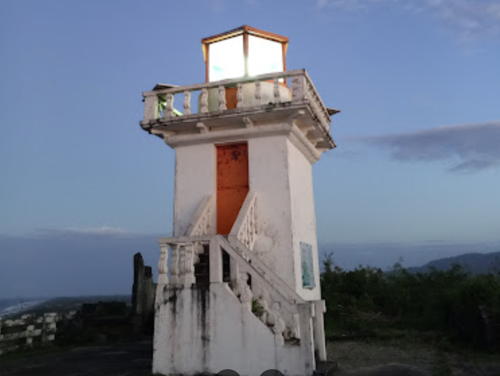
Date unknown (station established about 1909). Active; focal plane 62 m (203 ft); white flash every 5 s. 6.5 m (21 ft) square concrete tower with lantern and gallery, painted white; lantern painted black. Feitan Portor's 2024 photo is at right, Jess Balmores de la Cruz has a 2019 photo, Lhai Martinez has a 2019 closeup, and Google has a satellite view. Joan Marie Agnes's 2022 closeup shows the tower in need of paint but a modern LED lens in the lantern. This appears to be a historic light station with several ruined buildings; more information is needed on its history. A 1919 Coast Pilot describes the original light as a lantern atop a "small concrete cottage." It is perched atop a giant monolith that is the only conspicuous landmark on an otherwise low and sandy coastline. Located above the beach about 10 km (6 mi) east of Claveria. Site status unknown. PCG-0012; Admiralty F2724; NGA 14004.

Pata Point Light, Aparri, January 2024
Google Maps photo by Feitan Portor
#Linao Point (2?)
Date unknown (station established 1896). Inactive but listed with focal plane 11 m (36 ft); white flash every 5 s. NGA describes this light as a 9 m (30 ft) "white metal tower and dwelling." This sounds like a description of the original lighthouse, a typical French tourelle, prefabricated in Paris by Sautter Lemonier & Cie. Wikimedia has a 1903 photo that shows the lighthouse just off the beach. Manuel Noche visited this site around 2002 and found only rubble in the surf, but we don't know if these remains were of the French lighthouse or of a later replacement. PCG recently described the current tower as "steel," suggesting a mast, and a 2015 street view shows a mast that could have carried a light. A 2023 street view shows only a short fragment of the mast on its concrete base. There's no evidence of a light anywhere near the listed location at the present time. Located on the west side of the entrance to the Cagayan River opposite Aparri on the north coast of Luzon. Site open. ARLHS PHI-085; PCG-0011; Admiralty F2728; NGA 14008.
* Aparri (Cagayan River Entrance)
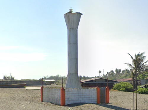
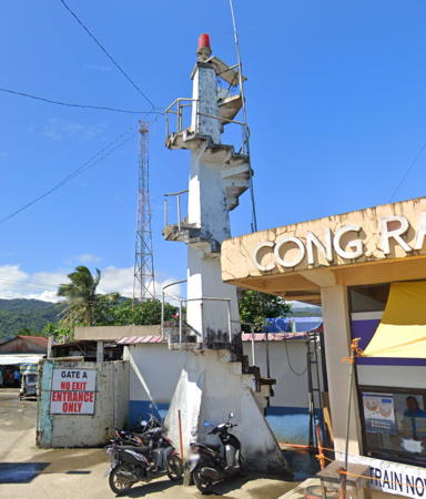
Date unknown. Active; focal plane 11 m (36 ft); white flash every 5 s. 9 m (30 ft) round barbell-shaped tower, painted white. A portion of Google's 2023 street view is at right, Ralf Tammocalao has a 2014 photo, a November 2008 photo is available, and Google also has a satellite view. This light replaces the historic Linao Point Light (previous entry) in marking the mouth of the Cagayan River, the longest river of the Philippines. Located on the east side of the entrance to the Cagayan River in Aparri. Site open, tower closed. PCG-0010; Admiralty F2728.5; NGA 14009.

Aparri Light, Aparri, May 2023
Google Maps street view
* Buguey
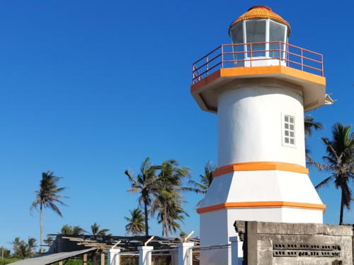
Date unknown. Active; focal plane about 12 m (39 ft); two red flashes every 5 s. Approx. 9 m (30 ft) 2-stage white concrete tower with lantern and gallery, the lower stage octagonal and the upper stage round. Jo Carlo Chan's 2024 photo is at right and Google has a satellite view. Located on the beach in Buguey, a village about 25 km (15 mi) east southeast of Aparri. Site open, tower closed. PCG-0830; Admiralty F2728.8.
* Port Casambalangan (Port Irene)
Date unknown. Active; focal plane unknown; green flash every 5 s. Approx. 7 m (23 ft) white concrete post with a stairway spiraling around the tower. Google has a 2024 street view and a satellite view. Located beside the Dugo-San Vicente Road on a headland just south of the Villa Angelo Beach Resort, about 8 km (5 mi) south of Santa Ana. Site appears open, tower closed. PCG-0009; Admiralty F2729; NGA 14012.
* Palawig (Palauig)
Date unknown. Active; focal plane about 9 m (30 ft); white flash every 5 s. Approx. 9 m (30 ft) slender square white concrete tower with an external concrete stairway winding around the tower. No closeup photo available but Google has a very distant 2024 street view and an indistinct satellite view. Located on the north side of the mouth of the Palawig River in Santa Ana. Site open, tower closed. PCG-0008; Admiralty F2730.5; NGA 14014.
Port San Vicente
Date unknown. Active; focal plane 9.5 m (31 ft); red flash every 5 s. 9.5 m (31 ft) white concrete post centered on a robust pyramidal base. No closeup photo available but Google has an indistinct satellite view and a very distant 2024 street view. San Vicente is a fishing port at the tip of the peninsula opposite Palaui Island and Cape Engano (next entry). Located at the tip of a shoal across from the San Vicente waterfront. Accessible only by boat. Site open, tower closed. PCG-0007; Admiralty F2730; NGA 14016.
 

Buguey Light, Buguey, June 2024
Google Maps photo by Jo Carlo Chan
 
Cape Engaño
1893 (Spanish). Active; focal plane 100 m (327 ft); white flash every 5 s. 14.5 m (47 ft) octagonal cylindrical stone tower, painted white, attached to 1-story stone keeper's house. Lantern removed and replaced with a solar-powered light. Gravely endangered. The tower seems reasonably sound but the keeper's houses and other light station buildings have fallen into ruin. Kim Cabrera's 2023 photo is at right, Fan Xiao has a 2019 drone view, Mart Renier Bagullo has a good 2015 photo, a 2010 photo is available, Wikimedia has many photos including a historic photo, taken in 1904, Rudel Saldiver has a street view from below the lighthouse, and Google has a satellite view of the station. Free-lance author Jacqueline Ong visited in the summer of 2008 and found the lighthouse seriously deteriorated. In March 2010 the National Museum declared the station to be an "important cultural property," which qualifies it for federal restoration funding. The lighthouse stands at the extreme northeastern corner of the Philippines and is a traditional landfall for ships arriving from the Pacific; it marks the eastern entrance to the Babuyan Channel, which provides the shortest route around the north end of Luzon. Located at the northern end of Palaui Island. Accessible only by boat. Site open, tower open but possibly dangerous. . ARLHS PHI-013; PCG-0006; Admiralty F2732; NGA 14020.
Caringtan Point (Alegan)
2016. Active; focal plane at least 30 m (98 ft); white flash every 5 s. Approx. 10 m (33 ft) white concrete tower. No photo available but Google has a satellite view. Located on the easternmost point of the Santa Ana peninsula at the northeastern corner of Luzon. The area is quite wild. Site status unknown. PCG-0832; Admiralty F2733.

Isabela Province Lighthouses
* Divilacan Bay (Maconacon, Aplaya)
Date unknown. Active; focal plane about 15 m (49 ft); white flash every 5 s. Approx. 12 m (39 ft) round barbell-shaped white fiberglass tower. Davison Baldos has a photo and Google has a fuzzy satellite view. Located on a densely forested point sheltering the fishing port of Maconacon. Site status unknown. PCG-0581; Admiralty F2735; NGA 14007.
Palanan Point (Isabela)
Date unknown. Active; focal plane unknown; white flash every 5 s. Approx. 12 m (39 ft) round barbell-shaped white fiberglass tower; this light is apparently a twin of the Davilacan lighthouse. A 2024 view is available and Google has a distant satellite view. Located on Palanan Point, marking the entrance to Palanan Bay; this is the easternmost point on Luzon's northeast coast. The remote location is accessible only by boat. Site status unknown. Admiralty F2737; NGA 14006.

Cape Engaño Light, Cagayan, December 2023
Instagram photo by Kim Cabrera

Central Luzon Region East Coast Lighthouses

Aurora Province Lighthouses
[Dinapigui]
Date unknown. Active; focal plane unknown; red flash every 5 s. 6 m (20 ft) white steel pole. Romel Baclig has a 2022 photo and Google has a satellite view of the location. Located on a bluff at Dinapigui just south of the provincial border. Site open, tower closed. PCG-0630; Admiralty F2740.
Tarigtig Point (Dilasag Bay)
Date unknown. Active; focal plane unknown; white flash every 5 s. Approx. 10 m (33 ft) white concrete tower with a stairway spiraling around the tower. No photo available but Google has a satellite view. Located on a sharp promontory sheltering Dilasag Bay. Site status unknown. PCG-0853; Admiralty F2740.5.
Cape San Ildefonso (Macose)
Date unknown. Active; focal plane at least 70 m (230 ft); white flash every 5 s. Approx. 15 m (49 ft) white concrete tower with a stairway spiraling around the tower. A photo is available, the same photographer has another view, Lucyl Riojean has a 2020 closeup, a 2018 drone view is available, Arwin Francis Guinto has a view from the sea, and Google has a satellite view. Located at the end of a sharply pointed peninsula in northern Aurora. Accessible by a hiking trail. Site open, tower closed. PCG-0836; Admiralty F2741.
* Baler (Sabang Beach)
Date unknown. Active; focal plane about 10 m (33 ft); red flash every 5 s. 9 m (30 ft) slender square concrete tower with an external concrete stairway winding around the tower. Jessie Jamisola has a 2023 photo, Gerard Casteneda has a 2010 photo, a closeup of the light in action is available, and Google has a closeup 2023 street view and an indistinct satellite view. Located on the beach to the west of the harbor entrance at Baler, a beach resort and the capital of Aurora province. Site open and there's no obstacle to climbing the stairway of the tower. PCG-0105; Admiralty F2742; NGA 14024.
Zabali (Cape Encanto, Baler) (2)
Date unknown. Active; focal plane unknown; white flash every 5 s. Approx. 16 m (52 ft) square white concrete tower with a stairway spiraling around the tower. Sherwin Salarzon has 2023 photo, Sotero Pineda has a 2017 photo, Marvin Butchayo has a street view, and Google has a satellite view. This lighthouse apparently replaced an older light; we need information on its history. This is a landfall light located high on a prominent cape about 10 km (6 mi) east of Baler. Site open, but reaching it requires a scramble up a steep slope. The tower can probably be climbed. PCG-0834; Admiralty F2742.2.
Dikapinisan Point
2016. Active; focal plane about 13 m (43 ft); red flash every 5 s. 10 m (33 ft) "concrete structure," according to the Admiralty announcement; apparently a white concrete tower with a stairway spiraling around the tower. The lighthouse is seen near the left edge of Patrick Bergsrud's distant aerial view and Google has a satellite view. Located on the beach in Dikapinisan, a fishing villageon the wild coast of the Mingan Mountains about 30 km (19 mi) south of Baler. Site status unknown. Admiralty F2742.4.
Agria Point (Dingalan)
Date unknown. Active; focal plane unknown; white flash every 5 s. Approx. 12 m (39 ft) square white concrete tower with a stairway spiraling around the tower. A 2024 photo is at right, Eric Corpuz has a 2017 street view seen at right, Marloun Tabios has a 2019 photo, a closeup photo (more than halfway down the page) is available, Marben Solania has a 2017 drone view, and Google has a satellite view. This is a landfall light located high on a prominent cape about 10 km (6 mi) southeast of Dingalan. Site open, but reaching it requires a substantial hike. The tower can probably be climbed. PCG-0833; Admiralty F2742.5.

Agria Point Light, Dingalan, September 2024
Google Maps photo by Bañaco, Princess C
 

Calabarzon Region East Coast (Northern Quezon Province) Lighthouses

Quezon Province spans the narrow waist of Luzon. Lighthouses on the south coast of the province are described on the Southwest Luzon page.

Polillo Islands Lighthouses
Polillo Island is a large island off the north coast of Quezon Province. The island is about 50 km (30 mi) long and has a population of about 65,000. Patnanungan and Jomalig are smaller islands in a chain extending southeastward from Polillo. The island chain forms the northern border of Lamon Bay.
* Polillo Range Rear (2)
Date unknown. Active; focal plane 17.5 (57 ft); continuous red light. 16.5 m (54 ft) white concrete tower with a stairway spiraling around the tower. Elmer Culata has the street view at right and Ardjel Dejaño has a 2017 photo but the tower is not seen in Google's satellite view. This light was formerly mounted on a church tower but trees surrounding the church probably grew tall enough to obscure the light. The front light is on a square concrete post. Located in Polillo on the southwestern coast of the island. Site open, tower closed. Admiralty F2746.1; NGA 14032.
Panangatan Point (Panukulan)
Date unknown. Active; focal plane about 20 m (66 ft); three white flashes every 5 s. Approx. 9 m (30 ft) round white fiberglass tower. A view of the tower is available and Google has a satellite view. Located on a headland on the northwest coast of Polillo Island. Site status unknown. PCG-0108; Admiralty F2747.5; NGA 14026.
[Bob-Bon (Babaon River)]
Date unknown. Active; focal plane unknown; white flash every 5 s. No description available. No photo available and the light has not been found in Google's satellite view of the area. The light guides vessels to the village of Pandan on the northwest coast of Polillo Island. Site status unknown. Admiralty F2747.6; NGA 14025.
[Bongiw]
Date unknown. Active; focal plane 6 m (20 ft); white flash every 5 s. 6 m (20 ft) "concrete structure," probably a post. Google has a satellite view of the location but the light is not seen. Located on an islet on the east side of the entrance to the village of Bongiw on Polillo's north coast. Site status unknown. Admiralty F2747.67; NGA 14036.5.
[Bonifacio]
Date unknown. Active; focal plane about 6 m (20 ft); green flash every 5 s. No description available. No photo available but Bing has an indistinct satellite view. Located on the north side of a narrow entrance on the northeast coast of Polillo. Accessible only by boat. Site open, tower closed. Admiralty F2747.65; NGA 14036.4.
Buguitay
Date unknown. Active; focal plane unknown; white flash every 5 s. Described only as a "concrete structure." No photo available and the light is not shown in Google's satellite view of the listed location. Apparently located on a reef off a small island off the northeast coast of Polillo, marking the entrance to the Burdeos area. Site status unknown. PCG-0596; Admiralty F2747.7; NGA 14037.

Polillo Range Rear Light, Polillo Island, May 2022
Google Maps photo by Elmer Culata
Burdeos
Date unknown. Active; focal plane about 10 m (33 ft); white flash every 5 s. Approx. 10 m (33 ft) concrete post, probably with a stairway winding around the tower. No photo available but Google has an indistinct satellite view. Located on the north side of the harbor entrance at Burdeos, on the east coast of Polillo Island. Site status unknown. Admiralty F2747; NGA 14036.
Kalongkooan
2022. Date unknown. Active; focal plane about 10 m (33 ft); white flash every 5 s. No description provided. No photo available and the tower is not seen in Google's satellite view of the location. Kalongkooan is the northernmost of the Ulea Islands, a group of small islands about 8 km (5 mi) east of the Burdeos area of Polillo. Located at the northern tip of the island. Site status unknown. Admiralty F2747.75.
Patnanungan
Date unknown. Active; focal plane about 15 m (49 ft); green flash every 5 s. Approx. 12 m (39 ft) white concrete tower with a stairway spiraling around the tower. No photo available and the lighthouse has not been found in Google's satellite view of the port at Patnanungan, the main town of Patnanungan Island. The listed location of the light is about 2 km (1.25 mi) east of the port but no lighthouse is seen near that location. Site status unknown. Admiralty F2747.8; NGA 14038.
Bukal
Date unknown. Active; focal plane unknown; three white flashes every 10 s. Described as a "concrete structure." No photo available but Google's satellite view probably shows the light station. Located on the wild central south coast of Jomalig Island. An unpaved track passes the lighthouse. Site open, tower closed. PCG-0488; Admiralty F2748.5; NGA 14040.7.
[Jomalig West]
Date unknown. Active; focal plane about 10 m (33 ft); continuous red (?) light. Approx. 8 m (26 ft) square white concrete post. The light stands in trees on the right side of a 2023 photo by John Paul Ramones, Elmer Culata has a 2024 street view, and the light is barely visible in Google's satellite view. Located near the base of the Jomalig Landing pier near the southwest corner of Jomalig Island. Site status unknown. Admiralty F2747.9; NGA 14040.5.

Mainland Lighthouses
Prueba Point (Maligaya)
Date unknown. Active; focal plane unknown; white flash every 5 s. No description and no photo available, and the light has not been found in Bing's satellite view of the point. This light is listed as a major light with a range of 15 nautical miles (27 km, 17 mi). The light marks the northern entrance to the Polillo Strait separating the mainland from the Polillo Islands. Site status unknown. Admiralty F2743; NGA 14024.6.
Dinahican Point
Date unknown. Active; focal plane unknown; white flash every 5 s. White concrete tower. No photo available. Google has a satellite view showing a location for the lighthouse, but both that view and Bing's satellite view show only a small structure at that location. This light is listed as a major light with a range of 15 nautical miles (27 km, 17 mi). The light marks the southern entrance to the Polillo Strait separating the mainland from the Polillo Islands. Site status unknown. Admiralty F2749; NGA 14044.
Balobo
Date unknown. Active; focal plane unknown; white flash every 7 s. 10 m (33 ft) white concrete tower. No photo available but Google's satellite view locates the lighthouse and Bing also has a fuzzy satellite view. Located on the east side of an estuary entrance about 6.5 km (4 mi) west of Dinahican Point. Probably accessible only by boat. Site status unknown. PCG-0631; Admiralty F2749.2; NGA 14044.5.
* Puerto Real
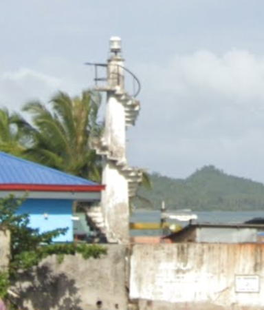
Date unknown. Active; focal plane 13 m (43 ft); continuous red light. 10 m (33 ft) slender white concrete tower with an external stairway winding around the tower. Google's 2023 street view is at right, Randy Establecida has a photo, and the light is a little below center in Elmer Culata's drone view, but the slender tower is hard to see in Google's satellite view. Located on the waterfront of Real, a ferry terminal and fishing port on the west side of the Polillo Strait. Site open, tower closed. PCG-0632; Admiralty F2749.5; NGA 14045.
 

Puerto Real Light, Puerto Real, February 2023
Google Maps street view
 
Malazor Point (Mauban)
Date unknown. Active; focal plane unknown; red flash every 10 s. Concrete tower, height unknown. No photo available but Google has a fuzzy satellite view of the station. Located on a swampy point about 3 km (2 mi) northeast of Mauban. Site status unknown. PCG-0113; Admiralty F2757; NGA 14060.
* Gamau Point (Plaridel)
Date unknown. Active; focal plane about 9 m (30 ft); white flash every 5 s. Approx. 9 m (30 ft) slender square concrete tower with an external concrete stairway winding around the tower. Manol Diaz has a view from the harbor and Google has the 2023 street view at right and a satellite view. Located on the waterfront in Plaridel, a fishing port near the south end of Lopez Bay. Site open, tower closed. Admiralty F2759; NGA 14074.
Silangan Pass (?)
Date unknown. Possibly removed; listed with focal plane 9.5 m (31 ft); two white flashes every 5 s. 9.5 m (31 ft) white concrete tower probably on a platform supported by piles. No photo available and the light is not seen in Google's indistinct satellite view. This light guides (or guided) vessels through the narrow strait separating Alabat Island from the mainland. In 2018 construction began on the Roma Point Bridge, which will connect Alabat Island to the mainland of Luzon. The light may have been removed in connection with this construction. Located off Roma Point. Site open, tower closed. PCG-0120; Admiralty F2760; NGA 14076.

Alabat Island Area Lighthouse
Alabat is a long, narrow island, 33 km (20 mi) long and about 5 km (3 mi) wide, extending along the north side of Lopez Bay.

* [Alabat Pier]
Date unknown. Active (privately maintained); focal plane about 8 m (26 ft); white light, pattern unknown. Approx. 4 m (13 ft) round post, upper half painted white and lower half green. Google has a street view but the light is too small to appear clearly in Google's satellite view. Site open, tower closed. Admiralty F2753.
Alabat
Date unknown. Active; focal plane 11 m (36 ft); red flash every 5 s. 9 m (30 ft) white concrete tower. A very distant street view from the pier is available and F. Alpay has a closeup street view through vegetation and the light is the center of in Google's satellite view. Located on the waterfront, west of the pier, in Alabat, the principal settlement on the south side of the island. Site status unknown. PCG-0119; Admiralty F2754; NGA 14064.

Gamau Point Light, Plaridel, November 2023
Google Maps street view
* Perez
Date unknown. Active; focal plane 10 m (33 ft); red flash every 5 s. 9 m (30 ft) square concrete post with buttressed base. A photo is available but the small light is hard to find in Google's satellite view. Located at the port in Perez, a town near the northwest end of Alabat Island. Site open, tower closed. PCG-0118; Admiralty F2756; NGA 14068.
[Sangirin Point (Tawig)]
Date unknown. Active; focal plane about 10 m (33 ft); white flash every 3 s. Approx. 10 m (33 ft) post on a round pier. No photo available but Google has a satellite view. Located off Sangirin Point about 1.6 km (1 mi) west of Perez, marking the northwest end of Alabat Island. Accessible only by boat. Site open, tower closed. PCG-0578; Admiralty F2756.5; NGA 14070.
Balliscan (Baliskan) Island
Date unknown. Active; focal plane 17 m (56 ft); white flash every 5 s. 9 m (30 ft) slender white concrete tower with a buttressed base. Allan Panganiban has a view from the sea and Google has an indistinct satellite view. Located on a small island off the northwestern end of Alabat Island, marking the entrance to Lopez Bay. Site open, tower closed. PCG-0117; Admiralty F2750; NGA 14056.
Villa Norte
Date unknown. Active; focal plane unknown; flashing white light. Approx. 10 m (33 ft) concrete post rising from a pyramidal base. A photo is at right and the light is centered in Google's satellite view. Located on a bluff on the central north coast of Alabat Island. Site open, tower closed. Admiralty F2755; NGA 14063.

Villa Norte Light, Perez, September 2015
Facebook photo by Town of Perez

Information available on lost lighthouses:

Notable faux lighthouses:

Adjoining pages: North: Southern Taiwan | Southeast: Southeast Luzon | Southwest: Northwest Luzon

Return to the Lighthouse Directory index | Ratings key

Created July 24, 2005. Checked and revised Octiber 21, 2024. Lighthouses: 47. Site copyright 2024 Russ Rowlett and the University of North Carolina at Chapel Hill.