Lighthouses of Central Portugal

Facing the Atlantic Ocean at the southwestern corner of Europe, Portugal (officially the Portuguese Republic, República Portuguesa) has a very distinguished maritime history. Portuguese sailors launched and led the European age of discovery and Portuguese ships have been returning home from the far corners of the globe for about 600 years. It's not surprising that lighthouses have played an important role in Portuguese culture and that they are treasured national monuments today.

This page has information on the lighthouses of the central part of the Portuguese mainland, from Sines through the Leiria District, including the metropolitan area of the capital, Lisbon. There are separate pages for Northern Portugal and Southern Portugal. Lighthouses of the Azores and Madeira (islands discovered and settled by the early Portuguese explorers) are also on separate pages.

The Portuguese word for a lighthouse is farol, plural faróis; a small lightbeacon is often called a farolim. In Portuguese ilha is an island, ilhéu is an islet, cabo is a cape, ponta is a promontory or point of land, rocha is a rock, recife is a reef, baía is a bay, estreito is a strait, rio is a river, and porto is a port or harbor.

Formerly owned by the Navy, the lighthouses in Portugal are now operated by the Lighthouse Directorate (Direção de Faróis), an agency of the National Maritime Authority (Autoridade Marítima Nacional).

ARLHS numbers are from the ARLHS World List of Lights. PT numbers are from the Portuguese Navy list, as recorded by the Portuguese Wikipedia. Admiralty numbers are from volume D of the Admiralty List of Lights & Fog Signals. U.S. NGA List numbers are from Publication 113.

General Sources
Faroís
Lighthouse information from the Direção de Faróis.
Online List of Lights - Portugal
Photos by various photographers posted by Alexander Trabas. Many of the photos for this area are by Eckhard Meyer.
Lighthouses in Portugal
Excellent aerial photos posted by Marinas.com.
Faróis de Portugal
Portuguese Wikipedia article on the country's lighthouses. Near the bottom of the page are links to pages for the individual lighthouses. The photos are also available in Wikimedia's Lighthouses in Portugal category.
World of Lighthouses - Portugal
Photos by various photographers available from Lightphotos.net.
Faróis de Portugal
Fine recent photos posted on Flickr.com by Carlos Olmo Bosco.
Phares d'Europe
Photos posted by Alain Guyomard and Robert Carceller.
Lighthouses of Portugal
Historic postcard images collected by Michel Forand.
Leuchttürme Portugals auf historischen Postkarten
Historic postcard images collected by Klaus Huelse.
GPSNauticalCharts
Navigational chart for Portugal.
Navionics Charts
Navigational chart for Portugal.


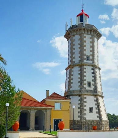
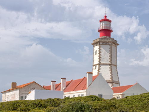
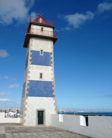
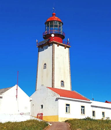
Farol da Guia, Cascais, December 2013
Wikimedia Creative Commons photo
by Vitor Oliveira

Setúbal District Lighthouses

Sines Lighthouses
Sines is a town of about 20,000 residents; it is the site of an important oil terminal and storage facility.
Sines West Mole
Date unknown. Active; focal plane 21 m (69 ft); white flash every 3 s. 8 m (26 ft) round concrete tower painted with red and white horizontal bands. Trabas has José da Palma's photo and Google has a satellite view. Located at the end of the main breakwater of Sines. Site and tower closed. ARLHS POR-099; Admiralty D2160.16; NGA 3583.
** Cabo de Sines
1880. Active; focal plane 56 m (184 ft); two white flashes every 15 s. 22 m (72 ft) round two-stage masonry tower with lantern and two galleries, rising from the front center of a 2-story keeper's complex. Building painted white; lantern and galleries painted red. A photo is at right, Trabas has Meyer's photo, Carlos Olmo also has a good photo, Rui Vale de Sousa has a 2022 photo, Marinas.com has aerial photos, Google has a distant street view, and Google has a satellite view. The upper stage of the light tower was added in 1980; the lantern, which has a modern design, was probably installed at that time also. Huelse has a postcard view of the lighthouse without the extension and with the original lantern. The lighthouse is now nearly surrounded by a large petroleum tank farm. Cabo de Sines is a very prominent headland roughly 120 km (75 mi) south of Setúbal. Located on the point of the cape, about 1.5 km (1 mi) west of the town of Sines. Site open, lighthouse open on Wednesday afternoons. . ARLHS POR-008; PT-401; Admiralty D2160; NGA 3572.

Setúbal Lighthouses
Setúbal is a industrial port known for shipbuilding and ship repair; the city has a population of about 120,000.

*
Doca Pesca (Range Front) (2)
Date unknown. Active; focal plane 14 m (46 ft)); yellow light, 3 s on, 3 s off. 8.5 m (28 ft) round barbell-shaped fiberglass tower, colored with red and white horizontal bands. Trabas has José da Palma's photo, a 2021 photo is available, and Google has a satellite view and a distant street view. This is the entrance range for the Rio Sado estuary, the harbor of Setúbal. The present light replaced a skeletal mast. Located on the breakwater of the fishing harbor of Setúbal. Accessible by walking the pier. Site open, tower closed. PT-384; Admiralty D2151; NGA 3564.
* Azeda (Doca Pesca Range Rear)
Date unknown (modern). Active; focal plane 61 m (200 ft); yellow light, 3 s on, 3 s off. 31 m (102 ft) round cylindrical tower with lantern. The tower is white with two horizontal red bands near the top; lantern also painted red. Trabas has a photo, a 2021 photo is available, Márcio Santos has a 2022 closeup, Gabriela Bruno has a closeup photo of the lantern, and Google has a street view and a satellite view. Located on a hilltop north of the Rua Nova Sintra near the Rua Carlos Daniel in Setúbal, about 2.8 km (1.75 mi) northeast of the front light. Site open, tower closed. . ARLHS POR-065; PT-385; Admiralty D2151.1; NGA 3568.

Cabo de Sines Light, Sines, March 2009
Wikimedia Creative Commons photo by anjopinto
* Canal de Saple Range Front
Date unknown. Active; focal plane 15 m (49 ft); red light, 3 s on, 1 s off. Light mounted atop a 2-story restaurant building. Trabas has Eckhard Meyer's photo and Google has a street view and a satellite view. This is an outbound range guiding vessels leaving the Rio Sado estuary. Located just off the Setúbal waterfront about three blocks east of the Doca Pesca fishing harbor. Site open, tower closed. Admiralty D2152; NGA 3548.
* Anunciada (Canal de Saple Range Rear)
Date unknown. Active; focal plane 24 m (79 ft); red light, 3 s on, 1 s off. Light mounted on the bell tower of a church, the Igreja de Nossa Senhora da Anunciada. Trabas has Meyer's photo and Google has a street view and a satellite view. Located on the Rua Mártires da Pátria, 538 m (1.3 mi) west northwest of the front light. Site open, tower closed. Admiralty D2152.1; NGA 3552.
* Albarquel
Date unknown. Active; focal plane 18 m (59 ft); red light, 1 s on, 1 s off. Mast atop the Forte de Albarquel. Fernando Nunes has a 2021 photo and Google has a satellite view. Located on a low point on the west side of Setúbal harbor. Site open, tower closed. Admiralty D2150.4; NGA 3560.
* Outão (2)
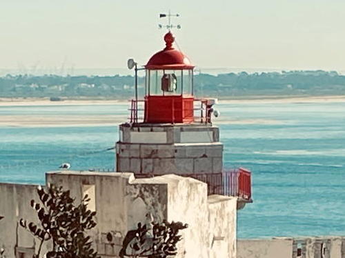
1880 (station established 1775). Active; focal plane 34 m (112 ft); red light, 4 s on, 2 s off. 11 m (36 ft) hexagonal concrete tower with lantern and double gallery. Building is unpainted white concrete with red trim; lantern painted red. This unusual lighthouse is perched atop an old fortress, the Forte de Santiago do Outão, that has been converted into a modern orthopedic hospital. Trabas has a photo, Gabriela Bruno has another fine photo, Wikimedia has two photos (one is seen at right), Fernando Nunes has a view from the sea, and Google has a street view and a satellite view. Behind the building are the steep, forested hills of the Parque Natural da Serra da Arrábida. The lighthouse marks the west side of the entrance to the Rio Sado estuary and the harbor of Setúbal. Located on the coastal road about 9 km (5.5 mi) west of Setúbal. Site open, tower closed. Site manager: Hospital Ortopedico Sant'Iago do Outão. . ARLHS POR-033; Admiralty D2150; NGA 3556.

Outão Light, Setúbal, April 2008
Wikimedia Creative Commons photo by Igiul

Sesimbra Lighthouses
Sesimbra is a fishing port with a population of about 50,000 located west of Setúbal in the lee of Cabo Espichel.
* [Sesimbra Entrance Range Front]
Date unknown. Active; focal plane 10 m (33 ft); red light, 2 s on, 3 s off. A small lantern mounted at the southwest corner of a fort now concerted to a seaside restaurant. Trabas has José da Palma's closeup photo, João Dias has street view and Google has a satellite view. The rear light is mounted on the wall of the same fort 34 m (112 ft) north of the front light. Located on the beachfront east of Sesimbra harbor. Site open, tower closed. Admiralty D2142; NGA 3520.
* Sesimbra Pierhead
Date unknown. Active; focal plane about 11 m (36 ft); red flash every 3 s. 7 m (23 ft) round bluntly conical concrete tower with gallery but no lantern. Lighthouse painted with red and white horizontal bands. Trabas has Meyer's photo, Jose Serrano has a 2021 photo, Mauro Honrado has a closeup street view, and Google has a satellite view. Located at the end of the mole in Sesimbra. Site open, tower closed. ARLHS POR-098; Admiralty D2144; NGA 3516.
* Forte do Cavalo (Sesimbra)
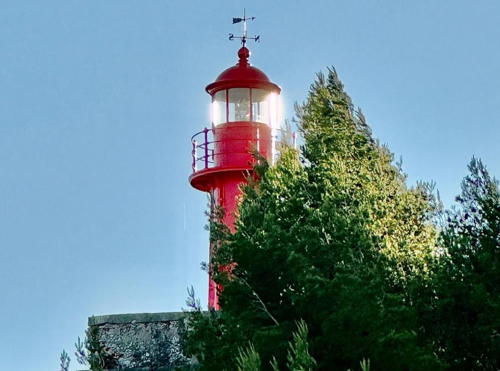
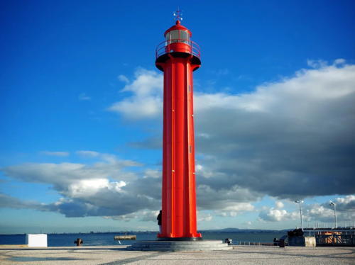
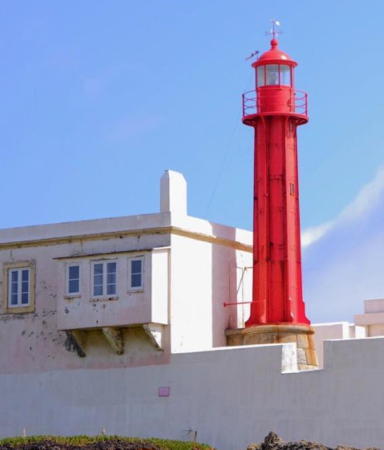
1896. Active; focal plane 35 m (115 ft); white light, 3 s on, 2 s off. 7 m (23 ft) round cylindrical cast iron tower with lantern and gallery, painted bright red. 5th order Fresnel lens in use. Filipe Rocha's photo is at right, Trabas has a closeup photo, José Paiva Wolff has a 2014 photo, and Google has a street view and a satellite view. This is a typical French prefabricated tourelle. The lighthouse is built within the walls of the 17th century Forte de São Teodósio da Ponta do Cavalo. A keeper's house inside the fort is occupied by a resident caretaker. Located on the Ponta do Cavalo, at the western entrance to the harbor of Sesimbra. Site open, tower closed. . ARLHS POR-021; PT-363; Admiralty D2140; NGA 3512.
Farol do Cavalo
Forte do Cavalo Light, Sesimbra, 2006
Wikimedia public domain photo by Filipe Rocha
** Cabo Espichel
1790. Active; focal plane 168 m (551 ft); white flash every 4 s. 31 m (102 ft) tapered hexagonal stone tower with lantern and gallery, rising from a large 1-story keeper's complex. 4th order Fresnel lens in use. The lighthouse is covered with white tiles except for unpainted stone trim; lantern roof painted red. Fog horn (one 8 s blast every 31 s). Otávio Nogueira's photo is at right, Trabas has an excellent photo, Finwe Palantir has a good 2006 photo, Huelse has a historic postcard view, and Google has a street view and a satellite view. Cabo Espichel is a very prominent cape about 27 km (17 mi) south of the Tagus. Monks of the monastery of Nossa Senhora do Cabo (Our Lady of the Cape) are said to have displayed navigational lights here as early as the 15th century. Serving as a landfall light for Lisbon, the lighthouse was long considered one of the more important in the country. The site is rather isolated; the lighthouse was not electrified until 1989 and it is still staffed by rotating crews of three keepers. Located atop a spectacular vertical cliff about 11 km (7 mi) west of Sesimbra. Site open; lighthouse open on Wednesday afternoons. . ARLHS POR-009; PT-360; Admiralty D2139; NGA 3508.

Almada Lighthouses
Almada is the municipality on the south side of the Rio Tejo (Tagus) estuary opposite Lisbon.

*
Chibata
Date unknown (1980s?). Active; focal plane unknown; continuous red light. Approx. 23 m (75 ft) round cylindrical water tower with an expanded upper portion, mounted on a stone base. Upper portion of the tower painted tan, lower portion red. Trabas has Meyer's photo and Google has a street view and a satellite view. Located atop a cliff above the Costa da Caparica about 4 km (2.5 mi) southeast of the mouth of the Rio Tejo. Site open, tower closed. ARLHS POR-087; PT-355; Admiralty D2138.

Cabo Espichel Light, Sesimbra, October 2019
Wikimedia Creative Commons photo by Otávio Nogueira
* Cacilhas
1886. Inactive since 1978 (a low-intensity red decorative light is now displayed). 15 m (49 ft) round cylindrical cast iron tower with lantern and gallery, painted red. Patrick Leroy's photo is at right, Henrique Mota has a 2017 photo, and Samuel Bom also has a 2017 photo. This lighthouse appears to be a prefabricated French tourelle. It was deactivated in May 1978 due to a reconstruction of port facilities in Cacilhas. In 1983 the Navy relocated the lighthouse to Serrata on the island of Terceira in the Azores. Residents of Cacilhas protested this removal for many years and their requests took hold after the lighthouse was deactivated in Terceira in 2004. In 2007 the Navy agreed to return the lighthouse and on 18 July 2009 ceremonies were held celebrating its reinstallation. André Pinho has a good photo of the lighthouse returned to its former home, Filipe Valentim has a 2021 photo, and Google has a street view and a satellite view. The lighthouse was originally painted black, as seen in Huelse's historic postcard view; the current red color has led to some additional controversy in Cacilhas. Located on the waterfront of Cacilhas, on the south side of the Tejo (Tagus). Site open, tower closed. . ARLHS POR-082.
Canal do Alfeite Range Front
Date unknown. Active; focal plane 27 m (89 ft); green (?) light, 2 s on, 1 s off. Light mounted on a tower attached to a building. Trabas has a photo (which appears to show a red, rather than green, light) and Google has a satellite view. This range guides vessels entering the Portuguese Naval Base. The rear light is on a small tower on a hillside behind the base. Located just off the waterfront of the naval base. Site and tower closed. Admiralty D2134.2; NGA 3464.

Alcochete Lighthouse
* Alcochete Pierhead
2006. Active; focal plane 12 m (39 ft); white flash every 5 s. Approx. 7.5 m (25 ft) round cylindrical white concrete tower with gallery and a small lantern. José Paiva Wolff has a photo, Trabas has a photo, and Google has a street view and a satellite view. Located at the end of a long public pier at Alcochete, a municipality east of Almada on the south side of the Rio Tejo. Accessible by walking the pier. Site open, tower closed. . Admiralty D2137.9.

Cacilhas Light, Cacilhas, March 2010
Wikimedia Creative Commons photo by Patrick Leroy

Lisbon Area (Lisboa District) Lighthouses

Lisboa (Lisbon) City Lighthouse
** [Torre de Belém]
1847. Inactive since 1945 at least. 30 m (98 ft) square gothic stone tower rising from within a pentagonal stone fortress. André Pipa has a good photo, Mario Lapid has another photo, and Google has a street view and a satellite view. Completed in 1520, the Torre de Belém was part of the 16th century fortifications protecting Lisbon. In later years it served as a prison and for many other purposes. In 1886 a skeletal lighthouse with lantern and gallery was erected in front of the gothic tower; Huelse has a historic postcard view of this lighthouse. The light tower was removed, apparently in 1945, and the lantern was relocated to Santa Clara on the Ilha do São Miguel in the Azores. The Torre was thoroughly restored during the mid 1990s and is a popular tourist attraction in Lisbon. Located on the north bank of the Tejo (Tagus) in the Belém neighborhood about 3 km (1.8 mi) west of the Ponte 25 de Abril. Site and tower open daily except Mondays. . ARLHS POR-068.

Oeiras Lighthouses
** Mama Sul (Barra do Sul Range Rear)
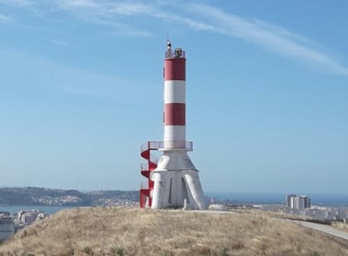
1995 (tower built 1857). Active; focal plane 154 m (505 ft); white light, 3 s on, 3 s off, visible only along the line of the Barra do Sul channel. 15 m (49 ft) white tripod monument. The upper portion of the tower is painted with red and white horizontal bands. An external spiral stairway allows visitors to reach the lower gallery. José & Juliana Maciel's drone view is at right, Trabas has José da Palma's photo, Mauro Honrado has a 2021 closeup, Pedro Reis has a drone view, and Google has a street view and a satellite view. The monument is built atop the Serra de Carnaxide, a rounded hill known informally as Mama Sul ("south breast"). As it happens this conspicuous landmark is aligned with the Barra do Sul channel for ships arriving in Lisbon, and in 1995 a directional light was added to the tower. Because of its great height the light can be seen for 21 nautical miles (39 km or 24 mi). Around 2010 the tower was restored, the daymark and the spiral stairway were added, and the light was moved from the lower gallery to the top of the tower. Located in the Carnaxide neighborhood, about 4 km (2.5 mi) west northwest of Belém. Site open, tower closed. . ARLHS POR-025; Admiralty D2127.15; NGA 3414.
* Esteiro (Barra do Sul Range Middle)
1914. Active; focal plane 82 m (269 ft); red light, 4 s on, 2 s off. 15 m (49 ft) square cylindrical masonry tower with lantern and gallery, rising from a square 1-story base. The tower is unpainted except for two red horizontal bands on the seaward side only; lantern painted red. Carlos Alberto Soares da Silva has a photo, José Dias has a 2019 photo, Trabas has a fine photo, and Google has a satellite view. Located in a city park about 760 m (0.47 mi) northeast of the Gibalta lighthouse. Site open (although the station itself is fenced), tower closed. . ARLHS POR-019; PT-212; Admiralty D2127.1; NGA 3410.

Mama Sul Light, Lisboa, July 2019
Google Maps photo by José & Juliana Maciel
* Gibalta (Barra do Sul Range Front) (2)
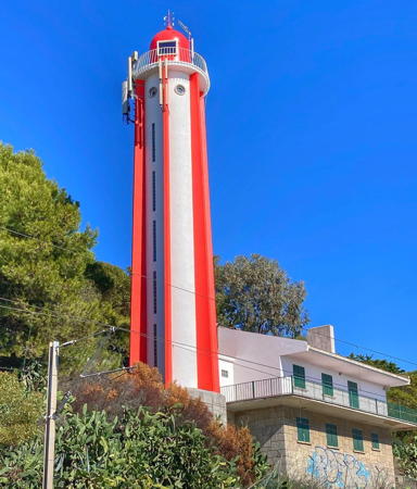
1954 (station established 1914). Active; focal plane 31 m (102 ft); red light, 2 s on, 1 s off. 21 m (69 ft) round cylindrical tower with lantern, gallery, and six vertical ribs. Tower painted white; lantern and ribs painted red: from a distance the lighthouse appears white with narrow vertical red stripes. Nuno Morão's photo is at right, Trabas has an excellent photo, a 2021 photo is available, Ana Simões has a 2022 photo, and Google has a street view and a satellite view. The range guides ships through the passagem entre torres (passage between towers) into the estuary of the Rio Tejo (Tagus) and the harbor of Lisbon. The original lighthouse was destroyed by the great Lisbon earthquake of 31 March 1952. Located on the north bank of the Tejo in Oeiras about 8 km (5 mi) east northeast of the Fortaleza de São Julião da Barra. Site open, tower closed. . ARLHS POR-022; PT-211; Admiralty D2127; NGA 3408.
* Oeiras Marina (Doca de Paco de Arcos) North Pier
Date unknown. Active; focal plane 10 m (33 ft); green flash every 5 s. 6 m (20 ft) round cylindrical concrete tower painted with green and white horizontal bands. Trabas has José da Palmas's closeup photo, Jorge Dias has a 2023 photo, Luís Duarte has a 2021 street view, and Google has a satellite view. Located on the short north pier of the Oeiras Marina, a short distance east of the São Julião da Barra lighthouse. Accessible by walking the pier. Site open, tower closed. Admiralty D2126.55; NGA 3406.2.
* Oeiras Marina (Doca de Paco de Arcos) South Pier
Date unknown. Active; focal plane 10 m (33 ft); red flash every 5 s. 5 m (16 ft) round cylindrical concrete tower painted with red and white horizontal bands. Trabas has José da Palmas's closeup photo and Google has a satellite view and a closeup street view. Located on the south (main) breakwater of the Oeiras Marina, a short distance east of the São Julião da Barra lighthouse. Accessible by walking the pier. Site open, tower closed. Admiralty D2126.5; NGA 3406.
Bugio (2)
1775 (station established at least by 1693). Active; focal plane 28 m (92 ft); green flash every 5 s. 14 m (46 ft) round stone tower with lantern and gallery, rising in the center of a circular 16th century stone fort. 300 mm lens in use; the 3rd order Fresnel lens (1896) was removed in 1994. Lighthouse painted white; lantern painted red. Trabas has Erich Hartmann's photo, Luís Boléo has a 2016 photo, Bruno R. Santos has a 2022 closeup, Huelse has a historic postcard view, and Google has a satellite view. This lighthouse and the Farol de São Julião (next entry) define the entrance to Lisbon, the passagem entre torres (passage between towers) as Portuguese seamen call it. The fort is the Forte de São Lourenço da Cabeça Seca, built on a small island in the center of the entrance to the Rio Tejo (Tagus). Navigational lights were being displayed from the fort in 1693, perhaps much earlier. The early light tower was destroyed by the great earthquake of 1755. The island was transferred from the army to the lighthouse department in 1945 and declared a national historic site. The lighthouse was restored in 1994 and between 1997 and 2001 the fort was restored and protected from storm damage. Located about 2.8 km (1.75 mi) southeast of the Fortaleza de São Julião da Barra. Accessible only by boat or helicopter. Site and tower closed. . ARLHS POR-005; PT-210; Admiralty D2126; NGA 3404.
Farol da Gibalta
Gibalta Light, Oeiras, April 2011
Wikimedia Creative Commons photo by Nuno Morão
São Julião da Barra (2)
1775 (station establishment date unknown). Active; focal plane 39 m (128 ft); red light, 3 s on, 2 s off. 24 m (78 ft) square cylindrical masonry tower with a castellated top and lantern. 4th order Fresnel lens (1895). Tower is unpainted gray masonry; lantern painted white with a red roof. Trabas has a fine closeup, Marinas.com has aerial photos, and Google has a good satellite view and a distant street view. The 16th century Forte de São Julião da Barra guards the entrance to the Rio Tejo (Tagus) and was a key to the defense of Lisbon for centuries. It is not known when navigational lights were first displayed from the fort, but it is known that the light tower had to be repaired following the great earthquake of 1755. The fort now serves as the official residence of the Minister of State and Defense. Located in the center of the fort, just off the Avenida Marginal at the northern entrance to the Rio Tejo in Oeiras. Site and tower closed. . ARLHS POR-053; PT-206; Admiralty D2124; NGA 3400.

Cascais Lighthouses
**** Santa Marta (Range Front)
1868. Active; focal plane 25 m (82 ft); white or red light, depending on direction, 4.5 s on, 1.5 s off. 20 m (66 ft) square masonry tower with lantern and double gallery. Tower colored with blue and white horizontal bands, lantern painted red. Fog horn (one 3 s blast every 10 s). Mike Steele's photo is at right, Trabas has Meyer's closeup, Shaun Surette has a 2022 closeup, Guyomard and Carceller have photos by Eric Valenne, Marinas.com has aerial photos, and Google has a street view and a satellite view. This lighthouse serves general navigation and also serves as the front light of the Barra do Norte Range, the Farol de Guia being the rear light. The lighthouse was increased in height by 8 m (26 ft) in 1936 in order to make it more visible against an increasingly crowded background. Huelse has a postcard view of the lighthouse before it was extended. Adjacent to the lighthouse are the ruins of the 17th century Forte de Santa Marta. In 2000 the lighthouse department agreed to convey the lighthouse to the city of Cascais for development of a historical museum dedicated to both the fort and the lighthouse. Andreas Köhler visited in 2009 and reports that a small museum on Portuguese lighthouses is now open. Located on the south point of land in Cascais, adjacent to a large marina. Site and museum open, tower open to museum visitors. Owner: City of Cascais. Site manager: Santa Marta Lighthouse Museum. . ARLHS POR-052; PT-195; Admiralty D2118; NGA 3388.

Santa Marta Light, Cascais, April 2018
Wikimedia Creative Commons photo by Mike Steele
* Guia (Cascais) (Range Rear) (2)
1761 (station established 1537). Active; focal plane 58 m (190 ft); white light, 1 s on, 1 s off; red light, also 1 s on, 1 s off, is shown along a range line to the east southeast, with the Farol de Santa Marta (next entry) as the front light. 28 m (92 ft) tapered octagonal stone tower with lantern and gallery. 3rd order Fresnel lens (1879). The lighthouse is covered with white tiles except for unpainted stone trim; lantern roof painted red. The keeper's houses are in use as residences for staff of the lighthouse department (Direcção de Faróis). A photo by Vitor Oliveira appears at the top of this page, Trabas has Meyer's photo, Stefan Obcas has a 2022 photo, Lighthouse Digest has a photo by Diogo Monteiro, Guyomard and Carceller have several excellent photos by Johan Buys, Marinas.com has aerial photos, Huelse has a historic postcard view, and Google has a street view and a satellite view. This lighthouse is a beautiful and treasured example of mid 18th century architecture. Monks of the monastery of Nossa Senhora da Guia (Our Lady Guide) began displaying navigational lights on this site in 1537 and the present lighthouse was built after the great earthquake of 1755 largely destroyed the monastery. For arriving ships it serves as a landfall light for Lisbon, and for departing ships it is the rear light of a range that histirically indicated the proper course through the bar of the Tagus. The lighthouse was extensively restored in 2002-03. Located directly on the coastal road (N247) on the west side of Cascais. Site open, tower closed. . ARLHS POR-024; PT-192; Admiralty D2114; NGA 3389.
* Cabo Raso (2)
1915 (station established 1894). Active; focal plane 23 m (75 ft); three white flashes every 15 s. 13 m (43 ft) round cylindrical cast iron tower with lantern and gallery, attached to a 1- and 2-story keeper's complex. Lighthouse painted red. Fog horn (two 4 s blasts every 60 s). This is a typical French prefabricated tourelle. A 2019 photo by Joao Lamares is at right, Guyomard and Carceller have photos, Trabas has a good photo by Egidio Ferrighi, Marinas.com has aerial photos, Huelse has a historic postcard view, and Google has a street view and a satellite view. This lighthouse replaced a wooden tower. The original 5th order lens was replaced by a 6th order lens in 1922 and then by a modern lens in 2003. Cabo Raso marks a right-angle turn in the coastline at the northwestern end of the bight of Lisbon. Located beside the N247 coastal highway on a headland 8 km (5 mi) west of Cascais. Site open, tower closed. . ARLHS POR-011; PT-189; Admiralty D2110; NGA 3380.

Cabo Raso Light, Cascais, June 2019
Wikimedia Creative Commons photo by Joao Lamares

Sintra Lighthouse
** Cabo da Roca
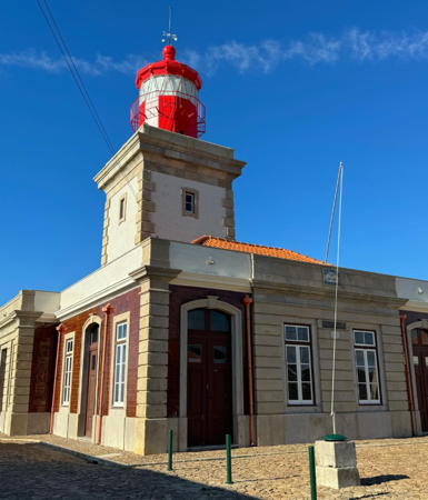
1772. Active; focal plane 165 m (541 ft); four white flashes every 18 s. 22 m (72 ft) square stone tower, rising from a 1-story keeper's complex. 3rd order Fresnel lens in use since 1946. Tower painted white with unpainted stone trim; lantern painted red. Sergei Gussev's photo is at right, José Manuel Fernandes has a lovely winter sunset photo, Lighthouse Digest has a good photo by Paulo Domingos, Trabas has Meyer's closeup photo, Guyomard and Carceller have many fine photos, Marinas.com has aerial photos, Huelse has a historic postcard view, and Google has a street view and a satellite view. This was the first Portuguese lighthouse built "from scratch," although several earlier lights were installed in existing buildings. Spain's Cabo Finisterre (see the Western Galicia page) and Portugal's Cabo de São Vicente (see the Southern Portugal page) may be more famous as western endpoints of Europe, but Cabo da Roca, the "Cape of the Rock," is actually the westernmost point of the Eurasian continent at 9° 29.8' W. The Romans called the cape Promontorium Magnum--the Great Cape. In 1997 the town council of Sintra erected a plaque at the lighthouse that reads in part, "Cabo da Roca: Onde a terra se acaba e o mar começa" (Here ends the land and begins the sea), a line from the famous poet Luís de Camões. Despite this geographical significance, the light here is not as important to navigators as the lights of Cabo Carvoeiro to the north and Cabo Raso to the south. As a result the lighthouse was long neglected; not until 1897 did it have a Fresnel lens, and for the next 50 years it had only a fourth order lens. The station is staffed by a crew of three keepers. It is surrounded by a national park, the Parque Natural de Sintra-Cascais. Located atop a spectacular headland at Azóia, about 12 km (7.5 mi) west of Sintra. Site open, lighthouse open on Wednesday afternoons. Accessible by road, and parking is provided. . ARLHS POR-007; PT-186; Admiralty D2108; NGA 3376.

Mafra Lighthouse
* Ericeira
Date unknown. Active; focal plane 37 m (121 ft); red light, 2 s on, 1 s off. 8 m (26 ft) concrete "sentry box" style lantern attached at an upper corner of a 2-story building. Trabas has Meyer's photo, Google has a street view, and Bing has a satellite view. Located near the waterfront in Ericeira. Site open, tower closed. ARLHS POR-088; Admiralty D2106; NGA 3372.

Torres Vedra Lighthouse
* Assenta
Date unknown. Active; focal plane 80 m (262 ft); white light, 2 s on, 3 s off. 6 m (20 ft) square unpainted white concrete tower. Trabas has Meyer's photo, Beatriz Pereira has a 2021 photo, Francisco Coelho has a street view, and Google has a satellite view. Located atop a steep bluff in São Pedro da Cadeira. Site open, tower closed. Admiralty D2102; NGA 3368.

Cabo da Roca Light, Sintra, December 2016
Flickr Creative Commons photo by Sergei Gussev

Leiria District Lighthouses

Peniche Lighthouses
* Peniche East Mole
Date unknown. Active; focal plane 14 m (46 ft); red flash every 3 s. 10 m (30 ft) round tower, painted with green and white horizontal bands. Trabas has Meyer's photo, Andre Kurokawa has a sea view, and Google has a satellite view. Located at the end of the east mole at Peniche. Accessible by walking the breakwater. Site open, tower closed. ARLHS POR-076; Admiralty D2096; NGA 3352.
* Peniche West Mole
Date unknown. Active; focal plane 12 m (39 ft); red flash every 3 s. 8 m (26 ft) round conical tower with a flared top, painted with red and white horizontal bands. Trabas has an excellent photo, Marco Stoppa has a 2020 photo, Andre Kurokawa has a street view, and Google has a satellite view. Located at the end of the west mole at Peniche. Accessible by walking the breakwater. Site open, tower closed. ARLHS POR-077; Admiralty D2094; NGA 3356.
** Cabo Carvoeiro (2)
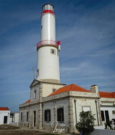
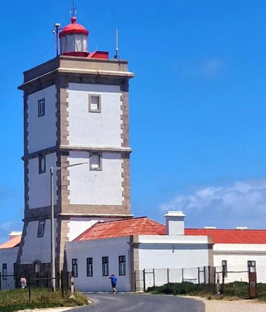
1886 (station established 1790). Active; focal plane 57 m (187 ft); three red flashes every 15 s. 27 m (89 ft) robust square cylindrical stone stone tower with lantern and gallery, rising from the base of a U-shaped 1-story keeper's complex. Buildings painted white with unpainted stone trim; lantern painted red. Fog horn (one 10 s blast every 35 s). A photo is at right, Trabas has a good photo by Meyer, Carlos Olmo Bosco has another excellent closeup photo, Wikimedia has a fine photo by Júlio Reis, Marinas.com has aerial photos, Huelse has a historic postcard view, and Google has a street view and a satellite view. Cabo Carvoeiro is one of the most prominent capes of the Portuguese coast. Lights are said to have been displayed here for centuries on the tower of the chapel of Nossa Senhora de Vitória, now demolished. The original lighthouse, 21 m (69 ft) tall, was identified as inadequate by an 1881 commission. In modern times the lighthouse is no longer considered a major coastal light; the red light displayed guides ships on their approach to the nearby fishing port of Peniche. Located at the end of a promontory about 3 km (1.8 mi) west of the Peniche waterfront. Parking is available. Site open, lighthouse normally open on Wednesday afternoons; during summer 2018 volunteers had it open daily except Mondays in July and August. . ARLHS POR-006; PT-143; Admiralty D2088; NGA 3340.

Cabo Carvoeiro Light, Peniche, August 2010
Flickr Creative Commons photo by Oleg
** Berlenga (Farol Duque de Bragança)
1842. Active; focal plane 121 m (397 ft); white flash every 10 s. 29 m (95 ft) square stone tower with lantern and gallery, attached to a 1-story keeper's complex. Tower painted white with unpainted stone trim; lantern painted red. Fog horn (one 6 s blast every 28 s). A photo is at right, Wikimedia has another good photo, Francisco Carmona has an excellent 2023 photo, Trabas has a photo by José da Palma, Marinas.com has aerial photos, Huelse has a historic postcard view, and Google has a satellite view. Berlenga Grande is the largest of three small islands about 9 km (5.5 mi) west northwest of Cabo Carvoeiro. There is an anchorage on the southeast side of the island, and transportation is available from Peniche. Because the islands lie directly on the coastal shipping lanes, the lighthouse has always been considered one of the most important in Portugal. In 1897 a hyperradiant Fresnel lens (larger than first order) was installed: one of only a few dozen such lenses ever built. The great lens was removed in 1985 when the light was electrified and a modern 400 mm (16 in) lens installed. One of the three panels of the lens is now on display at the Lighthouse Directorate's museum in Paço de Arcos, and another is displayed at the Santa Marta lighthouse near Lisbon. The light was solarized in 2000 without reducing its 43 km (27 mi) range. Located at the highest point of the western side of the island. Site open, lighthouse open on Wednesday afternoons. . ARLHS POR-004; PT-136; Admiralty D2086; NGA 3336.
Farilhão (Farilhãos)
Date unknown. Active; focal plane 100 m (328 ft); two white flashes every 5 s. 6 m (20 ft) tower painted with red and white horizontal bands. No closeup photo available but Trabas has Meyer's very distant view from the sea, Nuno Fernandes also has a very distant view, and Bing has an indistinct satellite view of the station. The Farilhãos are a group of small rocky islands about 8 km (5 mi) north northwest of the Berlenga lighthouse. Located atop Ilhéu Farilhão Grande, the largest of the islands. Practically inaccessible. Site and tower closed. ARLHS POR-061; PT-132; Admiralty D2084; NGA 3332.

Berlenga Light, Peniche, August 2009
Wikimedia Creative Commons photo by F nando

Alcobaça Lighthouse
* São Martinho do Porto Range Rear
Date unknown. Active; focal plane 12 m (39 ft); red light occulting once every 6 s. 12 m (39 ft) post mounted atop a square 2-story concrete equipment shelter; there is a gallery atop the building. Trabas has a photo, and Google has a street view and a satellite view. The front light is a similar post with no equipment shelter. Located about 150 m (500 ft) southeast of the waterfront of São Martinho do Porto. Site open, tower closed. ARLHS POR-097; Admiralty D2078.1; NGA 3328.

Nazaré Lighthouses
* Nazaré North Mole (2)
Around 2014. Active; focal plane about 12 m (39 ft); red light, pattern unknown. 6 m (20 ft) round concrete tower painted with red and white horizontal bands. Paul Rosenhart has a photo, another photo is available, Trabas has Meyer's closeup, Oleg Rumiantsev has a street view, and Google has a satellite view. Located on the short north breakwater of Nazaré harbor. Site open, tower closed. Admiralty D2074.3.
** Nazaré (Forte de São Miguel)
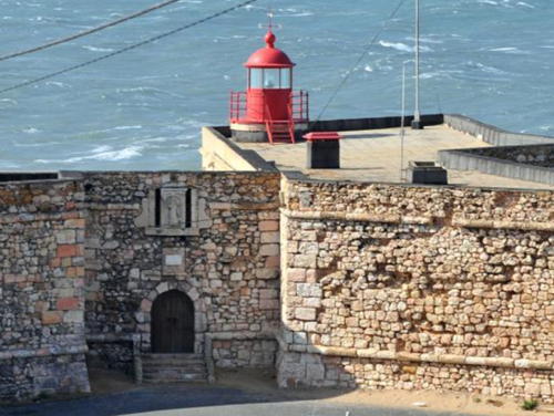
1903. Active; focal plane 50 m (164 ft); white light, 2 s on, 1 s off. 8 m (26 ft) round cast iron (?) lantern mounted on the wall of the fort. Lantern painted bright red. Fog siren (one 10 s blast every 35 s). Jean-Michel Brunet's photo is at right, Trabas has a good photo, Carlos Olmo Bosco has a closeup of the lantern, Piotr Zawiła has a 2022 photo, and Google has a street view and a satellite view. This light is built on the stone walls of the Forte de São Miguel, which dates from 1577. This location is famous among surfers for its extremely high waves; spectators gather around the lighthouse to watch and the lighthouse is often seen in TV coverage. Located on a very sharp headland at the west end of the town of Nazaré, a village now popular as a beach resort. Site open, fort open. . ARLHS POR-032; Admiralty D2074; NGA 3316.

Forte de São Miguel Light, Nazaré, June 2014
Wikimedia Creative Commons photo by Jean-Michel Brunet

Marinha Grande Lighthouse
** Penedo da Saudade
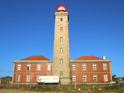
1912. Active; focal plane 55 m (180 ft); two white flashes every 15 s. 32 m (105 ft) square masonry tower with lantern and gallery, attached to a 2-story brick keeper's complex. 3rd order Fresnel lens. A photo is at right, Trabas has Meyer's closeup photo, Jose Carlos Gago has a 2021 photo, Noemia Costa Dias has a nice closeup, Marinas.com has aerial photos, Huelse has a historic postcard view, Google has a good street view, and Google has a satellite view. This lighthouse does not mark a prominent cape; it was located at a convenient point halfway between the lights of Cabo Mondego and Ilha Berlenga. The original 3rd order lens was transferred to Cabo Mondego in 1921, but it was replaced by another 3rd order lens of a different type. The lighthouse and keeper's house were both renovated and restored in 1997-98. A penedo is a boulder, in this case a huge rock in the sea in front of the lighthouse. Located directly on the coastal road about 800 m (1/2 mi) north of São Pedro de Moel. Streetside parking is available. Site open, lighthouse open on Wednesday afternoons. . ARLHS POR-034; PT-117; Admiralty D2072; NGA 3312.

Information available on lost lighthouses:

Notable faux lighthouses:

  • Belém (Doca de Bom Sucesso) (1940), a 20 m (66 ft) cylindrical concrete tower with an open lantern and gallery near the Torre de Belém on the Lisbon waterfront. This tower is floodlit at night but it has never been an official aid to navigation. A 2019 closeup photo is available and Google has a street view and a satellite view. Navionics charts the tower with a red light, but no lens is seen in closeup photos.
  • Clube Náutico dos Oficiais e Cadetes da Armada, the Portuguese Navy's officers' club in Almada, has a faux lighthouse attached to the club building. Antonio Baio Dias has a photo and Google has a satellite view.
  • Estação Fluvial Belém, at the passenger ferry terminal on the Lisbon waterfront. The tower does not appear to have a light. Margarita Sharapova has a photo, and Google has a street view and a satellite view

Panedo da Saudade Light, São Pedro de Moel, August 2013
Wikimedia Creative Commons photo by Romain.D.C

Adjoining pages: North: Northern Portugal | South: Southern Portugal

Return to the Lighthouse Directory index | Ratings key

Posted December 17, 2005. Checked and revised June 25, 2023. Lighthouses: 37. Site copyright 2023 Russ Rowlett and the University of North Carolina at Chapel Hill.