Lighthouses of Russia: Northern White Sea

Russia (Россия, Rossiya in Russian) is by far the world's largest country, spanning a little over 150° in longitude. It is organized as the Russian Federation (Rossiyskaya Federatsiya) with members known as federal subjects (sub'yekty federatsii). Russia is primarily a continental nation but it has important coastlines on the Baltic, Black, and Caspian Seas and very long coastlines on the Arctic Ocean and North Pacific Ocean. To guard these coasts it operates hundreds of lighthouses, many of them historic.

The northwestern corner of Russia lies on the Barents Sea, an arm of the Arctic Ocean. The broad, eastward-pointing Kola Peninsula (Kolskiy Poluostrov) separates the Barents Sea from the nearly-enclosed White Sea, which extends southward more than 500 km (300 mi). Arkhangel'sk, located at the southeasternmost point of the White Sea, became Russia's chief port under Ivan the Terrible in the mid 1500s and there has been a lively trade between Western Europe and Arkhangel'sk through these northern waters for almost 500 years.

This page lists includes lighthouses on the northwestern coasts of the White Sea in the Tersky and Kandalakshsky Districts of Murmansk Oblast.

The Russian word for a lighthouse is mayak (маяк); ostrov is an island, mys is a cape, bukhta or guba is a bay, zaliv is a larger bay or gulf, proliv is a strait, reka is a river, and gavan' is a harbor.

Russian lighthouses are owned by the Russian Navy and maintained by the Navy's Office of Navigation and Oceanography (Управление навигации и океанографии).

ARLHS numbers are from the ARLHS World List of Lights. Russian light list (RU) numbers are from Russian Navy Publication 2105, as reported by the Admiralty. Admiralty numbers are from volume L of the Admiralty List of Lights & Fog Signals. U.S. NGA numbers are from Publication 115. The Russian light list, Огни и знаки (Lights and Signs), is not available online.

General Sources
Online List of Lights - Russia - White Sea
Photos by various photographers posted by Alexander Trabas.
World of Lighthouses - Arctic Coast of Russia
Photos by various photographers available from Lightphotos.net.
White Sea Lighthouses in Russia
Photos by various photographers available from Wikimedia.com.
Russische Leuchttürme auf historischen Postkarten
Historic postcard images posted by Klaus Huelse.
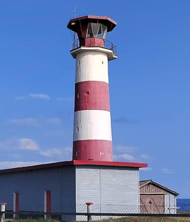
Kashkarantsy Light, Kashkarantsy, August 2024
Google Maps photo by Irina Blokhina

Tersky District Lighthouses

The Tersky District includes the entire north shore of the White Sea. It is nearly deserted, with a little over 6000 permanent residents.

Kola Peninsula South Coast Lighthouses
Pulon'ga
Date unknown. Active; focal plane 37 m (121 ft); white flash every 7 s. 13 m (43 ft) square pyramidal skeletal tower, covered by a slatted daymark painted white with a red horizontal bands. Lightphotos.net has Alexey Vukolov's closeup photo and distant view but Google has only a distant satellite view of the area. This light marks the narrowest passage of the White Sea Throat, the strait connecting the White Sea to the Barents Sea. Located on a headland about 3 km (2 mi) east of the mouth of the Pulon'ga River on the southeast coast of the Kola Peninsula. Site status unknown. ARLHS ERU-269; Admiralty L6590; RU 2105-3410; NGA 15532.
Mys Nikodimskiy
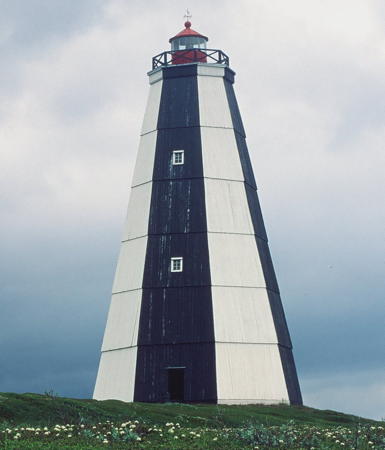
Date unknown. Active; focal plane 52 m (171 ft); two white flashes every 15 s. 27 m (89 ft) octagonal pyramidal tower, covered with wood siding, with lantern and gallery. Lighthouse painted with black and white vertical stripes; lantern painted red. Fog horn (three blasts every 30 s). The EDM Company restored the lighthouse in 2006. Lightphotos.net has the closeup photo seen at right and a 2005 photo is available, but Google has only a very distant satellite view of the cape. This light marks the west side of the southern entrance to the White Sea Throat. Located on a headland on the south side of the Kola Peninsula about 40 km (25 mi) east of Tetrino. Site status unknown. ARLHS ERU-262; Admiralty L6596; RU 2105-3435; NGA 15544.
Kashkarantsy
Date unknown. Active; focal plane 26 m (85 ft); two white flashes every 15 s. 24 m (79 ft) concrete tower with lantern and a small gallery, painted with red and white horizontal bands. Irina Blokhina's 2024 photo is at the top of this page, Vitaly Telegin's 2015 photo shows the lighthouse freshly painted in September 2015, Wikimedia has several photos, Lightphotos.net has Oleg Filonok's closeup photo, and Google has a satellite view. This lighthouse marks the north side of the entrance to Kandalaksha Bay. Located on the south side of the Kola Peninsula at Kashkarantsy, about 25 km (15 mi) west of Varzuga. Site status unknown. ARLHS ERU-038; Admiralty L6610; RU 2105-5425; NGA 15576.
Kuzreka (Kuzretskiy, Kuz River)
Date unknown. Active; focal plane 14 m (46 ft); white flash every 3 s. 11 m (36 ft) square pyramidal tower carrying a daymark painted white with a red vertical stripe. No photo available and Google has only a fuzzy satellite view of the location. Kuzreka is a village at the mouth of Kuz River, about 25 km (15 mi) southeast of the district seat of Umba. Location on the west side of the entrance to Kuzreka. Site status unknown. Admiralty L6612; NGA 15588.

Mys Nikodimskiy Light, Kashkarantsy District, ca. 2013
Lightphotos.net photo from Polar Post

Kandalaksha Bay Lighthouses
Kandalaksha Bay, the narrow northwest-pointing arm of the White Sea, leads to the port of Kandalaksha, a historic town settled as early as the 11th century. In recent years the population of Kandalaksha has dwindled to about 35,000.

Mys Turiy
Date unknown. Active; focal plane 35 m (128 ft); white flash every 3 s. 9 m (30 ft) pyramidal tower with black and white diagonal stripes. No photo available and Google has only a fuzzy satellite view of the cape. Located on a prominent headland on the north side of lower Kandalaksha Bay. Site status unknown. Admiralty L6614; RU 2105-5795; NGA 15724.
Ostrov Vol'ostrov
Date unknown. Active; focal plane 67 m (220 ft); white flash every 4 s. 16 m (52 ft) square wood skeletal pyramid partially enclosed with horizontal slats. Wikimapia has two photos and the tower is probably seen in Bing's indistinct satellite view. This light and the next one guides vessels to Umba, the district seat. Located on the highest point of an island about 15 km (9 mi) northwest of Mys Turiy. Site open, tower closed. Admiralty L6616; RU 2105-5800; NGA 15720.
Mys Chukcherskiy
Date unknown. Active; focal plane and light characteristics unknown. This tower appears to be at least 10 m (33 ft) tall. No photo available but the tower is seen in Google's satellite view and Bing's satellite view. Located at the northwestern tip of the broad Turiy Peninsula. Admiralty L6617.
Ostrov Nablyundeniya (2)
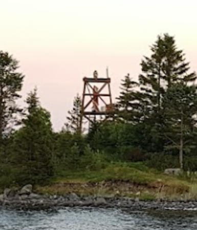
2008. Active; focal plane 13 m (43 ft); continuous yellow light. 7 m (23 ft) square pyramidal tower, painted red. Andrey Vyborny has a view from the sea (also seen at right) and Google has an indistinct satellite view. NGA formerly described this light as a "white house, red roof, and lantern gallery, mast in front." Located on an island marking the entrance to the bay leading to Umba, on the north shore of the estuary. Accessible only by boat. Site status unknown. Admiralty L6618; RU 2105-5817; NGA 15716.
Ostrova Stolbovyye Ludy
Date unknown. Active; focal plane 24 m (79 ft); red flash every 3 s. 9 m (30 ft) pyramidal tower, painted black. No photo available but Bing has a satellite view. Located on a skerry in the entrance to Por'ya Guba, a bay on the north side of Kandalaksha Bay. Accessible only by boat. Site status unknown. Admiralty L6624; RU 2105-5850; NGA 15644.

Ostrov Nablyundeniya Light, Kandalaksha Bay, July 2018
Google Maps photo by Andrey Vyborny
Ostrov Bol'shoy Sedlovatty
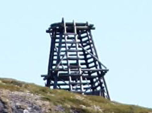
Date unknown. Obviously abandoned but listed with focal plane 27 m (89 ft); white flash every 3 s. 4 m (13 ft) square wood skeletal tower. Dmitry Lisichkin has the photo at right but Google has only a fuzzy satellite view of the island. Located on an island about 6 km (3.5 mi) southeast of Mys Kochinny. Accessible only by boat. Site status unknown. Admiralty L6628; NGA 15640.
 
Mys Kochinnyy
Date unknown. Active; focal plane 19 m (62 ft); white flash every 5 s. 10 m (33 ft) gray tower with a white lantern. No photo available and Google has only a very distant satellite view of the area. Located on a headland on the north side of the estuary about 60 km (37 mi) southeast of Kandalaksha, marking a point where the estuary narrows sharply. Site status unknown. ARLHS ERU-246; Admiralty L6630; RU 2105-5880; NGA 15636.
Ostrova Rezanovy Ludy (2)
2011 (station establishment date unknown). Active; focal plane 25 m (82 ft); white flash every 4 s. 17 m (56 ft) round metal tower, painted white with a brown horizontal band. No photo available and the tower is not seen in Bing's fuzzy satellite view. The earlier light was a 13 m (43 ft) "truncated pyramid," white with a red vertical stripe. Located at the southeast end of an island off the north shore of the bay opposite Lesozavodskiy. Accessible only by boat. Site status unknown. ARLHS ERU-270; Admiralty L6632; RU 2105-5890; NGA 15632.

Ostrov Bol'shoy Sedlovatty Light, Kandalaksha Bay, August 2011
Google Maps photo by Dmitry Lisichkin

Kandalakshsky District Lighthouse

Ostrov Kibirinskiy (Kibirinskiye Ludy) Range Front
Date unknown. Active; focal plane 17 m (56 ft); white flash every 2 s. 13 m (43 ft) yellow wooden tower with a black lantern carrying a white daymark with a red vertical stripe. No photo available but Google has a distant satellite view. Located on an island about 20 km (13 mi) southeast of Kandalaksha. Accessible only by boat. Site status unknown. Admiralty L6636; NGA 15620.
Ostrov Kibirinskiy (Kibirinskiye Ludy) Range Rear
Date unknown. Active; focal plane 32 m (105 ft); flash every 5 s, white or red depending on direction. 17 m (56 ft) yellow wooden tower with a black lantern carrying a white daymark with a red vertical stripe. No photo available but Google has an indistinct satellite view. Located on an island about 20 km (13 mi) southeast of Kandalaksha. Accessible only by boat. Site status unknown. ARLHS ERU-163; Admiralty L6636.1; RU 2105-5911; NGA 15624.
Kamenistyy (Mys Vonyuchiy) Range Front
Date unknown. Active; focal plane 10 m (33 ft); white flash every 2 s. 10 m (33 ft) square pyramidal skeletal tower; the front face is covered by a white daymark with a red vertical stripe. No photo available but Google has a distant satellite view. Located on a point of land on the east side of the bay about 16 km (10 mi) southeast of Kandalaksha. Accessible only by boat. Site status unknown. Admiralty L6642; NGA 15612.
Kamenistyy (Mys Vonyuchiy) Range Rear
Date unknown. Active; focal plane 14 m (46 ft); white flash every 4 s. 13 m (43 ft) square pyramidal skeletal tower; the front face is covered by a white daymark with a red vertical stripe. No photo available and the light is not seen in Google's distant satellite view. Located on the east coast of the bay 240 m (262 yd) north northwest of the front light. Site status unknown. Admiralty L6642.1; NGA 15616.
Krestovyy Range Front
Date unknown. Active; focal plane 23 m (75 ft); quick-flashing white light. 16 m (52 ft) square pyramidal skeletal tower; the front face is covered by a white daymark with a red vertical stripe. No photo available but Google has an indistinct satellite view. Located on Ostrov Bol'shoy Berezovyy, a forested island about 8 km (5 mi) southeast of Kandalaksha. Accessible only by boat. Site status unknown. Admiralty L6643; NGA 15600.
Krestovyy Range Rear
Date unknown. Active; focal plane 64 m (210 ft); white light, 1.5 s on, 1.5 s off. 14 m (46 ft) square pyramidal skeletal tower; the front face is covered by a billboard-size white daymark panel with a red vertical stripe. No photo available but Google has a satellite view. Located on a hillside on the mainland 2.8 km (1.75 mi) northwest of the front light. Site status unknown. ARLHS ERU-045; Admiralty L6643.1; NGA 15604.
Kandalaksha Range Rear
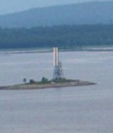
Date unknown. Active; focal plane 35 m (115 ft); red light, 2 s on, 2 s off. 30 m (98 ft) square cylindrical skeletal tower carrying a slatted daymark painted white with a black (?) vertical stripe. Lightphotos.net has Konstantin Sushko's distant view from the sea (a small portion is seen at right) and Google has a satellite view. The front light is on a similar but shorter tower. Located on an island about 3 km (2 mi) off the Kandalaksha waterfront. Accessible only by boat. Site status unknown. Admiralty L6645.1.
Ostrov Gorelyy
Date unknown. Active; focal plane 11 m (36 ft); white flash every 3 s. 7 m (23 ft) white square pyramidal tower. No photo available but Bing has a satellite view. Located on an island about 13 km (8 mi) southest of Kandalaksha. Accessible only by boat. Site status unknown. Admiralty L6646; NGA 15608.
 

Kandalaksha Range Rear Light, Kandalaksha Bay, ca. 2012
Lightphotos.net (ex-Panoramio) photo by Konstantin Sushko
 
Ostrov Sedlovatyy
Date unknown. Active; focal plane 24 m (79 ft); white flash every 5 s. 22 m (72 ft) square cylindrical skeletal tower covered with a slatted daymark painted white. Lightphotos.net has Dimitry Lobusov's very distant view from the sea and Bing has a satellite view. Located on an island on the south side of Kandalaksha Bay about 25 km (15 mi) south of Kandalaksha. Accessible only by boat. Site status unknown. Admiralty L6652.
Ostrov Drestnoy Baklysh
Date unknown. Active; focal plane 14 m (46 ft); white flash every 3 s. 12 m (39 ft) square cylindrical skeletal tower covered with a slatted daymark painted with red and white horizontal bands. Lightphotos.net has Dimitry Lobusov's view from the sea and Google has an indistinct satellite view. Located on a skerry on the south side of Kandalaksha Bay. Accessible only by boat. Site status unknown. ARLHS ERU-239; Admiralty L6666; RU 2105-5715; NGA 15628.
Ostrov Priglubnyy Baklysh
Date unknown. Active; focal plane 18 m (59 ft); flash every 3 s, white, red or green depending on direction. 12 m (39 ft) pyramidal wood tower carrying a daymark painted with black and white horizontal bands. No photo available but Google has a satellite view. NGA confuses this light with Ostrov Drestnoy Baklysh, listing both with the latter name. Located on a small island in the mouth of Kovda Bay, which leads to the town of Lesozavodsky. Accessible only by boat. Site status unknown. ARLHS ERU-266; Admiralty L6672; NGA 15648.
Ostrov Sredniye Ludy
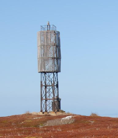
Date unknown. Active; focal plane 32 m (105 ft); two white flashes every 5 s. 17 m (56 ft) square cylindrical skeletal tower. The upper half of the tower is surrounded by a round vertically slatted daymark. The daymark is supposed to be painted white with a red horizontal band, but in Serge Gorbartov's 2006 photo at right all the paint has worn off the wood. Note the lantern sitting behind the tower. Wikimapia also has a photo but the lighthouse is not shown in Google's satellite view. Located on an island in the middle of the lower end of Kandalaksha Bay. Accessible only by boat. Accessible only by boat. Site status unknown. Admiralty L6682; RU 2105-5600; NGA 15692.
Mys Titov
Date unknown. Active; focal plane and light characteristic unknown. No description available but Google's satellite view reveals a tower, probably concrete, probably at least 10 m (33 ft) tall. Located on a sharp cape on the south side of Kandalaksha Bay. Site status unknown. Admiralty L6676.
 

Ostrov Sredniye Ludy Light, Kandalaksha Bay, May 2006
ex-Panoramio photo by Serge Gorbartov

Information available on lost lighthouses:

Adjoining pages: North: Northern Kola Peninsula | South: Karelia

Return to the Lighthouse Directory index | Ratings key

Posted December 7, 2005. Checked and revised May 15, 2025. Lighthouses: 25. Site copyright 2025 Russ Rowlett and the University of North Carolina at Chapel Hill.