Lighthouses of Russia: Taymyria

Russia (Россия, Rossiya in Russian) is by far the world's largest country, spanning a little over 150° in longitude. It is organized as the Russian Federation (Rossiyskaya Federatsiya) with members known as federal subjects (sub'yekty federatsii). Russia is primarily a continental nation but it has important coastlines on the Baltic, Black, and Caspian Seas and very long coastlines on the Arctic Ocean and North Pacific Ocean. To guard these coasts it operates hundreds of lighthouses, many of them historic.

Russia's Northern Sea Route (Sevmorput) is a well developed sea lane extending through the Arctic Ocean to connect the Atlantic and Pacific. The route extends from Murmansk at the northwestern corner of Russia past the island of Novaya Zemlya and parallel to the Siberian coast all the way to the Bering Strait.

Taymyria is the region of the Arctic including the Taymyr Peninsula, the northernmost extension of Eurasia. The region borders two basins of the Arctic Ocean, the Kara Sea to the northwest and the Laptev Sea to the northeast. Administratively it is a part of the Taymyrsky Dolgano-Nenetsky District of Krasnoyarsk Krai. The district has fewer than 35,000 permanent residents, most of whom live in the town of Dudinka on the lower Yenisey River.

This page includes lighthouses of the Taymyr peninsula area; there is a separate page for the lighthouses of the Yenisey Gulf.

The Russian word for a lighthouse is mayak (маяк); ostrov is an island, poluostrov is a peninsula, mys is a cape, bukhta or guba is a bay, zaliv is a larger bay or gulf, proliv is a strait, reka is a river, and gavan' is a harbor.

Russian lighthouses are owned by the Russian Navy and maintained by the Navy's Office of Navigation and Oceanography (Управление навигации и океанографии).

ARLHS numbers are from the ARLHS World List of Lights. Admiralty numbers are from volume L of the Admiralty List of Lights & Fog Signals. U.S. NGA numbers are from Publication 115.
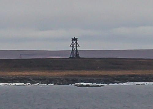
Ostrov Vardropper Light
Ostrov Vardropper Light, Plavnikov Islands, April 2011
ex-Panoramio photo copyright Geiden; used by permission
General Sources
World of Lighthouses - Arctic Coast of Russia
Photos available from Lightphotos.net.
Online List of Lights - Russia - Arctic Sea Coast
Photos by various photographers posted by Alexander Trabas.
Pyasina Gulf Lighthouses
Ostrov Zapadnyy Kamennyy (West Stone Island)
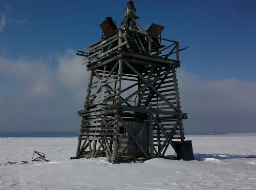
Date unknown. Active; focal plane and light characteristic unknown. 8 m (26 ft) square wood skeletal tower. A photo is at right but Google has only a very distant satellite view of the area. The light marks the western end of the Kamennyy (Stone) Islands, about 160 km (100 mi) northeast of Dikson, the town at the mouth of the Yenisey River. Accessible only by boat. Site status unknown. Admiralty L9337; NGA 17278.
Mys Polovinka
Date unknown. Active; focal plane 27 m (89 ft); white flash every 5 s. 12 m (39 ft) square pyramidal wood skeletal tower. No photo available and Google has only a very distant satellite view of the area. Located on a headland at the southern entrance to the Pyasina River delta. Site status unknown. NGA 17272.
Ostrov Otmelyy
Date unknown. Active; focal plane 14 m (46 ft); white flash every 5 s. 13 m (43 ft) square pyramidal wood skeletal tower. No photo available and Google has only a very distant satellite view of the area. Located on an island in the entrance to the Pyasina River delta. Accessible only by boat. Site status unknown. NGA 17276.

Ostrov Zapadnyy Kamennyy Light, Kamennyy Islands, April 2011
ex-Panoramio photo copyright Geiden; used by permission
Plavnikov Islands Lighthouses
The Plavnikov Islands are a complex archipelago lying between the Pyasina Gulf and the Kolosovykh Peninsula on the west side of the Taymyr Peninsula.
Ostrov Baranov
Date unknown. Active; focal plane 31 m (102 ft); white flash every 10 s. 11 m (36 ft) square pyramidal wood skeletal tower. No photo available and Google has only a very distant satellite view of the island. Located on a small island marking the western end of the Plavnikov Islands. Accessible only by boat. Site status unknown. Admiralty L9340; NGA 17280.
Ostrov Vardropper
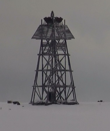
Date unknown. Active; focal plane 28 m (92 ft); white flash every 8 s. Approx. 15 m (49 ft) square pyramidal wood skeletal tower. Geiden's photo is at the top of this page but Google has only a very distant satellite view of the island. Located on a small, isolated island about 22.5 km (14 mi) north of Ostrov Baranov. Accessible only by boat. Site status unknown. Admiralty L9342; NGA 17284.
Ostrov Oleniy
Date unknown. Active; focal plane 68 m (223 ft); white flash every 5 s. 14 m (46 ft) square pyramidal wood skeletal tower. No photo available and Google has only a very distant satellite view of the area. Located near the west end of one of the larger islands of the Plavnikov group. Accessible only by boat. Site status unknown. Admiralty L9343; NGA 17292.
Ostrov Diabazovyy (Mys Nordenshel'da)
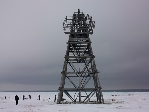
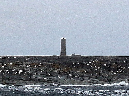
Date unknown. Active; focal plane 20 m (66 ft); white flash every 10 s. 15 m (49 ft) square pyramidal wood skeletal tower. Geiden's photo is at right but Google has only a very distant satellite view of the island. Located on a small island at the northwestern end of the Plavnikov group. Accessible only by boat. Site status unknown. Admiralty L9344; NGA 17296.
Ostrov Popova-Chukchina (Popovachukina)
Date unknown. Active; focal plane 27 m (89 ft); white flash every 7 s. 12 m (39 ft) square pyramidal wood skeletal tower. No photo available and Google has only a very distant satellite view of the area. Located on a large island at the north end of the Plavnikov group. Accessible only by boat. Site status unknown. Admiralty L9345; NGA 17300.
Ostrov Diabazovyy Light
Ostrov Diabazovyy Light, Plavnikov Islands, April 2011
ex-Panoramio photo copyright Geiden; used by permission
Central Kara Sea Lighthouse
Ostrov Uyedineniya (Uedineniya)
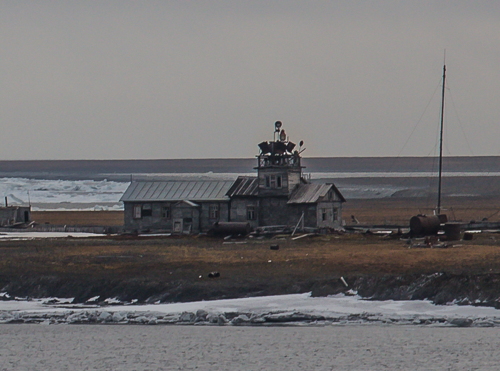
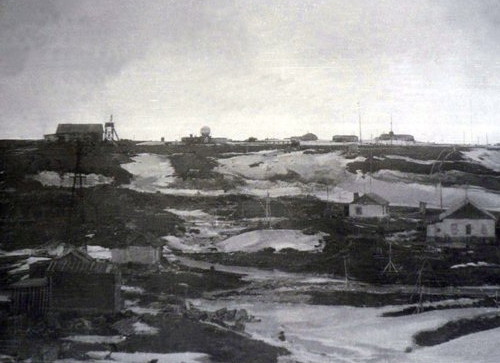
Date unknown. Presumably inactive. Approx. 8 m (26 ft) square wood skeletal tower next to a 1-story wood building. The light tower is in the left background, at the right end of a building, in the 1985 view at right, but the station is not seen in Google's indistinct satellite view of the island. Uyedineniya Island (Solitude Island) is an isolated island in the central Kara Sea, about 330 km (200 mi) north of the Plavnikov Islands. A polar observatory on the island was abandoned in 1996. The lighthouse is presumably located at the observatory. Accessible only by boat. Site status unknown. ARLHS ASR-083.

Western Taymyr Peninsula Lighthouses
Mikhaylova Severnyy
Date unknown. Active; focal plane 35 m (115 ft); white flash every 9 s. 13 m (43 ft) square pyramidal wood skeletal tower. No photo available and Google has only a very distant satellite view of the area. Located at the northwestern end of the Mikhaylova Peninsula, which projects about 50 km (30 mi) into the Kara Sea north of the Plavikov Islands. Site status unknown. Admiralty L9348; NGA 17304.
Mys Sterlegova
Date unknown. Active; focal plane 34 m (112 ft); white flash every 6 s. 12 m (39 ft) square pyramidal wood skeletal tower. A closeup photo is available but Google has only a very distant satellite view of the area. Located on a promontory about 65 km (40 mi) northeast of the Mikhaylova Peninsula. Site status unknown. Admiralty L9349.5; NGA 17336.
Ostrov Uyedineniya Light
Ostrov Uyedineniya Station, Kara Sea, 1985
photo from Soviet polar program archives
Ostrov Ringnes
Date unknown. Active; focal plane 45 m (148 ft); white light, 2 s on, 6 s off. 12 m (39 ft) square pyramidal wood skeletal tower. No photo available and Google has only a very distant satellite view of the island. Located on a small island, the westernmost island of the Mona group, about 40 km (25 mi) off the coast of the Taymyr Peninsula. Accessible only by boat. Site status unknown. Admiralty L9450; NGA 17324.
Ostrov Kravkova
Date unknown. Active; focal plane 45 m (148 ft); white flash every 4 s. Light mounted on the roof of a 1-1/2 story wood building. Google has a very distant satellite view of the island. Located at the west end of a small island of the Mona group, about 25 km (15 mi) east of Ostrov Kravkova. Accessible only by boat. Site status unknown. ARLHS ASR-082; Admiralty L9452; NGA 17328.
Ostrov Krayniy
Date unknown. Active; focal plane 16 m (52 ft); white flash every 5 s. 9 m (30 ft) square pyramidal wood skeletal tower. No photo available but the island is only a blur in Google's satellite view. Located on the easternmost island of the Mona group. Accessible only by boat. Site status unknown. Admiralty L9454; NGA 17332.
Ostrov Belukhi (Beluga Island)
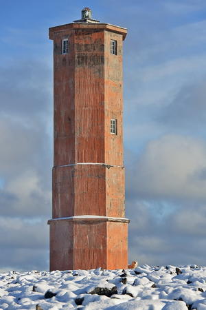
Date unknown. Active; focal plane 39 m (128 ft); white light, 2 s on, 6 s off. 14 m (46 ft) octagonal concrete tower. Sergey Shulinin's view from the sea is at right but the island does not appear in Google's satellite view. This lighthouse was built as a memorial to the seamen of the Soviet icebreaker Sibiryakov, which was sunk near the island by the German pocket battleship Admiral Scheer in August 1942. Located on a barren island at the western end of the Shren group. Accessible only by boat. Site status unknown. Admiralty L9462; NGA 17340.
Ostrov Gydoyamo
Date unknown. Active; focal plane 46 m (151 ft); white flash every 6 s. 12 m (39 ft) square pyramidal wood skeletal tower. No photo available and Google has only a very distant satellite view of the island. Located on an island at the northeastern end of the Shren group. Accessible only by boat. Site status unknown. Admiralty L9464; NGA 17344.
Mys De-Kolonga
Date unknown. Active; focal plane 48 m (157 ft); white flash every 4 s. 8 m (26 ft) square pyramidal wood skeletal tower, with a "rectangular superstructure" according to NGA. No photo available and Google has only a very distant satellite view of the area. Located on an island tenuously connected to the mainland east of the Shren group. Accessible only by boat. Site status unknown. Admiralty L9466; NGA 17348.
Ostrov Ledyanoy
Date unknown. Active; focal plane 17 m (56 ft); white flash every 9 s. 8 m (26 ft) square pyramidal wood skeletal tower. No photo available and Google has only a very distant satellite view of the island. Located on a small island close to the Taymyr coast about 25 km (15 mi) east of Mys De-Kolonga. Accessible only by boat. Site status unknown. Admiralty L9467; NGA 17352.
Ostrov Belukhi Light
Ostrov Belukhi Light, Shren Islands, 2014
Polar Post photo by Sergey Shulinin

Matisen Strait Lighthouses

The Matisen Strait is a narrow passage between the Taymyr Peninsula and the Nordenskjöld Archipelago. The strait is named for Fyodor Matisen, the captain of the ship Zarya that explored and mapped this area in the Russian Polar Expedition of 1900-03.

Ostrov Prady
Date unknown. Active; focal plane 30 m (98 ft); one long white flash every 12 s. 11 m (36 ft) square pyramidal wood skeletal tower. No photo available and Google has only a very distant satellite view of the island. This important light marks the western entrance to the Matisen Strait. Located on an island on the south side of the strait. Accessible only by boat. Site status unknown. Admiralty L9470; NGA 17360.
Ostrov Skalistyy
Date unknown. Active; focal plane 13 m (43 ft); white flash every 4 s. 12 m (39 ft) square pyramidal wood skeletal tower. Google has only a very fuzzy satellite view of the island. Located on an island on the south side of the strait, at about the midway point. Accessible only by boat. Site status unknown. Admiralty L9473; NGA 17368.
Ostrov Moiseyevka
Date unknown. Active; focal plane 52 m (171 ft); white flash every 5 s. 8 m (26 ft) square pyramidal wood skeletal tower. No photo available and Google has only a very distant satellite view of the island. Located on an island on the south side of the strait at the eastern entrance. Accessible only by boat. Site status unknown. Admiralty L9475; NGA 17372.
Ostrov Bliznetsy
Date unknown. Active; focal plane 27 m (89 ft); white light, 2 s on, 6 s off. 12 m (39 ft) square pyramidal wood skeletal tower. Lightphotos.net has Dmitry Lobusov's view from the sea and Google has only a very fuzzy satellite view of the island. Located on an island in the eastern entrance to the strait. Accessible only by boat. Site status unknown. Admiralty L9476; NGA 17392.
Ostrov Malyy
Date unknown. Active; focal plane 18 m (59 ft); white flash every 5 s. 9 m (30 ft) square pyramidal wood skeletal tower. No photo available and Google has only a very fuzzy satellite view of the island. Located on an island about 25 km (15 mi) east of Ostrov Bliznetsy. Accessible only by boat. Site status unknown. Admiralty L9476.5; NGA 17396.
Mys Oskara
Date unknown. Active; focal plane 24 m (79 ft); white flash every 10 s. 15 m (49 ft) square pyramidal wood skeletal tower. No photo available and Google has only a very fuzzy satellite view of the island. Located on a promontory of the mainland at the tip of the Oskar Peninsula, about 50 km (30 mi) east of the Ostrov Tyrtova light (see below). Site status unknown. Admiralty L9477.1; NGA 17404.

Nordenskiöld Archipelago Lighthouses

The Nordenskiöld Archipelago (Arkhipelag Nordenshel'da in Russian) is a large and complex group of islands off the north coast of the Taymyr Peninsula. For vessels eastbound along the Siberian coast, the islands lie in the approach to the Vilkitsky Strait, an important passage of the Northern Sea Route. The islands were named by the Norwegian explorer Fridtjof Nansen for the Finland-Swedish explorer Adolf Erik Nordenskiöld.

Ostrov Makarova
Date unknown. Active; focal plane 33 m (108 ft); white flash every 4.5 s. 12 m (39 ft) square pyramidal wood skeletal tower. No photo available and Google has only a very fuzzy satellite view of the island. Located at the westernmost tip of the archipelago. Accessible only by boat. Site status unknown. Admiralty L9472; NGA 17356.
Ostrov Russkiy Southwest
Date unknown. Active; focal plane 24 m (79 ft); one long white flash every 5 s. 20 m (66 ft) square pyramidal wood skeletal tower. No photo available and Google has only a very fuzzy satellite view of the location. Ostrov Russkiy is the largest and northernmost island of the Nordenskjöld Archipelago; the island is about 80 km (50 mi) long southwest to northeast. Located on the southwestern tip of the island. Site status unknown. Admiralty L9478; NGA 17388.
Ostrov Russkiy North (2?)
Date unknown. Active; focal plane 23 m (75 ft); one long white flash every 6 s. 10 m (33 ft) light mounted atop a station building. A 2014 view from the sea is at right, and Lightphotos.net has a historic photo, but Google has only a very fuzzy satellite view of the cape. This light is on a building of the Ostrov Russkiy polar observatory, founded in 1935 but closed in 1999. Located on the northern tip off Ostrov Russkiy, which is also the northernmost point of the archipelago. Site status unknown. Admiralty L9479; NGA 17384.
Ostrov Shvetsova
Date unknown. Active; focal plane 26 m (85 ft); white flash every 10 s. 13 m (43 ft) square pyramidal wood skeletal tower. Google has only a distant satellite view of the island. Located on a small island marking the preferred channel through the southern part of the archipelago. Site status unknown. Admiralty L9474; NGA 17376.
Ostrov Tyrtova
Date unknown. Active; focal plane 28 m (92 ft); white flash every 4.5 s. 12 m (39 ft) "structure," presumably a station building. No photo available and Google has only a very fuzzy satellite view of the island. There was a polar observatory based on Ostrov Tyrtova from 1940 to 1975. Located at the southern tip of the island, which is also the southeasternmost tip of the archipelago. Accessible only by boat. Site status unknown. Admiralty L9477; NGA 17397.

Ostrov Russkiy North Light, Nordenskjöld Archipelago, September 2014
ex-Panoramio photo copyright Moby Dick; used by permission

Vilkitsky Strait Lighthouses
The Vilkitsky Strait is the passage between Cape Chelyuskin, the northern tip of the Taymyr Peninsula, and Ostrov Bol'shevik, the southernmost of the three main islands of the Severnaya Zemlya ("Northern Land") archipelago. This strait, about 55 km (34 mi) wide, is a key passage in the Northern Sea Route connecting the Kara Sea and the Laptev Sea.

Ostrova Firnleya (Firnley Islands)
Date unknown. Active; focal plane 30 m (98 ft); white flash every 7.5 s. 8 m (26 ft) square pyramidal wood skeletal tower. No photo available and Google has only a very fuzzy satellite view of the island chain. Located on the southwesternmost of the Firnley Islands, about 50 km (30 mi) southwest of the western entrance of the strait. Accessible only by boat. Site status unknown. Admiralty L9478.5; NGA 17412.
Mys Neupokoyeva (Ostrov Bol'shevik)
Date unknown. Active; focal plane 20 m (66 ft); white light, 2 s on, 8 s off. 9 m (30 ft) square pyramidal wood skeletal tower. No photo available and Google has only a very fuzzy satellite view of the location. Located at the southwestern tip of Ostrov Bol'shevik, the southernmost point of Severnaya Zemlya and the north side of the entrance to Vilkitsky Strait. Accessible only by boat. Site status unknown. Admiralty L9485; NGA 17428.
Ostrova Geyberga (Heiberg Islands) (2)
Date unknown. Active; focal plane 31 m (102 ft); white flash every 9 s. 8 m (26 ft) octagonal cylindrical wood skeletal tower. Lighthouse painted orange. Vladimir Melnik's photo is at right but Google has only a fuzzy satellite view of the island. The Heiberg Islands lie in the center of the western entrance to the strait. A 1983 photo showed a light atop the polar station in the islands and a 2008 aerial photo confirmed that this station building still stands, but without the light. (Neither photo remains online.) The modern light is located at the eastern tip of the islands. Accessible only by boat. Site status unknown. Admiralty L9488; NGA 17416.
Ostrov Gansena
Date unknown. Active; focal plane 15 m (49 ft); white flash every 5 s. 8 m (26 ft) square pyramidal wood skeletal tower. No photo available and Google has only a very fuzzy satellite view of the island. Located on an island off the Taymyr Peninsula coast about 50 km (30 mi) southwest of Cape Chelyuskin. Accessible only by boat. Site status unknown. Admiralty L9489; NGA 17424.

Heiberg Islands Light, Vilkitsky Strait
photo copyright Vladimir Melnik; permission requested
Mys Chelyuskina (Cape Chelyuskin) (3?)
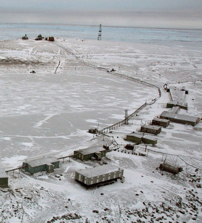
Date unknown (station established 1878). Active; focal plane 41 m (134 ft); one long white flash every 10 s. 17 m (56 ft) square skeletal tower. An aerial view is at right, Google has the same view, and another distant view (first photo on the lower half of the page) shows an earlier light, but Google has only a very fuzzy satellite view of the cape. Cape Chelyuskin is the northernmost point of the Eurasian mainland, at latitude 77°44' north. The cape is named for its discoverer, Semion Chelyuskin, who reached this point overland in 1742. A stone cairn and a small unlit beacon were built here in 1878 by the Swedish explorer Adolf Erik Nordenskjöld, who went on to complete the first successful passage of the Northern Sea Route. These structures still stand. There has been a weather station on the cape since 1932. Located on heights at the cape. Site presumably open, tower closed. Admiralty L9494; NGA 17432.
Mys Shcherbina
Date unknown. Active; focal plane 54 m (177 ft); white flash every 5 s. 13.5 m (44 ft) square pyramidal wood skeletal tower. No photo available and Google has only a very fuzzy satellite view of the cape. Located on a cape about 15 km (9 mi) east southeast of Cape Chelyuskin. Site status unknown. Admiralty L9496; NGA 17444.
Mys Pronchishcheva
Date unknown. Active; focal plane 22 m (72 ft); white flash every 2 s. 12.5 m (41 ft) square pyramidal wood skeletal tower. No photo available and Google has only a very fuzzy satellite view of the cape. Located "in the vicinity" (according to NGA) of a prominent cape about 80 km (50 mi) southeast of Cape Chelyuskin. Site status unknown. Admiralty L9500; NGA 17448.

Severnaya Zemlya Lighthouse
Ostrov Sredny
Date unknown. Inactive. Approx. 8 m (26 ft) square pyramidal wood skeletal tower. Maria Gavrio has a closeup photo and Google has only a fuzzy satellite view of the area. Located on a small island at the northwestern corner of October Revolution Island, the central and largest island of the Severnaya Zenmlya group. Site status unknown.
Cape Chelyuskin
Cape Chelyuskin (Mys Chelyuskina) Light, March 2007
City of Vorkuta photo

Laptev Sea Lighthouses
Ostrov Andreya
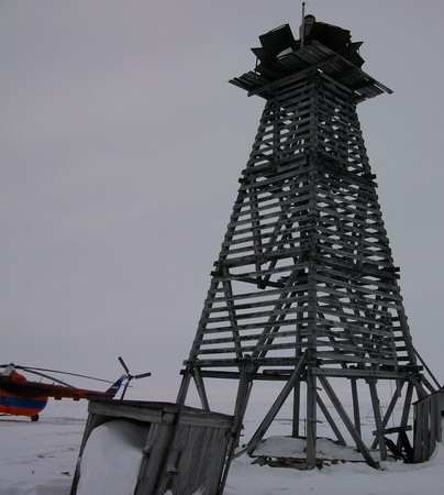
Date unknown. Active; focal plane 31 m (102 ft); white flash every 5 s. 18 m (59 ft) square pyramidal wood skeletal tower. A photo is at right but Google has only a very fuzzy satellite view of the island. Located on an island a short distance off the mainland coast about 240 km (150 mi) southeast of Cape Chelyuskin. Site status unknown. NGA 17456.
Ostrova Petra (Ostrov Severnyy)
Date unknown. Active; focal plane 19 m (62 ft); white light, 2 s on, 6 s off. 10 m (33 ft) square pyramidal wood skeletal tower. Svetlana Evfratova has a photo but Google has only a very fuzzy satellite view of the area. Located on or near the northern tip of Ostrov Severnyy about 65 km (40 mi) southeast of Ostrov Andreya. Site status unknown. NGA 17460.
Ostrova Yuzhnyy
Date unknown. Active; focal plane 18 m (59 ft); two white flashes every 10 s. 10 m (33 ft) square pyramidal wood skeletal tower. No photo available and assuming NGA has the right coordinates the island does not appear in Google's satellite view. Located on a small island off the northeastern tip of the Taymyr Peninsula. Site status unknown. NGA 17464.
Ostrov Psov
Date unknown. Probably inactive, but listed with focal plane 37 m (121 ft); white flash every 5 s. 18 m (59 ft) square pyramidal wood skeletal tower. Endangered: Svetlana Evfratova's 2016 photo shows the tower leaning into the sea. Google has only a very distant satellite view of the island. Located on the northern tip of an island off the easternmost extension of the Taymyr Peninsula. Site status unknown. NGA 17468.

Khatanga Gulf Lighthouses

The Khatanga Gulf is a 220 km (135 mi) long estuary at the base of the Taymyr Peninsula; it forms part of the boundary between the Sakha Republic and the Taymyria district. An island, Ostrov Bol'shoy Begichev, separates the mouth of the gulf into two straits, northern and eastern.

Mys Kul'cha
Date unknown. Active; focal plane 38 m (125 ft); white flash every 2 s. 11 m (36 ft) square pyramidal wood skeletal tower. No photo available and Google has only a very distant satellite view of the cape. Located on a prominent cape in the southern portion of the gulf, marking the entrance to the Kozhevnikov Bay. Site status unknown. NGA 17496.
Ostrov Andreya
Ostrov Andreya Light, Laptev Sea, September 2010
ex-Panoramio photo copyright Romikass; used by permission

Information available on lost lighthouses:

Notable faux lighthouses:

Adjoining pages: East: Sakha Republic | West: Yenisey Gulf

Return to the Lighthouse Directory index | Ratings key

Posted January 7, 2012. Checked and revised January 12, 2023. Lighthouses: 42. Site copyright 2023 Russ Rowlett and the University of North Carolina at Chapel Hill.