Lighthouses of Russia: Yamalo-Nenetsia

Russia (Россия, Rossiya in Russian) is by far the world's largest country, spanning a little over 150° in longitude. It is organized as the Russian Federation (Rossiyskaya Federatsiya) with members known as federal subjects (sub'yekty federatsii). Russia is primarily a continental nation but it has important coastlines on the Baltic, Black, and Caspian Seas and very long coastlines on the Arctic Ocean and North Pacific Ocean. To guard these coasts it operates hundreds of lighthouses, many of them historic.

Yamalo-Nenetsia, more precisely the Yamalo-Nenets Autonomous Okrug, is at the northwestern corner of Siberia surrounding the long estuary of the Gulf of Ob, the lower course of the Ob River. It is one of the members of the Russian Federation. Although the Gulf is relatively shallow shipping in smaller vessels is heavy during the warmer months and the Gulf has many lighthouses. Practically no information is available concerning these lights, so additional information is needed and would be welcome.

The Russian word for a lighthouse is mayak (маяк); ostrov is an island, poluostrov is a peninsula, mys is a cape, bukhta or guba is a bay, zaliv is a larger bay or gulf, proliv is a strait, reka is a river, and gavan' is a harbor.

Russian lighthouses are owned by the Russian Navy and maintained by the Navy's Office of Navigation and Oceanography (Управление навигации и океанографии).

ARLHS numbers are from the ARLHS World List of Lights. Russian light list (RU) numbers are from Russian Navy Publication 2111 (Kara Sea) as reported by the Admiralty. Admiralty numbers are from volume L of the Admiralty List of Lights & Fog Signals. U.S. NGA numbers are from Publication 115. In recent years most of the lights of the Gulf of Ob have been dropped from the Admiralty and NGA lists. This is probably the result of a decision by the Admiralty to not list lights of Russian inland waterways.

General Sources
World of Lighthouses - Russia Arctic Ocean
Photos available from Lightphotos.net.
Online List of Lights - Russia - Arctic Sea Coast
Photos by various photographers posted by Alexander Trabas.
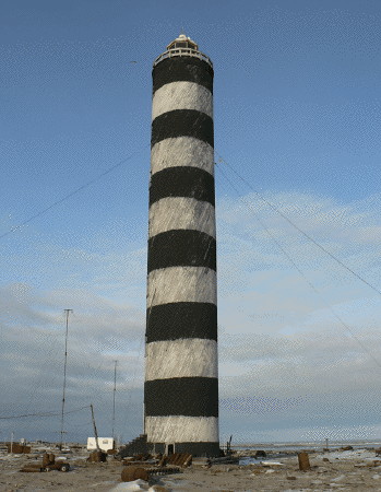
Vil'kitskiy Light
Vil'kitskiy Light, summer 2010
Polar Post photo
West Side Yamal Peninsula and Ostrov Belyy Lighthouses
The Yamal Peninsula projects 700 km (435 mi) into the Kara Sea along the west side of the Ob Estuary (Gulf of Ob).

Mys Ponton
Date unknown. Active; focal plane 13 m (43 ft); white flash every 6 s. 11 m (36 ft) square pyramidal tower, upper portion painted black. No photo available and Google has only a fuzzy satellite view of the area. Located on a prominent cape on the west side of the Yamal Peninsula. Site status unknown. RU 2111-0825; Admiralty L8016.5.
Chernyy Bereg
Date unknown. Active; focal plane 41 m (135 ft); white flash every 3 s. 12 m (39 ft) pyramidal tower carrying a daymark painted black with a white vertical stripe. No photo available but the shadow of a tower is seen in Google's satellite view. Located near a settlement on the west side of the Yamal Peninsula. Site status unknown. RU 2111-0850; Admiralty L8022; NGA 16868.
Yun'yakha
Date unknown. Active; focal plane 23 m (75 ft); white flash every 3 s. 18 m (59 ft) pyramidal tower with two white triangular daymarks, points up. No photo available and Google's satellite view of the area has no detail. Located at a settlement on the west side of the Yamal Peninsula about 40 km (25 mi) northeast of Chernyy Bereg. Site status unknown. RU 2111-0855; Admiralty L8026; NGA 16872.
Seda (Reka Khayde-Yakha-Seday)
Date unknown. Active; focal plane 33 m (108 ft); white flash every 8 s. 17 m (56 ft) pyramidal tower, black with three shields painted with black and white horizontal bands. No photo available and Google has only a fuzzy satellite view of the area. Located about 55 km (35 mi) north of Yun-Yakha. Site status unknown. RU 2111-0860; Admiralty L8030; NGA 16876.
Mys Payntde
Date unknown. Active; focal plane 23 m (75 ft); white flash every 5 s. 11 m (36 ft) pyramidal wood tower, black with a white vertical stripe. No photo available and Google's satellite view of the area has no detail. Located on a promontory about 35 km (22 mi) south of northwestern corner of the Yamal Peninsula. Site status unknown. RU 2111-0865; Admiralty L8044; NGA 16880.
Ostrov Belyy Severnyy (Belyy Island North)
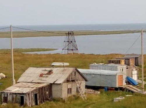
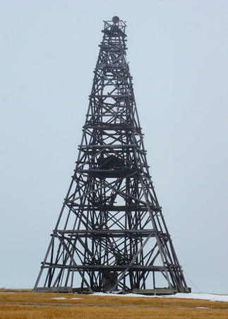
Date unknown (probably 1933). Active; focal plane 22 m (72 ft); white flash every 5 s. 21 m (69 ft) wood skeletal tower, painted black. Roman Spaskov's photo is at right, S. Anisimov has a photo, Timur Abdrashitov has a closeup photo, and a distant view is available, but Google's satellite view of the area has no detail. Ostrov Belyy (White Island) is an island off the northern tip of the Yamal Peninsula, so this light is important for guiding vessels around the peninsula. A polar station was established here in 1933 and staffed throughout the Soviet era. Today the buildings are abandoned, but an automatic weather station remains. Located on the northern tip of the island. Site status unknown. RU 2111-0920; Admiralty L8047; NGA 16888.
Mys Shuberta
Date unknown. Active; focal plane 19 m (62 ft); white flash every 6 s. 17 m (56 ft) square pyramidal tower, painted black with a white band. No photo available and Google's satellite view of the area has no detail. Located on the southeastern tip of Ostrov Belyy. Site status unknown. RU 2111-0900; Admiralty L8048; NGA 16890.
Belyy Severnyy Light
Belyy Severnyy Light, Ostrov Belyy, June 2012
ex-Panoramio photo copyright Roman Spaskov
used by permission

Gulf of Ob Lower West Side Lighthouses

The Gulf of Ob is the long estuary forming the lower course of the Ob River, the westernmost of Siberia's three great river systems. The gulf is roughly 1000 km (600 mi) long and generally 50-80 km (30-50 mi) wide; it is the longest estuary in the world.

Mys Poyelovo
Date unknown. Active; focal plane 25 m (82 ft); white flash every 8 s. 15 m (49 ft) square pyramidal tower, upper portion painted black. No photo available but Google has a satellite view that probably shows the lighthouse. Located about 16 m (10 mi) northwest of Cape Drovyanoy (next entry) on the west side of the entrance to the Ob Gulf. Site status unknown. RU 2111-1020; Admiralty L8052; NGA 16892.
Mys Drovyanoy
Date unknown. Active; focal plane 24 m (79 ft); white flash every 5 s. 23 m (75 ft) square pyramidal tower with gallery, upper portion painted black. No photo available and Google's satellite view of the area has no detail. Located on an island marking the west side of the entrance to the Ob Gulf. Site status unknown. RU 2111-1025; Admiralty L8053; NGA 16896.
Mys Drovyanoy South
Date unknown. Active; focal plane 21 m (69 ft); white flash every 8 s. 18 m (75 ft) square pyramidal tower, painted black. No photo available and Google's satellite view of the area has no detail. Located near the south end of the same island as the Mys Drovyanoy light. Site status unknown. RU 2111-1030; Admiralty L8054.
Yarra-yaga (Nerva-yakha)
Date unknown. Active; focal plane 16 m (52 ft); one long white flash every 10 s. 15 m (49 ft) square pyramidal tower, painted black. No photo available and Google's satellite view of the area has no detail. Located at a river delta about 50 km (30 mi) south of Mys Drovyanoy. Site status unknown. RU 2111-1045; Admiralty L8054.5.
Tambey
Date unknown. Active; focal plane 25 m (82 ft); white flash every 5 s. 15 m (49 ft) square cylindrical skeletal tower carrying a black rectangular daymark. A distant view is available (a little over 1/3 the way down the page) and the shadow of the lighthouse is prominent in Google's satellite view. Located on the north side of Tambey, a settlement on a sheltered embayment on the west side of the gulf. Site status unknown. RU 2111-1060; ex-Admiralty L8064; ex-NGA 16905.
Mys Poruy
Date unknown. Active; focal plane 12 m (39 ft); white flash every 3 s. 11 m (36 ft) square pyramidal tower, painted black and white. No photo available and Google's satellite view of the area has no detail. Located about 45 km (28 mi) south of Tambey. Site status unknown. RU 2111-1093; ex-Admiralty L8070.

Gulf of Ob Upper West Side Lighthouses
Mys Kamennyy (2?)
Date unknown. Active; focal plane 21 m (69 ft); white flash every 5 s. 18 m (59 ft) skeletal tower. Roman Spaskov's photo is at right, a distant drone view is available, and Google has an indistinct satellite view. Located at Mys Kamenyy, a town on the west side of the gulf a short distance south of the Taz Estuary. Site status unknown. RU 2111-1160; ex-Admiralty L8100; ex-NGA 16948.
Yarayakha
Date unknown. Active; focal plane unknown; white flash every 6 s. 13 m (43 ft) square pyramidal tower, painted black. No photo available and Google's satellite view of the area has no detail. Located at a river delta about 40 km (25 mi) south of Mys Kamennyy. Site status unknown. RU 2111-1177; ex-Admiralty L8103.

Mys Kamennyy Light, Mys Kamennyy, September 2011
Google Maps photo by Roman Spaskov
Marasalya (Mar Sale) Kosa (2)
Date unknown. Active; focal plane unknown; white flash every 5 s. 13 m (43 ft) square pyramidal tower, painted black with a white horizontal band. No photo available but Google has a satellite view. Located at the end of a spit that shelters Novy Port ("new port"), a settlement on the west side of the gulf. Site status unknown. RU 2111-1180; ex-Admiralty L8104.5; NGA 16960.
Novy Port Range Front
Date unknown. Inactive but listed with focal plane and light characteristic unknown. Approx. 12 m (39 ft) square skeletal tower. Nikolay Goryushkin's photo at right shows that the light is abandoned; Google has a distant satellite view. Located on the east side of Novy Port. Site status unknown. Admiralty L8104.2.
Novy Port Range Rear
Date unknown. Inactive but listed with focal plane and light characteristic unknown. Approx. 12 m (39 ft) square skeletal tower. Boris Gritsayuk has a distant street view and Google has a satellite view. Located about 300 m (0.2 mi) northwest of the front light. Site status unknown. Admiralty L8104.3.
Mys Ostrovskoy
Date unknown. Active; focal plane 16 m (52 ft); white flash every 8 s. 11 m (36 ft) skeletal tower carrying an orange daymark. No photo available but Google has a satellite view. Located about 20 km (13 mi) southwest of Marasalya Kosa. Site status unknown. RU 2111-1193; ex-Admiralty L8104.4; NGA 16984.
Mys Botkina
Date unknown. Active; focal plane 17 m (56 ft); white flash every 5 s. 15 m (49 ft) square pyramidal tower, painted with black and white horizontal bands. No photo available and Google's satellite view of the area has no detail. Located on a cape on the west side of the upper gulf. Site status unknown. RU 2111-1210; ex-Admiralty L8107; NGA 16968.
Mys Yam Sale
Date unknown. Active; focal plane 20.5 m (67 ft); white flash every 3 s. 19 m (62 ft) square pyramidal wood tower. No photo available and Google's satellite view of the area has no detail. Located on a cape on the west side of the upper gulf. Site status unknown. NGA 16972.

Range Front Light, Novy Port, August 2018
Google Maps photo by Nikolay Goryushkin
 

Gulf of Ob Upper East Side Lighthouses
Yamburg
Date unknown. Active; focal plane unknown; white flash every 8 s. 12 m (39 ft) square pyramidal tower, painted black with a white vertical stripes. No photo available but Google has a satellite view that may show the light. Located at the settlement of Yamburg, a company town that supports the nearby natural gas field on the upper west side of the gulf. Site status unknown. RU 2111-1155; ex-Admiralty L8104.9.
Mys Kruglyy (2)
2011 (station establishment date unknown). Active; focal plane 48 m (157 ft); one long white flash every 5 s. 9 m (30 ft) square pyramidal tower, painted red. No photo available and Google's satellite view of the area has no detail. Located on a prominent cape on the south side of the entrance to the Taz Estuary, an eastern branch of the Gulf of Ob. Site status unknown. RU 2111-1140; ex-Admiralty L8115; NGA 16936.

Taz Estuary (Tazovskaya Guba) Lighthouses
The Taz River is a major tributary of the Ob. Its lower course forms an estuary that is an eastern branch of the Gulf of Ob.
Mys Povorotnyy
Date unknown. Active; focal plane 68 m (223 ft); white flash every 3 s. 16 m (52 ft) square pyramidal skeletal tower carrying a daymark painted with horizontal red and yellow bands. Aigars Purins has the distant view from the water seen at right but Google's satellite view of the area has no detail. Located on a promontory marking a right-angle bend in the Taz Estuary. Site status unknown. RU 2111-1350; ex-Admiralty L8115.52; NGA 16940.
Mys Poylovosalya (Poylovo-Yakha)
Date unknown. Active; focal plane 19 m (62 ft); white flash every 5 s. 18 m (56 ft) square pyramidal tower. No photo available and Google's satellite view of the area has no detail. Located at a river delta that forms a prominent cape on the west side of the Taz Estuary. Site status unknown. RU 2111-1360; ex-Admiralty L8115.6; NGA 16944.
Mys Yumborsalya
Date unknown. Active; focal plane 19 m (62 ft); white flash every 2 s. 12 m (39 ft) square pyramidal skeletal tower with a slatted daymark. No photo available and Google's satellite view of the area has no detail. Located on a prominent cape on the west side of the upper Taz estuary. Site status unknown. RU 2111-1365; ex-Admiralty L8115.62.
Nesalya
Date unknown. Active; focal plane unknown; white flash every 2 s. 12 m (39 ft) square pyramidal skeletal tower with a slatted daymark painted black. No photo available but Bing has an indistinct satellite view. Located about 10 km (6 mi) northwest of the Taz River delta. Site status unknown. RU 2111-1385; ex-Admiralty L8115.78.
Mys Povorotnyy Light
Mys Povorotnyy Light, Taz Estuary, June 2009
ex-Panoramio photo copyright Aigars Purins; used by permission
Severnaya Nakhodka
Date unknown. Active; focal plane unknown; white flash every 2 s. 12 m (39 ft) square pyramidal skeletal tower with a slatted daymark painted black. No photo available but Bing has an indistinct satellite view. Located on the northwestern corner of Nakhodka Island, on the east side of the upper Taz estuary. Site status unknown. RU 2111-1380; ex-Admiralty L8115.72.
Plotnikov
Date unknown. Active; focal plane 14 m (46 ft); white flash every 2 s. 13 m (43 ft) square pyramidal skeletal tower with a slatted daymark painted black. No photo available and Google's satellite view of the area has no detail. Located on the east side of the Taz estuary due east of Mys Povorotnyy. Site status unknown. RU 2111-1355; ex-Admiralty L8115.9; NGA 16928.
Shirokiy
Date unknown. Active; focal plane 14 m (46 ft); white flash every 2 s. 13 m (43 ft) square pyramidal skeletal tower with a slatted daymark painted with black and yellow bands. No photo available and Google's satellite view of the area has no detail. Located on the south bank of the Payuta River and the east side of the Taz estuary, opposite Mys Povorotnyy. Site status unknown. RU 2111-1320; ex-Admiralty L8115.85.

Gulf of Ob Lower East Side Lighthouses
Mys Trekhbugornyy
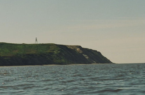
Date unknown. Active; focal plane 74 m (243 ft); white flash every 4 s. 12 m (39 ft) square pyramidal tower, painted red and carrying a trapezoidal slatted daymark. Svetlana Evfratova has a very distant view from the gulf (also seen at right) but Google's satellite view of the area has no detail. Located on a very prominent cape marking the north side of the junction of the Ob and Taz estuaries. Site status unknown. RU 2111-1130; ex-Admiralty L8088; ex-NGA 16916.
Mys Kharse
Date unknown. Active; focal plane 13 m (43 ft); white flash every 6 s. 12.5 m (41 ft) square pyramidal tower. No photo available and Google's satellite view of the area has no detail. Located on a prominent cape on the east side of the gulf opposite Seyakha. Site status unknown. RU 2111-1115; ex-Admiralty L8082; NGA 16908.
Tadibe-Yakha (Tadibeyakha, Tadibe-yaga)
Date unknown. Active; focal plane 36 m (118 ft); white flash every 10 s. 14 m (46 ft) square skeletal tower carrying a daymark painted with red and white vertical stripes. No photo available but Google has a satellite view. Tadibe-Yakha is a former scientific station on the lower Ob, staffed from 1950 until about 1994. Located on a bluff a short distance south of Tadibe-Yakha. Site status unknown. RU 2111-1110; ex-Admiralty L8078.
Mys Khaltsyneysalya (Khaltsyyanay-sale)
Date unknown. Active; focal plane 38 m (125 ft); white flash every 5 s. 14 m (46 ft) triangular pyramidal skeletal tower, painted black with a black vertical stripe. No photo available and Google's satellite view of the area has no detail. Located about 55 km (35 mi) north of Tadibe-Yakha. Site status unknown. RU 2111-1098; ex-Admiralty L8074.

Mys Trekhbugornyy Light, Gulf of Ob, July 2017
Google Maps photo by Svetlana Evfratova
Sabuto
Date unknown. Active; focal plane 19 m (62 ft); one long white flash every 10 s. 18 m (59 ft) skeletal tower. No photo available and Google's satellite view of the area has no detail. Located about 15 km (9 mi) north of Mys Khaltsyneysalya. Site status unknown. RU 2111-1095; ex-Admiralty L8072.
Mys Khonarasalya (Khonorasalya, Khonara-sale)
Date unknown. Active; focal plane 54 m (177 ft); white flash every 3 s. 14 m (46 ft) tower. No photo available and Google's satellite view of the area has no detail. Located on a prominent cape on the east side of the gulf opposite Tambey. Site status unknown. RU 2111-1090; ex-Admiralty L8066; ex-NGA 16906.
Mys Turysale (Mys Yavay)
Date unknown. Active; focal plane 21 m (69 ft); red light, 1.5 s on, 4.5 s off. 9 m (30 ft) triangular skeletal tower "with platform," according to NGA. No photo available and Google's satellite view of the area has no detail. Located on the east side of the entrance to the Gulf of Ob, opposite Mys Poyelovo. Site status unknown. Admiralty L8055; NGA 16994.

Shokalsky and Vilkitsky Island Lighthouses

Shokalsky Island (Ostrov Shokal'skogo) is an island barely separated from the end of the Gydan Peninsula, which forms the east side of the Ob Gulf north of the Taz estuary. Vilkitsky Island (Ostrov Vil'kitskogo) is a smaller island about 40 km (25 mi) northeast of Shokalsky Island.

Ostrov Shokal'skogo
Date unknown. Active; focal plane 22 m (72 ft); white flash every 8 s. 14 m (46 ft) tower. No photo available and Google's satellite view of the area has no detail. Located on the western point of the island, marking the east side of the entrance to the Gulf of Ob. Site status unknown. RU 2111-1075; Admiralty L8050; NGA 16996.
Ostrov Shokal'skogo Severnyy
Date unknown. Active; focal plane 21 m (69 ft); white flash every 5 s. 14 m (46 ft) tower. No photo available and Google's satellite view of the area has no detail. Located on the northern point of the island. Site status unknown. RU 2111-1070; Admiralty L8051; NGA 16998.
Mysovoy
Date unknown. Active; focal plane 16 m (52 ft); white flash every 6 s. 15 m (49 ft) square pyramidal tower. No photo available and Google's satellite view of the area has no detail. Located on the end of a sand spit extending southwestward from Vilkitsky Island. Site status unknown. RU 2111-0950; Admiralty L8202; NGA 17004.
Vil'kitskiy (Ostrov Vil'kitskogo) (2)
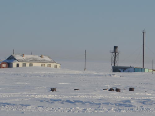
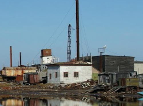
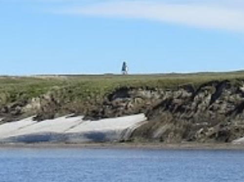
Date unknown. Active; focal plane 35 m (115 ft); white light, 8 s on, 4 s off. 33 m (108 ft) round cylindrical concrete tower with lantern and gallery. Lighthouse painted with black and white horizontal bands; lantern painted white. This is a staffed station. A photo is at the top of this page, a nice view of the station is available, and Svetlana Yevfratova has a view from the sea, but Google has only a fuzzy satellite view of the area. This major lighthouse is the landfall light for the Yenisey Gulf. NGA formerly listed a "wooden truncated pyramid," presumably the earlier lighthouse. The lighthouse is located in an important Russian polar scientific station. Located on the north side of Vilkitsky Island. Accessible only by boat. Site status unknown. ARLHS ASR-071; RU 2111-0945; Admiralty L8200; NGA 17000.

Information available on lost lighthouses:

Notable faux lighthouses:

Adjoining pages: East: Yenisey Gulf | West: Eastern Nenetsia | Northwest: Novaya Zemlya

Return to the Lighthouse Directory index | Ratings key

Created November 28, 2011. Checked and revised December 20, 2022. Lighthouses: 41. Site copyright 2022 Russ Rowlett and the University of North Carolina at Chapel Hill.