Lighthouses of Sudan

The Republic of the Sudan is the third-largest country in Africa but its coastline is limited to about 850 km (530 mi) on the west shore of the Red Sea between Egypt and Eritrea. British forces conquered Sudan in the 1890s and in 1899 the country was placed nominally under joint British and Egyptian rule. In fact Sudan was administered as a British colony until it was granted independence in 1956.

Sudan is divided into 18 states but the coastline is entirely in the Red Sea state. The principal Sudanese port is Bur Sudan (Port Sudan), founded by the British colonial government in 1905 to replace the historic port of Suakin. Although violence has marred the southern and western parts of the country for many years, the coastline has been relatively peaceful and is open to tourism. Coral reefs off the Sudanese coast in the Red Sea attract scuba divers from around the world.

The Arabic word for a lighthouse is mnarh or manara (منارة). Ra's is a cape, jaza'ir or jazirat is an island, shi'b is a reef, khalij is a bay, nahr is a river, and mina' is a harbor. In Sudanese Arabic bur (بور) is a port.

Aids to navigation in Sudan are maintained by the Sudan Sea Ports Corporation.

ARLHS numbers are from the ARLHS World List of Lights. Lights on this page were formerly included in volume E of the Admiralty List of Lights & Fog Signals but in 2013 they were moved to volume D with new numbers. U.S. NGA List numbers are from Publication 112.

General Sources
World of Lighthouses - Sudan
Photos by various photographers available from Lightphotos.net.
Online List of Lights - Sudan
Photos by various photographers posted by Alexander Trabas.
Afrikanische Leuchttürme auf historischen Postkarten
Historic postcard images posted by Klaus Huelse.
Navionics Charts
Navigation chart information for Sudan.


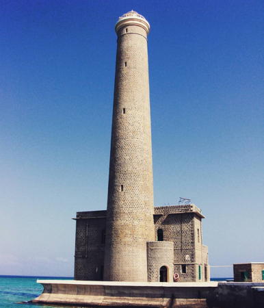
Sanganeb Reef Light, Red Sea, March 2018
Instagram photo by L'Officina dei Viaggi
Northern Red Sea Reef Lighthouses
Abington Reef
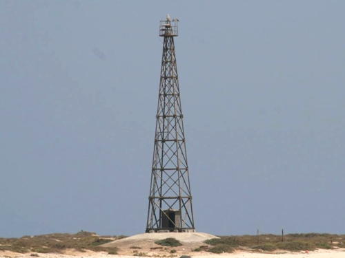
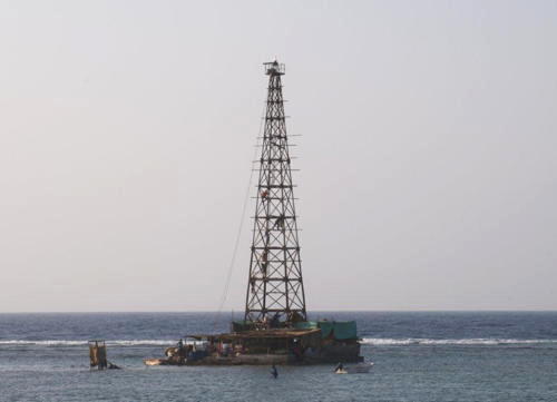
Date unknown. Active; focal plane 30 m (98 ft); two white flashes every 18 s. 30 m (98 ft) square pyramidal iron skeletal tower with gallery, mounted on a square concrete pier. Mariacristina Pulliero has a blog with several photos (one of which is at right) and Bing has a satellite view. This light warns ships away from extensive reefs off the cape of Ra's Abu Shagrab. Located on a reef about 30 km (19 mi) due east of the fishing port of Muhammad Qol (Qawl) in the northeastern corner of Sudan. Like Sanganeb Reef (next entry) this reef is a popular dive site, but it is much more remote than Sanganeb Reef. Accessible only by boat. Site open, tower closed. ARLHS SUD-001; Admiralty D7295.9 (ex-E6058); NGA 30608.
** Sanganeb Reef (2)
Date unknown (station established 1906). Active; focal plane 50 m (165 ft); white flash every 5 s. 50 m (165 ft) concrete tower with lantern and gallery, attached to a 2-story concrete crew quarters. 5th order Fresnel lens in use. Fog horn (3 s blast every 30 s). A 2018 photo is at the top of this page, Clifton Beard has a 2007 photo, Colin Jones also has a closeup 2007 photo, Jonathan Proud has posted numerous photos, another nice photo is available, Talal Elamin has a 2021 photo, and Bing has a satellite view. Sanganeb Reef is one of several very dangerous reefs in the Red Sea east and northeast of Bur Sudan. This light station is one of a chain of stations established by the British on desert islands of the Red Sea to protect shipping between Europe and Asia. It also serves as a landfall light for Bur Sudan. The original lighthouse, seen in a postcard view posted by Huelse, was a wonder of its age, a 55 m (180 ft) skeletal lighthouse similar in design to the Florida Reef lighthouses in the U.S. The present lighthouse is permanently staffed by the Sudanese military as an assertion of Sudanese sovereignty over the reefs. The reef is considered one of the best diving sites in the world and no expedition to the reef is complete without climbing the lighthouse. Located at the south point of the reef about 25 km (16 mi) east northeast of the Bur Sudan entrance. Accessible only by boat; boats can be chartered at Bur Sudan. Site open, tower open by arrangement with the keepers. . ARLHS SUD-003; Admiralty D7295.8 (ex-E6058.5); NGA 30612.

Abington Reef Light, Red Sea, June 2012
photo copyright Mariacristina Pulliero; permission requested
Nimra Talata (Wingate Reef East)
Date unknown. Active; focal plane 7 m (23 ft); three white flashes every 15 s. 7 m (23 ft) concrete tower, painted in a black and white checkered pattern, mounted on a concrete pier. No photo available but Bing has a distant satellite view. Wingate Reef is famous among divers for the wreck of the Umbria, an Italian freighter that sank in June 1940 carrying munitions to Italian troops in East Africa. Located at the northeastern tip of the reef system, about 15 km (9 mi) off the entrance to Bur Sudan. Accessible only by boat. Site open, tower closed. ARLHS SUD-004; Admiralty D7295.79 (ex-E6059); NGA 30620.
Silayet (Wingate Reef South)
Date unknown. Active; focal plane 8.5 m (28 ft); green flash every 3 s. 8 m (26 ft) skeletal tower, painted black, with a white equipment shelter, mounted on a platform supported by piles. No photo available but Google has a distant satellite view. Located at the south end of the reef, about 5 km (3 mi) southwest of Wingate Reef East light. Accessible only by boat. Site open, tower closed. Admiralty D7295.78 (ex-E6059.2); NGA 30616.

Bur Sudan (Port Sudan) Lighthouses
* Bur Sudan Harbor Range Front
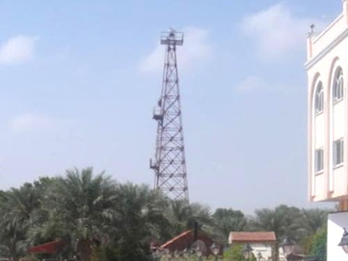
2004. Active; focal plane about 36 m (118 ft); continuous red neon light. 34.5 m (113 ft) square pyramidal skeletal tower. Bashir Muhammed has a photo (a portion is seen at right) and Google has an indistinct satellite view. Located in downtown Port Sudan near the Guests Palace hotel. Site open, tower closed. Admiralty D7295.65 (ex-E6061); NGA 30648.
* Bur Sudan Harbor Range Rear
2004. Active; focal plane about 53 m (175 ft); continuous red neon light. 48 m (157 ft) square pyramidal skeletal communications tower. A photo is available and Google has an indistinct satellite view. Located in downtown Port Sudan 969 m (0.6 mi) northwest of the front light. Site open, tower closed. Admiralty D7295.655 (ex-E6061.1); NGA 30652.

Bur Sudan Harbor Range Front Light, Bur Sudan, March 2011
Google Maps photo by Bashir Muhammed
* Bur Sudan Inner Range Rear
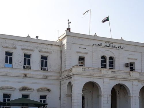
Date unknown. Active; focal plane 21 m (69 ft); two continuous green lights. Mast atop the 2-story Secretariat Building of Red Sea State. The building is white. Paul Kroopkin has a photo (also seen at right), Mahmoud Yassin has a 2021 photo, and Google has a satellite view. Located facing the Corniche in downtown Port Sudan. Site open, tower closed. Admiralty D7295.665 (ex-E6067.1); NGA 30660.
#Bur Sudan (Port Sudan) Pilot Tower
Date unknown. Inactive since 2006 and apparently demolished. This was a 23 m (75 ft) square cylindrical tower with a large observation and control room, topped by radar equipment. The building was white with red-brown trim; from a distance it appeared to have brown and white vertical striping. Sea-seek.com has a small photo. The old tower was located on the south side of the harbor. ARLHS SUD-005; ex-Admiralty E6060.6; ex-NGA 30638.
Damma Damma
Date unknown. Active; focal plane 8 m (26 ft); quick-flashing red light. 8 m (26 ft) skeletal tower, painted in a red and white checkerboard pattern and mounted on a concrete pier. No photo available but Google has an indistinct satellite view. Located off the south side of the entrance to the harbor. Accessible only by boat. Site status unknown. Admiralty D7295.6 (ex-E6060); NGA 30632.
Bur Sudan (Port Sudan) Entrance
Date unknown. Active; focal plane 19 m (63 ft); two white flashes every 10 s. 22 m (72 ft) round stone tower with lantern and gallery, painted black with one white (possibly yellow) horizontal band; lantern painted white. Graham Merg has a distant view and Google has a satellite view. We need a closeup photo of this substantial and historic lighthouse. Located on a usually-submerged sandbar on the south side of the entrance to Bur Sudan. Accessible only by boat. Site status unknown. ARLHS SUD-002; AdmiraltyD7295.5 (ex-E6059.4); NGA 30636.

Inner Range Rear Light, Bur Sudan, December 2016
Google Maps photo by Paul Kroopkin
Al Khair Oil Terminal
Date unknown. Active; focal plane 10 m (33 ft); quick-flashing red light. 10 m (33 ft) round white fiberglass tower. No photo available but Google has a distant satellite view. Located at the end of a reef extending from the oil terminal south of Bur Sudan. Accessible only by boat. Site status unknown. AdmiraltyD7295.3.

Sawākin (Suakin) Reefs Lighthouses
Sawākin, a seaport about 50 km (30 mi) south of Port Sudan, is the terminal for ferries crossing the Red Sea to Jeddah in Saudi Arabia. Prior to the colonial era it was the chief port on this coast. The Sawākin Islands are a large group of low islands and shoals off Sawākin.

Hindī Gider
Date unknown. Active; focal plane 27 m (89 ft); two white flashes every 20 s. Approx. 24 m (79 ft) square skeletal tower, painted red; there appears to be an enclosed workroom in the base of the tower. No photo available and the tower is not seen in Bing's fuzzy satellite view. This reef is often visited by divers. Located on a small island near the northeastern end of the Sawākin archipelago, about 80 km (50 mi) southeast of Port Sudan. Accessible only by boat. Site open, tower closed. Admiralty D7295.031 (ex-E6078); NGA 30684.
Masamirit
Date unknown. Active; focal plane 26 m (85 ft); white flash every 10 s. Approx. 24 m (79 ft) square skeletal tower, painted red; there appears to be an enclosed workroom in the base of the tower. Stefano Colombari has a closeup photo and a view from the sea (halfway down the page) is available, but the tower is not seen in Bing's fuzzy satellite view. Located on Masamirit, a small island near the southeastern end of the Sawākin archipelago. Accessible only by boat. Site open, tower closed. Admiralty D7295.03 (ex-E6082); NGA 30688.

Information available on lost lighthouses:

Notable faux lighthouses:

Adjoining pages: North: Egypt Red Sea | South: Eritrea

Return to the Lighthouse Directory index | Ratings key

Posted July 6, 2005. Checked and revised November 20, 2023. Lighthouses: 13. Site copyright 2023 Russ Rowlett and the University of North Carolina at Chapel Hill.