Lighthouses of El Salvador

The smallest country of Central America, the Republic of El Salvador faces south on the Pacific and borders Guatemala on the west and Honduras on the north. Its ports include Acajutla, in the west of the country, and La Unión on the Gulf of Fonseca in the east.

Almost nothing is known about the history or current status of Salvadoran lights, so additional information from visitors to any of these lighthouses would be very welcome.

In Spanish the word for a lighthouse is faro, baliza is a beacon, isla is an island, cabo is a cape, punta is a promontory or point of land, péñon is a rock, arrecife is a reef, bahía is a bay, ría is an estuary or inlet, estrecho is a strait, río is a river, and puerto is a port or harbor.

Aids to navigation in El Salvador are regulated by the Seaport Authority (Autoridad Marítima Portuaria) and maintained by the respective port authorities in Acajutla and La Unión.

ARLHS numbers are from the ARLHS World List of Lights. Admiralty numbers are from volume G of the Admiralty List of Lights & Fog Signals. NGA Light List numbers are from Publication 111.

General Sources
Online List of Lights - El Salvador
Photos by various photographers posted by Alexander Trabas.
World of Lighthouses - El Salvador
Photos by various photographers posted by Lightphotos.net.


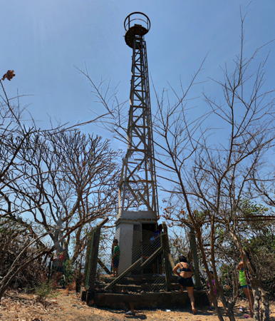
Punta Remedios Light, Los Cóbanos, March 2018
Google Maps street view by Inohjpho
La Unión Department Lighthouses
Isla Zacatillo
Date unknown. Active; focal plane 18 m (59 ft); white flash every 10 s. Approx. 17 m (56 ft) aluminum skeletal tower mounted on a concrete base. No photo available and the light is not seen in dense forest in Google's satellite view. Located on the northwestern point of Isla Zacatillo, about 2.5 km (1.5 mi) northeast of Punta Chiquirin. Accessible only by boat. Site status unknown, possibly open. Owner/site manager: Puerto La Unión. Admiralty G3367; NGA 15388.
Punta Los Negritos
Date unknown. Active; focal plane unknown; white flash every 4 s. Omar Medina has a distant view from Punta Chiquirin showing near the left edge the white lighthouse on the point across the strait and Google has a satellite view. This light and the next one frame the entrance to the Bahía de La Unión from the main body of the Golfo de Fonseca. C-Map charts the focal plane as 11 m (36 ft) but this is clearly much too low. Located at the southeastern tip of Isla Zacatillo, opposite Punta Chiquirin on the mainland. Accessible only by boat. Site status unknown, possibly open. Owner/site manager: Puerto La Unión. Admiralty G3366.5.
Punta Chiquirin (2?)
Date unknown. Active(?); focal plane 21 m (69 ft); white flash every 5 s. Approx. 13 m (43 ft) square skeletal tower. It is not clear if this light still exists, since it is not seen in a 2024 aerial view of the point or in Bing's satellite view of the point. Michel Forand has a historic photo of the original lighthouse, which must have been at a different location. This light and the previous one frame the entrance to the Bahía de La Unión from the main body of the Golfo de Fonseca. Located on the cape, at the southeastern end of El Salvador, about 8 km (5 mi) southeast of La Unión. Site status unknown, possibly open. Owner/site manager: Puerto La Unión. ARLHS ELS-002; Admiralty G3366; NGA 15384.
Punta Amapala (2)
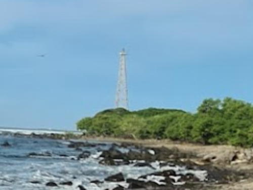
Date unknown. Active; focal plane 27 m (89 ft); one long (1.5 s) white flash every 15 s. 25 m (82 ft) square skeletal tower with gallery, painted white. A portion of a distant 2022 photo is at right and Google has a satellite view. This light marks the west side of the entrance to the Gulf of Fonseca. There is a reference to repairs made to a lighthouse here in 1938. Located on the point of the cape in El Jaguey. Site status unknown. Owner/site manager: Puerto La Unión. Admiralty G3362; NGA 15394.

Distant view of Punta Amapala Light, El Jaguey, August 2022
ex-Google Maps photo by NimVEVO
 

Sonsonate Department (Acajutla Area) Lighthouses
Punta Remedios (2)
Date unknown (station established 1905). Probably inactive but listed with focal plane 25 m (82 ft); white light, 2 s on, 18 s off. 12 m (39 ft) square pyramidal skeletal tower with gallery. The light appears abandoned in a closeup March 2018 street view seen at the top of this page, Trabas has a view from the sea by Capt. Theo Hinrichs, an overhead drone view is available, and Google has a satellite view. The light station was established after a 1902 hurricane wrecked numerous ships in the area. It's possible that the small building seen in Hinrich's photo and the satellite view is the keeper's cottage of the original lighthouse. Located on the cape at Los Cóbanos, southeast of Acajutla. Site open, but some local knowledge is needed to find it; tower closed. Owner/site manager: Puerto de Acajutla. ARLHS ELS-001; Admiralty G3378; NGA 15372.
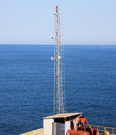
[Acajutla National Pier]
Date unknown. Active; focal plane 26 m (85 ft); continuous red light. Approx. 22 m (72 ft) skeletal mast. Trabas has a closeup photo by Capt. Theo Hinrichs (also seen at right) and Google has a satellite view. Located at the end of the main pier at Acajutla. Site status unknown. Owner/site manager: Puerto de Acajutla. Admiralty G3382; NGA 15368.
Acajutla (2)
Date unknown (station established 1872). Active; focal plane 23 m (75 ft); white light, 6 s on, 6 s off. 7 m (23 ft) square skeletal tower, painted white. There appears to be an enclosed equipment shelter in the base of the tower. Trabas has a photo by Capt. Theo Hinrichs but trees obscure the light in Google's satellite view. The original light was on a mole that no longer exists. Located on the Acajutla waterfront. Site status unknown. Owner/site manager: Puerto de Acajutla. Admiralty G3380; NGA 15364.

Information available on lost lighthouses:

Notable faux lighthouses:


National Pier Light, Acajutla, April 2010
photo copyright Capt. Theo Hinrichs; used by permission

Adjoining pages: North: Guatemala Pacific | South: Nicaragua

Return to the Lighthouse Directory index | Ratings key

Posted July 14, 2010. Checked and revised December 31, 2024. Lighthouses: 7. Site copyright 2024 Russ Rowlett and the University of North Carolina at Chapel Hill.