Lighthouses of Sweden: Öland

The Kingdom of Sweden (Sverige in Swedish) is the largest country of northern Europe, occupying the entire west coast of the Baltic Sea. Along with its lengthy coast Sweden has a distinguished lighthouse history and a good record of preserving its historic lights. The Swedish Lighthouse Society (Svenska Fyrsällskapet) works actively for the preservation of the lighthouses.

Sweden is divided into 21 counties (län) and the counties are subdivided into townships and municipalities (kommuner). Öland is an island in the Baltic Sea belonging to the county of Kalmar (Kalmar Län). A long and narrow island, Öland lies parallel to the mainland coast of Kalmar Län, separated from it by a strait called the Kalmarsund. The island is about 136 km (85 mi) long and 8-16 km (5-10 mi) wide. Since 1972 the island has been readily accessible by the 6 km (3.5 mi) long Öland Bridge (Ölandsbron), which crosses the narrowest part of the Kalmarsund just north of Kalmar. Öland is popular among lighthouse fans for its five historic lighthouses.

The Swedish word for a lighthouse is fyr. The front light of a range is the nedrefyr (lower light) and the rear light is the övrefyr (upper light). Ö is an island, holme is an islet, skär is a skerry (a tiny island or rocky reef), sund is a strait (often between an island and the mainland), vik is a bay, hav is a sea, udde is a headland, and hamn is a harbor.

Aids to navigation in Sweden are maintained by the Swedish Maritime Administration (Sjöfartsverket).

ARLHS numbers are from the ARLHS World List of Lights. SV numbers are from the Sjöfarsverket light list (Svenska Fyrlista) as reported by the Swedish Lighthouse Society. Admiralty numbers are from volume C of the Admiralty List of Lights & Fog Signals. U.S. NGA List numbers are from Publication 116.

General Sources
Swedish Lighthouse Society (Svenska Fyrsällskapet, SFA)
The Society is active in promoting the preservation of Swedish lighthouses.
Svenskt Fyrväsende
From the SFA web site, data and photos for many of the lighthouses.
Lighthouses in Sweden
Aerial photos posted by Marinas.com.
Online Lists of Lights - Sweden - Central Baltic Sea
Photos by various photographers posted by Alexander Trabas.
Lighthouse Pages from Anke and Jens - Sweden
Photos and brief accounts (in English) by two German lighthouse fans.
Leuchttürme und Leuchtfeuer in Schweden - Svenska Fyrar
A large collection of photos and data posted by Erich Hartmann; text in German.
Fyr Vi Har Passeret (Lighthouses We've Passed)
Photos of Baltic lighthouses taken by two Danish sailors, Jette and Ole.
Lighthouses in Sweden
Photos by various photographers available from Wikimedia.
Schwedische Leuchttürme auf historischen Postkarten
Historic postcard views posted by Klaus Huelse.
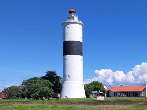

Ölands Södra Udde Light (Långe Jan), Ottenby, June 2022
Google Maps photo by Joerg B
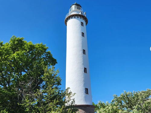

Ölands Norre Udde Light (Långe Erik), Byxelkrok, June 2023
Instagram photo
by Polly & Penny
Borgholm Municipality (North Öland) Lighthouses
[Ispeudde (1)]
1866. Inactive since 1916. 1-1/2 story wood keeper's house painted dark red. SFA has E. Hillberg's photo. The light was displayed from a lantern attached to the house; this lantern was removed when the new lighthouse was built. The house was sold in 1927. Located a short distance northeast of the modern light. Site and tower closed. Owner: private.
* Ispeudde (2)
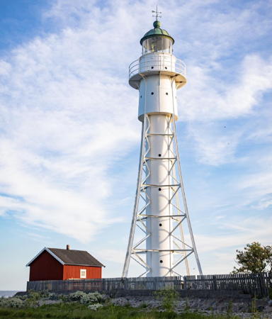
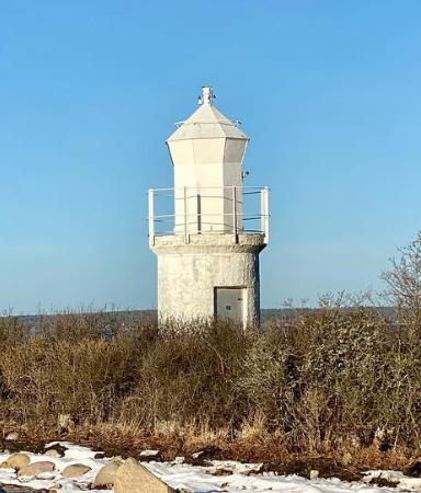
1916 (station established 1866). Active; focal plane 7 m (23 ft); two long (2 s) flashes every 12 s, white, red or green depending on direction. 7 m (23 ft) round solid concrete tower with an octagonal lantern and gallery. Lighthouse painted white. Ove Petersson's 2022 photo is at right, Trabas has a closeup photo, SFA has a page with a photo by Esbjörn Hillberg, Ingrid Rydberg has a 2017 photo, and Google has a satellite view. This light guides both northbound and southbound vessels rounding the Skäggenäs peninsula on the other side of the Kalmarsund. Located at the tip of a peninsula pointing into the Kalmarsund about 8 km (5 mi) north of the Öland bridge. Site open, tower closed. SV-5713; Admiralty C7349; NGA 7908.
Borgholm (2)
1904 (station established 1865). Active; focal plane 5 m (17 ft); white or red light depending on direction. 5 m (17 ft) octagonal cast iron lantern, probably on a concrete base. Lantern painted white. SFA has a page for the lighthouse, the light is nearly hidden by vegetation in Trabas's photo, and Google has a satellite view. The original lighthouse had a lantern mounted on a wood keeper's house. The house was moved to Skäggenäs on the mainland at some time after 1904. Located about 800 m (1/2 mi) southwest of Borgholm. Andreas Köhler reports it is possible to hike about 1.6 km (1 mi) to the light from Borgholm, crossing a pasture to reach the light. Site open, tower closed. SV-5673; Admiralty C7334; NGA 7958.
* [Borgholms Inlopp (Borgholm Outer Harbor) Range Rear]
Date unknown (station established 1874). Active; focal plane 13 m (43 ft); white light, 5 s on, 1 s off. 12.5 m (41 ft) black skeletal mast carrying a large white triangular daymark with a red border. Trabas has Klaus Kern's photo and Google has a street view and a satellite view. This is the tallest of four range lights guiding vessels into the harbor of Borgholm, the largest town on the island. The original light was on a white skeletal tower. Located just off the waterfront. Site open, tower closed. SV-5678.01; Admiralty C7336.1; NGA 7964.
[Hornsudde (2)]
1995 (station established 1893). Inactive since 2001. Hartmann has a page for the light, Anke and Jens have a photo, and Google has a satellite view. This lighthouse was a twin of the Tokanäsudde lighthouse. Anke and Jens photographed it in 1995, but when they returned in 2003 they found the lantern had been removed, leaving only the masonry base, which is still listed as a daybeacon. SFA also has a page for the light. Located on a promontory at Hornsudde on the northwest coast of Öland. Site open, tower closed. ARLHS SWE-200; SV-5570; ex-Admiralty C7312; ex-NGA 8040.

Ispeudde Light, Borgholm, January 2022
Instagram photo
by Ove Petersson
** Tokenäsudde
1955 (station established 1893). Active; focal plane 7 m (23 ft); one long flash every 10 s, white, red or green depending on direction. 6 m (20 ft) square masonry tower with lantern and gallery. Entire lighthouse painted white. SFA has a page for the light, Hartmann has a page with a good photo, Trabas has a closeup, Joakim Nilsson has a 2021 photo, and Google has a street view and a satellite view. Located on a point of land about 800 m (1/2 mi) southwest of Byxelkrok, on the northwest coast of Öland. Site open, with a picnic table next to the lighthouse; visitors can climb to the gallery. SV-5562; Admiralty C7288; NGA 8108.
**** Ölands Norra Udde (Öland North End, "Långe Erik")
1845. Active; focal plane 31 m (102 ft); four white flashes every 15 s. 32 m (105 ft) round limestone tower with lantern and gallery. A rotating beacon on the gallery is in use; the 3rd order Fresnel lens and its rotating mechanism, installed in 1903, remain mounted in the lantern. The fog signal was discontinued in 1985. Lighthouse painted white; lantern dome is gray metallic. A 2023 photo is at the top of this page, Hartmann has a page for the lighthouse, Tanya Ingar has a fine 2007 photo, Trabas has Karl-Heinz Wellm's photo, Radek Gabriel has a 2024 photo, Roberto Moretti has a 2022 closeup, Vil Muhametshin has a street view taken on the gallery, Anke and Jens have photos, Marinas.com has aerial photos, Huelse has a historic postcard view, Fredric Sommer has a street view, and Google has a satellite view. The rotating mechanism was retired in 1947, when the lighthouse was electrified, and the lens was retired in 1991. The lighthouse was repainted in 2023. Located on a small island at the northeastern tip of Öland; accessible by a bridge and causeway. Site open, tower open for climbing (small fee) daily from late June through late August. . ARLHS SWE-298; SV-5475; Admiralty C7260; NGA 7756.
Högby
1898. Active; focal plane 22 m (72 ft); two long (2 s) white flashes every 12 s. 23 m (75 ft) tapered square cast iron skeletal tower with lantern, gallery, enclosed watch room, and central cylinder; 3rd order Fresnel lens in use. Lighthouse painted white; lantern dome is gray metallic. The 2-story stone keeper's house has been sold as a private residence. A 2021 photo is at right, Hartmann has a page for the lighthouse, Trabas has Karl-Heinz Wellm's photo, Mia Jonsson has a 2022 photo, Anke and Jens have a photo, Marinas.com has aerial photos, Huelse has a historic postcard view from the sea, and Google has a satellite view. The lighthouse was prefabricated by Bergsunds Mekaniska Verkstad in Stockholm and exhibited at the Stockholm Exposition in 1897 before its installation. Located at the end of a long, sandy peninsula on the northeast coast of Öland, about 2.5 km (1.5 mi) southeast of Högby. Site and tower closed (private property), but from the number of photos available it appears that the owners will admit polite lighthouse fans. . ARLHS SWE-032; SV-5487; Admiralty C7266; NGA 7752.

Högby Light, Högby, June 2021
Instagram photo
by Migge GP
* Kapelludden
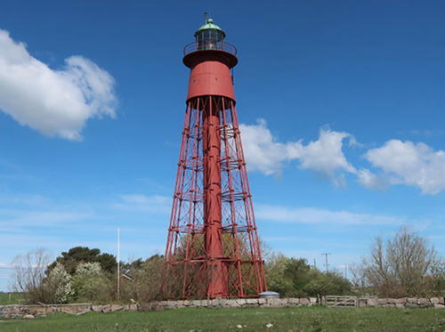
1872 (A.T. Gellerstedt). Active; focal plane 30 m (98 ft); white light, 2 s on, 8 s off. 31.5 m (104 ft) round cast iron skeletal tower with lantern, gallery, enclosed watch room, and central cylinder; 3rd order Fresnel lens in use. Lighthouse painted red; lantern dome is gray metallic. The lighthouse is named Kapelludden (Chapel Point) for the picturesque ruins of St. Birgitta's Chapel located nearby. A photo is at right, Hartmann has a page for the lighthouse, Trabas has Klaus Kern's photo, Anke and Jens have a photo, Wikimedia has several photos, a 2023 photo is available, Marinas.com has aerial photos, Erik Sjöstedt has a 2019 street view, Huelse has a historic postcard view of the chapel ruins and lighthouse, and Google has a satellite view. Located on a point of land on the central east coast of Öland, about 3 km (2 mi) southeast of Bredsättra. Site open, tower closed. . ARLHS SWE-211; SV-5498; Admiralty C7270; NGA 7740.

Mörbylånga Municipality (South Öland) Lighthouses
* Segerstad
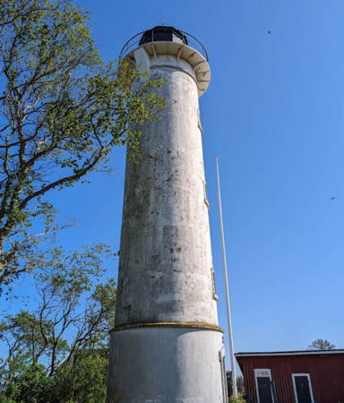
1883. Active; focal plane 21 m (69 ft); three long (2.5 s) flashes every 20 s, white, red or green depending on direction. 22 m (72 ft) round stone tower with lantern and gallery; 4th order Fresnel lens in use. Lighthouse painted white; lantern dome is greenish metallic. 1-1/2 story red brick keeper's house. A 2023 photo is below right, Hartmann has a page for the lighthouse, Bengt Ake Larsson has a good 2007 photo, a 2022 photo is available, Trabas has Klaus Kern's photo, Anke and Jens have a photo, Marinas.com has aerial photos, Huelse has a historic postcard view, and Google has a satellite view. Located on a point of land on the southeast coast of Öland a short distance north of the village of Segerstad. According to Anke and Jens, some local guidance may be needed to find the road to the lighthouse. Site open, tower closed. . ARLHS SWE-057; SV-5515; Admiralty C7274; NGA 7736.

Kapelludden Light, Borgholm, June 2019
Google Maps photo
from www aladdin.st
**** Ölands Södra Udde (Öland South End, "Långe Jan")
1785. Active; focal plane 41 m (135 ft); two white flashes every 30 s; also a continuous passing light at a focal plane of 19 m (62 ft), white, red or green depending on direction. 41.5 m (36 ft) round cylindrical stone tower with lantern and gallery; 3rd order Fresnel lens in use. Lighthouse painted white with one black horizontal band; lantern dome painted red. A 2022 photo is at the top of this page, Hartmann has a page for the lighthouse, Trabas has Klaus Kern's photo, Anke and Jens have a photo, another good photo is available, Marinas.com has aerial photos, Jürgen Tannerstedt has a nighttime street view, Huelse has a historic postcard view, Petrit Gora has a street view, and Google has a satellite view. The surrounding area (the Ottenby Naturreservat) is a nature preserve very popular for birding; the modern keeper's houses have been converted into a visitor center and bird observatory. The historic lighthouse is well kept and was repainted during 2009. Located at the southern tip of Öland. Site open, tower open during the summer season (schedule not available). Site manager: Naturum Ottenby. Parking is provided. . ARLHS SWE-041; SV-5528; Admiralty C7280; NGA 7720.
Ölands Södra Grund (Ölandsrev)
1951 (lightship station established 1919). Active; focal plane 33 m (108 ft); one long white flash every 8 s. 35 m (115 ft) round cylindrical concrete tower, centered on a round 3-story concrete keeper's house, all mounted on a large round caisson. Tower painted black with red horizontal bands; the keeper's house is unpainted gray concrete. Trabas has Capt. Peter Mosselberger's photo, and Wikimedia has a distant view, but the lighthouse is not shown in Google's satellite view. The construction of this tower was a significant engineering accomplishment. Located in the Baltic about 20 km (13 mi) east southeast of the southern tip of Öland. Accessible only by boat. Site open, tower closed. ARLHS SWE-299; SV-5536; Admiralty C7284; NGA 7724.
** [Ingrunden (Utgrunden lantern)]
2004. Inactive; a light is displayed toward the land but is screened from the sea. 10 m (33 ft) round cylindrical tower with lantern and gallery. A 2022 photo is available and Google has a street view and a satellite view. This faux lighthouse carries the original lantern from the Utgrunden lighthouse (see the Kalmar page). It was built as an exhibit of the maritime museum in Degerhamn. The name Ingrunden was selected after a naming contest. Located on the waterfront of Degerhamn, on the southwest coast of Öland. Site open; tower open when the museum is open, on Tuesday and Thursday through Sunday, July 1 through mid August. Owner/site manager: Degerhamns Hembygdsmuseum.

Segerstad Light, Segerstad, June 2023
Google Maps photo by gesla 26.11.

Information available on lost lighthouses:

Notable faux lighthouses:

Adjoining pages: North: Nyköping Area | East: Gotland | West: Kalmar

Return to the Lighthouse Directory index | Ratings key

Posted June 4, 2007. Checked and revised March 5, 2025. Lighthouses: 9. Site copyright 2025 Russ Rowlett and the University of North Carolina at Chapel Hill.