Lighthouses of Timor-Leste (East Timor)

The Democratic Republic of Timor-Leste, generally known in English as East Timor, is the former Portuguese colony on Timor, the southeasternmost major island of the Indonesian archipelago. Colonized by Portugal in the 16th century, Timor-Leste was a remnant of the once-extensive Portuguese Empire in the Indies. Indonesian troops seized the country when Portugal withdrew in 1975. This led to a long struggle for independence until Indonesia withdrew in 1999 and an independent nation was formally established in 2002.

Timor-Leste occupies the eastern half of the island of Timor plus the exclave of Oecusse on the northern coast of Indonesian West Timor. The country is divided into 14 municipalities and has a total population of more than 1.3 million. Dili, located on the north coast, is the capital and the traditional port, but in 2022 a new, modern container port was established at Tibar Bay.

Portuguese remains an official language in Timor-Leste in addition to the indigenous language, Tetum. The Portuguese word for a lighthouse is farol, plural faróis; a small lightbeacon is often called a farolim. In Portuguese ilha is an island, ilhéu is an islet, cabo is a cape, ponta is a promontory or point of land, rocha is a rock, recife is a reef, baía is a bay, estreito is a strait, rio is a river, and porto is a port or harbor.

Aids to navigation in Timor-Leste are presumably operated by the appropriate port authorities. The Port of Dili is now operated by the Timor-Leste Customs Authority and the Port of Tibar Bay is operated by Bolloré Transport and Logistics, a French company, under contract to the government.

ARLHS numbers are from the ARLHS World List of Lights. Admiralty numbers are from volume Q of the Admiralty List of Lights & Fog Signals. U.S. NGA List numbers are from Publication 112.

General Sources
Online List of Lights - Timor-Leste and Oecusse
Photos by various photographers posted by Alexander Trabas; Timor Leste photos were contributed by Jim Smith.
World of Lighthouses - East Timor
Photos by various photographers available from Lightphotos.net.
Lighthouses in East Timor
Photos by various photographers available from Wikimedia.
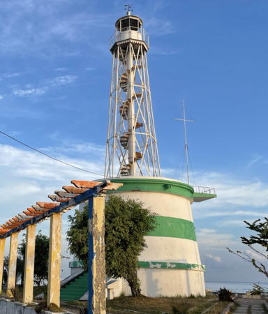

Dili Light, Dili, July 2021
Google Maps photo by Nai-Tú
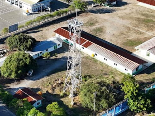
Oecusse Lighthouse
Surrounded by Indonesian West Timor, the Oecusse exclave is an 813.6 km2 (314.1 sq mi) territory separated from the rest of Timor Leste by 58 km (36 mi) of coastline; the distance by road is about 75 km (47 mi). The population of Oecusse is about 70,000.

* Mahata (Oecussi, Oecusse, Oekusi)
Date unknown. Active; focal plane 31 m (102 ft); white flash every 4 s. 27 m (89 ft) square skeletal tower with gallery, painted white. Jonty Crane's 2024 drone view is at right, Aires Sarmento has a 2015 photo, Wikimedia has 2014 a closeup by Regio Da Cruz Salu, Roman Bruehwiler has a 2014 aerial view, and Google has a satellite view. The light predates the development of the modern port, which began with Japanese aid funding in 2011. Located at a port facility near Pante Makassar, the capital of Oecusse, in the eastern part of the exclave. Site open, tower closed. Operator: Timor-Leste Customs Authority. Admiralty Q1365.7; NGA 25702.

Tibar Bay Lighthouses
[Tibar Bay Entrance West]
2022. Active; focal plane about 10 m (33 ft); green flash every 4 s. Approx. 10 m (33 ft) green tower on a round pier. No photo available btut Google has a distant satellite view. Located on the west side of the harbor entrance at Tibar Bay. Accessible only by boat. Site status unknown. Operator: Port of Tibar Bay. Charted by C-Map but not listed by the Admiralty.
[Tibar Bay Entrance East]
2022. Active; focal plane about 10 m (33 ft); red flash every 4 s. Approx. 10 m (33 ft) red tower on a round pier. No photo available and the light is not seen in Google's satellite view. Located on the east side of the harbor entrance at Tibar Bay. Accessible only by boat. Site status unknown. Operator: Port of Tibar Bay. Charted by C-Map but not listed by the Admiralty.
Tibar Bay Range Front
2022. Active; focal plane 13.5 m (44 ft); red light, 2 s on, 2 s off. Approx. 12 m (39 ft) square skeletal tower. No photo available but Google has a satellite view and a distant street view. Located at the end of short jetty on the east side of Tibar Bay, about 16 km (10 mi) west of Dili. Site and tower closed. Operator: Port of Tibar Bay. Admiralty Q1369.8.

Mahata Light, Pante Makassar, August 2024
Google Maps photo by Jonty Crane
Tibar Bay Range Rear
2022. Active; focal plane about 21.5 m (71 ft); red light, 2 s on, 2 s off. Approx. 25 m (82 ft) square skeletal tower. No photo available but Google has a street view and a satellite view. Located about 400 m (1/4 mi) southeast of the front light. Site and tower closed but this tower stands beside a major 4-lane highway. Operator: Port of Tibar Bay. Admiralty Q1369.81.

Dili Lighthouses
#Dili Pertamina (Oil) Depot (1)
Date unknown. Removed in 2020. This was an 8 m (26 ft) square skeletal tower covered with white daymark panels. Trabas has Smith's 2019 photo. The light has been replaced by a light on a post; Google has a 2024 street view but the tower is hard to find in Google's satellite view. Located at the base of the long Pertamina Pier about 2.5 km (1.5 mi) west of the Dili lighthouse. Site status unknown. Admiralty Q1369.5; NGA 25709.7.
* Dili (Tanjung Laguebada)
1896. Active; focal plane 19 m (62 ft); white flash every 6 s. 17 m (56 ft) octagonal skeletal tower with lantern and gallery, rising from a massive masonry base that presumably included the keeper's quarters. Access to the lantern is by an exposed stairway that spirals around a central column. Lighthouse painted white with two green horizontal bands around the base. A 2021 photo is at the top of this page, Wikimedia has David Stanley's 2011 photo, Trabas has a fine photo by Smith, Albert Maramis has a 2009 photo, Wikimedia has Kok Leng Yeo's photo, and Google has a 2024 street view and a good satellite view. For many years the lighthouse was painted all white. Located on the beach on the western side of Dili, the capital of Timor Leste, not far from the U.S. embassy. Site open, tower closed. ARLHS TIM-001; Admiralty Q1368; NGA 25708.
Dili Entrance West
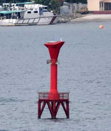
Date unknown. Active; focal plane 12 m (39 ft); green flash every 5 s. 12 m (39 ft) round vase-shaped fiberglass tower colored green, mounted on a platform supported by piles. Trabas has Smith's photo, Takahashi Masaki has a 2013 photo showing the historic lighthouse on the right and the entrance beacons on the left, and Google has a satellite view. Located on the west side of the entrance channel. Accessible only by boat. Site open, tower closed. Admiralty Q1368.3; NGA 25709.5.
Dili Entrance East
Date unknown. Active; focal plane 12 m (39 ft); red flash every 4 s. 12 m (39 ft) round vase-shaped fiberglass tower colored red, mounted on a platform supported by piles. Trabas has Smith's photo (also seen at right), Takahashi Masaki has a photo showing the historic lighthouse on the right and the entrance beacons on the left, and Google has a satellite view. Located on the west side of the entrance channel. Accessible only by boat. Site open, tower closed. Admiralty Q1368.2; NGA 25709.
 

Entrance West Light, Dili, January 2019
photo copyright Jim Smith; used by permission
* Dili Range Front
Date unknown. Active; focal plane about 15 m (49 ft); red flash every 4 s. Approx. 15 m (49 ft) square skeletal tower carrying a red triangular daymark, point up. Ocha Maosawati has a photo, Trabas has Smith's photo, Dedi Suherman has a street view, and Google has an indistinct satellite view and a 2024 street view. Located in front of the Palácio do Governo on the Dili waterfront. Site open, tower closed. Admiralty Q1369; NGA 25708.5.
 
Dili Range Rear
Date unknown. Active; focal plane about 25 m (82 ft); red flash every 4 s. This light is on a short square skeletal tower atop the Office of Business and Industry. Trabas has Smith's photo and Google has a satellite view. Located one block off the waterfront about 100 m (330 ft) southeast of the front light. Site and tower closed. Admiralty Q1369.3.

Lautém Lighthouses
#Kun (Com) Range Front
Date unknown. Removed but still listed with focal plane 11 m (36 ft); white light, 1 s on, 1 s off. 11 m (36 ft) square skeletal tower painted white. This light is on the right in Tiago Larsen's 2020 photo of the range lights, the light can be seen at 0:04 in Antonito Gama's 2020 Google Maps video and Bing has a satellite view but Google's 2024 street view shows no tower. Com is a small beach resort near the northeastern tip of Timor. Located just off the beach in the harbor. Site open, tower closed. Admiralty Q1371; NGA 25717.
Kun (Com) Range Rear (?)
Date unknown. Possibly removed; listed with focal plane 35 m (115 ft); three white flashes every 9 s. Approx. 11 m (36 ft) square skeletal tower painted white. This light is on the left in Tiago Larsen's 2020 photo of the range lights and Google has a distant satellite view. Com is a small beach resort near the northeastern tip of Timor. Located on a steep hillside south of the harbor. Site open, tower closed. Admiralty Q1371.1; NGA 25717.1.
Pulau Jako (Yaco)
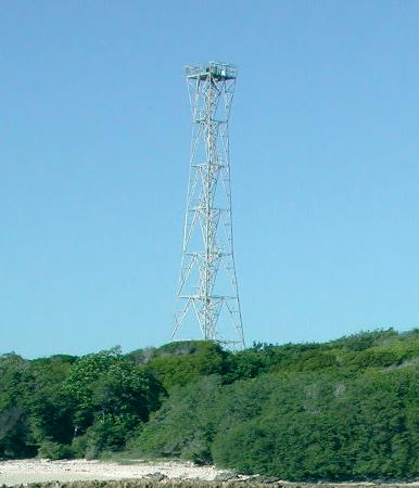
Date unknown. Inactive since 2010 at least. Approx. 35 m (115 ft) square skeletal tower, painted white. Keeper's houses in ruins. Colin Trainor's photo is at right and Google has a satellite view of the station. This lighthouse was built by Indonesia during the years (1975-1999) it held all of Timor. The light was not maintained by Timor Leste after it became independent. Located on a small island off the eastern tip of Timor. Accessible only by boat. Site status unknown. ARLHS TIM-002; ex-Admiralty Q1371.5; ex-NGA 25717.5.
Iliomar
1904. Inactive for many years. Approx. 10 m (33 ft) round stone (or concrete) lighthouse. Wikimedia has a photo by Hans-Peter Grumpe. Iliomar is on the southeast coast of Timor-Leste. The Portuguese built a small fort here in 1904 but the buildings are all in ruins today. Exact location not known; more information is needed.

Jaco Island Light, Jaco Island, 2003
Wikimedia Creative Commons photo by Colin Trainor

Information available on lost lighthouses:

Notable faux lighthouses:

Adjoining page: North: Southern Maluku | West: Rote and West Timor

Return to the Lighthouse Directory index | Ratings key

Posted April 13, 2006. Checked and revised December 12, 2024. Lighthouses: 13. Site copyright 2024 Russ Rowlett and the University of North Carolina at Chapel Hill.