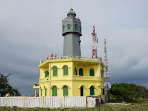
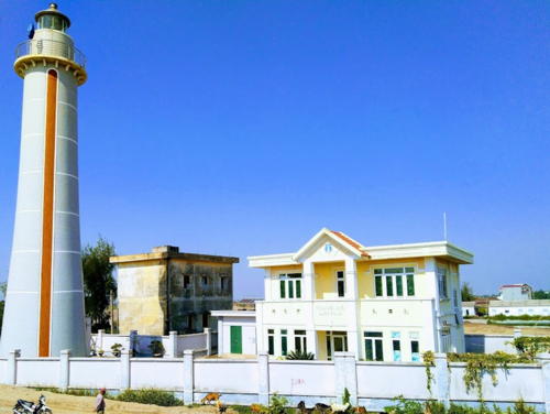
Lighthouses of Northern Vietnam

The Socialist Republic of Vietnam occupies the east coast of Mainland Southeast Asia. After being independent for many centuries Vietnam was colonized by France as part of French Indochina from the mid 1800s until 1941, when the country was invaded and conquered by Japan. After the end of World War II in 1945 French attempts to re-establish control triggered 30 years of warfare. In 1954 an armistice agreement provided for the French withdrawal but divided the country into northern and southern halves. The Vietnam War, a complex struggle between the two Vietnamese governments, was already underway in the late 1950s and escalated with U.S. intervention beginning in 1964. U.S. troops were withdrawn in 1973 and two more years of war led to the reunifucation of the country in 1975.

Vietnam is long and narrow, with a coastline measuring some 3000 km (1875 mi) in length. The northern third of the coast faces the Gulf of Tonkin (Vịnh Bắc Bộ, "Northern Bay" in Vietnamese) and the rest faces east and southeast on the open waters of the South China Sea, known as Biển Đông, "East Sea" in Vietnamese. The Western name Tonkin comes from the Vietnamese Đông Kinh, "Eastern Capital," an old name for Hanoi. During the French colonial era the entire northern region of the country was called Tonkin.

Vietnam is divided into 58 provinces and five province-level municipalities. This page includes the lighthouses of the Gulf of Tonkin coast, from the Chinese border south through Hà Tĩnh Province. This includes most but not all of North Vietnam (the Democratic Republic of Vietnam) as it existed between 1945 and 1975.

Fortunately the lighthouses of Vietnam were not usually seen as targets during the Vietnam War and most of them survived the fighting without major damage. A few of the historic French lighthouses have been replaced but most remain in service and are regarded as historic monuments. In general Vietnamese lighthouses have resident keepers.

The Vietnamese words for a lighthouse are hải đăng or đèn biển ("sea light"). Dao or hòn is an island, quần đảo is an archipelago, bãi cạn is a shoal, mũi is a cape, sông is a river, cửa ("door") is the mouth of a a river, vịnh is a bay, and hải cảng is a harbor.

Aids to navigation are maintained by two Maritime Safety Companies, Vietnam Maritime Safety - North (VMS-North) maintaining lights in the northern half of the country and Southern Vietnam Maritime Safety (SVMS) maintaining the lights of the southern half. All the lights in this area are maintained by VMS-North.

ARLHS numbers are from the ARLHS World List of Lights. Admiralty numbers are from volume F of the Admiralty List of Lights & Fog Signals. U.S. NGA List numbers are from Publication 112.

General Sources
Vietnam Marine Safety North - Lighthouses System
Information in English on many of the major lighthouses.
Vietnam Marine Safety North - Beacon System
An interactive map of lighthouse locations, linking to pages (in Vietnamese) on the individual light stations.
Online List of Lights - Vietnam
Photos by various photographers posted by Alexander Trabas.
World of Lighthouses - Vietnam
Photos by various photographers available from Lightphotos.net.
Lighthouses in Vietnam
Photos by various photographers available from Wikimedia.
Navionics Charts
Navigation chart for the Vietnamese coast.
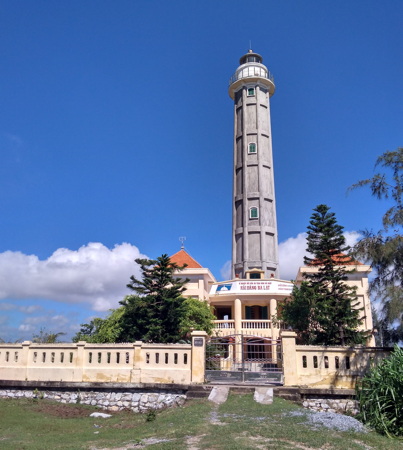
Ba Lạt Light, Thái Bình Province, August 2017
ex-Google Plus photo by Vương Đinh

Quảng Ninh Province Lighthouses

Quảng Ninh Province includes all of the Gulf of Tonkin coast between Hải Phòng and the Chinese border.

Northeast Islands Lighthouses
Vĩnh Thực
1962. Active; focal plane 85 m (279 ft); white flash every 6 s. 18 m (59 ft) round concrete tower with lantern and gallery, attached to a colonnaded 1-story keeper's house. Lighthouse painted yellow with white trim. A photo is right, Dang Linh Nguyen has a 2016 photo, Lam Trinh Khac has a 2017 photo, Giang Pham Hoai has a street view, and Google has a satellite view. Vĩnh Thực is one of Vietnam's largest islands, about 25 km (15 mi) in length, parallel to the coast a few miles south of the Chinese border. There are efforts to develop tourist facilities on the island. Located at the eastern tip of the island, which is also the northeasternmost point of Vietnamese territory. Site status unknown. . ARLHS VIE-007; Admiralty F3315; NGA 20216.5.
Đảo Trần (Lo Chuc Dan)
1996. Active (?); focal plane 201 m (659 ft); four white flashes every 15 s. 18 m (59 ft) square cylindrical concrete tower with lantern and gallery, rising from a keeper's house. Entire structure painted white. Duy Anh Dang has a 2020 photo, Huong Nguyen has a 2015 closeup photo and Huong Nguyen has a view from atop the tower but Google has only a very distant satellite view of the island. This light has been dropped by the Admiralty but it is listed by NGA and it appears on the VMS-North lighthouse map. Đảo Trần is an island about 30 km (20 mi) off the coast of Quảng Ninh province in northernmost Vietnam. The island and its surrounding waters have been proposed as a protected marine reserve. Located on the highest point of the island. Site and tower closed. ARLHS VIE-032; Admiralty F3314.9; NGA 20213.5.
* Cô Tô (2)
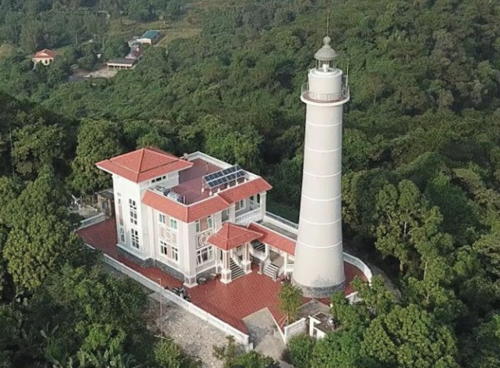
2018 (station established 1961). Active; focal plane 89 m (292 ft); two white flashes every 10 s. 26 m (85 ft) round concrete tower with lantern and gallery, rcovered with small white tiles. 2-story keeper's house. Nguyen Nam Son's 2020 drone view is at right and Quyet Kieu Duy has a closeup 2019 photo. An April 2007 closeup and another photo of the original lighthouse are available, Nguyễn Cương has a street view from the gallery, and Google has a satellite view. Cô Tô is a popular resort island about 40 km (25 mi) east of Cẩm Phả. Located on the highest point of the island. Site open; the photo suggests the lighthouse may be open for tours at some times. . ARLHS VIE-002; Admiralty F3314.8; NGA 20213.8.
Cô Tô West (Sha-Pak-Wan)
2013. Active; focal plane 12 m (39 ft); two white flashes every 5 s. 12 m (39 ft) tower painted with black and red horizontal bands. No photo available and Bing has only an indistinct satellite view. Located on a reef about 3 km (2 mi) west of the harbor of Cô Tô. Accessible only by boat. Site open, tower closed. Admiralty F3314.6.

Cẩm Phả Area Lighthouses
Cẩm Phả is a coal-exporting seaport in southern Quảng Ninh Province.

Quan Lạn
Date unknown. Active; light characteristics unknown. Approx. 24 m (79 ft) octagonal cylindrical concrete tower with gallery. Lighthouse painted (top to bottom) with green, white, red, and gold horizontal bands. T Nguyễn Đắc Vệ has a view from the sea and Google has a satellite view. Despite its name, this lighthouse is located at the southern tip of Đảo Ba Mùn, marking the narrow passage between that island and Đảo Quan Lạn. There's a good view from ferries between Cẩm Phả and Cô Tô. Accessible only by boat. Site status unknown. Not listed by the Admiralty.
* Vân Đồn (Phương Đông)
2020 (?). Active (?); focal plane about 18 m (59 ft); light characteristics unknown. Approx. 15 m (49 ft) octagonal tower with lantern and gallery, painted white with red trim. Thinh Nguyen has a 2022 photo, Mạc Xuân Dũng has a 2021 street view, and Google has a satellite view. Located on the waterfront of Vân Đồn. site open, tower closed. Not listed by the Admiralty.


Vĩnh Thực Light, Quảng Ninh, June 2020
Google Maps photo by ERAV


Cô Tô Light, Quảng Ninh, July 2020
Google Maps drone view by Nguyen Nam Son

Cẩm Phả Third Range Front
Date unknown. Active; focal plane 13 m (43 ft); continuous green light. 12 m (39 ft0 concrete or masonry tower painted with black and white horizontal bands. Khoi Tranduc has a view from the nearby Van Don 2 Bridge, Che Trung Hieu has a distant view, Dzung Nguyen has a 2022 view from the sea, and Google has a satellite view. According to NGA the rear light is on the wall of a building. Located at the south point of an island opposite the Cẩm Phả waterfront. Site status unknown. Admiralty F3314; NGA 20214.8.
Cẩm Phả Second Range Front
Date unknown. Active; focal plane 8 m (26 ft); continuous red light. 15 m (49 ft) square tower painted with black and white horizontal bands. This light is offshore in the left distance in a photo by Đức Hiệp Trần and offshore on the left in Quan Nguyen's photo, and Google has a satellite view. Located off the Cửa Ông harbor in Cẩm Phả. Accessible only by boat. Site open, tower closed. Admiralty F3313; NGA 20214.6.
Cẩm Phả Second Range Rear
Date unknown. Active; focal plane 12 m (39 ft); continuous red light. 18 m (59 ft) square tower painted with black and white horizontal bands. The light is on the left in Che Trung Hieu's photo and Google has a satellite view. Located 650 m (0.4 mi) north of the front light. Accessible only by boat. Site open, tower closed. Admiralty F3313.1; NGA 20214.7.
Cẩm Phả First Range Front
Date unknown. Active; focal plane 8 m (26 ft); continuous white light. 12 m (39 ft) square tower painted with black and white horizontal bands. No photo available but Google has a satellite view. Located about 2 km (1.2 mi) southeast of the Cửa Ông harbor in Cẩm Phả. Accessible only by boat. Site open, tower closed. Admiralty F3312; NGA 20214.4.
Cẩm Phả First Range Rear
Date unknown. Active; focal plane 12 m (39 ft); continuous white light. 16 m (52 ft) square tower painted with black and white horizontal bands. No photo available but Google has a satellite view. Located 816 m (0.5 mi) northeast of the front light. Accessible only by boat. Site open, tower closed. Admiralty F3312.1; NGA 20214.5.
Soi Đèn (Le Cancrelat)
1964. Active; focal plane 47 m (154 ft); white flash every 5 s. 13.5 m (45 ft) round cylindrical concrete tower with a large round watch room structure and gallery. Entire lighthouse is white. Wikimapia has a small photo and Google has a satellite view. This light replaced a 5 m (17 ft) tower. It marks the entrance to the Passe du Lapérouse, the channel leading to Cẩm Phả. Located on a rocky islet about 25 km (15 mi) southeast of Hạ Long (Hong Gai). Accessible only by boat. Site status unknown. ARLHS VIE-031; Admiralty F3306; NGA 20214.
Hạ Mai
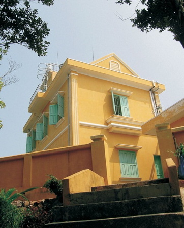
2005. Active; focal plane 181 m (594 ft); three white flashes every 10 s. 11 m (36 ft) lantern mounted on a square concrete block keeper's house, painted yellow. A VMS-North photo is at right and Google has a satellite view of the station. Hạ Mai is the southernmost island of Quảng Ninh, about 50 km (30 mi) southeast of Hạ Long (Hong Gai). Located on the southern end of the island. Accessible only by boat. Site status unknown. Admiralty F3306.5; NGA 20215.5.

Hạ Mai Light, Quảng Ninh
ex-VMS-North photo

Hạ Long Area Lighthouses
Hạ Long, the capital of Quảng Ninh Province, is a major port at the southern end of Quảng Ninh Province about 50 km (30 mi) east of Hải Phòng. Bãi Cháy is the port district of the city.

*
Bãi Cháy (Hạ Long, Hong Gai)
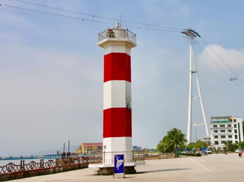
Date unknown. Active; focal plane about 17 m (56 ft); red flash every 2 s. Approx. 16 m (52 ft) hexagonal cylindrical concrete tower with gallery, painted with red and white horizontal bands. Thai Nguyen Hong posted the photo at right, Paul Tuyen has a 2007 photo, and Google has a satellite view and a street view also showing the suspension bridge that has replaced the ferry. Located on the west side of the entrance to Hạ Long Bay, near the city's tourist hotels. Site open, tower closed. Admiralty F3296; NGA 20224.
Con Chim
Date unknown. Active; focal plane 14 m (46 ft); three quick white flashes every 10 s. 9 m (30 ft0 round concrete tower painted black with one yellow horizontal band. No photo available but Google has a satellite view. Located on a reef on the west side of the channel leading to Hạ Long. Accessible only by boat. Site status unknown. Admiralty F3294.
[Hòn Bài]
2000. Active; focal plane 45 m (148 ft); four white flashes, in a 3+1 pattern, every 16 s. 3 m (10 ft) square concrete tower. Entire lighthouse is white. Google has a satellite view. Located on a rocky islet at the southeastern end of the Cát Bà islands marking the start of the approach to Hạ Long. Accessible only by boat. Site status unknown. Admiralty F3293.5.

Bãi Cháy Light, Hạ Long, posted April 2019
ex-VMS-North photo

Hải Phòng Municipality Lighthouses

Hải Phòng, the major port of northern Vietnam, is a city of more than 2 million residents. The city is built at the mouth of the Cấm River (Sông Cấm), the northermost distributary of the Red River Delta. There are two entrances from the Gulf of Tonkin, separated by the island of Cát Hải. The largest ships enter through the eastern entrance and then turn sharply through a dredged channel on the north side of Cát Hải that merges with the western entrance. For reasons unknown NGA dropped its listings of most Hải Phòng harbor lights in 2014.

Long Châu Lighthouse
Long Châu (Xuy Nong Chao, Grande Norway Island)
1894. Active; focal plane 110 m (361 ft); white flash every 4 s. 30 m (98 ft) round stone tower rising from the center of a square 2-story masonry keeper's house. The tower is unpainted gray stone; lantern painted white with a dark metallic dome. Da Lam Van's 2022 photo is at right, VMS-North has a good photo, Ngô Tất Đạt has a 2020 photo, Tài Hoàng has a 2023 photo, Khoa Vo has a drone view, and Bing has a satellite view of the station. This staffed station is the traditional landfall light for both Hải Phòng and Hạ Long. Located on the highest point of Xuy Nong (or Long) Châu, the largest of the Long Châu Islands, about 60 km (37.5 mi) southeast of Hải Phòng. Accessible only by boat. Site and tower closed. ARLHS VIE-020; Admiralty F3232; NGA 20216.

Eastern Entrance (Cát Hải Island Area) Lighthouses
Đảo Cống Range Front (Hải Phòng Approach A)
Date unknown. Active; focal plane unknown; white flash every 4 s. Square skeletal tower, painted with blue and white horizontal bands, on a platform supported by piles. Thanh Sơn has a distant view and Google has a satellite view. This the approach range for the eastern entrance to the harbor. Located northwest of Đảo Phù Long, a marshy island east of the harbor, and south of Đảo Cống, another marshy island to the north. Accessible only by boat. Site and tower closed. Admiralty F3240.
Đảo Cống Range Rear (Hải Phòng Approach B)
Date unknown. Active; focal plane and light characteristic unknown. Square skeletal tower on a platform supported by piles. No photo available but Google has a satellite view. Located off the southwest point of Đảo Cống, about 1200 m (3/4 mi) north northwest of the front light. Accessible only by boat. Site and tower closed. Admiralty F3240.1.
Phù Long Range Front (Hải Phòng Approach C)
Date unknown. Active; focal plane and light characteristic unknown. Square skeletal tower on a platform supported by piles. A very distant view is available, the light is seen at the far left in Giang Nguyen's drone view, and Google has a satellite view. The range guides departing vessels on an west-to-east cut in the entrance to the harbor. Located off the west point of Đảo Phù Long, a marshy island east of the harbor. Accessible only by boat. Site and tower closed. Admiralty F3242.
Phù Long Range Rear (Hải Phòng Approach D)
Date unknown. Active; focal plane and light characteristic unknown. Square skeletal tower on a platform supported by piles. The light is seen in the channel right of center in Giang Nguyen's drone view, and Google has a satellite view. Located about 1200 m (3/4 mi) east of the front light. Accessible only by boat. Site and tower closed. Admiralty F3242.1.

Long Châu Light, Hải Phòng, July 2022
Google Maps photo by Da Lam Van
Cửa Nam Triệu Range Front (Hải Phòng Approach E)
Date unknown. Active; focal plane and light characteristic unknown. Square skeletal tower on a platform supported by piles. No photo available but Google has a satellite view. The range guides vessels on an east-to-west cut in the entrance to the harbor. Located about 600 m (3/8 mi) north of the Đảo Cát Hải bridge. Accessible only by boat. Site and tower closed. Admiralty F3250.
Cửa Nam Triệu Range Rear (Hải Phòng Approach F)
Date unknown. Active; focal plane and light characteristic unknown. Square pyramidal skeletal tower on a platform supported by piles. No photo available but Google has a satellite view. Located about 1200 m (3/4 mi) west of the front light. Accessible only by boat. Site and tower closed. Admiralty F3250.1.

Western Entrance Lighthouses
Den Aval (Cửa Nam Triệu Bar Range Front)
Date unknown. Active; focal plane unknown; light characteristic unknown. 16 m (52 ft) tower with black and white horizontal bands. No photo available but Bing has a satellite view. This light and the next one appear to be a leading range for the western approach channel, but they are no longer classified as a range by the Admiralty. Located about 4 km (2.5 mi) southeast of the Đảo Cống harbor entrance. Accessible only by boat. Site and tower closed. Admiralty F3247.5 (ex-F3268); ex-NGA 20248.
Bai Cat (Cửa Nam Triệu Bar Range Rear)
Date unknown. Active; focal plane unknown; three white flashes every 10 s. 27 m (89 ft) square pyramidal skeletal tower mounted. A distant photo from a Google Maps street view is at right and Google also has a satellite view. Located about 1.5 km (0.9 mi) northwest of the Den Aval lighthouse. Accessible only by boat. Site and tower closed. Admiralty F3247.7 (ex-3268.1); ex-NGA 20252.

Bai Cat Light, Hải Phòng, May 2022
Google Maps street view

Inner Harbor Lighthouses
Van Châu (Song Bach Dang)
Around 2021 (station established 1900). Active; light characteristics unknown. Square skeletal tower mounted on a platform supported by piles. No photo available but Google has a satellite view. This new light replaced a skeletal tower located a short distance northwest. Located on the Nam Triệu River at the mouth of the Bach Dang River in Hải Phòng. Accessible only by boat. Site and tower closed. The new light is not listed by the Admiralty. Previous light: ARLHS VIE-040; ex-Admiralty F3280.4; ex-NGA 20264.5.
#Đình Vũ East Entrance South Side (2)
Date unknown. Removed but still listed with focal plane 11 m (36 ft); red flash every 3 s. This was a 12 m (39 ft) round barbell shaped tower. Entire lighthouse was red. An Nguyễn Hải has a 2013 photo and Dần Lê has a 2015 distant view but Lê Minh Thuận's 2020 drone view shows that the lighthouse has been removed following construction of a new bridge across the river. Google's satellite view shows the old location. NGA formerly listed a "tripod" with black and white bands. Located under the new bridge on the south side of the entrance to the Đình Vũ branch of the Red River, which leads to the inner harbor of Hải Phòng. Site status unknown. Admiralty F3267 (ex-F3279.2); NGA 20265.1.
Đình Vũ East Entrance North Side (3?)
Date unknown. Active; focal plane 11 m (36 ft); white or red light, depending on direction, 1.5 s on, 1.5 s off. 12 m (39 ft) round white cylindrical tower with a pyramidal base. This light is at the far left in Do Van Dung's photo showing the new bridge under construction, it is near the right edge of Lê Minh Thuận's 2020 drone view, and Google has a satellite view. NGA formerly listed a "red column on piles." Located on the north side of the entrance to the Đình Vũ branch of the Red River, which leads to the inner harbor of Hải Phòng. Accessible only by boat. Site status unknown. Admiralty F3268 (ex-F3279); NGA 20265.
 
Đình Vũ West Entrance North Side (2)
Date unknown. Active; focal plane 14 m (46 ft); white flash every 3 s. 14 m (46 ft) white tower on a square platform supported by piles. No photo available but Google has a satellite view. NGA formerly listed a red skeletal tower. Located on the north side of the entrance to the west branch of the river, upstream from the east entrance lights. Accessible only by boat. Site status unknown. Admiralty F3269 (ex-F3280); NGA 20265.5.

Hòn Dấu Lighthouse
** Hòn Dấu (2)
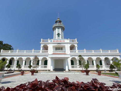
1894 (station established 1876). Active; focal plane 63.5 m (208 ft); two white flashes every 10 s. 23 m (75 ft) octagonal masonry tower with lantern and gallery, attached to a 1-story masonry keeper's house. Lighthouse painted light blue. Lantern dome is gray metallic. Thành Phan Rang's 2023 photo is at right, VMS aerial photo is available, Duc Ta Minh has a 2014 photo, Do Son Duong has a 2007 closeup photo, a second closeup is available, Lighthouse Digest has a historic photo contributed by Michel Forand, Tuan Anh has a street view from the gallery, and Google has a satellite view of the station. The original 1st order Fresnel lens has been removed from the lantern and is apparently on display under the portico. Located on a small island on the south side of the entrance to Hải Phòng, about 40 km (25 mi) southeast of the city; transportation should be available from resorts on the island. Site open, tower appears to be open. ARLHS VIE-024; Admiralty F3236; NGA 20268.

Đảo Bạch Long Vĩ (Nightingale Island) Lighthouse
Đảo Bạch Long Vĩ (Nightingale Island)
1995. Active; focal plane 80 m (262 ft); two white flashes every 10 s. 23 m (75 ft) octagonal concrete tower with lantern and gallery, centered on an octagonal 2-story keeper's house. Lighthouse painted gray with white trim, keeper's house yellow with white trim. A photo is at right, a VMS-North photo is available, a 2017 photo is available, Hiển Đoàn Văn has a 2019 photo, Huong Nguyen has more distant view, and Google has a satellite view. Bạch Long Vĩ is an isolated island in the middle of the Gulf of Tonkin, halfway between Vietnam and the Chinese island of Hainan. In 1887 China was obliged to cede control of the island (then uninhabited) to France. The island was occupied by Japanese forces during World War II and then by Nationalist Chinese forces after the war. The Nationalist troops were overcome by forces of the People's Republic in 1955, but in 1957 the Chinese government agreed to return the island to Vietnam. Late in 2000 Vietnam and China signed a treaty establishing the maritime boundary between the two countries, and this agreement confirms Vietnamese ownership of Bạch Long Vĩ. Located on the highest point of the island. Site and tower closed. ARLHS VIE-016; Admiralty F3230; NGA 20273.


Hòn Dấu Light, Hải Phòng, January 2023
Google Maps photo by Thành Phan Rang


Đảo Bạch Long Vĩ Light, Gulf of Tonkin, May 2018
Google Maps photo by Nha que

Southern Gulf of Tonkin Lighthouses

Thái Bình Province Lighthouses
* Diêm Điền
1997. Active; focal plane 27 m (89 ft); white flash every 5 s. 23 m (75 ft) round concrete tower with 8 buttresses, lantern, and gallery. Lighthouse painted gray, buttresses white. The VMS-North photo is at right, Lộc Nguyễn has a 2023 view of the lighthouse, Minh Thanh Do has an aerial view, and Google has an indistinct satellite view. Diêm Điền is a fishing port on the Gulf of Tonkin about 40 km (25 mi) south of Hải Phòng. Located on the Diêm Điền waterfront. Site probably open, tower closed. Admiralty F3235; NGA 20270.
Cửa Ba Lạt
Date unknown. Active; focal plane unknown; white flash every 4 s. No description available but the range of the light is listed as 12 nautical miles (22 km, 14 mi), implying a substantial tower. No photo available and the light is not seen in Google's satellite view. Located about 2.5 km (1.5 mi) offshore and 10 km (6 mi) north of the Ba Lạt lighthouse (next entry). Admiralty F3234; NGA 20272.
* Ba Lạt
1962. Active; focal plane 37 m (121 ft); four white flashes, in a 3+1 pattern, every 20 s. 34 m (112 ft) octagonal concrete tower with lantern and gallery, rising from the center of a 1-story keeper's house. The tower is painted gray; lantern and gallery painted white, keeper's house yellow. Vương Đinh's photo is at the top of this page, Thanh Ngân Vũ has a closeup 2020 photo, Thanh Hiền Phí has a 2022 photo, Huong Nguyen has a 2009 photo, another photo is available, and Google has a satellite view of the station. Located on an island off the mouth of the Ba Lạt River, the principal branch of the Red River, about 55 km (35 mi) south of the Hòn Dấu Light. Site open, tower status unknown. ARLHS VIE-009; Admiralty F3233; NGA 20272.5.

Diêm Điền Light, Thái Bình Province
VMS-North photo

Nam Định Province Lighthouses
Quất Lâm (2)
Date unknown (station established 1966). Active; focal plane 26 m (85 ft); white flash every 4 s. 22 m (72 ft) hexagonal cylindrical with lantern and gallery, painted with red and buff horizontal bands, rising from or adjacent to a 1-story station building. Lantern roof is gray metallic. Van Trung Pham has a 2019 photo, Loi Phong Hinh has a 2018 photo, Nguyễn Hiển has a closeup, a closeup of the lantern is available, and Google has a satellite view of the station. The former lighthouse was a square steel skeletal tower with gallery, painted gray. Quất Lâm is a fishing port about 30 km (19 mi) southeast of Nam Định city. Site status unknown. Admiralty F3229; NGA 20272.8.s
* Lạch Giang (2)
Date unknown (station established 2001). Active; focal plane 21 m (69 ft); three white flashes, in a 2+1 pattern, every 10 s. 17 m (56 ft) tapered round concrete tower with lantern and gallery. The tower is unpainted except for a red vertical stripe. Tuấn Vũ Văn's 2018 photo is at right, Minh Lee also has a photo, Nghị Trần has a closeup, and Google has a satellite view of the station. Located on the waterfront of Lạch Giang, a small port about 35 km (22 mi) south southeast of Nam Định city. Site open, tower closed. Admiralty F3228; NGA 20272.9.

Thanh Hóa Province Lighthouses
* Lạch Trào (Lạch Chào)
1965. Active; focal plane 27 m (89 ft); two white flashes every 10 s. 22 m (72 ft) octagonal concrete tower with gallery. Lighthouse painted gray, lantern yellow. 1-story keeper's houses, painted yellow. kien kythuatSX has a 2023 photo and Google has a satellite view. Lạch Trào is the seaport associated with Thanh Hóa, located about 13 km (8 mi) east of the city. Located on the north side of the estuary entrance. Site open, tower closed. Admiralty F3227.

Lạch Giang Light, Nam Định, December 2-18
Google Maps photo by Tuấn Vũ Văn
Hòn Mê (2?)
1977. Active; focal plane 154 m (505 ft); three white flashes, in a 2+1 pattern, every 15 s. 18.5 m (61 ft) round concrete tower with lantern and gallery, rising from a 1-story concrete keeper's house. Entire lighthouse painted white. Hiếu Trung has a closeup 2023 photo and Bing has a satellite view. Hòn Mê is an island about 15 km (9 mi) offshore and 25 km (15 mi) southeast of Tĩnh Gia. Located on the highest point of the island. Accessible only by boat. Site status unknown. ARLHS VIE-026; Admiralty F3225; NGA 20274.
Biển Sơn (3)
Date unknown (station established 1904). Active; focal plane 34 m (112 ft); white flash every 5 s. 14 m (46 ft) round concrete tower with lantern and gallery, painted with black and white horizontal bands. Oden Kardakov's photo is at right, Trung Hoang has a closeup photo and Bing has a fuzzy satellite view. The 1962 lighthouse was an 11.5 m (38 ft) square skeletal tower mounted on a 1-story square concrete service building. Biển Sơn is an inhabited island just off the coast opposite Hòn Mê. A causeway connects the island to the mainland. Located on the eastern side of the island, which shelters a small harbor. Site status unknown. Admiralty F3224; NGA 20275.

Nghệ An Province (Vinh Area) Lighthouses
Hòn Mát (Mui Sot)
2004. Active; focal plane 202 m (663 ft); three white flashes, in a 2+1 pattern, every 10 s. 12.5 m (41 ft) round cylindrical concrete tower with lantern and gallery. Lighthouse painted yellow with white trim. 2-story keeper's house, also painted yellow with white trim. Trần Thị Thúy Hà has a photo and Google has a fuzzy satellite view. Apparently the lantern was added around 2018. This is the landfall light for the port of Vinh, the largest city of Vietnam's north central coast. Hòn Mát is an isolated high island about 20 km (13 mi) off the coast just north of Vinh. Located on the highest point of the island. Accessible only by boat. Site status unknown. Admiralty F3219.5; NGA 20276.1.
Hòn Lò (Mui Rong, Cửa Lò)
Date unknown. Active; focal plane about 20 m (66 ft); white flash every 1.5 s. Approx. 20 m (66 ft) tower painted with black and white horizontal bands, mounted on a square pier. Quoc Nguyen has a very distant view, Thi Anh Tran also has a very distant view and Google has a satellite view. Located about 1.6 km (1 mi) off the protected harbor of Cửa Lò. Accessible only by boat. Site status unknown. Admiralty F3221.
Nghi Thiết
Date unknown. Active; focal plane about 22 m (72 ft); green light, pattern unknown. Approx. 20 m (66v ft) round concrete tower with gallery, painted green with one white horizontal band. Dương Nguyễn has a photo and Google has a satellite view. Nguyễn Tâm's distant view also shows a much older beacon. Located on a pier on the northside of the entrance to Mui Rong. Accessible only by boat. Site status unknown. Admiralty F3221.1.

Biển Sơn Light, Thanh Hóa, December 2019
Google Maps photo by Oden Kardakov
Cửa Hội (Vinh River) (2)
2015 (station established 1966). Active; focal plane 25 m (82 ft); three white flashes every 15 s. 25 m (82 ft) round cylindrical concrete tower with lantern and gallery, painted white with a narrow red vertical stripe. Anh Đức Trần has a 2016 photo, a foggy 2016 photo is available, Eden Arrizabalaga has a view from the river, and Google has a satellite view. The original light was a square skeletal tower. Located on the north side of the entrance to the Cửa Hội estuary about 12 km (7.5 mi) northeast of Vinh. Site status unknown. ARLHS VIE-043; Admiralty F3220; NGA 20276.

Hà Tĩnh Province Lighthouses
Cửa Sót (Mui Lo) (2)
Date unknown (station established 1969). Active; focal plane 90 m (295 ft); two white flashes every 6 s. 13 m (43 ft) square cylindrical concrete tower with three galleries, painted yellow with white trim. A 2023 photo is at right, Huy Hải has a photo, and Google has a distant satellite view. The present lighthouse replaced a short concrete beacon, seen to the left of the tower in the VMS-North photo and in a 2016 street view. Located on a forested headland on the south side of the entrance to the Cửa Sót estuary. Site status unknown. Admiralty F3219.3; NGA 20276.2.
Cửa Nhượng
1967. Active; focal plane 35 m (115 ft); white flash every 6 s. 15 m (49 ft) round cylindrical concrete tower with gallery, adjacent to a 1-story keeper's house. The tower is painted with red and white horizontal bands. Hoang Nguyen Dang has a 2018 photo, Thoa Kim has a closeup, Huy Hải has a view from the sea, and Google has a satellite view. Located on the south side of the entrance to the Cửa Nhượng estuary about 25 km (15 mi) southeast of Hà Tĩnh city. Site status unknown. Admiralty F3219.2; NGA 20276.3.
Mũi Ròn
1999. Active; focal plane 205 m (673 ft); four white flashes every 20 s. 16 m (52 ft) round concrete tower with an expanded upper section. Lighthouse painted gray. 2-story keeper's house painted white. A 2019 photo is available, Phuc Tran has a second photo, and Google has a satellite view. Mũi Ròn is the cape at the end of a 5 km (3 mi) long peninsula that projects suddenly into the South China Sea, forming a significant hazard to navigation. Located on the headland at the tip of the peninsula. Site status unknown. Admiralty F3219.

Cửa Sót Light, Hà Tĩnh, August 2023
Google Maps photo by HUONGMIT

Notable faux lighthouses:

Information available on lost lighthouses:

Adjoining pages: North: Southwest Guǎngxī | East: Southwestern Hainan | South: Central Vietnam

Return to the Lighthouse Directory index | Ratings key

Posted April 24, 2006. Checked and revised March 8, 2024. Lighthouses: 46. Site copyright 2024 Russ Rowlett and the University of North Carolina at Chapel Hill.