Lighthouses of South Central Vietnam

The Socialist Republic of Vietnam occupies the east coast of Mainland Southeast Asia. After being independent for many centuries Vietnam was colonized by France as part of French Indochina from the mid 1800s until 1941, when the country was invaded and conquered by Japan. After the end of World War II in 1945 French attempts to re-establish control triggered 30 years of warfare. In 1954 an armistice agreement provided for the French withdrawal but divided the country into northern and southern halves. The Vietnam War, a complex struggle between the two Vietnamese governments, was already underway in the late 1950s and escalated with U.S. intervention beginning in 1964. U.S. troops were withdrawn in 1973 and two more years of war led to the reunifucation of the country in 1975.

Vietnam is long and narrow, with a coastline measuring some 3000 km (1875 mi) in length. The northern third of the coast faces the Gulf of Tonkin (Vịnh Bắc Bộ, "Northern Bay" in Vietnamese) and the rest faces east and southeast on the open waters of the South China Sea, known as Biển Đông, "East Sea" in Vietnamese.

Vietnam is divided into 58 provinces and five province-level municipalities. This page includes the lighthouses of the southern half of the central coast, facing east on the South China Sea, from Bình Định Province through Bà Rịa–Vũng Tàu Province. From 1945 to 1975 this area was part of "South Vietnam" (the Republic of Vietnam).

Fortunately the lighthouses of Vietnam were not usually seen as targets during the Vietnam War and most of them survived the fighting without major damage. A few of the historic French lighthouses have been replaced but most remain in service and are regarded as historic monuments. In general Vietnamese lighthouses have resident keepers.

The Vietnamese words for a lighthouse are hải đăng or đèn biển ("sea light"). Dao or hòn is an island, quần đảo is an archipelago, bãi cạn is a shoal, mũi is a cape, sông is a river, cửa ("door") is the mouth of a a river, vịnh is a bay, and hải cảng is a harbor.

Aids to navigation in Vietnam are maintained by two Maritime Safety Companies, Vietnam Maritime Safety - North (VMS-North) maintaining lights in the northern half of the country and Southern Vietnam Maritime Safety (VMS-South) maintaining the lights of the southern half. All the lights on this page are maintained by VMS-South.

ARLHS numbers are from the ARLHS World List of Lights. Admiralty numbers are from volume F of the Admiralty List of Lights & Fog Signals. U.S. NGA List numbers are from Publication 112.

General Sources
Southern Vietnam Maritime Safety - Lighthouses
An interactive map of lighthouse locations, linking to pages on the individual light stations.
World of Lighthouses - Vietnam
Photos by various photographers available from Lightphotos.net.
Online List of Lights - Vietnam - South China Sea
Photos by various photographers posted by Alexander Trabas.
List of AtoN System
Light data published by SVMS in 2016.
Leuchttürme Asiens auf historischen Postkarten
Historic postcard images posted by Klaus Huelse.
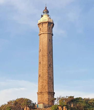

Kê Gà Light, Bình Thuận, October 2019
Google Maps photo by Tuan Nguyen Hoang

Bình Định Province (Qui Nhơn Are) Lighthouses
Hòn Nước
1997. Active; focal plane about 72 m (236 ft); white flash every 5 s. Approx. 22 m (72 ft) round cylindrical white concrete tower with lantern and gallery. 1-story keeper's house painted white. Nhà ở và Du Lịch has a 2022 photo, Quán Lê Văn has a 2023 closeup, Lưu Văn Cam has a February 2018 photo, and Google has a satellite view of the station. The lantern was added when the lighthouse was restored in 2017. Dan Baldini has a January 2016 photo of the original appearance of the lighthouse. Located on a promontory at Xuân Thành about 60 km (37 mi) north northeast of Qui Nhơn. Site status unknown; may be accessible by a short walk from Xuân Thành. Admiralty F3177.
Phước Mai (Qui Nhơn ) (2?)
1975 (station established 1904). Active; focal plane 54 m (177 ft); three white flashes, in a 2+1 pattern, every 15 s. 8 m (26 ft) round white concrete tower with gallery. Thanh Phuong Nguyen has a 2020 closeup photo, Nguyen Thanh Thi has a 2018 photo, Ngoc Minh Hoang has a view of the station, a 2007 photo of the top of the tower is available, and Google has a satellite view. VSMS lists 1975 as the date of this lighthouse but the modern light may be a refurbishment of the 1904 French tower. Located at the end of the Phước Mai peninsula, which shelters the harbor of Qui Nhơn (Quy Nhon). Site status unknown. ARLHS VIE-047; Admiralty F3162; NGA 20332.
Qui Nhơn Fairway Range Front
Date unknown. Active; focal plane 10 m (33 ft); three white flashes every 10 s. 10 m (33 ft) round tower with a large circular gallery, colored with red and white horizontal bands and mounted on a circular pier. Huyen Trang has a distant 2022 view, Dũng Trần has a very distant street view from shore, and Google has a satellite view. Located about 400 m (1/4 mi) offshore south of the rear light (next entry). Site open, tower closed. Admiralty F3162.05.
* Qui Nhơn Fairway Range Rear
Date unknown. Active; focal plane 17 m (56 ft); three white flashes every 10 s. 17 m (56 ft) triangular skeletal tower colored with red and white horizontal bands and carrying a diamond-shaped daymark. Dan Baldini has a closeup photo, Dũng Trần has a 2023 street view, and Google has a satellite view. Located beside Xuân Diệu Street on the waterfront of Qui Nhơn. Site open, tower closed. Admiralty F3162.051.
Cù Lao Xanh (Phuoc Chau, Poulo Gambir)
1904. Active; focal plane 119 m (390 ft); four white flashes, in a 3+1 pattern, every 15 s. 17 m (56 ft) round stone tower with lantern and double gallery, painted white with one black horizontal band. Nam Nguyễn's 2020 closeup is at right, Nguyễn Phạm Song Thương has a photo, a 2007 photo is available, Ton That Duy Quang has a 2019 view, Quoc Nam Alex has a distant street view, and Google has a satellite view. The lighthouse was renovated in 1984.One Vietnamese source gives 1890 as the establishment date for this station, but all other sources have 1904. Located at the highest point of an island about 10 km (6 mi) off the coast and 20 km (13 mi) southeast of Qui Nhơn. Accessible only by boat. Site open, tower status unknown. . ARLHS VIE-012; Admiralty F3158; NGA 20364.

Cù Lao Xanh (Poulo Gambir) Light, Bình Định, July 2020
Google Maps photo by Nam Nguyễn

Phú Yên Province Lighthouses
* Gành Đèn
2002. Active; focal plane 22.5 m (74 ft); white flash every 5 s. 10 m (33 ft) hexagonal cylindrical concrete tower with gallery, painted with red and white horizontal bands. Tuong Van has a closeup photo, Võ Văn Tịnh also has a photo, Long Đỗ has a 2020 photo, Khánh Nguyễn has a street view, and Google has a satellite view. Located on a rocky promontory about 10 km (6 mi) northeast of Chí Thành. Site open, tower closed. . Admiralty F3156.
* Đà Rằng (Tuy Hòa)
Date unknown. Active; focal plane 20.5 m (67 ft); two white flashes every 6 s. 17 m (56 ft) square cylindrical tower with gallery, centered on a 2-story keeper's house. Lighthouse painted white; keeper's house painted yellow with white trim. Dan Baldini has a closeup 2016 photo and Google has a satellite view. Located on the north side of the entrance to Tuy Hòa, the capital of Phú Yên province. Site open, tower may also be open. Admiralty F3155.8
*** Mũi Đại Lãnh (Mũi Điện, Cap Varella) (2)
1904 (station established 1890). Active; focal plane 110 m (361 ft); three white flashes every 15 s. 26.5 m (87 ft) round stone tower with lantern and gallery. Lighthouse painted white, lantern dome black. Khanh Do's 2020 photo is at right, a 2018 photo and a 2007 photo are available, Hà Phạm Duy has another 2007 photo, a 2024 drone view is available, Trịnh Xuân Trinh has a street view, and Google has a satellite view. The original tower had a focal plane height of only 14 m (46 ft). The present lighthouse was renovated in 1997 and appears to be in excellent condition. The light station buildings appear to include a visitor center and/or museum. Mũi Điện Lãnh (Cap Varella) is the easternmost point of the Vietnamese coast. Located on the point of the cape, about 40 km (25 mi) south southeast of Tuy Hòa. Accessible by road. Site and tower open; Erik Bjers has a street view taken from the gallery. . ARLHS VIE-011; Admiralty F3154; NGA 20368.

Khánh Hòa Province Lighthouses
Hòn Nưa
2002. Active; focal plane 87.5 m (287 ft); four white flashes every 15 s. 10 m (33 ft) hexagonal cylindrical concrete tower with gallery, painted red. Nguyễn Anh Nhật has a closeup photo, a 2019 closeup is available and Google has a satellite view. A sibling of the Gành Đèn light. Located atop an island about 13 km (8 mi) southwest of Mũi Điện. Accessible only by boat. Site status unknown. Admiralty F3151.
Hòn Đỏ Range Front (Beacon A)
2021. Active; focal plane 58 m (190 ft); three white flashes every 10 s. Approx. 15 m (49 ft) square white skeletal tower. No photo available but Google has a satellite view. This range guides ships into a deep but narrow channel on the east side of Vân Phong Bay. Located on an island in the eastern basin of the bay. Accessible only by boat. Site status unknown. Admiralty F3153.4.

Mũi Đại Lãnh (Cap Varella) Light, Phú Yên, June 2020
Google Maps photo by Khanh Do
Hòn Đỏ Range Rear (Beacon B)
2021. Active; focal plane 81 m (266 ft); three white flashes every 10 s. Approx. 15 m (49 ft) square white skeletal tower. No photo available but Google has a satellite view. Located on a forested peninsula of the mainland 1.4 km (0.87 mi) north northwest of the front light. Site status unknown. Admiralty F3153.5.
Hòn Đỏ (Hòn Hèo, Hòn Theo)
1997. Active; focal plane 81 m (266 ft); two white flashes every 10 s. 11.5 m (38 ft) round cylindrical concrete tower. Huy Hồ has a 2020 photo and Google has a satellite view of the station. Located on Hòn Đỏ, an island in the entrance to the bay of Văn Phong, about 30 km (19 mi) northeast of Nha Trang. Accessible only by boat. Site status unknown. Admiralty F3152.
*** Mũi Chụt (Bao Đai, Nha Trang)
Date unknown. Active; focal plane 42 m (138 ft); continuous white light. 15 m (49 ft) short white skeletal tower atop a hexagonal masonry tower with gallery rising from a 2-story building. Lighthouse painted a light cream color. Thi Pham posted the 2018 photo at right, Trabas has Jim Smith's 2012 photo, and Google has a closeup street view and a satellite view. The building, known as Bao Đai, was originally a villa owned by the royal family of Vietnam. It appears to be open as a museum. Located on a promontory at the south end of Nha Trang, marking the passage between the mainland and the island of Hòn Lớn (Hòn Tre). Site and building open, tower closed. ARLHS VIE-033; Admiralty F3150; NGA 20376.
Hòn Lớn (Mũi Rach Trang, Hòn Tre)
1890. Active; focal plane 102 m (335 ft); three white flashes every 10 s. 16 m (52 ft) round masonry tower with lantern and gallery, painted with black and white horizontal bands and standing in front of a keeper's house. Vohungx Cao has a closeup photo, Son Hai has a 2018 photo, a 2024 closeup is available, Ngoc Minh Hoang has a photo of the lantern, Trabas has Jim Smith's distant view, and Google has a satellite view. The island of Hòn Lớn is being developed as a beach resort but it's not clear if visitors will have access to the lighthouse. Located at Mũi (cape) Rach Trang, the eastern point of the island of Hòn Lớn, about 16 km (10 mi) southeast of Nha Trang. Accessible only by boat. Site status unknown. ARLHS VIE-029; Admiralty F3148; NGA 20372.
 

Mũi Chụt Light, Khành Hóa, October 2018
ex-Google Maps photo by Thi Pham
 
Ba Ngòi (Vịnh Cam Ranh, Cam Ranh Bay) (2)
2003 (station establishment date unknown). Active; focal plane 89.5 m (294 ft); three white flashes, in a 2+1 pattern, every 7 s. 9 m (30 ft) square tower mounted on a round masonry tower attached to the front of a keeper's house. Entire lighthouse painted beige. The VMS-South page has a closeup photo and Google has a satellite view. The original lighthouse was damaged beyond repair during the Vietnam War; a 1967 photo posted by Thắng Nguyễn Xuânis shows a closeup of the damage. The magnificent elliptical harbor of Cam Ranh Bay is entered through a narrow strait between two high, forested peninsulas. This lighthouse is located atop the headland on the north side of the entrance. Site status unknown. Admiralty F3136.
Pointe Bai-Sau (?)
Date unknown. Active(?); focal plane 8.5 m (28 ft); red flash every 4 s. 7.5 m (25 ft) round conical stone tower painted with black and white horizontal bands. The lighthouse is seen in a historic photo from 1969-70 posted by Thắng Nguyễn Xuân but it is not seen in Google's satellite view of the area. Located on a sandy point adjacent to the Cam Ranh airstrip, an important U.S. base during the Vietnam War. Site status unknown. Admiralty F3138; NGA 20388.
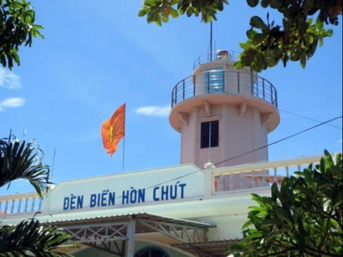
*** Hòn Chút (Bình Hưng) (2)
1988 (station established 1907). Active; focal plane 59 m (194 ft); white flash every 5 s. 16 m (52 ft) octagonal cylindrical masonry tower with gallery, rising from a 1- or 2-story keeper's house. Lighthouse painted gray, keeper's house white. Thành Phan Rang's 2023 photo is at right, Thong Tmthong has a photo, Lê Mai Ngọc has a closeup, Thai Nguyen An Minh has a distant street view, and Google has a satellite view. Located at the northeastern tip of Hòn Chút (Little Island, an island on the south side of the entrance to Cam Ranh Bay. Site and tower open. . ARLHS VIE-023; Admiralty F3134; NGA 20384.

Hòn Chút Light, Khành Hóa, January 2023
ex-Google Maps photo by Thành Phan Rang

Nình Thuận Province Lighthouse
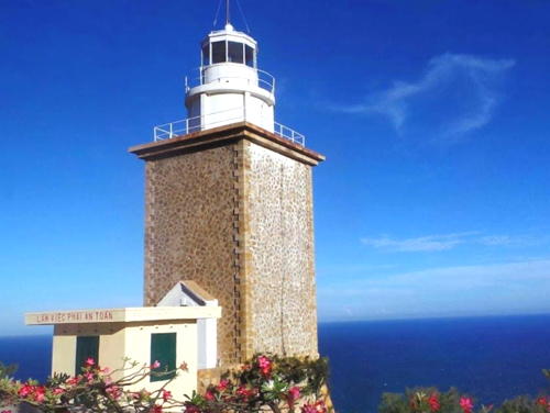
Mũi Dinh (Cà Ná, Cap Padaran) (2)
1904 (station established 1889). Active; focal plane 186 m (610 ft); three white flashes, in a 2+1 pattern, every 16 s. 16 m (52 ft) square cylindrical granite tower with lantern and gallery. The lighthouse was formerly painted white, but it appears that the paint on the tower has worn away and will not be replaced; the lantern and gallery are still painted white. A 2024 photo is at right, Thằng Hề Khóc has a 2018 photo, Đời Sống also has a closeup, Quan Le Phuong Quy has a 2021 photo, and Google has a street view and a satellite view. Located on the point of Mũi Dinh, a prominent cape near the southern end of the Central Highlands, about 40 km (25 mi) south of Phan Rang. Site status unknown. . ARLHS VIE-034; Admiralty F3122; NGA 20404.

Bình Thuận Province Lighthouses
* Phan Rí
2004. Active; focal plane 19 m (62 ft); four white flashes every 10 s. 16 m (52 ft) 4-story building with the light mounted on the roof. Lighthouse painted a dark orange-yellow with green trim. The VMS-South page has a closeup photo, a distant drone view is available, and Google has a satellite view. This lighthouse marks the entrance to the harbor of Bắc Bình. Located on the east side of the mouth of the Phan Rí river. Site status unknown, probably open; tower closed. Admiralty F3121.
* Phan Thiết (Cà Ty) (2)
2000. Active; focal plane 15 m (49 ft); three white flashes every 10 s. 10 m (33 ft) round cylindrical concrete tower with gallery. The concrete is colored with red and white horizontal bands. 2-story keeper's house painted light green with darker green trim. Trabas has Köhler's 2008 photo, Hữu Phát Nguyễn has a 2020 closeup, Huy Trung has a 2023 photo, and Google has a satellite view. This lighthouse replaces the original light, a short metal tower that had a 20 m (66 ft) focal plane. Located on a sand spit that encloses the east side of the harbor of Phan Thiết. The site appears open; tower closed. Admiralty F3117.

Mũi Dinh Light, Nình Thuận, June 2024
Google Maps photo by Support DZFullStack
** Kê Gà (Mui Ke Ga)
1900. Active; focal plane 65 m (213 ft); four white flashes, in a 3+1 pattern, every 20 s. 41 m (135 ft) octagonal granite tower with lantern and gallery. Vietnam's second tallest lighthouse. Tuan Nguyen Hoang's 2019 photo is at the top of this page, Stephan Knopf's 2013 photo, there's a good 2007 photo, Trabas has Köhler's photo, Tấn Tài Cao has a 2022 closeup, Ivan Osoff has a drone view, Phạm Việt Hùng has a closeup street view, and Google has a satellite view. This historic tower was renovated in 1975. Located on an island off the point of Mũi Kê Gà, a prominent cape about 40 km (25 mi) south southwest of Phan Thiết. Boat transportation to the island is available. Site open; the keepers offer tours of the tower. . ARLHS VIE-030; Admiralty F3116; NGA 20412.
Phú Quý
1997. Active; focal plane 124 m (407 ft); two white flashes every 15 s. 20 m (66 ft) square cylindrical concrete tower with lantern and gallery. 2-story concrete keeper's house. As of 2023 the tower is painted black; the lantern and keeper's house are painted yellow with white trim; lantern roof is gray metallic. Anh Vu's photo is at right Hoai Luong has a 2021 photo, Thanh Tin Le has a 2017 drone view, Cam Lưu Văn has a closeup, another photo is available, and Google has a satellite view. Phú Quý is a volcanic island in the South China Sea 120 km (75 mi) southeast of Phan Thiết. The island has a population of 20,000 and is the base of a fishing fleet. The Bình Thuận province government is also developing the island as a resort, and the lighthouse is mentioned as one of the attractions. Transportation to the island from Phan Thiết is available. Located on the slope of Mount Câm, near the northwestern corner of the island. Site presumably open; tower status unknown. ARLHS VIE-046; Admiralty F3120; NGA 20406.
Triều Dương
2001. Active; focal plane 11.5 m (38 ft); four white flashes, in a 3+1 pattern, every 12 s. 10 m (33 ft) concrete tower painted with red and white horizontal bands. Ngu Tam has a 2018 photo and Google has a satellite view. Nhựt Trịnh Minh has a photo of two similar but smaller lights at the ends of the nearby breakwaters. Located on a reef off the southern tip of Phú Quý island, just outside the east breakwater of the harbor. Accessible only by boat. Site open, tower closed. Admiralty F3120.5.
Hòn Hải (Poulo Sapate)
2004. Active; focal plane 122 m (400 ft); three white flashes, in a 2+1 pattern, every 10 s. 10.5 m (34 ft) hexagonal concrete tower with lantern and double gallery. Lê Phú Linh has a closeup photo and a distant view frrom the sea and Do Van Tuan has a 2020 photo, but Google's satellite view lacks detail on the islet. The lantern has been raised above the level of the original gallery. Located atop a small but spectacularly steep island about 65 km (40 mi) south of Phú Quý. Accessible only by boat. Site status unknown. Admiralty F3120.7.


Phú Quý Light, Bình Thuận Province, March 2023
Google Maps photo by Anh Vu


Bà Rịa–Vũng Tàu Province Lighthouses
Vũng Tàu is a seaport with a population of more than half a million, located on a narrow peninsula east of the entrance to the Saigon River (Sông Sài Gòn) and Hồ Chí Minh City. The port is an important base for oil drilling operations in the South China Sea.

Ba Kiềm
2006. Active; focal plane 87 m (285 ft); three green flashes every 10 s. 12.5 m (41 ft) square tower with lantern and gallery centered on a 2-story building. Lighthouse painted white (formerly yellow with white trim) and with blue shutters. Thanh Lam Nguyen has a photo, Trung Trần has a 2022 photo, and Google has a satellite view of the station. Located on heights above a cape about 50 km (30 mi) northeast of Vũng Tàu. Site status unknown. Admiralty F3115.
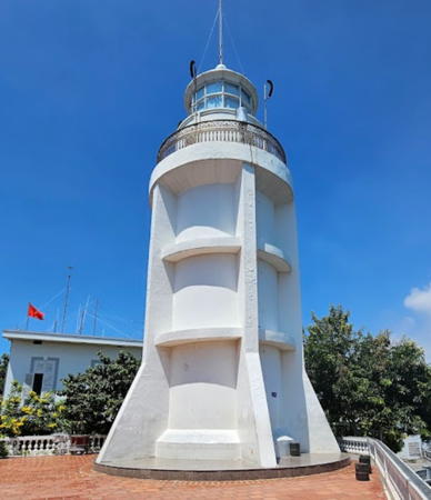
**** Vũng Tàu (Cap St.-Jacques) (3)
1913 (station established 1865). Active; focal plane 193 m (633 ft); two white flashes every 12 s. 18 m (59 ft) round cylindrical tower with lantern and gallery, surrounded by four massive concrete buttresses. A rotating Fresnel lens is in use. Entire lighthouse painted white. Arash Archer's 2023 photo is at right, Wikimedia has a closeup 2012 photo, Chung Lam Ngoc also has a closeup, Trabas has Eckhard Meyer's closeup photo, Nguyên Nguyên has a 2021 photo, Phương Trần Minh has a street view, and Google has a satellite view. This important lighthouse is the landfall light for Hồ Chí Minh City (Saigon). Huelse has historic postcard views of the 1885 lighthouse, a short octagonal masonry tower with a first order lantern and gallery, and of the 1913 lighthouse in its original form. The lighthouse was repainted all white in the spring of 2007 with the results shown in a July photo. The setting of the lighthouse is quite spectacular, with a sweeping view of the South China Sea. Located on Hải Dăng (Lighthouse) Mountain on the point of Mũi Vũng Tàu, about 8 km (5 mi) south of the town of Vũng Tàu. Site open, tower open daily. . ARLHS VIE-041; Admiralty F3066; NGA 20416.
Cao Da
Date unknown. Active; focal plane about 12 m (39 ft); green light, pattern unknown. Approx. 12 m (39 ft) round barbell-shaped tower colored with green and white horizontal bands and mounted on a square platform supported by piles. Trabas has Jim Smith's photo, aa 2024 photo is available, and Google has a satellite view and a very distant street view. Located off the west end of the Vũng Tàu peninsula. Accessible only by boat. Site open, tower closed. Admiralty F3066.2.
* Cao Trang (2)
2007 (station established 1898). Active; focal plane 20 m (66 ft); three green flashes every 12 s. 8 m (26 ft) hexagonal tower with lantern and gallery, painted white with blue trim. Trabas has Eckhard Meyer's closeup photo, Lê Minh Chánh has a photo, Janie Lin has a 2023 sunset photo, and Google has a street view and a satellite view. The 1898 tower was square. Located on the shore on the west side of the Vũng Tàu peninsula, about 6 km (4 mi) north of the Vũng Tàu lighthouse. The coastal road passes close by the lighthouse, although there is no parking turnout. Site open, tower closed. ARLHS VIE-035; Admiralty F3070; NGA 20428.
* Ghành Rái (Ganh Rai)
Date unknown (station established 1911). Active; focal plane 19 m (62 ft); two green flashes every 4 s. 14 m (46 ft) hexagonal cylindrical concrete tower with gallery but no lantern. Lighthouse painted with dark green and white horizontal bands (described as black and white by NGA). Lê Minh Chánh has a photo, Thắng Nguyên Xuân has a 2008 photo, a 2006 photo is available, and Google has a street view and a satellite view. This lighthouse guides ships into the harbor of Vũng Tàu city. The coastal road passes close by the lighthouse, although there is no parking turnout. Located at the northwestern point of the Vũng Tàu peninsula. Site open, tower closed. ARLHS VIE-049; Admiralty F3076; NGA 20432.


Vũng Tàu Light, Bà Rịa–Vũng Tàu, October 2023
Google Maps photo by Arash Archer

Vũng Tàu Inner Harbour Range Front
Date unknown. Active; focal plane about 12 m (39 ft); quick-flashing white light. Approx. 12 m (39 ft) square skeletal tower painted with red and white horizontal bands. No photo available but Google has a satellite view. Located off the waterfront of Vũng Tàu harbor. Accessible only by boat. Site open, tower closed. Admiralty F3078; NGA 20436.
Vũng Tàu Inner Harbour Range Rear
Date unknown. Active; focal plane about 20 m (66 ft); quick-flashing white light. Approx. 20 m (66 ft) square skeletal tower painted with red and white horizontal bands. No photo available but Google has a satellite view. Located 997 m (0.6 mi) east of the front light. Accessible only by boat. Site open, tower closed. Admiralty F3078.1; NGA 20440.

Information available on lost lighthouses:

Notable faux lighthouses:

Adjoining pages: North: North Central Vietnam | East: Southern Spratly Islands | South: Southeastern Vietnam

Return to the Lighthouse Directory index | Ratings key

Posted April 24, 2006. Checked and revised April 21, 2025. Lighthouses: 31. Site copyright 2025 Russ Rowlett and the University of North Carolina at Chapel Hill.