Though the landings on Guadalcanal took the great majority of the ships and Marines of the Operation "Watchtower" invasion force, the assault on the small Japanese-held islands to the north produced by far the heaviest fighting. Tulagi, site of the British Solomon Islands' pre-war government center, and the nearby Tanambogo-Gavutu seaplane base were garrisoned by tough Japanese Special Naval Landing Force troops. Tulagi, about two miles long and several hundred yards wide, held about five hundred of the enemy. U.S. Marines came ashore at 8AM on the island's undefended southwestern shore. Forming a battle line across the island, they then drove eastward toward the entrenched Japanese, who were bombarded by light cruiser San Juan, destroyers Buchanan and Monssen, plus planes from the aircraft carriers.
By the end of August 7th, the greatly-outnumbered enemy had been driven into a Tulagi's southeastern corner. Following a night of intense counterattacks, and the next day's addition of reinforcements from the Guadalcanal side of the operation, the Marines seized the rest of the island, though it took some days to eliminate the last of the defenders. This battle took the lives of about 45 Marines, while only a few of Tulagi's Japanese survived.
In the months after its capture, Tulagi was developed as a minor Naval facility. The sheltered waters near the island provided a relatively safe haven where battle-damaged warships could receive first-aid and others could be resupplied. Short-ranged motor torpedo boats, which proved themselves important during both the Guadalcanal fighting and the Central Solomons Campaign that followed in 1943, were based there, while numerous other combat support and recreational facilities ultimately were established on or close to Tulagi.
This page features, and provides links to, all our views
of the conquest of Tulagi, during the first part of the Guadalcanal
Campaign.
For more pictures related to the conquest of Tulagi, see:
For other views related to the initial phase of the Guadalcanal
Campaign, see:
| If you want higher resolution reproductions than the Online Library's digital images, see: "How to Obtain Photographic Reproductions." |
Click on the small photograph to prompt a larger view of the same image.
|
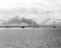
Photo #: 80-G-13539 Guadalcanal-Tulagi Operation, August 1942 A U.S. destroyer steams up what later became known as "Iron Bottom Sound", the body of water between Guadalcanal and Tulagi, during landings on both islands, 7 August 1942. Savo Island is in the center distance and Cape Esperance, on Guadalcanal, is at the left. Photographed from USS San Juan (CL-54) from a location approximately due east from the northern tip of Savo Island. Official U.S. Navy Photograph, now in the collections of the National Archives. Online Image: 114KB; 740 x 600 pixels Reproductions of this image may also be available through the National Archives photographic reproduction system. |
 |
|
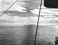
Photo #: NH 97761 Florida Island, Solomon Islands Photograph taken on 7 August 1942, the day U.S. Marines landed to capture nearby Tulagi Island. The original photo's caption states that this is the "Southwest end of Florida Island." The destroyer in the center is either USS Ellet (DD-398) or USS Wilson (DD-408). The original photograph came from the illustrations package for Rear Admiral Samuel Eliot Morison "History of United States Naval Operations in World War II", volume IV (originally published opposite page 255). U.S. Naval Historical Center Photograph. Online Image: 97KB; 740 x 630 pixels |
 |
|
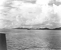
Photo #: 80-G-13485 Guadalcanal-Tulagi Invasion, August 1942 HMAS Canberra underway off Tulagi, during the landings there, 7-8 August 1942. Three transports are among the ships visible in the distance, with Tulagi and Florida Islands beyond. Official U.S. Navy Photograph, now in the collections of the National Archives. Online Image: 97KB; 740 x 615 pixels Reproductions of this image may also be available through the National Archives photographic reproduction system. |
 |
|
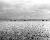
Photo #: 80-G-34676 Guadalcanal-Tulagi Operation, 7-9 August 1942 Transports and destroyers off Tulagi during the landings there, circa 7-8 August 1942. Photographed from USS Chicago (CA-29). Official U.S. Navy Photograph, now in the collections of the National Archives. Online Image: 96KB; 740 x 610 pixels Reproductions of this image may also be available through the National Archives photographic reproduction system. |
 |
|
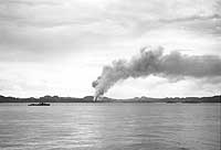
Photo #: NH 97740 Guadalcanal-Tulagi Operation, August 1942 Smoke rises from Tulagi after bombing by U.S. carrier aircraft on 7 August 1942, the day U.S. Marines landed to capture the island. The destroyer at left is either USS Ellet (DD-398) or USS Wilson (DD-408). The original photograph came from Rear Admiral Samuel Eliot Morison's World War II history project working files. U.S. Naval Historical Center Photograph. Online Image: 54KB; 740 x 530 pixels |
 |
|
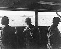
Photo #: 80-G-31372 Guadalcanal-Tulagi Operation, 7-9 August 1942 Brigadier General William H. Rupertus, USMC, (center) on board USS Neville (AP-16) during the landings on Tulagi, circa 7-8 August 1942. BGen. Rupertus, Assistant Division Commander of the First Marine Division, was in charge of combat operations on Tulagi and the other nearby Japanese-held islands. Note landing craft moving past in the background. The destroyer in the center distance is probably USS Buchanan (DD-484). Official U.S. Navy Photograph, now in the collections of the National Archives. Online Image: 84KB; 740 x 615 pixels Reproductions of this image may also be available through the National Archives photographic reproduction system. |
 |
|
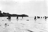
Photo #: 80-G-16485 Guadalcanal-Tulagi Operation, 7-9 August 1942 U.S. Marines come ashore on Tulagi Island, probably during the landings there on 7-8 August 1942. Official U.S. Navy Photograph, now in the collections of the National Archives. Online Image: 69KB; 740 x 530 pixels Reproductions of this image may also be available through the National Archives photographic reproduction system. |
 |
|
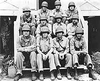
Photo #: NH 97754 "Marine Officers on Tulagi" "Here are some of the officers directing U.S. fighting against the Japanese on tiny Tulagi Island in the Solomons. Tulagi lies off Florida Island and is important for its harbor facilities. Seated on the steps of the staff house are, left to right, front row: Lieut. Colonel O.K. Pressley, Colonel M.A. Edson, Lieut. Col. H.E. Rosecrans, and Lieut. Colonel R.E. Hill, all USMC. Second row: Lieut. E.B. McLarney (MC) USN and Brig. General W.H. Rupertus, Colonel R.C. Kilmartin, Major William Enright, all USMC. Third row: Captains Ralph Powell, Daryle Seeley and Thomas Philpott, USMC." Quoted text is from the original picture's caption, which is dated October 28, 1942. The photograph was probably taken soon after the Marines captured Tulagi in August 1942. The original photograph came from Rear Admiral Samuel Eliot Morison's World War II history project working files. Official U.S. Marine Corps Photograph, from the collections of the Naval Historical Center. Online Image: 143KB; 740 x 620 pixels |
 |
|
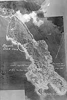
Photo #: NH 97764 Tulagi Island, Solomon Islands Annotated vertical aerial photograph, prepared for planning purposes shortly before the island was captured by U.S. Marines on 7-8 August 1942. "Beach Blue" was the Marine landing area during that operation. The original photograph came from the illustrations package for Rear Admiral Samuel Eliot Morison "History of United States Naval Operations in World War II", volume IV (originally published opposite page 288). U.S. Naval Historical Center Photograph. Online Image: 114KB; 490 x 765 pixels |
 |
For more pictures related to the conquest of Tulagi, see:
For other views related to the initial phase of the Guadalcanal
Campaign, see:
| If you want higher resolution reproductions than the Online Library's digital images, see: "How to Obtain Photographic Reproductions." |
Page made 26 January 2002