|
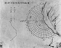
Photo #: 80-G-3914 Japanese Chart of Lahaina Anchorage, Maui, Hawaii Recovered from a Japanese Navy aircraft downed during the attack on Pearl Harbor, 7 December 1941. The chart identifies ship mooring locations and is entitled (at upper left): "Report on positions of enemy fleet at anchorage B". The chart identifies mooring locations with a radial grid. Sectors and distances are coded by single katakana figures. Official U.S. Navy Photograph, now in the collections of the National Archives. Online Image: 128KB; 740 x 605 pixels Reproductions of this image may also be available through the National Archives photographic reproduction system. |
 |
Click on the small photograph to prompt a larger view of the same image.
If you want higher resolution reproductions than this digital image, see: "How to Obtain Photographic Reproductions."
3 October 2000