|
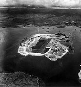
Photo #: 80-G-279375 Pearl Harbor, Oahu, Hawaii Aerial photograph of Ford Island, looking about NNE, taken 10 October 1941. The Naval Air Station occupies most of the island, with the seaplane base on the point at the near right. There are about twenty PBY patrol planes parked there. USS Enterprise (CV-6), USS Curtiss (AV-4) and two battleships are tied up along Ford Island's southeastern side, to the right. The bright line, just above Ford Island in the center, points to the north. Aiea is on the far shore in the upper right. Official U.S. Navy Photograph, now in the collections of the National Archives. Online Image: 99KB; 600 x 675 pixels Reproductions of this image may also be available through the National Archives photographic reproduction system. |
 |
Click on the small photograph to prompt a larger view of the same image.
If you want higher resolution reproductions than this digital image, see: "How to Obtain Photographic Reproductions."
5 October 2000