|
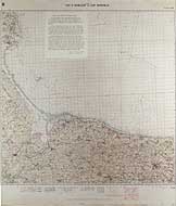
Photo #: NH 89474-KN (color) Normandy Invasion, June 1944 Chart of the invasion area used by USS Texas (BB-35) during her bombardments in support of the landings on 6 June 1944. "Utah" Beach is at left, with "Omaha" Beach along the lower shoreline. Parallel lines in the chart's upper right section mark channels swept for enemy mines. The text in the upper left center is provided in Photo # NH 89474-KN (extended caption). Donation of Captain R.B. Derickson, USN (Retired), who was Texas' Gunnery Officer during the invasion. U.S. Naval Historical Center Photograph. Online Image: 303KB; 1025 x 1225 pixels |
 |
Click on the small photograph to prompt a larger view of the same image.
If you want higher resolution reproductions than this digital image, see: "How to Obtain Photographic Reproductions."
18 December 2003