Photo #: NH 104139
Iwo Jima, Volcano Islands
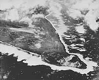
"'Tip' The Marines will Take: Southwest Promontory of Iwo
Jima -- Taken during an earlier aerial strike by Navy carrier-based
planes, this aerial photograph of strategic Iwo Jima reveals
the southwest tip of the island, with the cratered height of
Mount Suribachi at the far end of Tobiishi Point. Announcement
was made today that members of the Marines' Fifth Amphibious
Corps have swarmed ashore and opened the battle for the base
following an obliterating preliminary barrage by hundreds of
Navy ships and planes." Quoted from the original caption,
released with this photograph on 19 February 1945.
The view looks approximately east, with Mount Suribachi in the
lower right. Bombs are bursting at the southern end of Airfield
Number One, in the left center. Note the agricultural fields
between the camera and the airfield.
Heavy surf all around the island indicates particularly bad weather
on this day.
The original print came from Rear Admiral Samuel Eliot Morison's
World War II history project working files.
Official U.S. Navy Photograph, from the collections of the
Naval Historical Center.
Online Image: 89KB; 740 x 625 pixels |
 |