|
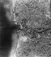
Photo #: NH 104963 Mouth of the Bishi River, Okinawa Vertical photograph, possibly taken taken during the 10 October 1944 carrier raids on Okinawa, or perhaps later in 1944 or early in 1945. It shows approximately one nautical mile of western Okinawa shoreline, centered on the Bishi River's mouth. During the April 1945 invasion of Okinawa, this region encompassed landing beaches Yellow 1 (at top) through Purple 2 (at bottom). See Photo # NH 104962 (complete caption) for a comprehensive oblique view that includes this area, with Photo # NH 104962-G showing much the same coastline as in this image, seen from offshore. Donation of Joan Louise Diamond, 2007, from the collection of her father, Lieutenant Commander David M. Diamond, USNR, who served in USS Renville (APA-227) during the Okinawa Campaign. U.S. Naval Historical Center Photograph. Online Image: 119KB; 665 x 765 pixels |
 |
Click on the small photograph to prompt a larger view of the same image.
If you want higher resolution reproductions than this digital image, see: "How to Obtain Photographic Reproductions."
Image posted 1 September 2007