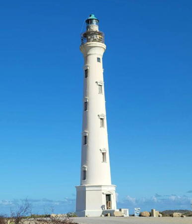
Aruba is an island in the southern Caribbean Sea located only 27 km (17 mi) from the coast of Venezuela. It is the westernmost of the so-called ABC Islands (Aruba, Bonaire, and Curaçao). A popular destination for cruise ships and vacationers, the island is 32 km (20 mi) long and has a population of about 110,000. Aruba has been a Dutch colony since 1636. From 1815 to 1954 Aruba was part of the colony of Curaçao and Dependencies; it then joined the the Netherlands Antilles, a federation of the Dutch territories in the West Indies. It left that federation in 1986 and has been a separate self-governing country (Land Aruba in Dutch) of the Netherlands since then. It is a popular tourist destination and one of its best known historical attractions is the "California" lighthouse seen at right.
Dutch is the official language in Aruba although a Portuguese-based creole language called Papiamento is commonly spoken. In Dutch vuurtoren is a lighthouse, lichtopstand is a smaller light beacon, baken is an unlit beacon, eiland is an island, baai is a bay, kaap is a cape or headland, and haven is a harbor.
The lighthouses are presumably maintained by the Aruba Ports Authority, a corporation owned by the government.
ARLHS numbers are from the ARLHS World List of Lights. NL numbers are from the official Dutch list. Admiralty numbers are from volume J of the Admiralty List of Lights & Fog Signals. U.S. NGA List numbers are from Publication 110.
- General Sources
- Online List of Lights - Aruba
- Photos by various photographers posted by Alexander Trabas.
- Lighthouses in Aruba
- Photos by various photographers available from Wikimedia.
- World of Lighthouses - Aruba
- Photos by various photographers available from Lightphotos.net.
- Leuchttürme Mittelamerikas und der Karibik auf historischen Postkarten
- Historic postcard images posted by Klaus Huelse.
- GPSNauticalCharts
- Navigation chart information for Aruba.

