- The Bodensee, often called Lake Constance in English, is 63 km (39 mi) long and as much as 14 km (8.7 mi) wide. The Austrian state of Vorarlberg has about 15 km (9 mi) of shoreline at the southeastern end of lake, including the delta where the upper Rhine River flows into the lake from Switzerland. The Bodensee is an international waterway and there are also lighthouses on the lake in Germany and Switzerland.
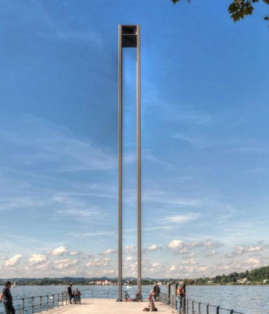
* Bregenz Westmole- 2009. Active; focal plane 32 m (105 ft); flashing white light; there is also a continuous green light at a focal plane of about 7 m (23 ft). 30 m (98
ft) tower, with four square steel posts supporting a box-like lantern. A 2022 photo of this remarkable light is above, Wikimedia has a photo by Friedrich Böhringer, Tobias Wohlrab has a 2023 photo, Jan Olof Nygren has a 2009 photo, and Google has a street view and a satellite view. The light was prefabricated and erected by a crane in a single day in May 2009. It is the signature piece in the reconstruction of the harbor. Bregenz, the capital of Vorarlberg, is at the eastern end of the Bodensee (Lake Constance) and is the only Austrian town on the lake. Huelse has postcard views of an older and a second older pier light at Bregenz. Located at the end of the west mole of Bregenz. Accessible by walking the pier. Site open, tower closed.
- * Bregenz Ostmole
- 2009. Active; focal plane about 26 m (85 ft); continuous red light. Approx. 24 m (79
ft) tower, with four square steel posts supporting a box-like lantern. A photo of both mole lights is available, Christian Rajek has a December 2014 street view, and Google has a street view and a satellite view. Located at the end of the east mole of Bregenz. Accessible by walking the pier. Site open, tower closed.
Donau (Danube) Beacon- * Praterspitz (Donauinsel Endpunkt)
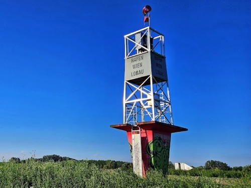
- Date unknown (station established early 1900s). Unlit daybeacon. Approx. 8 m (26 ft) skeletal tower mounted on a red concrete base.Werner Klein's 2024 photo is above right, Manfred Fleiss has a 2017 street view, a 2022 photo is available, and Google has a satellite view. Before World War II this location had a tall skeletal lighthouse: Szávoszt-Vass has a historic photo (halfway down the page). Accessible by paved pathways along the river. Located at the east end of the Donauinsel (Danube Island), the long, narrow island separating the natural Danube from the parallel excavated channel known as the Neue Donau (New Danube). Site open, tower closed.
Burgenland (Neusiedlersee) Lighthouse- The Neusiedlersee is a long, shallow lake near the Hungarian border at the eastern end
of Austria. The lake is 36 km (22 mi) long and 6-12 km (3.5-7.5 mi) wide but nowhere more than 1.8 m (6 ft) deep.
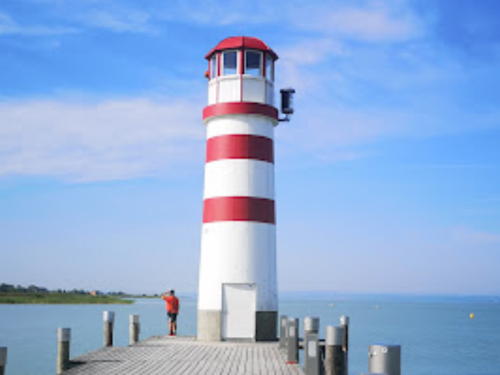
* Podersdorf-am-See- 1998. Active; continuous white light; also a flashing orange light is displayed sometimes as a storm warning. 11 m (36
ft) round metal tower with lantern. Lighthouse painted white with
three red horizontal bands; lantern painted white with a red dome. A 2022 photo is at right, Michael Gustke has a 2016 photo, a 2006 photo is available, Wikimedia has several photos, Peter Vrablec has a 2017 street view, and Google has a satellite
view. Located at the end of a short wooden pier in Podersdorf-am-See. Site
open, tower closed. ARLHS AUT-003.
|

Praterspitz Light, Vienna, June 2024
Google Maps photo by Werner Klein

Podersdorf-am-See Light, Podersdorf-am-See, August 2022
Google Maps photo by Turok
|


