Lighthouses of Mexico: Eastern Baja California

Mexico, officially the United Mexican States (Estados Unidos Mexicanos or EUM), is the second largest country of Latin America and the largest Spanish-speaking nation in the world. With an east coast on the Gulf of Mexico and Caribbean Sea and a long west coast on the Pacific Ocean it has by far the longest coastline in Latin America and, as a result, the largest number of lighthouses.

The Baja California region of Mexico is a peninsula more than 1300 km (800 miles) long, stretching south from the U.S. border at Tijuana to the resorts of Cabo San Lucas. "Baja," as it is usually called, separates the Pacific Ocean on the west from the Sea of Cortés (Gulf of California) on the east. The west coast is popular with surfers and the east coast attracts sea kayakers and ecotourists. Many visitors arrive in Baja California by air or cruise ship, but there are also paved highways reaching most populated areas. Federal Highway 1, the Carretera Transpeninsular, runs 1711 km (1063 mi) from Tijuana at the U.S. border to Cabo San Lucas

Mexico is a federal union of 31 states (estados) plus the capital district, and the states are subdivided into municipalities (municipios). The state of Baja California occupies the northern half of the peninsula and the state of Baja California Sur occupies the southern half, the border between the two states being at latitude 28° north. This page includes lighthouses of the east coast of the peninsula in both states.

Many of the lighthouses of Baja California are in remote areas and are seldom visited. Additional information and photos would certainly be welcome. Because of the rugged topography of the peninsula, most of the lighthouses are short towers located at the tops of bluffs or ridges overlooking the sea.

In Spanish the word for a lighthouse is faro, baliza is a beacon, isla is an island, cabo is a cape, punta is a promontory or point of land, péñon is a rock, arrecife is a reef, bahía is a bay, ría is an estuary or inlet, estrecho is a strait, río is a river, and puerto is a port or harbor.

Mexican lighthouses are managed by the Port Captains and Maritime Affairs Unit (Unidad de Capitanías de Puerto y Asuntos Marítimos, UNICAPAM). Many of the larger light stations are staffed by resident civilian keepers.

ARLHS numbers are from the ARLHS World List of Lights. CF numbers are from the Mexican Cuaderno de Faros (Handbook of Lighthouses). Admiralty numbers are from volume G of the Admiralty List of Lights & Fog Signals. All U.S. NGA numbers are from Publication 111.

General Sources
Online List of Lights - Mexico Pacific
Photos by various photographers posted by Alexander Trabas.
Lighthouses in Mexico
Photos by various photographers available from Wikimedia.
World of Lighthouses - Mexico
Photos by various photographers available from Lightphotos.net.
Navionics Charts
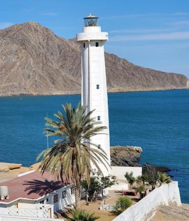
Navigation charts for Baja California.


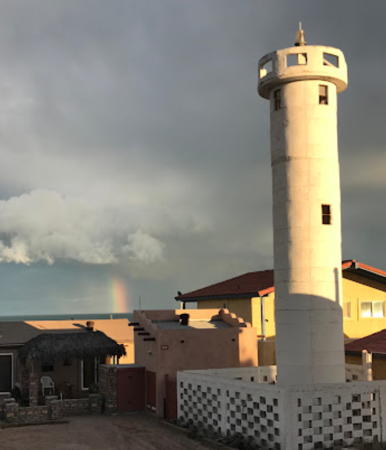
San Felipe Light, San Felipe, October 2011
Wikimedia Creative Commons photo by Tim Buss

Baja California State Lighthouses

San Felipe Municipality: San Felipe Area Lighthouses
The San Felipe Municipality was created in 2022; this area was formerly the San Felipe Borough of Mexicali Municipality.

* San Felipe
Date unknown. Active; focal plane 35 m (115 ft); white flash every 6 s. 22 m (72 ft) cylindrical white concrete tower with four buttresses, adjoining a 1-story keeper's house. Lantern roof painted red. A photo by Tim Buss is at the top of this page, Winfield Sterling has a closeup photo, Lightphotos.net has a photo, Ellen Evanoff has a 2021 photo, Esteban Gomez has a photo, and Google has a street view and a satellite view. This is the one of the most accessible major lighthouses of Baja California. Located on a headland off federal highway 5 in San Felipe, a town of about 17,000 residents. Site open, tower status unknown. . ARLHS MEX-072; CF-02-545; Admiralty G3542; NGA 14756.
* San Felipe Range Front
Date unknown. Active; focal plane 21 m (69 ft); white flash every 3 s. 15 m (49 ft) square pyramidal skeletal tower with gallery; the upper portion carries a white slatted daymark. Google has the street view seen at right and the shadow of the tower is seen in Google's satellite view. Located on the waterfront of the fishing harbor of San Felipe, at the south edge of town. Site open, tower closed. CF-02-550; Admiralty G3542.2; NGA 14757.
* San Felipe Range Rear
Date unknown. Active; focal plane 29 m (95 ft); white light, 1 s on, 1 s off. 19 m (62 ft) square pyramidal skeletal tower with gallery; the upper portion carries a white slatted daymark. Google has a street view and a satellite view. Located two blocks southwest of the front light. Site open, tower closed. CF-02-280.1; Admiralty G3542.21; NGA 14758.
* San Felipe North Wharf
Date unknown. Active; focal plane 15 m (49 ft); red light, 1 s on, 1 s off. 9 m (30 ft) concrete post rising from a 1-story square equipment shelter. Entire lighthouse is white. This light is seen at the right in the street view at right and Google has a closer street view and a distant satellite view. Located at the north end of the main wharf at San Felipe. CF-02-285; Admiralty G3542.5; NGA 14750.
* San Felipe South Wharf
Date unknown. Active; focal plane 15 m (49 ft); green light, 1 s on, 1 s off. 9 m (30 ft) concrete post rising from a 1-story square equipment shelter. Entire lighthouse is white. Google has a street view and a distant satellite view. Located at the south end of the main wharf at San Felipe. CF-02-425; Admiralty G3542.6; NGA 14751.

San Felipe Range Front Light, San Felipe, September 2009
Google Maps street view
* Punta Estrella
Date unknown. Active; focal plane 27 m (89 ft); three white flashes every 12 s. 10 m (33 ft) round cylindrical white concrete tower mounted on a square concrete pad. Andrew Riley has a closeup photo, Armando Sanchez has a street view, and Google has a satellite view. Located about 2 km (1.25 mi) northwest of Punta Estrella and 20 km (13 mi) southeast of San Felipe. Accessible from San Felipe by 4WD. Site open, tower closed. CF-02-260; Admiralty G3543; NGA 14748.5.

San Felipe Municipality: Puertocitos Area Lighthouses
The San Felipe Municipality was created in 2022; this area includes all of the former east coast of the Ensenada Municipality.

* Bahía Santa Maria
Date unknown. Active; focal plane 23 m (75 ft); two white flashes every 10 s. 10 m (33 ft) round cylindrical white concrete tower mounted on a square concrete pad. Sabrina Mason has the closeup 2023 photo seen at right and Google has a satellite view. Located at Campo el Vergel, about 40 km (25 mi) south of San Felipe. Accessible by road. Site open, tower closed. CF-02-255; Admiralty G3543.5; NGA 14748.
* Punta San Fermin
Date unknown. Active; focal plane 22 m (72 ft); four white flashes every 16 s. 13.4 m (44 ft) square pyramidal skeletal tower with gallery. No closeup photo available but Google has a distant satellite view and a very distant street view from highway 5. Located on a headland south of Punta San Fermin. Accessible by 4WD. Site open, tower closed. CF-02-1130; Admiralty G3544; NGA 14744.
* Puertocitos (2)
Date unknown. Active; focal plane 34 m (112 ft); three white flashes every 12 s. Approx. 10 m (33 ft) white concrete tower. No photo available but Google has a satellite view and the top of the tower is probably seen in James Hatton's very distant 2021 street view. The 2017 Cuaderno lists a 6 m (20 ft) square skeletal tower, but the satellite view shows the newer lighthouse. Located on a bluff at Puertocitos. Site open, tower closed. CF-02-250.1; Admiralty G3544.2.

Bahía Santa Maria Light, Campo el Vergel, April 2023
Google Maps photo by Sabrina Mason
Isla Miramar (Isla El Muerto) (1 and 2)
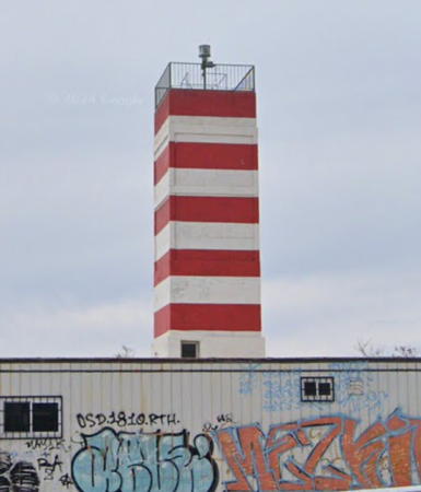
Date unknown. Active; focal plane 20 m (66 ft); two white flashes every 10 s. 10 m (33 ft) round cylindrical concrete tower painted with red and white horizontal bands. Bing's satellite view and Google's satellite view both show two towers at the location. Located at the southeastern tip of the island, off a barren section of the coast about 180 km (115 mi) south of San Felipe. Accessible only by boat. Site and tower open. CF-02-245; Admiralty G3544.5; NGA 14743.
Punta Willard
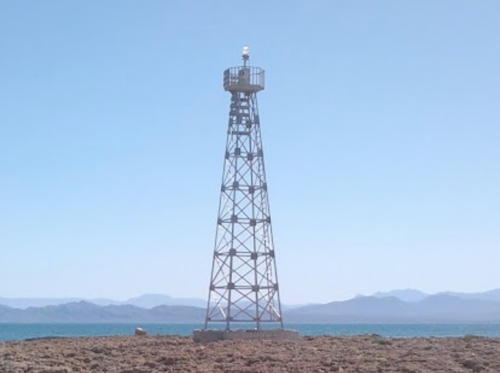
Date unknown. Active; focal plane 14 m (46 ft); two white flashes every 10 s. 12 m (39 ft) square pyramidal skeletal tower with gallery. Juan Francisco Franco Alucano has a photo (a portion is seen at right) and Google has a satellite view. Despite its name the lighthouse is not at Punta Willard but on the shore of an embayment north of that point. Site open, tower closed. CF-02-1125; Admiralty G3545; NGA 14740.

San Quintín Municipality: Isla Ángel de la Guarda Lighthouses
Isla Ángel de la Guarda is a large island separated from the mainland by the Canal (channel) de Ballenas. The island is uninhabited and is protected as a national park. In 2020 the island was transferred from Mexicali Municipality to the new San Quintín Municipality.

Isla Ángel de la Guarda Punta Norte
Date unknown. Active; focal plane 24 m (79 ft); white flash every 6 s. 14 m (46 ft) square pyramidal skeletal tower with gallery. Google has a satellite view and there is a drone view of the lighthouse from 3:28 to 3:40 in a YouTube video. The lighthouse is located at the east end of Isla Granito, a small island just off the northern tip of Isla Ángel de la Guarda. Accessible only by boat. Site open, tower closed. CF-02-225; Admiralty G3546; NGA 14736.

Punta Willard Light, Puertecitos, July 2016
Google Maps photo by Juan Francisco Franco Alucano
Isla Ángel de la Guarda Punta Sur
Date unknown. Active; focal plane 27 m (89 ft); two white flashes every 10 s. 14 m (46 ft) square pyramidal skeletal tower with gallery. No photo available but Bing has a distant satellite view. Located near the southern tip of Isla Ángel de la Guarda, marking the southern entrance to the Canal de Ballenas. Accessible only by boat. Site open, tower closed. CF-02-220; Admiralty G3547; NGA 14728.

San Quintín Municipality: Bahía de los Ángeles and Villa Jesús María Boroughs Lighthouses
San Quintín Municipality was separated from Ensenada Municipality in February 2020. It covers a huge area, roughly half the area of Baja California state, but more on the west coast than on the east coast.

*
Punta Arenas (Bahía de los Ángeles)
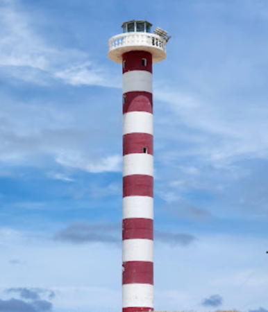
Date unknown. Active; focal plane 13 m (43 ft); four white flashes every 16 s. 10 m (33 ft) round cylindrical concrete tower with gallery, painted with red and white horizontal bands. Bill Gracey's photo is at right, Rob Holcomb has a photo, Wikimedia has a photo, C. Washington has a street view and Bing has a satellite view. Located at the end of a sand spit partially sheltering the waterfront of Bahía de los Ángeles, a small resort town at the end of federal highway 12. Site open, tower apparently open. CF-02-215; Admiralty G3547.6; NGA 14726.
Bahía de San Francisquito
Date unknown. Active; focal plane 14 m (46 ft); white flash every 6 s. 10 m (33 ft) round cylindrical concrete tower with gallery, painted with red and white horizontal bands. Jerry Bazant has a closeup photo and a view from the sea, Zimran Lucero has a very distant aerial photo and Google has a satellite view. This lighthouse marks a small, sheltered harbor at San Francisquito on the east coast of Villa Jesús María borough. Located on the west side of the harbor entrance. Site open; a visitor found the tower open. CF-02-195; Admiralty G3550; NGA 14718.
Punta Arenas Light
Sunset at Punta Arenas Light, Bahía de los Ángeles, July 2012
Flickr Creative Commons photo by Bill Gracey

Baja California Sur State Lighthouses

Mulegé Municipality East Coast Lighthouses
The Mulegé Municipality is the largest municipality by area in Mexico; it occupies the northern third of Baja California Sur and has a population of less than 65,000.

Cabo Vírgenes (1)
Date unknown. Inactive since 2008. 10 m (33 ft) cylindrical concrete tower painted with red and white horizontal bands. No photo available but Google has a satellite view. The lighthouse was replaced by a 10 m (33 ft) square skeletal tower located about 800 m (1/2 mi) northwest (focal plane 16 m (52 ft); four white flashes every 16 s). The Cuaderno has a small photo and Google has a satellite view. Located on a rugged promontory about 15 km (9 mi) north of Santa Rosalía. Site status unknown. ARLHS MEX-024; New light: CF-03-780, Admiralty G3552, NGA 14717.
* Punta Santa Agueda
Date unknown. Active; focal plane 15 m (49 ft); four flashes every 16 s, white or red depending on direction. 12 m (39 ft) square pyramidal skeletal tower with gallery. Tonatiuh Flores has a 2019 photo, Adan Perez has a view of the light in action, and Google has an indistinct satellite view. Located on an islet just off a headland a short distance east of Santa Rosalía. Site open, tower closed. CF-03-765; Admiralty G3556; NGA 14716.
Piedra Blanca (Isla San Marcos)
Date unknown. Active; focal plane 16 m (52 ft); two white flashes every 10 s. 15 m (49 ft) square pyramidal skeletal tower with gallery. Jerry Bazant has a photo and Google has an indistinct satellite view. The Isla San Marcos is a large island about 25 km (15 mi) southeast of Santa Rosalía. Located on an islet sheltering a small anchorage at the northwestern corner of the island. Accessible only by boat. Site open, tower closed. ARLHS MEX-013; CF-03-740.3; Admiralty G3559; NGA 14706.
Punta la Lobera
Date unknown. Active; focal plane 17 m (56 ft) white flash every 6 s. 15 m (49 ft) square pyramidal skeletal tower with gallery. The Cuaderno has a small photo and Google has a satellite view. Located on an islet off the northern tip of Isla San Marcos. Accessible only by boat. Site open, tower closed. CF-03-750; Admiralty G3559.4; NGA 14707.
* Punta Chivato
Date unknown. Active; focal plane 18 m (59 ft); four white flashes every 16 s. 15 m (49 ft) square pyramidal skeletal tower with gallery. Jesus Antonio Romero Espinoza has the photo seen at right, Brett Wyatt has a photo, and Google has a good satellite view. Located on a promontory about 2 km (1.25 mi) north of the Punta Cacarizo Light. Site open, tower closed. ARLHS MEX-162; CF-03-735; Admiralty G3560; NGA 14705.
* Punta Cacarizo (Punta Inés)
Date unknown. Active; focal plane 16 m (52 ft); white flash every 6 s. 15 m (49 ft) square pyramidal skeletal tower with gallery. Alfredo Gómez has a 2022 photo and Google has a good satellite view. Located on a gravel bar at the entrance to Chivato. Site open, tower closed. CF-03-730; Admiralty G3561; NGA 14701.
 

Punta Chivato Light, Mulegé, August 2014
Google Maps photo by Jesus Antonio Romero Espinoza
 
Isla Santa Inés North
Date unknown. Active; focal plane 16 m (52 ft); two white flashes every 10 s. 15 m (49 ft) square pyramidal skeletal tower with gallery. The Cuaderno has a small photo and Google has a satellite view. Located on an islet north of Isla Santa Inés and about 4 km (2.5 mi) east of Punta Cacarizo. Accessible only by boat. Site open, tower closed. ARLHS MEX-168; CF-03-725; Admiralty G3561.4; NGA 14702.
Isla Santa Inés South
Date unknown. Active; focal plane 16 m (52 ft); two white flashes every 10 s. 15 m (49 ft) square pyramidal skeletal tower with gallery. The Cuaderno has a small photo and Google has a satellite view. Located at the southern tip of Isla Santa Inés, about 8 km (5 mi) southeast of Punta Cacarizo. Accessible only by boat. Site open, tower closed. ARLHS MEX-169; CF-03-720; Admiralty G3561.8; NGA 14703.
** Mulegé (Muleje, Punta El Sombrerito)
Date unknown. Active; focal plane 42 m (138 ft); four white flashes every 16 s. 12 m (39 ft) square white cylindrical concrete tower, with gallery but no lantern, rising from a 1-story keeper's house. A 2022 photo is at right, Maria Guadalupe Aguilar Evangelista has a 2018 closeup photo, Trabas has a photo by Hendrik Martin Porath, Jonathan Haro has a 2016 photo, a distant view is also available, and Google has a satellite view and a distant street view. Located at Punta El Sombrerito atop a large rock marking the entrance to the harbor of Mulegé, a town of about 4000 residents. Accessible by a short hike across the beach followed by a steep climb. Site open, tower evidently open. . ARLHS MEX-118; CF-03-710; Admiralty G3562; NGA 14696.
Punta Agujas (2?)s
Date unknown. Active; focal plane 17 m (56 ft); two white flashes every 10 s. 15 m (49 ft) square pyramidal skeletal tower (?) with gallery. The Cuaderno has a small photo and Google has a distant satellite view. The satellite view suggests that the skeletal tower has been replaced by a round concrete tower. Located at the eastern entrance to the Bahía de Concepción, about 5 km (3 mi) east of Mulegé. Site open, tower closed. CF-03-705; Admiralty G3562.2; NGA 14697.
Punta Theresa (2?)
Date unknown. Active; focal plane 16 m (52 ft); three white flashes every 12 s. 8 m (26 ft) pyramidal skeletal tower. The Cuaderno pictures that tower and Google has a satellite view. No photo available. Located on a rugged cape on the east side of the Cerro Colorado peninsula. CF-03-700; Admiralty G3562.45; NGA 14695.
Isla San Idelfonso
Date unknown. Active; focal plane 17 m (56 ft); four white flashes every 16 s. 12 m (39 ft) round cylindrical concrete tower with gallery painted with red and white horizontal bands. No photo available but Bing has a satellite view. Located at the south end of a small island about halfway between Mulege and Loreto. Accessible only by boat. Site open, tower closed. CF-03-695; Admiralty G3562.5; NGA 14694.

Mulegé Light, Mulegé, March 2022
Google Maps photo by BELA

Loreto Municipality Lighthouses
* Loreto (2)
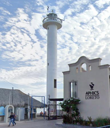
Date unknown (recent; station established 1912). Active; focal plane about 25 m (82 ft); two white flashes every 10 s. Approx. 22 m (72 ft) round cylindrical white concrete tower with gallery. Alejandro Cabrera's July 2009 photo is at right, Adan Perez has a 2018 photo, Trabas has a photo by Hendrik Martin Porath, and Google has a street view and a satellite view. NGA formerly listed a 12 m (39 ft) skeletal tower at Loreto, and that tower was in place at least as late as 2005. Founded in 1697, Loreto is the oldest town of Baja California; it served as the capital of both Upper and Lower California until 1777. Located at the base of the north breakwater of the marina at Loreto. Site open, tower closed. . CF-03-685; Admiralty G3563; NGA 14688.
Punta Lobos (2?)
Date unknown. Active; focal plane 10 m (33 ft); four white flashes every 16 s. 12 m (39 ft) round white concrete tower. No photo available but Google has a satellite view. Located on the sharp northeastern tip of Isla Carmen, a large island off Puerto Escondido. Accessible only by boat. Site status unknown. CF-03-675; Admiralty G3563.58; NGA 14685.
Bahía Salinas
Date unknown. Inactive, probably since the 1980s. Approx. 12 m (39 ft) round cylindrical concrete block tower, formerly painted with red and white horizontal bands, now in ruins. Brian Yount has a 2023 photo, Rafa Murillo has a closeup, and Google has a satellite view and a very distant street view. This light guided vessels to a salt works that closed in 1984. Located on the east side of the entrance to a bay on the east side of Isla Carmen. Accessible only by boat. Site open, tower closed.
Isla del Carmen (Punta Arena)
Date unknown. Active; focal plane 12 m (39 ft); two white flashes every 10 s. 10 m (33 ft) square skeletal tower with gallery, painted white. Google has a good street view and a satellite view. Located on the southwestern tip of Isla del Carmen. Accessible only by boat. Site open, tower closed. CF-03-680.1; Admiralty G3563.52; NGA 14680.
Punta Coyote (Puerto Escondido)
Date unknown. Active; focal plane 15 m (49 ft); white flash every 6 s. 14 m (46 ft) square skeletal tower with gallery, painted white. The Cuaderno has a small photo and Google has a satellite view and a very distant sea view. Located on the east side of the entrance to the bay of Puerto Escondido. Site open, tower closed. CF-03-660; Admiralty G3563.5; NGA 14684.
Faro de Loreto
Loreto Light, Loreto, July 2009
Flickr Creative Commons photo by Alejandro Cabrera
[Puerto Escondido East]
Date unknown. Active; focal plane 10 m (33 ft); red flash every 5 s. 7.5 m (25 ft) concrete post surrounded by a spiral stairway. The Cuaderno has a small photo and Google has an indistinct satellite view and a distant street view. Located on an arm of the mainland opposite the west breakwater at the entrance to Puerto Escondido. Site open, tower closed. CF-03-670.4; Admiralty G3563.511.
* [Puerto Escondido]
Date unknown. Active; focal plane 11 m (36 ft); white flash every 6 s. 7 m (23 ft) square white skeletal tower. Google has a street view and a satellite view. Located at the foot of the pier in Puerto Escondido. Site open, tower closed. CF-03-665; Admiralty G3563.51.
Isla Monserrat
Date unknown. Active; focal plane 20 m (66 ft); four white flashes every 16 s. 10 m (33 ft) square skeletal tower with gallery, painted white. The Cuaderno has a small photo and the tower is seen in Google's satellite view. Monserrat is an island about 8 km (5 mi) in diameter and 25 km (15 mi) southeast of Isla Carmen. Located on the southern tip of the island. Accessible only by boat. Site open, tower closed. CF-03-635; Admiralty G3563.85; NGA 14668.

La Paz Municipality East Coast Lighthouses
La Paz is the capital of the state of Baja California Sur and a major city with a population of about 250,000. The La Paz Municipality occupies the narrow section of the peninsula leading to the Los Cabos area.
Isla de San José Southwest Point (Punta Salinas) (1)
Date unknown. Inactive. 14 m (46 ft) round cylindrical concrete tower, originally painted with red and white horizontal bands. Lantern removed, and the tower is falling into ruin. Next to the lighthouse is the active light (focal plane 12 m (39 ft); four white flashes every 16 s) on a 7.5 m (25 ft) square skeletal tower. No photo available but Google has a satellite view. Located on a sandy point on the west side of the Isla de San José, about 7 km (4.5 mi) east of San Evaristo on the mainland. The lighthouse guided vessels to a salt works, now abandoned. Accessible only by boat. Site open, tower probably open but dangerous. New light: CF-03-595; Admiralty G3565.08; NGA 14641.
Isla Partida (Los Islotes) (2)
Date unknown. Active; focal plane 40 m (131 ft); two white flashes every 10 s. 12 m (39 ft) square skeletal tower with gallery, painted white. The Cuaderno has a small photo, Hiroki Neko has a distant sea view, and Google has a distant satellite view. An older, smaller skeletal tower stands next to the current light. This light marks the northern entrance to the bay of La Paz. Located on Isla Lobos, a small island off the northern tip of the much larger Isla Partida. Accessible only by boat. Site status unknown. CF-03-580; Admiralty G3566; NGA 14600.
* La Paz Second Range Rear
Date unknown. Active; focal plane 19 m (62 ft); white flash every 2 s. 7 m (23 ft) square white concrete tower. Google has a street view and a satellite view. The front light is on a 5 m (16 ft) tower. Located on the Colina Capristano in La Paz. Site status unknown, probably open; tower closed. CF-03-440.1; Admiralty G3573.1; NGA 14616.
* Punta Prieta (La Paz)
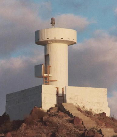
Date unknown (station established 1906). Active; focal plane 30 m (98 ft); three white flashes every 12 s. 20 m (66 ft) square cylindrical masonry tower rising from a 2 or 3-story building. Lighthouse painted with red and white horizontal bands. Nobuo Tsuboi's 2015 view from the sea is at right, a 2012 photo also shows the red and white bands, Javier Rodríguez has a 2009 closeup photo showing the tower all white, and Google has a 2019 street view and a satellite view. Punta Prieta lies about 8 km (5 mi) north of La Paz and this is the light guiding vessels approaching the harbor. The lighthouse is surrounded by a Pemex petroleum facility. Located beside highway 11 on the point of the cape. Site open, tower closed. ARLHS MEX-127; CF-03-435; Admiralty G3570; NGA 14588.

Punta Prieta Light, La Paz, October 2015
ex-Google Plus photo by 坪井伸夫 (Nobuo Tsuboi)
[Islote de la Reina (Arrecife de la Foca) (2)]
2008 (?). Active; focal plane 14 m (46 ft); white flash every 6 s. 7 m (24 ft) triangular skeletal mast, painted white. This is one of the best known dive sites of Baja California, and visitors often mention the lighthouse. The Cuaderno has a small photo and Bing has a satellite view. The original light, described as a round metal tower, was destroyed by Hurricane Henriette in September 2007. Located on a rocky islet just off the northern tip of Isla Cerralvo. ARLHS MEX-113; CF-03-365.1; Admiralty G3575.6; NGA 14584.
Piedras Gordas (Isla Jacques-Cousteau, Isla Cerralvo)
Date unknown. Active; focal plane 21 m (69 ft); two white flashes every 10 s. 11 m (36 ft) square skeletal tower with gallery, painted white. The Cuaderno has a small photo and Google has a satellite view. In 2009 the Mexican government changed the name of Isla Cerralvo to Isla Jacques-Cousteau in honor of the famous French oceanographer and naturalist (1910-1997), who visited the island many times in his research. The island is about 29 km (18 mi) long; located 65 km (40 mi) east of La Paz, it is separated from the mainland by a channel about 10 km (6 mi) wide. The light is located on the southwestern tip of the island. Accessible only by boat. Site open, tower closed. CF-03-360; Admiralty G3576; NGA 14576.
Bahía la Ventana (1 and 2) (Punta Gorda)
Date unknown. Active; focal plane 18 m (59 ft); white flash every 6 s. 12 m (39 ft) square skeletal tower with gallery, painted white. An older tower of roughly the same size stands mext to the active light. An aerial photo is available and Google has a satellite view. Located on the beach at the north end of the Bahía la Ventana, about 4 km (2.5 mi) north of El Sargento. Site open, tower closed. CF-03-350; Admiralty G3577; NGA 14580.
#Punta Arena de la Ventana (Las Arenas) (1)
Date unknown. Inactive since 2009. 10 m (33 ft) cylindrical white concrete tower with gallery, mounted on a square concrete base. Ramlop Ramirez has a 2017 photo (also seen at right) but Isaac Montoya's 2023 drone view confirms that the old lighthouse has been removed. Located close to the new lighthouse (next entry). Site open, tower closed.
* Punta Arena de la Ventana (Las Arenas) (2)
2009 (station establishment date unknown). Active; focal plane about 28 m (92 ft); three white flashes every 12 s. Approx. 25 m (82 ft) round cylindrical concrete tower with gallery, painted with red and white horizontal bands. Isaac Montoya has a 2023 photo, Ramlop Ramirez has a 2017 photo (also seen at right), another 2017 photo is available, and Google has a satellite view. Located 70 km (44 mi) southeast of La Paz overlooking the Cerralvo Channel. The lighthouse appears to be about 1.5 km (1 mi) from the nearest main road and is probably accessible by 4WD. Site open, tower closed. ARLHS MEX-122; CF-03-345; Admiralty G3578; NGA 14572.

Punta Arena de la Ventana Light, La Paz, July 2017
Google Maps photo by J.J. Ramlop Ramirez

Information available on lost lighthouses:

Notable faux lighthouses:

Adjoining pages: East: Northwest Coast | South: Southwestern Baja California

Return to the Lighthouse Directory index | Ratings key

Posted June 2002. Checked and revised November 21, 2023. Lighthouses: 41. Site copyright 2023 Russ Rowlett and the University of North Carolina at Chapel Hill.