Lighthouses of China: Western Hǎinán

The People's Republic of China (PRC), known officially as Zhōnghuá (中华), has a lengthy coastline, many large harbors, and a large number of lighthouses. The country is divided into 23 provinces and 11 other province-level regions of various special types. The island of Hǎinán, together with some much smaller islands, forms the southernmost and smallest province of China; its name means "South Sea." The island is about 300 km (190 mi) long from northeast to southwest and about 175 km (110 mi) wide at its widest point. The east side of the island faces the South China Sea and the west side faces the Gulf of Tonkin. Hǎinán is separated from the Léizhōu Peninsula of Guǎngdōng province by the 30 km (19 mi) wide Qióngzhōu Strait. Hǎikǒu, facing the strait, is the capital and largest city of Hǎinán. The population of the island is more than 8 million. Hǎinán was governed historically as part of Guǎngdōng but it became a separate province in 1988.

The major ports in Hǎinán include Xiùyīng at Hǎikǒu on the north coast, Sānyà on the south coast, and Bāsuǒ at Dōngfāng on the west coast.

The Xīshā (Paracel) Islands are attached to Hǎinán province and China also considers the Spratly (Nánshā) Islands to be part of the province.

This page describes lighthouse on the west coast of Hǎinán, facing the Gulf of Tonkin. The remainder of the island is covered by the Northern Hǎinán and Eastern Hǎinán pages. The Chinese name for the Gulf of Tonkin is Běibù Wān (Northern Bay) because the gulf is the northern extension of the South China Sea.

There are many languages and dialects spoken in China, but Standard Chinese, often called Mandarin, is official. The pīnyīn system for transliterating Standard Chinese into Latin characters is now the international standard but some locations continue to be known also under the spellings of older transliteration systems. The Chinese word for a lighthouse is dēngtǎ (灯塔). In Standard Chinese jiāo (formerly chiao) is a reef or rock, jiǎo is a cape or headland, dǎo (tao) is an island; yǔ (tsu) or tuózi ("lump") is a small island, hǎi is a sea, wān is a bay, hǎixiá is a strait, hé or jiāng is a river, hékǒu ("river mouth") is an estuary, and gǎng (kang) is a harbor.

Lighthouses in China are maintained by the PRC Maritime Safety Administration.The administration is organized in four regional administrations; Hǎinán is one of the four regions. The Hǎinán Maritime Safety Administration is responsible for the island's lighthouses.

ARLHS numbers are from the ARLHS World List of Lights. CN numbers are the serial numbers used by the Shanghai regional office of MSA. Admiralty numbers are from volume P of the Admiralty List of Lights & Fog Signals. U.S. NGA List numbers are from Publication 112.

General Sources
Lighthouses in Hǎinán
Photos by various photographers available from Wikimedia.
Online List of Lights - Hainan - East Coast, Southwest Coast, and Northwest Coast
Photos by various photographers posted by Alexander Trabas.
Chinese English Pinyin Dictionary
A useful tool for juggling the representations of Chinese names.
GPSNavigationCharts
Navigation chart information for Hǎinán.
Google Maps
Satellite view of southern Hǎinán.


Měinǚshí Light, Sānyà, January 2013
Wikimedia Creative Commons photo by Tanya Dedyukhina

Lèdōng County Lighthouse
* Yīnggēzuǐ (Yīnggē Zuǐ) (2)
1992 (station established 1951). Active; focal plane 40 m (131 ft); two white flashes every 10 s. 27 m (89 ft) round cylindrical concrete tower with lantern, gallery, and six ribs. Lighthouse painted white; lantern roof is red. MSA has the photo at righ and Google has a satellite view. Located at the southwestern tip of Hǎinán in Yīnggēhǎizhèn. Site open, tower closed. CN-5104; Admiralty P3357; NGA 20188.
Gōngxiàshí
Date unknown. Active; focal plane 9 m (30 ft); white flash every 4 s. 10 m (33 ft) white concrete tower. No photo available but Google has a fuzzy satellite view. Located on a reef off the west side of Yīnggēhǎizhèn. Accessible only by boat. Site open, tower closed. CN-5105; Admiralty P3357.2.
Lèdōng Guódiàn South Breakwater (2)
Date unknown. Active; focal plane 11.5 m (38 ft); two green flashes every 5 s. Formerly a 10 m (33 ft) round fiberglass and steel tower colored with green and white horizontal bands. It has been replaced by a light on a post. No photo available but Bing has a satellite view. Located on the long south breakwater of the Lèdōng Guódiàn power plant at Yīnggēhǎizhèn. Site and tower closed. CN serial 9310582.01; Admiralty P3357.3.
Lèdōng Guódiàn North Breakwater (2)
Date unknown. Active; focal plane 11.5 m (38 ft); two red flashes every 5 s. Formerly a 10 m (33 ft) round fiberglass and steel tower colored with red and white horizontal bands.It has been replaced by a light on a post. No photo available but Bing has a satellite view. Located on the long north breakwater of the Lèdōng Guódiàn power plant at Yīnggēhǎizhèn. Site and tower closed. CN serial 9310582.02; Admiralty P3357.31.
* Lǐngtóujiǎo
Date unknown. Active; focal plane about 15 m (49 ft); white light occulting once every 4 s. 11.5 m (38 ft) white concrete tower. No photo available but Google has a satellite view. Located on a promontory at the base of a breakwater sheltering Lǐngtóu harbor. Site open, tower closed. CN-5106; Admiralty P3357.65.

Xīgǔdǎo Light, Sānyà, March 2016
PRC Maritime Safety Administration photo

Dōngfāng City Lighthouses
Gǎn'ēnjiǎo (Gǎn'ēn Jiǎo, Kanen Chaio, Thanksgiving Point) (2)
1996 (station established 1951). Active; focal plane 47 m (154 ft); white flash every 6 s. 47 m (154 ft) round cylindrical concrete tower with lantern and gallery. Lighthouse covered with ceramic tiles colored white with narrow red horizontal bands. MSA's photo is at right and Google has a good satellite view. Located on a point of land at Gǎnchéngzhèn, about 35 km (22 mi) south of Dōngfāng. Site status unknown. CN-5107; Admiralty P3357.5; NGA 20184.
* Yúlínjiǎo (Yúlín Jiǎo, Dōngfāng)
Date unknown. Active; focal plane 62 m (203 ft); two white flashes every 6 s. 18.5 m (61 ft) round masonry tower with lantern and gallery. Lighthouse painted white, except the base is unpainted stone. A 2014 photo is at the top of this page, a panoramic view is available, David Schroeter has a 2006 photo, and Google has a satellite view. Located atop a huge rock rising from the beach at the westernmost point of Hǎinán, just west of Bāsuǒ Gǎng. Accessible by road. Site open, tower closed. CN-5108; Admiralty P3337; NGA 20164.
Huánéng Electric Works Range Front
Date unknown. Active; focal plane 32 m (105 ft); continuous red light. 30 m (98 ft) triangular pyramidal skeletal tower. No photo available but Google has an indistinct satellite view. The range guides ships delivering coal for the power plant. Located behind the beach at the power plant on the south side of Bāsuǒ harbor. Site and tower closed. CN-5113.7; Admiralty P3336.4.
Huánéng Electric Works Range Rear
Date unknown. Active; focal plane 46.5 m (153 ft); continuous red light. 48 m (157 ft) triangular pyramidal skeletal tower. No photo available but Google has a satellite view. Located about 250 m (820 ft) east of the front light. Site and tower closed. CN-5113.8; Admiralty P3336.41.
Huánéng Dangerous Cargo Range Front
Date unknown. Active; focal plane 30 m (98 ft); continuous green light. 28 m (92 ft) triangular pyramidal skeletal tower. No photo available but Google has a satellite view. The range guides ships delivering natural gas for the chemical plant. Located behind the beach about 200 m (220 ft) north of the Electric Works Front Light. Site and tower closed. CN serial 9510236; Admiralty P3336.43.
Huánéng Dangerous Cargo Range Rear
Date unknown. Active; focal plane 41 m (135 ft); continuous green light. 40 m (131 ft) triangular pyramidal skeletal tower. No photo available but Google has a satellite view. Located about 250 m (820 ft) east southeast of the front light. Site and tower closed. CN serial 9510235; Admiralty P3336.44.
Bāsuǒ Gǎng West Breakwater
Date unknown. Active; focal plane 10 m (33 ft); green flash every 3 s. 9 m (30 ft) round cylindrical concrete tower, painted green. No photo available but Google has a satellite view. Located at the end of the west breakwater of Bāsuǒ Gǎng. Site status unknown. CN-5112; Admiralty P3337.3; NGA 20180.

Gǎn'ēnjiǎo Light, Ganchengzhen
PRC Maritime Safety Administration photo
Bāsuǒ Gǎng North Breakwater
Date unknown. Active; focal plane 9 m (30 ft); red flash every 3 s. 7 m (23 ft) round cylindrical concrete tower, painted red. No photo available but Google has a satellite view. Located at the end of the north (main) breakwater of Bāsuǒ Gǎng. Site status unknown. CN-5113; Admiralty P3337.1; NGA 20176.
* Bāsuǒ Gǎng Range Front (2)
1997 (station established 1957). Active; focal plane 15 m (49 ft); continuous red light. 15 m (49 ft) concrete tower, painted white, with a black vertical stripe and a large black upward pointing arrow facing the range line. The lighthouse is at the edge of the sea to right of center in a photo and Google has a satellite view. Bāsuǒ Gǎng is the harbor of Dōngfāng. Located on the waterfront east of the harbor. Site open, tower closed. CN-5109; Admiralty P3337.6; NGA 20168.
Bāsuǒ Gǎng Range Rear (2)
1997 (station established 1957). Active; focal plane 23 m (75 ft); continuous red light. 20 m (66 ft) skeletal mast atop a square cylindrical brick tower, painted white, with a black vertical stripe and a large black downward pointing arrow facing the range line. A photo shows the light to the right of center and Google has an indistinct satellite view. Located 260 m (850 ft) east of the front light. Site status unknown. CN-5110; Admiralty P3337.61; NGA 20172.
Shàng'ànshi
Date unknown. Active; focal plane 7 m (23 ft); two white flashes every 5 s. 9 m (30 ft) concrete tower painted black with one red horizontal band. No photo available and the light is not shown in Bing's satellite view. Located on a shoal about 5 km (3 mi) northeast of Bāsuǒ Gǎng. Accessible only by boat. Site status unknown. CN-5114; Admiralty P3337.88.
Sìgèng Shā West
2007. Active; focal plane 31 m (102 ft); two white flashes every 6 s. 34 m (112 ft) round white concrete tower with lantern and gallery. No photo available and the light is not shown in Bing's satellite view. Located about 3 km (2 mi) off a sand spit at Sìgèngzhèn. Accessible only by boat. Site status unknown. CN-5115; Admiralty P3337.89; NGA 20162.
Sìgèng Shā North
Date unknown. Active; focal plane 21.5 m (70 ft); white flash every 4 s. 19 m (62 ft) white concrete tower. No photo available but Google has a satellite view. Located just off the sand spit about 8 km (5 mi) northeast of the west lighthouse. Accessible only by boat. Site status unknown. CN-5116; Admiralty P3337.9.

Chāngjiāng County Lighthouses
Chānghuá Gǎng
Date unknown. Active; focal plane 12 m (39 ft); white flash every 3 s. 12 m (39 ft) round white concrete tower. No photo available but Google has a fuzzy satellite view. Located at an inlet at Chānghuá in southernmost Chāngjiāng County. Site status unknown. CN-5118; Admiralty P3338.1.
Jùnbìjiǎo (Jùnbì Jiǎo)
1997. Active; focal plane 96 m (315 ft); white flash every 8 s. 8 m (26 ft) octagonal cylindrical concrete tower with gallery. Lighthouse covered with white ceramic tiles. No photo available but Google has a satellite view. Located on a promontory about 35 km (22 mi) north of Dōngfāng. Site status unknown. CN-5119; Admiralty P3338.2; NGA 20160.

Dānzhōu City Lighthouses
Dānzhōu occupies the northwestern corner of Hǎinán and has a major port sheltered by the Yángpǔ Peninsula. The city's population is approaching one million.

Guānyīnjiǎo (Guānyīn Jiǎo, Kuan-yin Chiao)
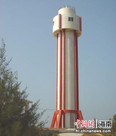
Date unknown. Active; focal plane 60 m (203 ft); three white flashes every 9 s. 25 m (82 ft) round cylindrical concrete tower with gallery and a round watch room structure. Lighthouse covered with white ceramic tiles colored white narrow red vertical stripes. A photo is at right and Google has a satellite view. Located on heights behind a headland about 50 km (30 mi) northeast of Dōngfāng and 35 km (22 mi) southwest of Yángpǔ. Site status unknown. CN-5123; Admiralty P3338.4; NGA 20156.
Dàchánjiāo Northeast
Date unknown. Active; focal plane 14 m (46 ft); white flash every 2 s. 9 m (30 ft) round green concrete tower. No photo available but Google has a satellite view. Located on a reef about 5 km (3 mi) off the entrance to Yángpǔ harbor. CN-5125.1; Admiralty P3338.52.
Páipǔ (P'ai-pu-Shih)
Date unknown. Active; focal plane 9.5 m (31 ft); two white flashes every 6 s. 8 m (26 ft) white masonry tower. No photo available but Google has an indistinct satellite view. Located on the beach at the entrance to a small harbor on the south side of Yángpǔ. Site status unknown. CN-5124; Admiralty P3338.6.
Yángpǔ Gǎng No. 1 Range Front (2)
Date unknown. Active; focal plane 41 m (135 ft); continuous red light. This was described as a 41 m (135 ft) square skeletal tower but Bing's current satellite view shows a square white concrete tower. This is the entrance range for Yángpǔ. Located in the center of Yángpǔ Bay. Site and tower closed. CN serial 9510511; Admiralty P3338.65.
Yángpǔ Gǎng No. 1 Range Rear (2)
Date unknown. Active; focal plane 55 m (180 ft); continuous red light. This was described as a 55 m (180 ft) square skeletal tower but Bing's current satellite view shows a square white concrete tower. Located about 200 m (1/8 mi) east of the front light. Site and tower closed. CN serial 9510512; Admiralty P3338.651.
Yángpǔ Gǎng No. 2 Range Front
Date unknown. Active; focal plane 48 m (157 ft); continuous red light. 15 m (49 ft) square skeletal tower. The tower also carries a triangular daymark, point up. No photo available but Google has a satellite view. Located in the commerical dockyard of Yángpǔ harbor. Site and tower closed. CN-5132; Admiralty P3338.74.
Yángpǔ Gǎng No. 2 Range Rear
Date unknown. Active; focal plane 25 m (82 ft); continuous red light. 20 m (66 ft) square skeletal tower. The tower also carries a triangular daymark, point down. No photo available but Google has a satellite view. Located about 600 m (3/8 mi) northeast of the front light. Site and tower closed. CN-5133; Admiralty P3338.741.

Guānyīnjiǎo Light, Danzhou, 2004
PRC MSA Hǎinán Office photo posted by ChinaNews.com
Yángpǔjiǎo (Yángpǔ Jiǎo)
Date unknown. Active; focal plane 14 m (46 ft); four white flashes every 12 s. Approx. 12 m (39 ft) round concrete tower, probably painted red. No photo available but Google has an indistinct satellite view. Located on a small island on the north side of the entrance to Yángpǔ harbor. Accessible only by boat. Site status unknown. CN-5127; Admiralty P3338.7.
Shénjiānjiǎo
Date unknown. Active; focal plane 29.5 m (97 ft); white flash every 4 s. 15.5 m (51 ft) round white concrete tower. No photo available but Google has a satellite view. Located in an oil terminal on the northwest side of Yángpǔ. Site and tower closed. CN-5150; Admiralty P3338.8.
Bīngmǎjiǎo (Bīngmǎ Jiǎo, Yángpǔ Point) (2)
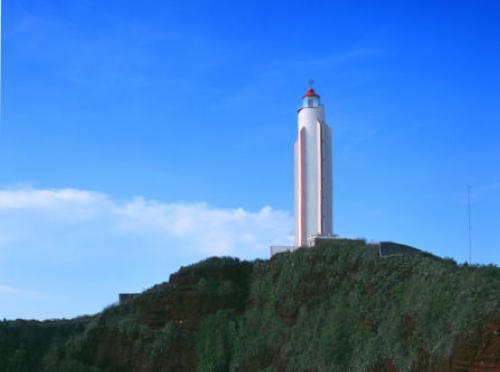
1995 (station established 1951). Inactive since about 2017. 41 m (135 ft) round cylindrical concrete tower with lantern, gallery, and six ribs. Lighthouse painted white with red vertical stripes along the ribs; lantern painted red. A photo is at right, Roy Ding has a December 2017 photo showing both the old and new lighthouses, Huitu.com has a commercial aerial view of the two lighthouses, and Google has a satellite view. The first light was an 8 m (26 ft) stone tower. Located on a bluff near Émàn on the northwestern coast of Hǎinán. Site status unknown. ARLHS PRC-010.
Bīngmǎjiǎo (Bīngmǎ Jiǎo, Yángpǔ Point) (3)
2017 (?) (station established 1951). Active; focal plane 71 m (233 ft); white flash every 6 s. 41 m (135 ft) round cylindrical concrete tower with lantern atop a round observation room. Lighthouse painted white; lantern painted red. Roy Ding has a December 2017 photo showing both the old and new lighthouses and Google has a satellite view. Located a few meters north of the previous lighthouse. Site status unknown. CN-5044; Admiralty P3339; NGA 20152.

1995 Bīngmǎjiǎo Light, Dānzhōu
PRC MSA Hǎinán Office photo
Línchāngjiāo
Date unknown. Active; focal plane 8.5 m (28 ft); two red flashes every 6 s. 10 m (33 ft) round red masonry tower. No photo available but Bing has an indistinct satellite view. Located at the west end of a long shoal obstructing entrance to Houshui Bay. Accessible only by boat. Site open, tower closed. CN-5043. Admiralty P3340.8.
Tóu Pái
Date unknown. Active; focal plane 9 m (30 ft); two green flashes every 6 s. 10.5 m (34 ft) round green concrete tower. No photo available but Bing has an indistinct satellite view. Located at the east end of a long shoal obstructing entrance to Houshui Bay. Accessible only by boat. Site open, tower closed. CN-5041. Admiralty P3340.6.

Information available on lost lighthouses:

Notable faux lighthouses:

Adjoining pages: North: Northeastern Hǎinán | South: Xīshā (Paracel Islands) | West: Northern Vietnam

Return to the Lighthouse Directory index | Ratings key

Posted February 11, 2009. Checked and revised July 24, 2025. Lighthouses: 33. Site copyright 2025 Russ Rowlett and the University of North Carolina at Chapel Hill.