Lighthouses of East Ukraine: Western Crimea

The Directory's pages for Crimea describe the lighthouses as they existed before the start of the current conflict between Ukraine and Russia. No changes will be made until there is a stable agreement that stops the fighting. Russian occupied territories in Ukraine are identified as East Ukraine.

Crimea is a peninsula on the north side of the Black Sea, attached to the mainland by a narrow isthmus. The territory has a long and complicated history. It was annexed to the Russian Empire in 1783. In the Soviet Union it was at first an autonomous republic and later an oblast (province) within the Russian Federation. In 1954 Crimea was transferred from the Russian Federation to the Ukrainian Soviet Socialist Republic. When the Soviet Union collapsed in 1991 Crimea became part of the newly-independent nation of Ukraine. However, Russia continued to occupy several important military bases in the territory, including the home port of the Black Sea Fleet in Sevastopol'.

In March 2014 Russia annexed Crimea, leaving the Ukrainian coast in two sections: the Bight of Odessa in the west and the northwestern side of the Sea of Azov in the east. The annexation of Crimea has not been accepted by Ukraine or recognized internationally. Important note: The Lighthouse Directory's mission and task is to describe lighthouses without offering any comment or opinion on politics or international relations. Our descriptions are always of the actual situation whatever it may be. The Crimean lighthouses are described here as Russian because de facto Russia possesses and operates them.

The members of the Russian Federation are called federal subjects (sub'yekty federatsii, Субъекты федерации). Sevastopol' was admitted to the Russian Federation as a federal city (gorod federalnogo znacheniya, город федерального значения): the same status held by Moscow and by St. Petersburg. The rest of Crimea was annexed as the Republic of Crimea (Respublika Krym, Республика Крым). This brought the number of federal subjects to 85. The Republic of Crimea is divided into 14 districts (raions, районы) and 11 cities (goroda, города).

This page includes lighthouses of the west coast of the Republic of Crimea north of Sevastopol'.

Most of the lighthouses of Crimea were destroyed or heavily damaged during World War II (or the Great Patriotic War, as it is called in Russia). German troops invaded in 1941 and captured all of the peninsula except for some of the highest mountains; Sevastopol' surrendered in July 1942 after a bitter nine-month siege. Soviet troops drove the Germans out in equally heavy fighting in 1944.

The Russian word for a lighthouse is mayak (маяк); ostrov is an island, poluostrov is a peninsula, kosa is a sandy spit, rif is a reef, mys is a cape, bukhta is a bay, zaliv is a larger bay or gulf, proliv is a strait, reka is a river, and gavan' is a harbor.

Russian lighthouses are owned by the Russian Navy and maintained by the Office of Navigation and Oceanography (Управление навигации и океанографии).

ARLHS numbers are from the ARLHS World List of Lights. Admiralty numbers are from volume N of the Admiralty List of Lights & Fog Signals. U.S. NGA List numbers are from Publication 113.
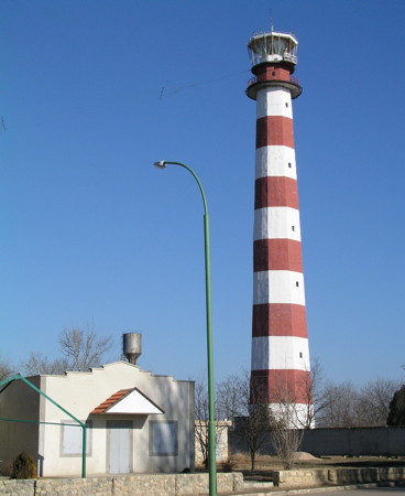
Yevpatoriya Light
Yevpatoriya Light, Yevpatoriya, January 2005
photo copyright Protsko; used by permission
General Sources
Derzhhidrohrafiyu - Lighthouses
Photos and historical information on the Ukrainian State Hydrography web site. (Ukraine continues to consider the Crimean lighthouses as Ukrainian, and there is no comparable Russian reference.)
Online List of Lights - Ukraine
Photos by various photographers posted by Alexander Trabas. (Trabas follows the Admiralty in retaining Crimean lights under Ukraine.)
Lighthouses in Ukraine
The ARLHS Ukraine listing; photos contributed by Ukrainian amateur radio operators are available for many of the lighthouses. (ARLHS maintains the Crimean lighthouses with the UKR designation.)
Lighthouses in Crimea
Photos by various photographers available from Wikimedia. (Wikimedia files photos of Crimean lighthouses under both Ukraine and Russia.)
World of Lighthouses - Crimea
Photos by various photographers available from Lightphotos.net.
Russische Leuchttürme auf historischen Postkarten
Historic postcard images posted by Klaus Huelse (Crimean lighthouses are in a separate group a little more than halfway down the page).
Navionics Charts
Navigation chart for Crimea.
Saky District (Yevpatoria Area) Lighthouses
* Berehove
Date unknown. Inactive but charted as a daybeacon. 5 m (17 ft) square white concrete tower. Natalya Perminova has a photo and Google has a street view and a satellite view. Located atop a steep bluff at the village of Berehove. Site open, tower closed.
* Nikolaevka (Mykolaivka)
Date unknown. Active; focal plane 22 m (72 ft); red flash every 3 s. 11 m (36 ft) square white concrete tower. ARLHS has a photo and Google has a satellite view. Located on a promontory in the town of Nikolaevka. Site open, tower closed. ARLHS UKR-078; Admiralty N5287; NGA 18260.
Solodunova
1986. Active; focal plane 27 m (89 ft); two red flashes every 12 s. 22 m (72 ft) round cylindrical tower with gallery, painted with red and white horizontal bands. The Derzhhidrohrafiyu has a photo, Ruslan Chargazia has a distant photo and Bing has a satellite view. This new lighthouse was named for Rear Admiral Alexander Viktorovich Solodunov, the chief of the hydrology section of the Black Sea Fleet from 1940 to 1952; he was responsible for rebuilding Crimea's lighthouses after the World War II. Located on a barrier beach about 5 km (3 mi) west of Saky and 12 km (7.5 mi) east of Yevpatoriya. Site status unknown. ARLHS UKR-051; Admiralty N5285; NGA 18258.
* Mys Karantinnyy (2)
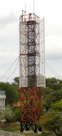
1967 (station established 1897). Active; focal plane 23 m (75 ft); red light, 0.8 s on, 0.8 s off. 21 m (69 ft) square cylindrical skeletal tower with gallery, painted red. The upper 2/3 of the tower carries a slatted daymark painted white with a black vertical stripe. The Derzhhidrohrafiyu has the photo at right, Yurets Dynovsky has a distant street view, and Google has an indistinct satellite view. The name of the lighthouse means "Cape Quarantine." The original lighthouse was destroyed in World War II. Located on the beach at a promontory in downtown Yevpatoriya. Site open, tower closed. ARLHS UKR-066; Admiralty N5284; NGA 18255.
* Yevpatoriya (Mys Yevpatoriyskiy) (3)
1970 (station established 1861). Active; focal plane 53 m (174 ft); two white flashes every 10 s. 52 m (171 ft) octagonal concrete tower with lantern and gallery. Tower painted with red and white horizontal bands; lantern is gray metallic. 1-story keeper's house or administration building. A photo is at the top of this page, Andreas Bradtke has a 2018 photo, ARLHS has a photo, a closeup is available, and Google has a street view and a satellite view. This major lighthouse, the tallest lighthouse on the Black Sea, is similar in design to lighthouses at Berdyansk on the Ukrainian Sea of Azov and at Gelendzhik on the Russian Eastern Black Sea. The original lighthouse was a cast iron skeletal tower prefabricated in London. Despite many complaints about its height and the difficulty of maintaining it in the winter, it survived until World War II. It was replaced in 1955 by a 21 m (69 ft) octagonal brick tower. Located on a prominent point of land about 9 km (5.5 mi) southwest of the small seaport of Yevpatoriya. Site open, tower closed. ARLHS UKR-017; Admiralty N5282; NGA 18252.

Mys Karantinnyy Light, Yevpatoriya
Derzhhidrohrafiyu photo

* Vitino (Nitino, Vityne) (1 and 2)
Date unknown. Active; focal plane 21 m (69 ft); white flash every 4 s. 16 m (52 ft) square cylindrical skeletal tower, painted black. ARLHS has a photo and Google has a satellite view. An older skeletal tower survives next to the present light; Sergey Oreshkin has a photo showing both towers clearly. Located near Nitino, about 10 km (6 mi) northwest of Cape Yevpatoriya. Site open, tower closed. ARLHS UKR-117; Admiralty N5281; NGA 18250.
* Popovka
Date unknown. Active; focal plane 22 m (72 ft); white light, 2 s on, 4 s off. 14 m (46 ft) square pyramidal skeletal tower with gallery, mounted on a square 1-story equipment building. Tower painted black, equipment building white. The tower also carries a horizontally slatted daymark painted white with a black vertical stripe. ARLHS has a photo and Google has a satellite view. Located just off the beach near Mirnyy, about 25 km (15 mi) west of Yevpatoriya. Site open, tower closed. ARLHS UKR-132; Admiralty N5280; NGA 18248.
* Ozero Donuslav South Entrance
Date unknown. Active; focal plane about 17 m (56 ft); red light, 1 s on, 1 s off. Approx. 18 m (59 ft) rectangular concrete tower rising from a 1-story building and carrying a harbor control room and two galleries. Igor Artasevych has the closeup photo at right, Andrey Khokhlushin has a street view and Google has a satellite view. Ozero Donuslav (Donuslav Bay) is a lagoon on the border between the Chornomorske and the Saky Districts. Site of a Russian naval base, the bay is open to the Black Sea through a narrow pass dredged through a sandy barrier. Located on the south side of the entrance to Donuslav Bay. Site open, tower closed. ARLHS UKR-136; Admiralty N5279.85.
Ozero Donuslav First Range Front
Date unknown. Active; focal plane unknown; white light occulting once every 5 s. Approx. 27 m (89 ft) square cylindrical skeletal tower with gallery, painted black. The upper portion of the tower carries a slatted daymark painted black with a white vertical stripe. No photo available but Bing has a distant satellite view. The range guides vessels through the entrance to Donuslav Bay. Located on the south side of Donuslav Bay about 4 km (2.5 mi) southeast of Novoozerne. Site status unknown. ARLHS UKR-142; Admiralty N5279.5; NGA 18249.
Ozero Donuslav Fourth Range Front
Date unknown. Active (?); focal plane about 20 m (66 ft); charted with red light, pattern unknown. Approx. 20 m (66 ft) square cylindrical skeletal tower with gallery, painted black. The front of the tower carries a slatted daymark painted black with a white vertical stripe. A distant view is available and Google has a satellite view. This is an outbound range for vessels leaving the bay. Located on the waterfront on the west side of the Stepnaya harbor on the south side of the bay. Site status unknown. Not listed by the Admiralty.
Ozero Donuslav Fourth Range Rear
Date unknown. Active (?); focal plane unknown; charted with red light, pattern unknown. Approx. 20 m (66 ft) square cylindrical skeletal tower with gallery, painted black. The front of the tower carries a slatted daymark painted black with a white vertical stripe. No photo avalable but Google has a satellite view. Located about 1 km (0.6 mi) southwest of the front light. Site status unknown. Not listed by the Admiralty.

Donuslav South Entrance Light, Sevastopol', August 2008
Google Maps photo by Igor Artasevych
Ozero Donuslav Third Range Front
Date unknown. Active (?); focal plane about 18 m (59 ft); charted with green light, pattern unknown. Approx. 15 m (49 ft) square cylindrical skeletal tower with gallery, painted black. The front of the tower carries a slatted daymark painted black with a white vertical stripe. No lens is seen in a closeup photo by Salech Hcelas. Google has a satellite view. This is an inbound range guiding vessels through a turn in the bay. Located on the waterfront on the north side of the Stepnaya harbor on the south side of the bay. Site status unknown. Not listed by the Admiralty.
Ozero Donuslav Third Range Rear
Date unknown. Active (?); focal plane unknown; charted with green light, pattern unknown. Approx. 20 m (66 ft) square cylindrical skeletal tower with gallery, painted black. The front of the tower carries a slatted daymark painted black with a white vertical stripe. No photo available but Google has a satellite view. Located about 200 m (1/8 mi) southeast of the front light. Site status unknown. Not listed by the Admiralty.

Chornomorske District (Cape Tarkhankut Area) Lighthouses
Ozero Donuslav First Range Rear
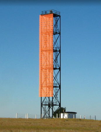
Date unknown. Active; focal plane unknown; white light occulting once every 5 s. Approx. 27 m (89 ft) square cylindrical skeletal tower with gallery, painted black. The front of the tower carries a slatted daymark painted orange. Rost Deore has a closeup photo (also seen at right), Andriy Butenko has a view from across the bay, ARLHS has a photo, and Google has a satellite view. Located on the north side of Donuslav Bay opposite the industrial town of Novoozerne. Site status unknown. ARLHS UKR-141; Admiralty N5279.51; NGA 18249.1.
Ozero Donuslav Second Range Front
Date unknown. Active (?); focal plane about 18 m (59 ft); charted with red light, pattern unknown. Approx. 15 m (49 ft) square cylindrical skeletal tower with gallery, painted black. The front of the tower carries a slatted daymark painted black with a white vertical stripe. No photo available but Google has a satellite view. This is the second range for vessels entering the bay. Located on the waterfront on the north side of the bay about 1 km (0.6 mi) west of the First Range Rear Light. Site status unknown. Not listed by the Admiralty.

Donuslav First Range Rear Light, Sevastopol', October 2012
Google Maps photo by Rost Deore
Ozero Donuslav Second Range Rear
Date unknown. Active (?); focal plane unknown; charted with red light, pattern unknown. Approx. 20 m (66 ft) square cylindrical skeletal tower with gallery, painted black. The front of the tower carries a slatted daymark painted black with a white vertical stripe. No photo available but Google has a satellite view. Located about 1.2 km (3/4 mi) northeast of the front light. Site status unknown. Not listed by the Admiralty.
* Ozero Donuslav North Entrance
Date unknown. Active; focal plane about 9 m (30 ft); red light, 1 s on, 1 s off. 6 m (20 ft) square skeletal tower mounted on a 1-story white concrete building. Salech Hcelas has a photo and Google has a satellite view. Located on the north side of the entrance to Donuslav Bay. Site open, tower closed. Admiralty N5279.8.
Mys Uret
Date unknown. Inactive but charted as a daymark. Approx. 12 m (39 ft) square cylindrical skeletal tower, painted black. The tower carries a dilapidated slatted daymark painted white with a black vertical stripe. No photo available but Google has a satellite view. Located on a promontory on the south side of the Tarkhankut Peninsula, about 16 km (10 mi) east of the Tarkhankut lighthouse. Site open, tower closed. Not listed by the Admiralty.
* Tarkhankut (Mys Tarkhankut)
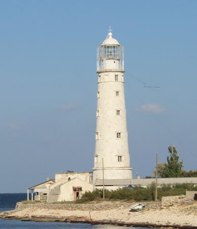
1817. Active; focal plane 36 m (118 ft); two long (1.5 s) white flashes every 7.5 s. 33 m (108 ft) round masonry tower with lantern and gallery. Lighthouse painted white, lantern red. Nearby buildings may be a coast guard or coastal defense station. Vadim Indeikin's photo is at right, a fine closeup photo is available, Andrey Okonetchnikov has a photo, a 2005 photo is available, and Google has a satellite view. This lighthouse stands at the western corner of the diamond-shaped Crimean peninsula, a dangerous headland that sailors called Chortovim Misom (Devil's Cape) because a shoal extends westward for about 8 km (5 mi). The light is built from the same plans as the Khersonesskiy Light in Sevastopol' (see above). Due to its remote location it escaped major damage during World War II. Located on the southern point of Mys (Cape) Tarkhankut, about 5 km (3 mi) southwest of Olenivka. Site status unknown, but clearly the lighthouse can be seen from nearby. ARLHS UKR-016; Admiralty N5278; NGA 18244.
* Pribiinyi (Tarkhankut North)
Date unknown. Inactive and abandoned. Approx. 10 m (33 ft) round tower, painted black with one white horizontal band. A photo is available and Google has a satellite view. Located on a bluff on the northern point of Cape Tarkhankut, about 5 km (3 mi) northwest of Olenivka. Site open, tower closed.
* Chornomorske West
Date unknown. Inactive and abandoned. Approx. 12 m (39 ft) round cylindrical tower with gallery, painted white with two narrow black horizontal bands. A photo is available and Google has a satellite view. Located on a bluff about 4 km (2.5 mi) southwest of the Chornomorske lighthouse. Site open, tower closed.

Tarkhankut Light, Olenivka, September 2014
Wikimedia Creative Commons photo by Vadim Indeikin
* Uzkaya Buhkta (Uzkaya Bay)
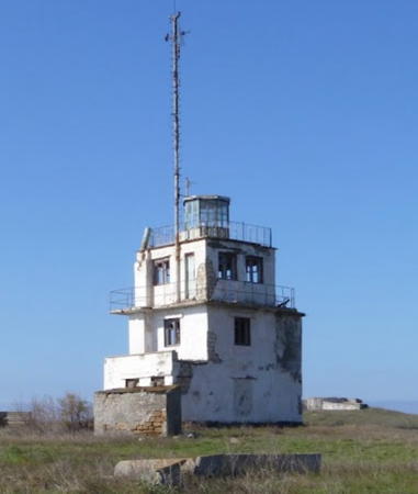
Date unknown. Inactive. Approx. 12 m (39 ft) 3-story building with lantern. A photo is at right, another photo and a closeup are available, and Google has a satellite view. Clearly endangered. Located on the west side of the entrance to Uzkaya Bay and Chornomorske. Site open, tower closed.
* Chornomorske
Date unknown. Active; focal plane about 15 m (49 ft); continuous (?) green light. Approx. 12 m (39 ft) square cylindrical masonry or concrete tower. No photo available, but Bing has a satellite view. This is a directional light guiding vessels to the harbor of Chornomorske, a seaport and resort town with a population of about 11,000. Located on the waterfront of Chornomorske. Site open, tower closed. Admiralty N5274.5.
* Novosel'skov Range Front
Date unknown. Active; focal plane about 20 m (66 ft); red flash every 1.5 s. Approx. 12 m (39 ft) round white concrete tower, the upper portion surrounded by a large cylindrical daymark painted white with a black vertical stripe. Yuri Selitsky has a closeup photo, Alexander Semizhenko has a street view and Google has a satellite view. The range guides vessels into Uzkaya Bay. Located on dunes on the southeast side of the bay. Site open, tower closed. Admiralty N5274.
Novosel'skov Range Rear
Date unknown. Active; focal plane about 95 m (312 ft); red light, pattern unknown. Approx. 16 m (52 ft) round white concrete tower, the upper portion surrounded by a large cylindrical daymark painted white with a black vertical stripe. No photo available but Google has a satellite view. Located in a field about 2.7 km (1.7 mi) southeast of the front light. Site status unknown. Admiralty N5274.1.
 
* [Ozero Panskoye Range Front]
Date unknown. Active; focal plane 15 m (49 ft); one long red flash every 6 s. 13 m (43 ft) post light carrying a slatted daymark painted white with a black vertical stripe. Rost Deore has a closeup photo and Google has a satellite view. Ozero Panskoye is an elliptical lagoon about 10 km (6 mi) northeast of Chornomorske. The lagoon has been put into service as a harbor of refuge and staging area for offshore oil drilling in the Black Sea. The range guides vessels through the narrow entrance to the lagoon. Located beside a highway about 300 m (1000 ft) south of the shore of the lagoon. Site open, tower closed. Admiralty N5273.5.
Ozero Panskoye Range Rear
Date unknown. Active; focal plane 27 m (89 ft); one long red flash every 6 s. 18 m (59 ft) square skeletal tower. The lighthouse carries a slatted daymark, painted white with a black vertical stripe, as well as a white hexagonal topmark. No photo available but Google has a satellite view. Located in a farm field about 700 m (2300 ft) south of the front light. Site status unknown. Admiralty N5273.51.

Uzkaya Buhkta Light, Chornomorske, October 2013
Google Maps photo by Aroks i Shtor
* Yarylgasats'kyy Range Rear
Date unknown. Active; focal plane 15 m (49 ft); continuous green light. Approx. 12 m (39 ft) square cylindrical skeletal tower, painted black and carrying a slatted daymark painted white with a black vertical stripe. No photo available but Google has a satellite view. This is the entrance range for Yarylhachs'ka (Yarylgasats'kyy) Bay. The front light is on a shorter tower. Located in Mizhvodne, on the east side of the bay. Site open, tower closed. Admiralty N5273.31.
* Mys Chernyy (Mizhvodne)
Date unknown. Active; focal plane 21 m (69 ft); white flash every 6 s. Approx. 15 m (49 ft) round cylindrical tower with gallery and a double cone daymark surrounding the upper part of the tower. Lighthouse painted white; the light is on a short mast painted red. Maya Romanova has a photo, ARLHS has a distant view, and Google has a satellite view. Located on a promontory on the north side of the entrance to the bay of Mizhvodne. Site open, tower closed. ARLHS UKR-134; Admiralty N5273.

Rozdolne District Lighthouses
* [Isaycheva (Isaychava)]
Date unknown. Active; focal plane 15 m (49 ft); one long white flash every 5 s. 11 m (36 ft) post painted with orange and white horizontal bands. ARLHS has a photo and Google has a satellite view. Located on a headland near Sjeverne. Site open, tower closed. ARLHS UKR-139; Admiralty N5272; NGA 18220.
Mys Peschanyy (Bakalskoe Spit)
Date unknown. Inactive. Approx. 20 m (66 ft) square skeletal tower with gallery, painted black and mounted on a square platform. No photo available but Bing has a satellite view. The Bakalskoe Spit projects northward into the Karkinyts'ka Bay west of Avrora. Located just off the end of the spit. The area may be accessible by 4WD. Site open, tower closed. ex-Admiralty N5270.

Information available on lost lighthouses:

Notable faux lighthouses:

Adjoining pages: North: Ukraine: Dnipro Basin | South: Sevastopol'

Return to the Lighthouse Directory index | Ratings key

Posted February 19, 2007. Checked and revised September 1, 2021. Lighthouses: 29. Site copyright 2021 Russ Rowlett and the University of North Carolina at Chapel Hill.