Lighthouses of Germany: East Frisia

The Federal Republic of Germany (Bundesrepublik Deutschland in German) occupies a central location in northern Europe with two coastlines, one facing northwest on the North Sea and the other facing northeast on the Baltic Sea. The country's history is long and complex. The large number of historically independent German regions came together in 1871 to form the German Empire. The Empire became a republic after World War I (1914-18). After World War II (1939-45) Germany was divided into two countries, the German Federal Republic in the west, usually called West Germany, and the Communist-led German Democratic Republic in the east, usually called East Germany. After the Communist government collapsed the Federal Republic reunified the nation in October 1990.

East Frisia (Ost-Friesland in German) includes the German coastal region between the Dutch border and the Weser estuary, including the Ems Estuary, the East Frisian Islands, and the Jade Bight. This page lists lighthouses of those areas. Lighthouses on the Weser in the area considered to be part of East Frisia are described on the Bremen and the Weser page.

The Federal Republic is a federation of sixteen states (Länder) and the states are divided into districts (Kreise). The lights on this page are all in the state of Niedersachsen (Lower Saxony). Prior to the unificatiuon of Germany most of East Frisia was governed from 1815 to 1866 by the Kingdom of Hanover while the Jade Bight area was part of the Grand Duchy of Oldenburg.

Interest in lighthouses is strong in Germany and most of the towers are in good condition. A federal law provides blanket protection to historic lighthouses. There is concern, however, that many of the lights may be deactivated in the coming years as navigators depend less and less on them.

In German a lighthouse is a Leuchtturm ("light tower"), plural Leuchttürme. The front light of a range is the Unterfeuer and the rear light is the Oberfeuer. There are many modern range lighthouses and most of these towers are crowned by a topmark: a large, distinctive structure that serves to mark the range clearly in the daytime. Some topmarks are conical, others are funnel-shaped, and some consist of one or more gallery-like rings around the tower.

In German Insel is an island, Riff is a reef, Kap is a cape, Bucht is a bay, Fluss is a river, Mündung is a river mouth or estuary, and Hafen is a harbor. The word Straße ("street") is also used for a waterway or strait. In Frisian fjoertoer ("fire tower") is a lighthouse, eilân is an island, rif is a reef, kaap is a cape, baai is a bay, and haven is a harbor.

Lighthouses in Germany are operated by the regional harbor authority, called the WSA (Wasserstraßen- und Schifffahrtsamt). This page includes the jurisdiction of WSA Ems-Nordsee and part of the jurisdiction of WSA Weser-Jade-Nordsee. The WSA's are linked to and regulated by a federal agency, the Wasserstraßen- und Schifffahrtsverwaltung des Bundes (WSV).

ARLHS numbers are from the ARLHS World List of Lights. DE numbers are the German light list (Leuchtfeuerverzeichnis) numbers as noted on Erich Hartmann's website. Admiralty numbers are from volume B of the Admiralty List of Lights & Fog Signals. U.S. NGA List numbers are from NGA Publication 114.

General Sources
Online List of Lights - Germany North Sea
Photos by various photographers posted by Alexander Trabas. Many of the photos from this area are by Capt. Peter Mosselberger ("Capt. Peter").
Leuchttürme und Leuchtfeuer an der Nordsee
Photos and information posted by Erich Hartmann, a contributor to the Online List of Lights.
Leuchtturm-Atlas
A large site with excellent photos and information on nearly all German lighthouses, maintained by Frank and Birgit Toussaint.
Leuchttürme.net - Ems, Ostfriesland
Outstanding photos by Malte Werning.
Leuchtturmseiten von Anke und Jens
Good photos and and brief accounts for many of the lighthouses, in English.
Deutsche Leuchttürme und Seezeichen
Photos posted by Klause Huelse.
Deutsche Leuchttürme auf historischen Postkarten
Historic postcard images, also posted by Klaus Huelse.
Lighthouses in Lower Saxony
Photos by various photographers available from Wikimedia.
World of Lighthouses - Germany
Photos by various photographers available from Lightphotos.net.
Feste Schifffahrtszeichen - Leuchttürme
Lighthouse information from WSA Weser-Jade-Nordsee.
Germany Lighthouses
Aerial photos posted by Marinas.com.
Interessengemeinschaft Seezeichen e.V.
Germany's national lighthouse preservation organization.
GPSNavigationCharts
Navigation chart information for Germany.


Borkum Großer Light, Borkum, July 2023
Instagram photo by Heike Schwöbel
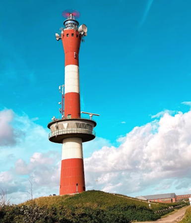

Neuer Leuchtturm, Wangerooge, August 2023
Instgram photo by Rieke Müller

Leer District Lighthouses

Westernmost of the East Frisian Islands, Borkum is a popular seaside spa and resort, accessible by air or by ferry from Emden. The island has a permanent population of about 5200 and is administered as part of the Leer District.

Lightfloat GW/Ems (German Bight Western Approach)
Date unknown. Active; focal plane 17 m (56 ft); white light, 4 s on, 4 s off. Fog horn (three blasts, short-long-short, every 30 s). Unmanned lightship, painted orange, with a light tower amidships. Wikimedia has the photo at right of lightship FS-1, marked as GW-Ems, anchored for maintenance; this is one of three identical automated lightships available for stations in the German Bight. The lightfloat is not shown in Google's satellite view of the station. The station is located dividing the eastbound and westbound channels leading to Elbe and Weser estuaries, about 65 km (40 mi) due north of Borkum. Accessible only by boat. Site open, vessel closed. Admiralty B1051; NGA 10014.
Die Ems (Eemshaven)
Date unknown. Active; focal plane about 16 m (52 ft); five yellow flashes every 20 s. Approx. 17 m (56 ft) post with a broad platform. Entire structure painted yellow. Trabas has Capt. Peter Mosselberger's photo and Google has a satellite view. Located in the Eems River about 2 km (1.25 mi) off Eemshaven. Accessible only by boat. Site open, tower closed. Admiralty B0981; NGA 10040.5.
* [Großes Kaap (Osterems-Bake)]
1872. Daybeacon, never lit. 23.4 m (77 ft) brick beacon topped by a triangular wood daymark. This was the front beacon of a day range with the Alter Leuchtturm (see below) as the rear beacon. Holger Pyrkatz has a 2014 closeup photo, Hans Jürgen Groß has 2019 photo, Rudolf Strut has a street view, and Google has a satellite view. Located on dunes at the western tip of Borkum. Site open, tower closed. .
* [Kleines Kaap (Westerems-Bake)]
1872. Daybeacon, never lit. 11.7 m (38 ft) brick beacon topped by a square wood daymark. This was also the front beacon of a day range with the Alter Leuchtturm (next entry) as the rear beacon. A 2019 closeup photo is available, P. Kusserow has nice view, and Google has a satellite view. Located on dunes at the western tip of Borkum 500 m (0.3 mi) southwest of the Großes Kaap beacon. Site open, tower closed. .

Feuerschiff FS-1, October 2009
Wikimedia Creative Commons photo by SteKrueBe
 
** Borkum (Alter Leuchtturm)
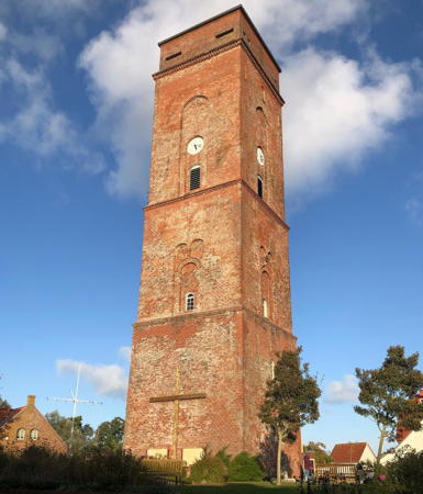
1817 (tower built 1576). Inactive since 1879. 45 m (148 ft) square brick tower, unpainted, attached to 1-1/2 story keeper's house. A 2022 photo is at right, Werning's page has an excellent photo, Wikimedia has several photos, Huelse has a historic postcard view, Karsten Bechstedt has a closeup street view, and Google has a street view and a satellite view. This historic tower functioned as a daybeacon until a lantern was added in 1817. The tower was gutted by fire on 14 February 1879, leading to the construction of the Borkum Großer lighthouse. From 1895 to 1921 the tower was used as a weather and maritime traffic control station. In 1982 ownership of the old tower was transferred to the Borkum history association; after restoration it was opened to the public as a bed and breakfast and meeting venue managed by the area's Lutheran church district. The tower is popular site for weddings. Located at the end of Kirchstraße in the center of the town of Borkum. Site open, tower open (but only for an hour during the morning) on Mondays, Wednesdays, and Saturdays April through October, also on Fridays July through September, and on Saturdays November through March. Owner: Heimatverein der Insel Borkum . Site manager: Ev. Kirchenkreis Lüdenscheid-Plettenberg. ARLHS FED-024.
**** Borkum (Großer Leuchtturm, Neuer Leuchtturm)
1879 (station established 1817). Active; focal plane 63 m (207 ft); two white flashes, separated by 2.7 s, every 12 s; at 46 m (151 ft) there is also a directional light displaying continuous white, red, or green light depending on direction. 60 m (197 ft) round brick tower with a tall (3-story) octagonal base, lantern and gallery. The tower is unpainted gray-brown brick, the base is covered in brown tile; the lantern has a red dome. Heike Schwöbel's 2023 photo is at the top of this page, Werning has a page with great photos, Trabas has an excellent photo by Klaus Potschien, Marion Holtz has a 2022 photo, Wikimedia has photos, Huelse has a historic postcard view, Michiel Naaldenberg has a street view, and Google has a great satellite view. This robust tower is either the second or third tallest brick lighthouse in the world, comparable to the famous Cape Hatteras Light in the U.S. It is the landfall light for the Ems estuary and the port of Emden. Recently restored. Located on Strandstraße at Goethestraße near the west end of the island. Site open; tower open for climbing daily April through October and on Thursday, Friday, and Sunday afternoons November through March. Operator: WSA Ems-Nordsee. . ARLHS FED-009; DE 321300; Admiralty B0970; NGA 10032.

Borkum Alter Light, Borkum, October 2022
Instagram photo by pewalkenhorst
* Borkum (Kleiner Leuchtturm)
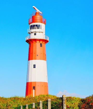
1891. Inactive since 2003. 27 m (89 ft) 16-sided cast iron tower with lantern and double gallery, topped by a radar antenna. Lighthouse painted with red and white horizontal bands. Niels Cooper's 2020 photo is at right, Werning has a fine page for the lighthouse, Mario Haß has a 2023 photo, Huelse has a historic postcard view, and Google has a 2019 street view and a satellite view. The lighthouse was built as part of a program to improve safety for ships entering the Ems; in the same year the directional light was added to the Borkum Großer tower and the Pilsum and Campen lighthouses were built (see below). The light was deactivated August 31, 2003, after changes in the ship channel made it obsolete. However, the tower is being maintained: in the fall of 2006 it was repaired and repainted. Located on the south side of the town of Borkum, at the foot of Süderstraße. Site open, tower closed. Site manager:WSA Ems-Nordsee. . ARLHS FED-015; ex-Admiralty B0972; ex-NGA 10036..
Borkum Düne ("Kuckucksturm")
1928. Inactive since 1982. 8 m (26 ft) square cylindrical skeletal tower with semicircular lantern and square gallery. Tower painted red with a white horizontal band; lantern roof is black. Leuchtturm-Atlas has a closeup, Michael Bührke has a 2021 photo, Werning has a good photo, Huelse also has a good photo, Kai Klein has a 2017 street view, and Google has a satellite view. This tower, nicknamed the "cuckoo tower," formerly carried a directional light; like the Borkum Kleiner lighthouse it was deactivated after changes in the ship channel made it obsolete. There was fear that the property would be sold, but instead an automatic weather station was installed next to the old light, and the lighthouse has been maintained for its historical value. Located a short distance east of the Borkum Kleiner lighthouse; the Anke/Jens site has a photo showing both towers. Site open, tower closed. Site manager: WSA Ems-Nordsee. . ARLHS FED-270; ex-Admiralty B0874.
Fischerbalje
1960. Active; focal plane 15 m (49 ft); two white flashes every 16 s. 16 m (52 ft) round cylindrical lantern, gallery, and watch room supported by tripod pilings. Lantern and watch room painted red with a white band at the base of the watch room. Leuchtturm-Atlas has a good photo, Trabas has a great closeup by Klaus Potschien, a 2022 photo shows the lighthouse under maintenance, and Bing has a satellite view. This lighthouse replaced the former Außenrandzel lighthouse; the lens from Außenrandzel was transferred to Fischerbalje. In early 2005, Borkum officials successfully protested a WSA Emden plan to replace the lighthouse, and stated their belief it should be retained. It was, but the former sector lights were replaced by a much weaker white light that marks the entrance to the channel leading to the Burkanahafen (Burkana Harbor) on the south side of Borkum. Located off the end of the breakwater at Reede Borkum, the ferry terminal at the south end of the island; Accessible by boat and (with caution) on foot at low tide. Site and tower closed. Operator: WSA Ems-Nordsee. . ARLHS FED-023; DE 321600; Admiralty B0976; NGA 10040.

Borkum Kleiner Light, Borkum, May 2020
Instagram photo by Niels Cooper
*** Feuerschiff Borkumriff IV
1956. Decommissioned 1988. 53.7 m (176 ft) 2-masted steel lightship, light displayed from a lantern atop the foremast. Hull painted red, superstructure white; light mast painted white with a single red horizontal band. The original Fresnel lens is mounted in the lantern. This is the last traditional lightship built in Germany. The ship spent its entire career on the Borkumriff station 30 km (19 mi) northwest of the island; when it was withdrawn, on 15 July 1988, it was the last active German lightship. In 1989 it was transferred to the national park service. It is now a museum ship and it also serves as the national park information center for Borkum Island. A 2023 photo by Ralf Pupkes is at right, a 2019 photo is available, the national park has photos, Udo Springfeld has a 2008 photo, Hartmann has a page for the ship, and Google has a street view and a satellite view. Moored in the Burkanahafen near the ferry terminal. Site open; ship open for tours daily except Mondays April through October and on Friday, Saturday, and Sunday afternoons in the winter. Owner/site manager: Nationalpark Niedersächsisches Wattenmeer. . ARLHS FED-002.
Emshörn
1979. Active; focal plane 13 m (43 ft); yellow flash every 4 s. Round tower supporting a large round structure. Lighthouse painted yellow with a black base. Trabas has Rainer Arndt's photo and Google has a satellite view. Located in the Ems estuary about 4 km (2.5 mi) off Eemshaven, Netherlands. Accessible only by boat. Site open, tower closed. DE 321860; Admiralty B0982.
Binnenrandzel
1891. Inactive since 1995. 14 m (46 ft) two-stage tower: a round tower mounted on a square pyramidal skeletal tower. Lighthouse painted red with one white horizontal band. Werning has a photo, Leuchtturm-Atlas also has a closeup photo, and Google has a satellite view. Channel changes made this light obsolete. Located on the east side of the Ems entrance channel opposite Eemshaven in the Netherlands. Accessible only by boat. Site open, tower closed. ex-Admiralty B0982.
* [Ostbake (Oostbake)]
1872. Daybeacon, never lit. 13.3 m (44 ft) round brick tower topped by a mast with a triangular wood daymark. A 2021 closeup photo is available, Manfred Ohler has a 2018 photo and Google has a satellite view. Located on dunes near the eastern tip of Borkum. Site open, tower closed. .

Feuerschiff Borkumriff IV, Borkum
Google Maps photo by Ralf Pupkes
Emden Lighthouses
Emden is a seaport city on the east bank of the Ems River. In its lower course the river also forms the border between Germany and the Netherlands. The city has a population of about 50,000.

*
[Emden West Mole (original lantern)]
1901. Inactive since 1982. Octagonal cast iron lantern, painted white with red trim; the roof is dark gray. This is the original lantern of the Emden West Mole Light (see below). It was relocated as the operator's station at a drawbridge carrying Friedrich-Ebert Straße over the Ems-Jade Canal in downtown Emden. Werning has a photo, Bjoern von der Felsen has a street view and Google has a 2022 street view and a satellite view. Site open, lantern closed.
* Feuerschiff Deutsche Bucht (Amrumbank II)
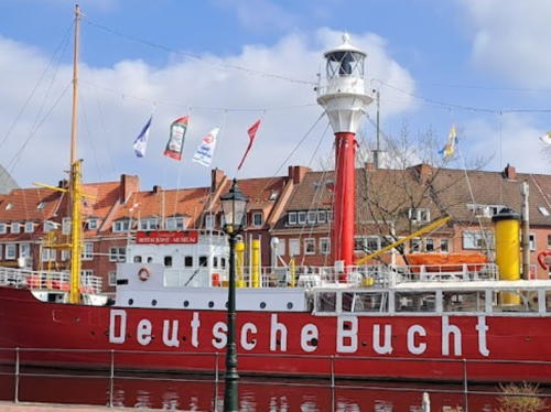
1915. Decommissioned 1983. 52.5 m (172 ft) steel lightship with cylindrical light tower amidships, lantern, and gallery. Hull and light tower painted red, superstructure and lantern painted white. The ship bears the name of its last station Deutsche Bucht (German Bight). After deactivation the ship was donated to a preservation foundation in Emden, which restored it as a museum and restaurant. The ship also has a restaurant, an amateur radio transmitting station and an office of the city registrar where weddings are performed. A 2023 photo is at right, Hartmann has a page for the ship, a 2013 photo and a 2008 photo are available and Google has a street view and a satellite view. Moored in the Ratsdelft, a basin in Emden harbor, with several other historic vessels. The ship was closed for restoration in 2020. Site open, ship normally open daily May through October. Owner/site manager: Museums-Feuerschiff Amrumbank/Deutsche Bucht e. V. . ARLHS FED-139.
[Emden East Mole (3)]
1982 (station established 1902). Active; focal plane 7 m (23 ft); continuous green light. 3 m (10 ft) round metal tower painted green. Trabas has Rainer Arndt's closeup photo and Google has a satellite view. Huelse has postcard views of the first (1912) and second (1956) lighthouses; both were removed after collisions with freighters, in 1954 and 1978, respectively. Located at the end of the long east mole at the entrance to Emden harbor. Site and tower closed. ARLHS FED-080; DE 322210; Admiralty B1024.

Feuerschiff Deutsche Bucht(Amrunbank), Borkum, April 2023
Google Maps photo by Alex S.
Emden West Mole
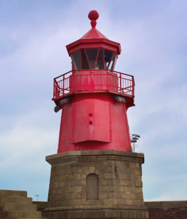
1901. Active; focal plane 9 m (30 ft); continuous light, red or green depending on direction. 10 m (33 ft) octagonal cast iron tower with lantern and gallery mounted on an octagonal stone base. Tower painted bright orange-red. A 2022 photo by Sabrina Werst is at right, Trabas has a great closeup photo by Capt. Peter, Leuchtturm-Atlas has a fine photo, Wikimedia has a 2012 photo, Werning has a photo, Huelse has a historic postcard view, and Google has a satellite view. The lighthouse was renovated in 1982 and the historic lantern was replaced. The original lantern was relocated (see above). In recent years the mole has been closed to the public, although there is a movement to reopen it for access to the lighthouse. Located at the end of the west pier at the entrance to Emden harbor. Site and tower closed; there are good views from the ferries departing for Borkum. Operator: WSA Ems-Nordsee. . ARLHS FED-081; DE 322200; Admiralty B1026.
* Logum Oberfeuer
Date unknown. Active; focal plane 28 m (92 ft); white light occulting twice every 12 . The light is mounted on the side of a wind turbine at the top of a daymark strip painted with red and white horizontal bands. Trabas has Capt. Peter's photo and Google has a satellite view. The range guides vessels in the Ems approaching Emden. The front light is on a post. Located just above the Neuen Seedeich (New Seadike) road along the north side of the Ems about 2.5 km (1.5 mi) west of Emden. Site open, tower closed. DE 322101; Admiralty B1014.1.
* Wybelsum
1971. Active; focal plane 16 m (52 ft); continuous light, white or red depending on direction. 18 m (60 ft) round cylindrical tile-covered tower rising from an octagonal 1-story brick building and supporting an octagonal observation room. Rotating radar antenna. Trabas has a closeup photo by Ulrich Bode, Leuchtturm-Atlas also has a good photo, Werning has a photo, Wikimedia has a photo, and Google has a satellite view. The building was restored in 2021. Located in a large wind farm on the north bank of the estuary about 5 km (3 mi) east of Knock and 10 km (6 mi) west of Emden. Site open, tower closed. Operator: WSA Ems-Nordsee. ARLHS FED-268; DE 322120; Admiralty B1012; NGA 10056.
* Knock (2)
1970 (station established 1888). Active; focal plane 28 m (92 ft); continuous directional light, white, red, or green depending on direction. 55 m (180 ft) harbor control tower attached to a 3-story brick building that contains the Dutch-German Vessel Traffic Control Centre Ems. The tower is a square concrete spire supporting two rooms with technical systems and topped by a round radome of the German Weather Service; the light is displayed from a square gallery-like platform halfway up the tower on the roof of the lower control room. Werning has a page for the lighthouse, Trabas has Capt. Peter Mosselberger's photo, Joachim Knecht has a 2020 photo, Pablo Geilert has a drone view, and Google has a street view and a satellite view. Huelse has a postcard view of the former Knock West lighthouse, located very close to this location from 1888 to 1970. Located at Knock, at a 90° bend in the Ems about 6 km (4 mi) south of Campen and 15 km (9 mi) west of Emden. Accessible by road; there is also a distant view from Delfzijl, across the estuary in the Netherlands. Site open, tower closed. Operator: WSA Ems-Nordsee. . ARLHS FED-128; DE 322000; Admiralty B1010; NGA 10052.

Emden West Mole Light, Emden, June 2022
Google Maps photo by Sabrina Werst

Aurich District Lighthouses

Ems Estuary Lighthouses
** Campen
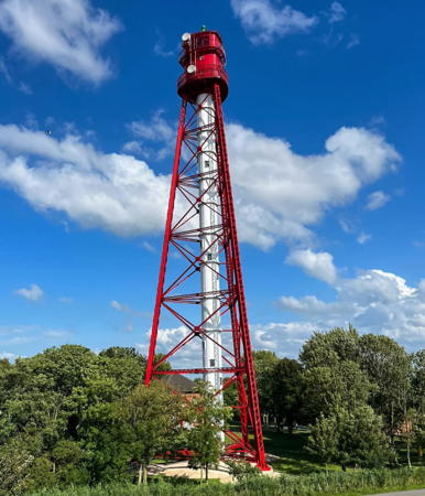
1891. Active; focal plane 62 m (203 ft); directional light, showing a continuous white light along the channel line, a white flash every 5 s in a narrow arc to the right, and four white flashes every 15 s in a narrow arc to the left. 65 m (214 ft) triangular pyramidal skeletal tower with central cylinder, semicircular lantern, watch room, and double gallery. Lighthouse painted red; central cylinder is white, lantern dome green. A 2023 photo is at right, another 2023 photo is available, Werning has a great photo, Leuchtturm-Atlas has a page with a good photo, Trabas has Capt. Peter's photo, Stefan Nitz has a 2024 street view, and Google has a satellite view. Built by the Gute-Hoffnungshütte in Oberhause, this great landmark of civil engineering is Germany's tallest lighthouse and one of the tallest of its type in the world, only a little shorter than the 67 m Recalada a Bahía Blanca lighthouse in Argentina. Locally it is called the Eiffelturm der Nordsee (Eiffel Tower of the North Sea). It guides ships through the channel of the Randzelgat in the lower estuary of the Ems, projecting a narrow beam only 0.3° wide visible for 30 nautical miles (55.5 km or 34.5 mi) to the northwest. The nearby generator building houses a 1906 diesel motor in operating condition, believed to be the world's oldest operating diesel engine still at its original location. The lighthouse was completely restored in a two-year project, 2019-2021. Located on the east bank of the Ems in Campen, about 17 km (11 mi) west of Emden. Site open, tower open for climbing but information is needed on the schedule. Operator: WSA Ems-Nordsee. . ARLHS FED-004; DE 321700; Admiralty B0983; NGA 10048.
** Pilsum
1891. Reactivated (inactive 1919-2005, now privately maintained and unofficial; charted as a landmark); white light occulting twice every 8.5 s. 11 m (36 ft) round cylindrical cast iron tower with a conical roof. No lantern; the light was displayed through a window at the top of the tower. Lighthouse painted with red and yellow horizontal bands. Gerhard Wik has a fine closeup, a 2022 photo is available, Werning has a good photo, José Miguel has a street view, and Google has a satellite view. The lighthouse was built to display a directional light for ships negotiating the narrow Osterems channel east of Borkum. It became obsolete when the channel largely silted up and was no longer in much use. Maintained between the World Wars as a daybeacon, the lighthouse was effectively abandoned at the start of World War II and became a rusted wreck by the 1960s. In 1973 the exterior was restored and painted with its present colorful pattern (originally the lighthouse was all red, later red in the lower 2/3 and yellow above). Another restoration in 1984 included replacement of the roof and ventilator ball. A complete restoration, inside and out, was carried out in 1997-98. In early 2005 the lighthouse was reactivated with a new 60 cm (24 in) lens. The roof was restored again in 2014 and the lighthouse was repainted in 2020. Since 2004 the lighthouse has been a popular location for weddings and it has also served as a movie set. Located on a dike at the eastern entrance to the Ems, about 10 km (6 mi) north of Campen. Accessible by the coastal road. Site open, tower open for tours on selected Sundays. Site manager: Diechacht Krummhörn. . ARLHS FED-018.

Campen Light, Campen, July 2023
Instagram photo by _biggygoeswild_

Ems-Jade Kanal Lighthouses
Built between 1880 and 1888 the Ems-Jade Kanal is 72.3 km (45 mi) long, connecting Emden to the Jadebusen at Wilhelmshaven. Navigation on the canal is limited to small craft.
* Aurich
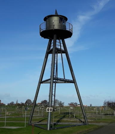
Date unknown. Active; focal plane 12 m (39 ft); white light, 7.5 s on, 7.5 s off. 11 m (36 ft) tapered square skeletal tower, painted white; a red daymark surrounds the middle of the tower and there is a red band around the gallery. Andreas Köhler's 2020 photo is at right, Martin Scislowski has a 2021 photo, Jan Queißer has another photo, Andreas Broschinski has a 2022 street view, and Google has a satellite view. Located on the waterfront in downtown Aurich, marking a sharp turn in the course of the canal. Site open, tower closed.

Norddeich Lighthouses
Norddeich is the mainland terminal for ferries to Juist and Norderney.

#Norddeich Eastmole (relocated)
Date unknown. Inactive. 7 m (23 ft) triangular skeletal tower with lantern and gallery, painted red. Formerly located on the east mole of the Norddeich ferry harbor, the lighthouse was relocated to the west side of the entrance to a parking area for the Ocean Wave amusement complex. Google's 2022 street view and satellite view show that it has been removed. Site open, tower closed. ex-Admiralty B1086.
#Norddeich Westmole (relocated)
Date unknown. Inactive. 7 m (23 ft) square skeletal tower with lantern and gallery, painted green. Formerly located on the west mole of the Norddeich ferry harbor, the lighthouse was relocated to the west side of the entrance to a parking area for the Ocean Wave amusement complex. Google's 2022 street view and satellite view show that it has been removed. Google has a satellite view. Site open, tower closed.ex-Admiralty B1086.1.

Aurich Light, Aurich, June 2020
Google Maps photo by Andreas Köhler

Juist Lighthouses
Juist and Norderney are barrier islands east of Borkum; both islands are popular resorts accessible by ferry from Norddeich. Juist has a permanent population of about 1800 and the population of Norderney is nearly 6000.

*
[Juist Westbake]
1926. Daybeacon, never lit. 9 m (30 ft) tripod tower mostly enclosed by a slatted daymark and topped by a diamond-shaped slatted daymark. Michael Berens has a distant 2022 drone view and Google has an indistinct satellite view. Located on dunes near the western tip of Juist. Site open, tower closed.
*** Memmert (lantern on replica tower)
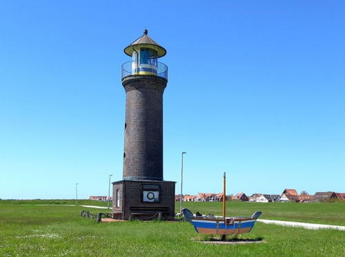
1939 lantern on 1992 tower (original lighthouse inactive since 1986). A decorative light is displayed, white flash every 13 s. 15 m (49 ft) round cylindrical tower with lantern and gallery. Approx. 14 m (45 ft) round brick tower with lantern and gallery, mounted on a square base. The tower is unpainted gray brick except for one white vertical stripe; lantern painted white with gold and blue bands (the colors of the island's flag) at the base and a gray conical roof. Günter Dehne's 2023 photo is at right, Claudia Hake has a 2008 photo, Wikimedia has a 2009 photo, Leuchtturn-Atlas has a page with a photo, Hermann Kaiser has a street view, and Google has a satellite view. The original lighthouse (was similar in appearance but square rather than round; it was built on Memmert, a small sandy island obstructing the passage between Borkum and Juist. Members of the Juister Heimatverein (Juist Historical Society) raised funds to build the replica and install the historic lantern. There is a small museum in the tower. Ruins of the original lighthouse were demolished in 2002. The lantern was removed for restoration in October 2013 and reinstalled in May 2014. Located on the waterfront of Juist, near the ferry terminal. Site open, tower open for climbing on summer evenings. Owner/site manager: Inselmuseum Juist. . ARLHS FED-152.; ex-Admiralty B1044.

Memmert Light, Juist, January 2023
Instagram photo by guenterdehne

Norderney Lighthouses
* [Kap Norderney Bake (3)]
2015 copy of 1871 beacon (first beacon erected 1848). 11.7 m (38 ft) hexagonal brick tower topped by a triangular wood beacon. Carola Ebert has a 2018 closeup photo, Melanie Lange has a 2019 photo, Sven Müller has a street view, and Google has a satellite view. This tower is a traditional symbol of Norderney. When it was found to be in poor condition it was demolished and rebuilt in 2015. Located atop a dune in the town of Norderney. Site open, tower closed.
**** Norderney
1874. Active; focal plane 59 m (194 ft); three white flashes, separated by 2.8 s, every 12 s. 54 m (177 ft) octagonal brick tower with lantern and gallery mounted on a tall square brick base. Tower is unpainted reddish brown brick; lantern painted black. The lantern is wrapped in screening to protect migrating birds from smashing into the glass. The original rotating 1st order Sautter, Lemonnier & Cie. Fresnel lens remains in use. Joachim Trettin's 2022 photo is at right, Trabas has a photo by Klaus Potschien, the Leuchtturm-Atlas web site for the lighthouse includes a portfolio of photos, Wikimedia has numerous photos, Huelse has a historic postcard view, Martin Pohl has a street view, and Google has a good satellite view. This is a magnificent and well-maintained lighthouse. A thorough restoration was carried out during 2004-05; Werning has a photo taken during this project. The great lens has 24 segments, with every fourth segment darkened; it makes a complete rotation every 72 s. The light is visible for 20 nautical miles (37 km or 23 mi). Located in the center of the island of Norderney; accessible by road. Site open, tower open during the summer season. Operator: WSA Ems-Nordsee. . ARLHS FED-025; DE 320400; Admiralty B1054; NGA 10072.
* Norderney Mole (3)
2017 (station established early 1900s). Active; focal plane 13 m (43 ft); red light occulting twice every 9 s. 11 m (36 ft) post atop a pierhead ferry terminal; a spiral stairway provides access to the light and the upper portion is enclosed by a red daymark. Trabas has a photo, Sven Kassens has a view from the bay, and Google has a satellite view. The lantern of the original lighthouse is displayed beside the Deichstraße on the approach to the harbor; a photo is available and Google has a satellite view. The original lighthouse was replaced in 1980 by a post light seen in a 2012 photo by Holger Pyrkatz. NGA calls this the west mole and the Admiralty calls it the south mole. Site open, tower closed. DE 320700; Admiralty B1074; NGA 10092.

Norderney Light, Norderney, July 2022
Instagram photo by Joachim Trettin

Friesland District and Wilhelmshaven Lighthouses

Wilhelmshaven ("William's Harbor") is named for Wilhelm I, King of Prussia and later Emperor of Germany, who founded the city as the North Sea base for the Prussian navy in 1869. The city remains Germany's largest naval base today and it is also the only German port for supertankers.

Wangerooge Lighthouses
Wangerooge is the easternmost barrier island of the East Frisian chain. Accessible by ferry from Harlesiel, it has a population of about 1000.

**
[Westturm (replica)]
1932 (replica of 1602 building). Inactive. 56 m (184 ft) square 8-story brick building topped by three soaring spires. Harald Cichorius has a 2022 photo, Andreas Becker has a 2023 photo, a 2007 photo is available, Marinas.com has aerial photos, Anton Sabo has a street view, and Google has a satellite view. The original building, 800 m (1/2 mi) to the north, was built between 1597 and 1602 and was used as a lighthouse until 1630. The light was abandoned because it did not show far enough away to be useful, but the building continued as a conspicuous and well-known daybeacon for mariners. By 1860 the eastward movement of the island had put the building in the water. It was blown up in December 1914, early in World War I. The reproduction served as a dormitory for Hitler Youth and continued in service as a youth hostel to the present. Although it has never been an official aid to navigation, it is widely recognized as one of Wangerooge's three lighthouses. Located near the southwestern corner of Wangeroode. Site and building open. Site manager: Jugendherbergen Wangerooge. . ARLHS FED-253.
* Wangerooge (3) (Neuer Turm)
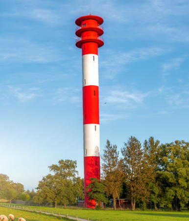
1969 (station established 1830). Active; focal plane 60 m (197 ft); red flash every 5 s; also continuous white, red, and green directional lights at a focal plane of 24 m (79 ft). 64 m (210 ft) round aluminum-clad concrete and steel tower with flared top, lantern, and gallery, plus a round observation and control room at the 23 m (75 ft) level. Lighthouse painted with red and white horizontal bands; lantern is white. Rieke Müller's 2023 photo is at the top of this page, the Leuchtturm-Atlas site for the lighthouse includes a portfolio of photos, Trabas also has a good photo by Capt. Peter, Monika Buss has a 2022 photo, Werning has a photo, Marinas.com has aerial photos, and Google has a satellite view. This is Germany's second tallest lighthouse, built as a landfall light for shipping, especially supertankers, arriving in Wilhelmshaven. It also serves as the traffic control center for Wilhelmshaven. Located near the west end of Wangerooge. Site open, tower closed. Operator: WSA Weser-Jade-Nordsee. . ARLHS FED-251; DE 318500; Admiralty B1112; NGA 10192.
**** Wangerooge (2) (Alter Turm)
1856 (station established 1830). Inactive since 1969. 39 m (128 ft) round stone tower clad in metal (steel?) plates, rising from a round 1-story base and topped by a 3-story extension with lantern and gallery. Tower painted red, extension white, lantern black with a green (copper) conical roof. A 2020 photo is at right, Werning has a good photo, Leuchtturm-Atlas has a page with a photo, Huelse has a historic postcard view, Martin Pohl has a street view, Clemens Scharmann has a closeup street view, and Google has a satellite view. This lighthouse replaced a 23 m (75 ft) stone tower that stood near the site of the 1969 lighthouse. The lighthouse was only 30 m (98 ft) tall, with a small conventional lantern, when it was first built. The 3-story extension with its large lantern was added in 1927. When it was deactivated in 1969 the municipality bought it for a token 1 Deutsche Mark. Since 1972 the tower has housed a local history museum. Located near the center of the island about 6 km (4 mi) east of the Neuer Turm. Site open, museum open daily, tower open for climbing during museum hours. Owner: Municipality of Wangerooge. Site manager: Inselmuseum Wangerooge. . ARLHS FED-252.

Wangerooge Alter Light, Wangerooge, September 2020
Instagram photo by meinwangerooge
 

Jade Entrance Lighthouses
The Jade Bight or Jade Bay (Jadebusen in German) is an inlet of the North Sea leading to the port of Wilhelmshaven. Not a historic feature of the coast, the bay was formed by sea level rise during the 13th and 14th centuries and has been shaped by engineering during more recent times.

Mellumplate
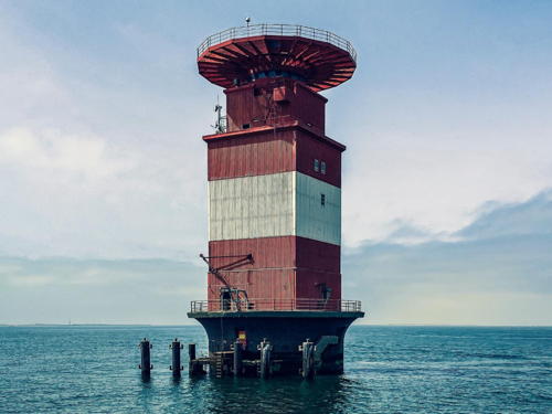
1946. Active; focal plane 27 m (89 ft); white directional light, continuous along the line of the channel; white flashes in various patterns in other directions. Vessels slightly south of the channel see a short and long flash every 7.5 s, and those further south see a single flash every 4s. Vessels slightly north of the channel see a long and a short flash every 7.5 s, and those further north see four white flashes every 15 s. 32 m (105 ft) square cylindrical tower with gallery, topped by a helipad, mounted on a round caisson. Lighthouse painted red with one white horizontal band. A 2023 photo is at right, WSA Weser-Jade-Nordsee has a page for the lighthouse, Leuchtturm-Atlas has a page with a photo, Werning has a fine photo, Trabas has a closeup photo by Manfred Schüler, Wikimedia has a portfolio of photos, and Bing has a satellite view. This tower was actually completed in 1942 and for the rest of World War II it supported an antiaircraft battery. British occupying forces activated the lighthouse at the end of the war. The lighthouse is an approach leading light for Wilhelmshaven, guiding ships past the Mellumplate (Mellum Flats), a broad shallow area in the mouth of the Jade. In 2007 it was renovated with powerful new optics. Located about 6 km (4 mi) east of Schillig. Accessible only by boat; there are boat tours in the summer from the Hooksiel outer harbor. Site and tower closed. Operator: WSA Weser-Jade-Nordsee. . ARLHS FED-017; DE 318600; Admiralty B1122; NGA 10316.
Minsener Oog Buhne A
1939. Inactive since 1998. 17 m (56 ft) square cylindrical tower with lantern on a square concrete base; tower unpainted, lantern painted red. Lars Everding has a 2022 photo, Werning has a recent photo, Leuchtturm-Atlas has a page with a photo, and Google has a satellite view. Gravely endangered: undermined by the sea, this lighthouse has an increasing tilt to seaward, and it is likely to collapse in the near future. Built at the end of a breakwater at Minsener Oog, about 10 km (6 mi) northeast of Schillig. Most of the breakwater is gone or underwater, leaving the lighthouse at sea. Note: oog is Frisian for "eye" and a buhne is a groin or breakwater. Minsener Oog is a small, sandy island on the west side of the Jade entrance. Located about 3 km (2 mi) east of the eastern tip of Wangerooge. Accessible only by boat. Site and tower closed (the island is restricted as a bird sanctuary). Site manager:WSA Weser-Jade-Nordsee. ARLHS FED-154; ex-Admiralty B1124.

Mellumplate Light, Jadebusen, June 2023
Instagram photo by pankm4n
Minsener Oog Buhne C
1976. Inactive since 1998. 53 m (174 ft) tower: round cylindrical concrete tower topped by a tall skeletal communications tower, with radar equipment on a large square platform at about the 22 m (72 ft) level; the light was displayed from a post on a small landing just above this platform. Tower painted with black and white horizontal bands. The radar facilities are still in use. Werning has a good page for the lighthouse, Leuchtturm-Atlas has a page with a photo, another photo is available, and Google has a satellite view. Located on the east side of the sandbank known as Minsener Oog, marking the west side of the entrance to the Jade. Accessible only by boat. Site and tower closed (the island is restricted as a bird sanctuary). Site manager: WSA Weser-Jade-Nordsee. . ARLHS FED-013; ex-Admiralty B1128.

Wangerland Lighthouses
* Schillig Unterfeuer (2)
1961 (station established 1916). Inactive since 1998; charted as a daybeacon. 16 m (52 ft) steel tripod tower with lantern and gallery, painted black. The range was discontinued in 1987, and the tower then carried a directional light until 1998. The range towers continue to be maintained as a day range. Hans-Joachim Hötger's 2020 photo is at right, a closeup photo is available, Werning has a photo, Leuchtturm-Atlas has a good view of the range as seen from the Jade, and Google has a closeup street view and a satellite view. Huelse has a postcard view of the original light. The Schillig Range was discontinued in 1987 but this front light continued in use until 1998. Located in a large campground just behind the beach on the west bank of the Jade in Schillig. Site open, tower closed. Operator: WSA Weser-Jade-Nordsee. Site manager: Schillig Campingplatz. ARLHS FED-213; ex-Admiralty B1132.
* Schillig Oberfeuer (2)
1961 (station established 1877). Inactive since 1987. 42 m (138 ft) round cylindrical concrete tower with gallery, painted yellow. The tower continues to carry communications antennas. Richard Höllmann has a 2021 photo, Wikimedia has a photo, Werning's page has a photo, Marinas.com has aerial photos, and Google has a street view and a satellite view. The original light, on a tall mast, is seen in one of Huelse's postcard views, and another postcard view shows the present tower before the communications gear was added. Located approx. 2 km (1.2 mi) west of Schillig. Operator: WSA Weser-Jade-Nordsee. ARLHS FED-215; ex-Admiralty B1132.1.

Schillig Unterfeuer, Schillig, November 2020
Google Maps photo by Hans-Joachim Hötger

Wilhelmshaven Lighthouses
Voslapp Unterfeuer
1962. Active; focal plane 15 m (49 ft); white light, 3 s on, 3 s off, synchronized with the rear range light. 17 m (56 ft) round cylindrical concrete tower with gallery, painted with red and white horizontal bands. WSA Weser-Jade-Nordsee has a page for the range lighthouses, Werning has a good photo, Trabas has a closeup photo by Capt. Peter, and Google has a satellite view. This range guides vessels in the northern part of the approach to Wilhelmshaven. The Voslapp range lights replaced a single lighthouse, built in 1907 and seen in Huelse's historic postcard view. Located a short distance offshore about 4 km (2.5 mi) north of Voslapp. Accessible only by boat, but there are excellent views from the shore. Operator: WSA Weser-Jade-Nordsee. ARLHS FED-248; DE 318800; Admiralty B1138; NGA 10212.
* Voslapp Oberfeuer (2)
1962 (station established 1907). Active; focal plane 62 m (203 ft); white light, 3 s on, 3 s off, synchronized with the front range light. 64.5 m (212 ft) round cylindrical concrete tower with three galleries as a topmark, painted with red and white horizontal bands. A 2023 photo by Rainer Ganske is at right, WSA Weser-Jade-Nordsee has a page for the range lighthouses, Werning has a good photo, Trabas has a photo by Capt. Peter, Wikimedia has several photos, Rolf Tiegs has a street view, and Google has a satellite view. This is Germany's third tallest lighthouse. Located 4.3 km (2.7 mi) south southwest of the front light, just behind the Jade-Weser-Port information center at Voslapp, about 8 km (5 mi) north of Wilhelmshaven. Site open, tower closed. Operator: WSA Weser-Jade-Nordsee. . ARLHS FED-249; DE 318801; Admiralty B1138.1; NGA 10216.
Niedersachsenbrücke Oberfeuer
Date unknown. Active; focal plane 13 m (43 ft); continuous white light. 14 m (46 ft) square cylindrical skeletal tower carryiung a triangular daymark, point down. Trabas has Capt. Peter's photo but the light is inconspicuous in Google's satellite view. The range guides ships at a container terminal on the north side of Wilhelmshaven. The front light is on a shorter skeletal tower. Located on a pier on the south side of the terminal. Site and tower closed. DE 319561; Admiralty B1139.1; NGA 10224.
Neuer Vorhafen East Mole
Date unknown. Active; focal plane 15 m (49 ft); red light, 4.5 s on, 1.5 s off. 12 m (39 ft) slender cylindrical steel tower painted red. Trabas has a closeup photo by Capt. Peter and Google has a satellite view. There is also a mast light on the west side of the harbor entrance. Located at the end of the main breakwater of the Vorhafen (outer harbor) of Wilhelmshaven. Site status unknown. DE 319630; Admiralty B1159; NGA 10276.

Voslapp Oberfeuer, Voslapp, October 2023
Instagram photo by Rainer Ganske
Wilhelmshaven Vorhafen (Seeschleusen) Oberfeuer
1960s. Active; focal plane 23 m (76 ft); white light, 2 s on, 2 s off. 22 m (72 ft) square building, about 6 stories tall, with light mounted on the roof. Hartmann also has a page for the range, Trabas has a photo and Google has a satellite view. This light is at the rear of the Vorhafen (outer harbor) of Wilhelmshaven, on a rectangular artificial island between the two locks (Seeschleusen) that provide entry to the protected inner harbor. The top floor of the building is the control room for the locks. The front light is on a steel post 180 m (590 ft) in front of the building, at the outer edge of the island. Site status unknown but probably closed to the public. Operator: WSA Weser-Jade-Nordsee. ARLHS FED-262; DE 319601; Admiralty B1156.1; NGA 10268.
Wilhelmshaven Marinemole (replica)
2006. Inactive. 9 m (30 ft) four-legged tower with lantern and gallery standing on a square masonry base. The original lighthouse (ex-Admiralty B1162) was deactivated at the end of July 2005 and in November it was sold and relocated to Dangast (see below). This caused a public outcry and in the fall of 2006 an exact replica of the original was constructed. Marini Käfer has a 2021 photo, Werner Otten has a closeup photo and Google has a street view and a satellite view. Located at the end of a curved mole off the Schleusenstraße near the west end of Wilhelmshaven harbor. Accessible by walking the mole; parking is available nearby. Site open, tower closed. Owner/site manager: Port of Wilhelmshaven.
Feuerschiff Wilhelmshaven (Norderney I)
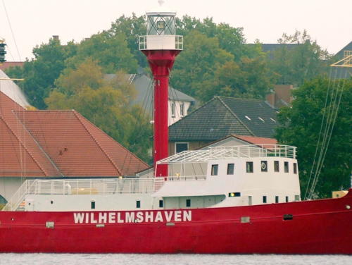
1907. Decommissioned 1981. 46 m (151 ft) steel lightship with cylindrical light tower amidships, lantern, and gallery. Hull and light tower painted red, superstructure and lantern painted white. A 2009 photo is at right, Bernd Bölscher has a good 2013 photo, and a 2014 photo is available. The ship was built as the Norderney and served for many years as a reserve vessel. After a modernization it was assigned in 1956 to its last station off the mouth of the Weser. In 1983 the ship was donated to the city of Wilhelmshaven, which leased it to a sailing club. Restored first as a restaurant, it has also been used as a youth hostel. In recent years it was a museum and the headquarters ship of a club, the Seglerkameradschaft Klaus Störtebeker. It was moored at the Bontekai, a section of Wilhelmshaven's inner harbor just west of the historic Kaiser Wilhelm Bridge (also built in 1907). In 2017 it was removed from that location. In September 2018 Manfred Schmidt found it moored in the nearby Handelshafen with its lantern removed. The city agreed to restore the ship and return it to the Bontekai; the federal government announced that it would contribute a portion of the funds needed. Andreas Köhler visited in 2020 and found the restoration was underway and by late in the year the ship was back at its old location. In September 2022 the city advertised for bids to do a complete restoration to ready the ship for display at the Küstenmuseum (Coastal Museum). As a result of the restoration the ship was renamed Wilhelmshaven. Shipspotting.com has the October 2024 photo at right, Jan Grünhagen has a 2025 photo, and another 2025 photo is available, but the ship is not yet seen in Google's satellite view of the museum. Owner/site manager: City of Wilhelmshaven. ARLHS FED-143.

Feuerschiff Wilhelmshaven, Wilhelmshaven, October 2024
Shipspotting.com photo copyright MarcusShips

Jade Basin Lighthouses
The Jade Basin is a roughly triangular basin south of Wilhelmshaven at the head of the Jade Bight.

Jappensand Unterfeuer
2012. Active; focal plane 15 m (49 ft); white light, 1.5 s on, 1.5 s off. 21 m (69 ft) round cylindrical steel tower painted with red and white horizontal bands. Trabas has Capt. Peter's photo, Sascha Durmann has a 2021 photo, and Google has a satellite view. The Jappensand Range replaced the older Eckwarden Range (see below): it is the third range for ships arriving in Wilhelmshaven. The lights were prefabricated and installed by Ludwig-Voss GmbH & Co.KG of Cuxhaven. Located off Wilhelmshaven in the entrance to the Jadebusen. Accessible only by boat; there is a good distant view from the Wilhelmshaven Marinemole lighthouse. Site open, tower closed. DE 319360; Admiralty B1161.
Jappensand Oberfeuer
2012. Active; focal plane 38 m (125 ft); white light, 1.5 s on, 1.5 s off. 44 m (144 ft) round cylindrical steel tower painted with red and white horizontal bands. Trabas has Capt. Peter's photo, Sascha Durmann has a 2020 photo, and Google has a satellite view. Located about 1.2 km (3/4 mi) south of the front light. Accessible only by boat. Site open, tower closed. DE 319361; Admiralty B1161.1.
Arngast
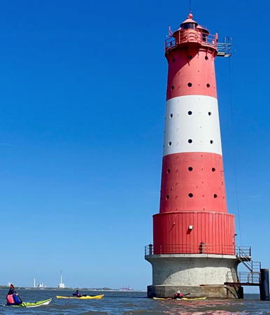
1910. Active; focal plane 30 m (99 ft); directional light; depending on direction vessels may see a continuous white, red, or green light, a white or green flash every 3 s, two white flashes every 9 s, or a white light occulting once every 6 s. 36 m (118 ft) round cast iron tower with a large lantern and gallery, plus a smaller lantern mounted at one side of the gallery, mounted on a concrete pier. Lighthouse painted red with one white horizontal band. A 2021 photo is at right, Werning has a good photo, Hartmann has a page for the lighthouse, Trabas has a good closeup photo by Manfred Schüler, the Leuchtturm-Atlas site has a portfolio of photos, Wikimedia has photos, Huelse has a historic postcard view, and Google has a satellite view. This venerable offshore lighthouse stands on a submerged sandbank (formerly the island of Arngast) in the middle of the Jadebusen (Jade Bay), with its 13 sectors guiding vessels on various courses through the bay's tricky channels. One of the white sectors guides ships on their final approach to Wilhelmshaven. In 2003 the tower was listed by the federal government as a historic building. Located about 5 km (3 mi) south of Wilhelmshaven; distantly visible from the Wilhelmshaven waterfront and many other locations around the roughly circular bay. Accessible only by boat. Site and tower closed. Operator:WSA Weser-Jade-Nordsee. . ARLHS FED-021; DE 319500; Admiralty B1152; NGA 10300.

Arngast Light, Jade Bay, September 2021
Instagram photo by eine.insel.namens.udo

Varel Lighthouse
* Wilhelmshaven Marinemole (relocated to Dangast)
1975. Inactive since 2005. 9 m (30 ft) four-legged tower with lantern and gallery. Lighthouse painted black. Leuchtturm-Atlas reports that this lighthouse was deactivated at the end of July 2005. In November 2005 it was sold to Capt. Anton Tapken, who relocated the lighthouse to Dangast, a village on the southwestern shore of Jade Bay. A photo of the relocated lighthouse is available, Werning's page has a photo, Kevin Schulz has a 2021 street view, and Google has a 2017 street view and an indistinct satellite view. Located on the west side of the harbor entrance in Dangast, a village in Varel Municipality on the southwest shore of Jade Bay. Site open, tower closed. Site manager: private. ARLHS FED-263; ex-Admiralty B1162.

Western Wesermarsch District Lighthouses

The Wesermarsch district includes the Butjadingen peninsula between the Jade and Weser estuaries. The lighthouse of this group are on the west side of the peninsula and the east side of the Jade, opposite Wilhelmshaven. For Butjadingen lighthouses of the Weser, see the Bremen and the Weser page.

Butjadingen West Coast Lighthouses
* Eckwarden Oberfeur (2)
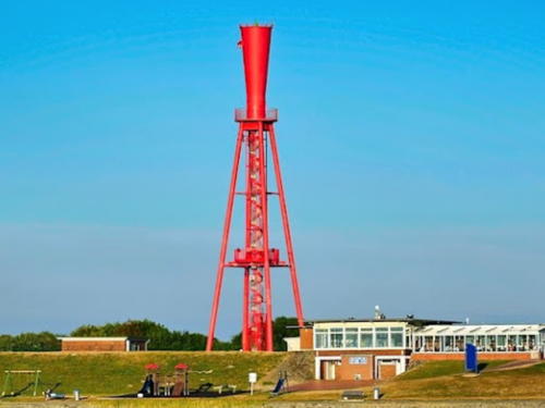
1962 (station established 1914). Inactive since 2012. 37 m (121 ft) square pyramidal skeletal tower with gallery and a thin funnel-shaped topmark. Access to the light is by an unenclosed spiral stairway. Entire lighthouse painted red. Hans-Georg Kiewit's 2022 photo is at right, the Leuchtturm-Atlas page has a portfolio of photos, Hartmann has a page for the range lights, Heribert Duling has a 2021 photo, Wolfgang Wessels has a 2016 street view, Werning has a photo, and Google has a 2023 street view and a satellite view. Huelse has a historic postcard view of the original lighthouse. This unusual lighthouse anchored a southbound range guiding ships to Wilhelmshaven; it is 2350 m (1.5 mi) south southeast of the former front range location. The range was replaced by the Jappensand Range (see above) in 2012. Located at Eckwarden on the east side of the Jade directly opposite Wilhelmshaven. Site open, tower closed. Operator: WSA Weser-Jade-Nordsee. ARLHS FED-078; ex-Admiralty B1141.1; ex-NGA 10260.
#Eckwarden Unterfeuer (2)
1962 (station established 1914). Inactive since 2012. This was an 18 m (59 ft) round cylindrical concrete tower with lantern and gallery, painted with red and white horizontal bands; lantern and gallery painted red. Werning has a closeup, Sascha Durmann has a photo, and Google has a satellite view. Formerly located in shallow water of the Jade about 2.5 km (1.5 mi) northwest of Eckwarden, the light was removed immediately after being deactivated. In 2019 the stored light tower was sold to a private person who plans to relocate it to Wurster Nordseeküste north of Bremerhaven. ARLHS FED-077; ex-Admiralty B1141; ex-NGA 10256.
* Tossens Oberfeuer (2)
1987 (station established 1973). Active; focal plane 51 m (167 ft); white light occulting once every 6 s. 52 m (171 ft) round cylindrical concrete tower with a 3-ringed topmark, painted with red and white horizontal bands. Hartmann has a page for the range lights, Werning has an excellent photo, Trabas has a photo, a 2020 photo is available, and Google has a 2023 street view and a satellite view. This lighthouse anchors the second southbound range (following the Voslapp Range) guiding ships to Wilhelmshaven; it is 3860 m (2.4 mi) southeast of the front range. Located just behind the dike on the east side of the Jade about 3 km (2 mi) south of Tossens. Site open, tower closed. Operator: WSA Weser-Jade-Nordsee. ARLHS FED-239; DE 319231; Admiralty B1134.1; NGA 10248.1.

Eckwarden Oberfeuer, Eckwarden, September 2022
Google Maps photo by Hans-Georg Kiewit
* Tossens Oberfeuer (1)
1973. Inactive as a lighthouse since 1988. 51.5 m (170 ft) round cylindrical concrete tower with a round control room near the top. Dirk Michel has a photo, Andre Haag has a 2023 photo, Jörg Weigand has a distant street view, and Google has a satellite view. The tower remains in use as a radar tower for vessel traffic control. Located on the southwest edge of the village of Tossens. Site and tower closed but the tower is easily seen from anywhere nearby. Owner/operator: WSA Weser-Jade-Nordsee.
Tossens Unterfeuer
1973. Active; focal plane 15 m (49 ft); white light occulting once every 6 s. 17 m (56 ft) round cylindrical concrete tower with a 2-ringed topmark, painted with red and white horizontal bands. Hartmann has a page for the range lights, Benjamin Bellardita has a 2019 closeup photo, Chris Ahnert has a 2022 photo, Trabas has Capt. Peter's photo and Google has a satellite view. Located in shallow water of the Jade about 2 km (1.2 mi) east of Tossens. Accessible only by boat. Site and tower closed. Operator: WSA Weser-Jade-Nordsee. ARLHS FED-238; DE 319230; Admiralty B1134; NGA 10248.
[Sengwarder Balje Unterfeuer]
1906. Inactive since 1961. This was formerly an approx. 10 m (33 ft) round tower with lantern and gallery mounted on a round pier. A historic photo is available. This was an entrance range for the Jade. The lighthouse was demolished after the range was discontinued and a post with a double-ball topmark was installed to mark the remaining hazard. A 2022 photo is available and Google has an indistinct satellite view. The rear light was on a slender skeletal tower about 1.2 km (3/4 mi) southeast; it was removed in 1971 and only its concrete foundation remains. Located on the east side of the Jade channel opposite the Voslapp docks. Accessible only by boat. Site open, tower closed.
Hooksielplate
1976. Main light inactive since 1998; a fog detection light was added in 2012. 55 m (180 ft) structure: round cylindrical concrete tower with a square platform, equipment room, and gallery, topped by a tall communications tower. Tower painted with red and white horizontal bands. The light was displayed from the platform at the 25 m (82 ft) level. The lighthouse continues in use as a radar tower. A 2023 photo is at right, Leuchtturm-Atlas also has a good photo, Werning's page has a good photo, Thorolf Glöckner has a photo, Trabas has Capt. Peter's photo, and Google has a satellite view. Located on the east side of the Jade about 8 km (5 mi) southeast of Schillig. Accessible only by boat. Site and tower closed. Operator: WSA Weser-Jade-Nordsee. . ARLHS FED-114; Admiralty B1133.

Hooksielplate Light, Jadebusen, March 2023
Instagram photo by Claus M.

Inland Lighthouse

* Barßel
1986. Active; focal plane 15 m (49 ft); flashing white light. 14 m (46) slender round tower with a small lantern and gallery, painted with red and white horizontal bands. A 2023 closeup photo is another available, Hauke Musicaloris has a closeup street view, and Google has a satellite view and a distant street view. The lighthouse was built by the local boating club, the Barßeler Schifferverein. Located on the pier at Barßel, a town on the Soeste River, an upper tributary in the Ems drainage. Accessible by walking the pier. Site open, tower closed. .

Information available on lost lighthouses:

Notable faux lighthouses:

Adjoining pages: Northeast: Bremerhaven | Southeast: Bremen and the Weser | West: Northeastern Netherlands

Return to the Lighthouse Directory index | Ratings key

Posted February 26, 2005. Checked and revised February 27, 2025. Lighthouses: 45; lightships: 3. Site copyright 2025 Russ Rowlett and the University of North Carolina at Chapel Hill.