Lighthouses of Spain: Menorca

The Kingdom of Spain occupies nearly 85% of the Iberian Peninsula in southeastern Europe with coastlines facing south and southeast on the Mediterranean Sea and northwest on the Atlantic Ocean. Spain also includes the Balearic Islands in the Mediterranean, the Canary Islands in the Atlantic, and the cities of Ceuta and Melilla on the north coast of Morocco.

The Balearic Islands are an archipelago in the Mediterranean off the east coast of Spain. Mallorca (Majorca) is by far the largest of the islands; the other principal islands are Menorca (Minorca) to the northeast and Ibiza (Eivissa) and Formentera to the southwest. The islands were conquered by the Kingdom of Aragon in the 13th century and have been part of Spain for several centuries. The Catalan language is spoken and the islands are known officially by their Catalan name, Illes Balears. In the 20th century the Balearics became very popular resort destinations. The islands are one of the 17 autonomous communities (comunidads autónoma) into which Spain is divided. They form a single province but each of the four major islands has an insular council for local government.

This page describes lighthouses of Menorca; there is are separate pages for Mallorca and for Ibiza and Formentera. Menorca (traditionally spelled Minorca in English) is the second largest of the Balearic Islands, with a population of about 100,000. Britain seized control of the island in 1708 and kept control for most of the Eighteenth Century, leaving behind a British influence still noticeable today.

In Catalan the word for a lighthouse is far, balisa is a beacon, illa is an island, cap is a cape, punt is a promontory or point of land, roca is a rock, escull is a reef, badia is a bay, ria is an estuary or inlet, estret is a strait, riu is a river, and port is a port or harbor. The word for a lighthouse is faro in Spanish but its use is generally restricted to the larger coastal light stations. Smaller lighthouses are called balizas (beacons). In Spanish isla is an island, cabo is a cape, punta is a promontory or point of land, péñon is a rock, arrecife is a reef, bahía is a bay, ría is an estuary or inlet, estrecho is a strait, río is a river, and puerto is a port or harbor.

Navigational lights in Spain are the responsibility of the national port authority, Puertos del Estado, but many of them are operated and maintained by regional port authorities. The Balearics have their own port authority, the Autoritat Portuària de Balears. The Comisión de Faros, founded in 1842 to build and maintain Spanish lighthouses, is now an advisory panel.

ARLHS numbers are from the ARLHS World List of Lights. ES numbers are from the Spanish national list of lights, Libro de Faros. Admiralty numbers are from volume E of the Admiralty List of Lights & Fog Signals. U.S. NGA List numbers are from Publication 113.

General Sources
Fars de Balears
An outstanding and comprehensive web site, with versions in English as well as Spanish and Catalan.
Online List of Lights - Islas Baleares and Menorca East Coast
Photos by various photographers posted by Alexander Trabas.
Leuchttürme.net - Islas Baleares
Photos of Mallorca lighthouses posted by Malte Werning.
Faros de las Islas Baleares
Photos by Laure Chappuis, posted by Alain Guyomard and Robert Carceller.
Lighthouses in Balearic Islands
Photos by various photographers available from Wikimedia.
World of Lighthouses - Non-continental Spain
Photos by various photographers available from Lightphotos.net.
Lighthouses in Spain
Fine aerial photos posted by Marinas.com.
Leuchttürme Spaniens auf historischen Postkarten
Historic postcard images posted by Klaus Huelse.
GPSNauticalCharts
Navigational chart information for the islands.


Ciutadella Light, Ciutadella de Menorca, August 2022
Instagram photo by Pati Blanco

Ciutadella de Menorca (Western Menorca) Lighthouses
** Cap d'Artrutx
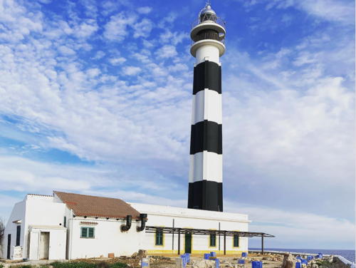
1859 (Emili Pou) (substantially modified in 1970). Active; focal plane 45 m (148 ft); three white flashes every 10 s. 34 m (111 ft) round concrete tower with four ribs, lantern, and double gallery. Lighthouse painted with black and white horizontal bands; lantern is gray metallic. A 2022 photo appears at right, Trabas has Andreas Köhler's closeup 2019 photo, Dario Santos has a 2021 photo, Fran Martinez has a view from the sea, Wikimedia has a good photo, Marinas.com has aerial photos, and Google has a street view and a good satellite view. The tower was doubled in height in 1970 and the four buttresses were added to help support it; the double gallery was also added. The keeper's house now includes a bar and snack restaurant. Cap d'Artrutx is the southwesternmost point of Menorca and unlike most points of land in the Balearics it is quite low. Located at the end of Plaça Far in the town of Cap d'Artrutx. Site and keeper's house open, tower closed. . ARLHS BAL-015; ES-36420; Admiralty E0342; NGA 5184.
* Ciutadella (Punta de sa Farola)
1863 (modified in 1979) (Emili Pou). Active; focal plane 21 m (69 ft); white light occulting five times, in a 2+3 pattern, every 14 s. 13 m (43 ft) round cylindrical masonry tower with lantern and double gallery, rising from a 1-story masonry keeper's house. Lighthouse painted with black and white vertical stripes; lantern is gray metallic. Pati Blanco's 2022 photo is at the top of this page, Trabas has Werner Seiler's closeup 2004 photo, Virgílio Vilela has a photo, Roc Garcia-Elias has a photo, and Google has street view and a satellite view. In 1979 the tower was increased in height and the double gallery was added. Located on on the Cami Farola on the west side of the harbor entrance in Ciutadella de Menorca, on the west end of the island. Site open, tower closed. . ARLHS BAL-078; ES-36470; Admiralty E0344; NGA 5188.

Cap d'Artrutx Light, Ciutadella de Menorca, March 2022
ex-Instagram photo by bedmar83
* Punta Nati (Cabo Nati)
1913 (Mauro Serret). Active; focal plane 42 m (138 ft); four white flashes, in a 3+1 pattern, every 20 s. 19 m (62 ft) octagonal masonry tower with lantern and gallery, attached to the front of a 1-story U-shaped masonry keeper's house. The lighthouse is unpainted stone; lantern is gray metallic. A 2025 photo is at right, Trabas has a 2013 photo by Alfonso Biescas Vignau, Manuel Melon has a 2019 photo, Rudi Ceuppens has a good photo, Marinas.com has aerial photos, and Google has a closeup street view and a good satellite view. This lighthouse on the relatively wild and barren northwest coast of Menorca is not often visited. Located at the end of secondary road CF-5 about 6 km (4 mi) north of Ciutadella de Menorca. Site open, tower closed. . ARLHS BAL-026; ES-36680; Admiralty E0348; NGA 5220.

Es Mercadal (North Coast) Lighthouses
*** Cap de Cavallería (Cabo Caballeria)
1857. Active; focal plane 94 m (308 ft); two white flashes every 10 s. 15 m (49 ft) round masonry tower with lantern and gallery, rising from the front of 1-story masonry keeper's house. Lighthouse painted all white; lantern is gray metallic. Xavier Llobet's 2021 photo is below right, Trabas has a 2006 photo, an excellent closeup is available, Wikimedia has several photos, David Martínez has a closeup street view, and Bing has a satellite view. The Cap de Cavallería is a narrow, rocky spine that projects from the north coast of Menorca, forming a very dangerous obstacle for ships. Despite its remoteness the site is accessible by road and is often visited for the spectacular view. There is a café at the light station and a small museum in the lighthouse. Located at the end of secondary road CF-3 about 6 km (4 mi) northwest of Platges de Fornells by sea, but more like 25 km (15 mi) by road. Site open, café and museum open daily May through October, tower closed. . ARLHS BAL-017; ES-35790; Admiralty E0350; NGA 5224.
* Cap de sa Paret
Date unknown. Active; focal plane 29 m (95 ft); white flash every 2 s. Approx. 8 m (26 ft) post attached to a 1-story equipment room. Lighthouse painted white with one black horizontal band. Wikimedia has a closeup photo, Trabas has Andreas Köhler's 2019 photo, and Google has a street view and a satellite view. An ancient fortified tower nearby, the Torre de Fornells, is better known than the light. NGA misspells the name as Cap de sa Pared. Located on a promontory on the west side of the entrance to Fornells. Accessible by a short walk from nearby parking at the end of the Carrer de Tramuntana. Site open, tower closed. ES-35800; Admiralty E0350.5; NGA 5226.
Fornells Range Front
Date unknown. Active; focal plane 14 m (46 ft); quick-flashing red light. 6 m (20 ft) octagonal white concrete tower with vertical red stripes. Trabas has Andreas Köhler's photo, Juan Miguel Serrano Mateo has a view from the sea of both range lights, and Google has a satellite view. Located on the Illa Sargantana, a small island in Fornells harbor. Accessible only by boat. Site open, tower closed. ES-35840; Admiralty E0351; NGA 5228.
Fornells Range Rear
Date unknown. Active; focal plane 23 m (75 ft); red light, 2 s on, 2 s off. 9 m (30 ft) octagonal white concrete tower with vertical red stripes. Trabas has Andreas Köhler's photo, Juan Miguel Serrano Mateo has a view from the sea of both range lights, and Google has a satellite view. Located on the Illa Sargantana, a small island in Fornells harbor. Accessible only by boat. Site open, tower closed. ES-35841; Admiralty E0351.1; NGA 5232.


Punta Nati Light, Ciutadella de Menorca, June 2025
Instagram photo by Conny


Cap de Cavallería Light,Es Mercadal , July 2021
Google Maps photo by Xavier Llobet


Maó Lighthouses
Maó (Mahón in Spanish, spelled Mahon and pronounced Ma-On in English) is the capital of Menorca. Its English name is a reminder that Britain occupied Menorca for most of the 18th century (1708-1756, 1763-1782, and 1798-1802). The harbor is an important naval base for the Spanish fleet today as it was for the British fleet then.

*
Cap Favàritx
1922 (Miguel Massenet). Active; focal plane 47 m (154 ft); three white flashes, in a 1+2 pattern, every 15 s. 28 m (92 ft) round masonry tower with lantern and double gallery, rising from one end of a 2-story masonry keeper's house. Lighthouse painted with black and white spiral bands; lantern is gray metallic. Oliver Isermann's 2024 photo is at right, Trabas has Werner Seiler's 2004 photo, Jesús Rubial has a 2022 photo, another good photo is available, Massimo Scarano has a 2022 photo, Wikimedia has several views, Marinas.com has aerial photos, Jon Thomson has a street view, and Google has a satellite view. Cap Favàritx is a sharp promontory projecting from the northeastern coast of Menorca. Located at the end of secondary road CF-1 about 12 km (7.5 mi) off the main road ME-7. Accessible by a short hike from the parking area. Site open, tower closed. . ARLHS BAL-022; ES-35900; Admiralty E0352; NGA 5236.
Punta S' Esperó (Punta del Espero0 (2)
Date unknown. Active; focal plane 22 m (72 ft); three white flashes, in a 1+2 pattern, every 15 s. Approx. 8 m (26 ft) round fiberglass tower with a conical base, colored with black and white horizonyal bands. A May 2021 photo is available. This light replaced an 11 m (36 ft) round cylindrical tower, painted with black and white horizontal bands, rising from one end of 1-story equipment building. Trabas has Andreas Köhler's 2019 photo of the older light and Google has a satellite view. Located on the easternmost tip of Menorca, about 2.5 km (1.5 mi) northeast of the entrance to the Port de Maó. Site status unknown, tower closed. ARLHS BAL-067; ES-35940; Admiralty E0355; NGA 5238.
* Maó Directional
Date unknown. Active; focal plane 9 m (30 ft); white, red or green light depending on direction, 2 s on, 2 s off. Light mounted atop a 2-story building. Building painted white. Trabas has Andreas Köhler's 2019 photo, Alejandro Luis Carreras has a street view and Google has a satellite view. The light guides ships within Maó's inner harbor. Located on a pier on the north side of Maó harbor. Site open, tower closed. ES-35960; Admiralty E0361.65; NGA 5278.

Cap Favàritx Light, Maó, May 2024
Instagram photo by Oliver Isermann

Es Castell Lighthouses
* Punta de Ne Cafayas (Calas Fonts, Villacarlos)
Date unknown. Active; focal plane 8 m (26 ft); three red flashes every 9 s. 7 m (23 ft) small round tower, painted red, adjoining a white 1-story equipment shelter. Trabas has Andreas Köhler's photo, and Google has a closeup street view and an indistinct satellite view. Calas Fonts is a popular waterfront district in Es Castell, on the east side of Maó. Located on a promontory projecting into the harbor; the little lighthouse stands in a parking lot on the Paseo de Santa Agueda. Site open, tower closed. ES-36090; Admiralty E0358; NGA 5256.
Illa del Rei (Isla del Rey, Isla del Hospital)
Date unknown. Active; focal plane 13 m (43 ft); four green flashes every 11 s. 13 m (43 ft) round cylindrical concrete tower, painted white with slender green triangle daymarks. Trabas has Andreas Köhler's photo and Google has a satellite view. The island is the site of the historic British military hospital. Located at the southern tip of an island in the harbor of Máo. Accessible only by boat. Site status unknown. ES-36130; Admiralty E0361; NGA 5268.
San Carles-Maó (Punta de San Carlos, Puerto de Mahon) (3?)
1971 (station established 1852). Active; focal plane 22 m (72 ft); white light occulting twice every 6 s. 15 m (49 ft) post with gallery rising from a square white equipment room. Trabas has Andreas Köhler's photo and Google has a satellite view. A page for the light has a photo of the current light and a historic photo of the original lighthouse, a 16 m (52 ft) masonry tower with lantern and gallery attached to a keeper's house. In 1912 it was replaced by a small beacon because it stood in the line of fire of coastal defense artillery. The historic lighthouse was demolished in 1917. Located within the Fort of Sant Felipe on a promontory on the south side of the harbor entrance. Fort open Thursday and Sunday mornings, tower closed. ARLHS BAL-066; ES-35950; Admiralty E0354; NGA 5240.

Sant Lluís Lighthouses
Illa de l'Aire (Isla del Aire, Punta Prima)
1860 (modified in 1965). Active; focal plane 53 m (174 ft); white flash every 5 s. 38 m (125 ft) round masonry tower with lantern and double gallery, rising from a 1-story keeper's house. Lighthouse painted with black and white horizontal bands; lantern is gray metallic. A 2020 photo is at right, Dorit and Jorgen Skovmand have a photo, Elliot Berman has a good photo, Trabas has Andreas Köhler's 2019 photo, Marinas.com has aerial photos, and Google has a satellite view. The tower was reconstructed and the double galleries added in 1965. The Illa de S'Aire is a low, rather flat island, about 1.2 km (0.75 mi) long, located off the southeastern tip of Menorca. Located near Punta Prima, the eastern tip of the island. Accessible only by boat. Site open, tower closed. . ARLHS BAL-002; ES-36370; Admiralty E0366; NGA 5180.

Illa de l'Aire Light, Sant Lluís, August 2020
Google Maps photo by Gigi Rh

Information available on lost lighthouses:

Notable faux lighthouses:,

Adjoining pages: West: Mallorca

Return to the Lighthouse Directory index | Ratings key

Posted March 20, 2006. Checked and revised July 13, 2025. Lighthouses: 14. Site copyright 2025 Russ Rowlett and the University of North Carolina at Chapel Hill.